Scan the QR code and open PeakVisor on your phone
The Castle Peak Wilderness Study Area is a proposed protected region situated in western Colorado in the US. The tallest and most prominent mountain in the wilderness study area is Castle Peak at 11,283 ft (3,439 m) with 3,035 ft (925 m) of prominence.
The Castle Peak Wilderness Study Area is a small area proposed for wilderness protection that’s situated within the Southern Rocky Mountains of western Colorado.
The wilderness study area is home to various types of landscapes through its 12,095 acres (4,895 ha) of land. Elevations in the study area range from around 8,000 ft (2,438 m) up to the summit of Castle Peak.
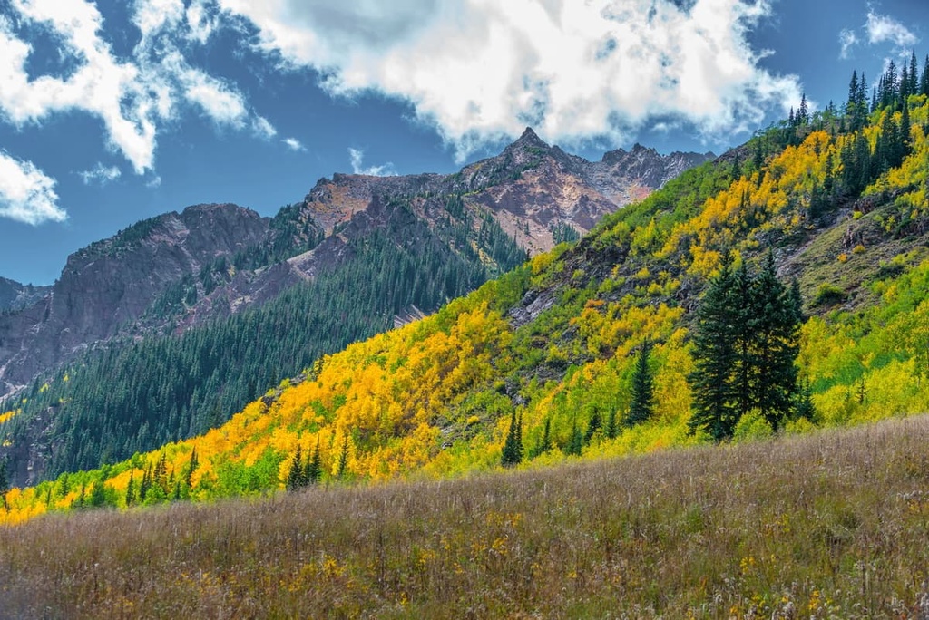
In the study area, rolling forested hills give way to vast basins and alpine meadows with increasing elevation. The major peaks of the region are quite jagged and barren of plant life, so people who summit them are treated to panoramic views of the wilderness and surrounding landscape.
Despite its relatively small size, Castle Peak Wilderness is home to various springs and small lakes, including the scenic Blue Lake. The plethora of creeks in the region has created a wetland habitat that's now a vital component for much of the area’s flora and fauna.
The headwaters of Castle Creek, Catamount Creek, Norman Creek, Milk Creek, Alkali Creek, and Big Alkali Creek are all located within the wilderness.
The Castle Peak Wilderness Study Area is situated near numerous other protected regions for outdoor recreation. These spaces include the Bull Gulch Wilderness Study Area, Flat Tops Wilderness, Eagles Nest Wilderness, and Holy Cross Wilderness Area.
The peaks within Bull Gulch Wilderness are part of the western stretches of the Southern Rocky Mountains, a subrange of the greater Rocky Mountains that extends from southern Wyoming to central New Mexico.
The Southern Rocky Mountains began forming around 300 million years ago. During this period, a range formed throughout present day Colorado. Over the course of millions of years, this range was heavily eroded, an event that laid the framework for the creation of the Southern Rocky Mountains and its many subranges.
The Laramide orogeny occurred from 80 to 55 million years ago, forming much of the range that’s visible today. Immense pressure, caused by the shifting of the tectonic plates in the Earth's crust, thrust the eroded range upwards, creating the region’s distinct jagged peaks that exist to this day.
Much of the landscape was heavily glaciated in the last glacial maximum, around 20,000 years ago. As the glaciers retreated, they carved the landscape, leaving behind cirques, meadows, and rugged peaks.
The rocky landscape within the wilderness study area is primarily a basalt formation with steep and rugged slopes. Throughout the region, there are geological formations that date back from the Cretaceous to the Pleistocene.
The two major peaks within Castle Peak Wilderness Study Area are Castle Peak and Winter Ridge.
The various ecozones within the Castle Peak Wilderness Study Area provide the ideal habitat for a variety of both flora and fauna.
Forested sections of the wilderness study area are populated by aspen and spruce-fir trees. As elevations increase, these forested patches grow smaller, giving way to grassy meadows and steep slopes.
These higher elevations are home to numerous species of wildflowers. Meanwhile, lower elevations are dominated by sagebrush, grasses, and other low growing shrubs.
The multitude of water sources in the wilderness study area attract many animals to the area. This includes Rocky Mountain elk, mule deer, mountain lion, black bear, bobcat, coyote, beaver and raptors. The streams also support the local populations of trout.
The land surrounding the Castle Peak Wilderness has a long human history, dating back thousands of years.
This region of the Rocky Mountains is part of the ancestral homelands of the Ute. Long before the arrival of European Americans, many Ute tribal bands traditionally lived throughout what is now Colorado and Utah.
The Ute are traditionally hunters and gatherers who would migrate with the seasons. Lower elevations of the region were often home to small seasonal settlements while the surrounding mountains were traditionally used for hunting game and gathering food.
The Parianuche band of Ute traditionally gathered food throughout what is now the Castle Peak Wilderness Study Area. Just to the southwest of the wilderness lies natural hot springs that were historically used by numerous tribal nations, too.
Americans of European descent began arriving in the region during the 1820s. Many of the settlers in the region were fur trappers.
The Charles Baker Expedition discovered gold in western Colorado during the 1860s, leading to a massive influx of settlers. Miners, trappers, explorers, and railroad workers flocked to Colorado, often disregarding Indigenous claims to the land.
Violent disputes often occurred between the settlers and Indigenous people, with the settlers often being backed up by the United States government.
Tabeguache Ute Chief Ouray signed a treaty in 1868 that allowed the Ute hunt in the mountains surrounding the wilderness. Shortly after the treaty was signed, settlers forcibly removed the Ute onto reservations.
The building of the railroad in western Colorado, resulted in continued growth for many of the small settlements of the region. Nearby Glenwood Springs was established in 1885, while many of the nearby national forests were established in the early 1900s. The Castle Peak Wilderness Study Area was established in 1980.
Castle Peak Wilderness Study Area is home to few designated hiking trails. Those trails that are within the wilderness are not marked, so hikers should be prepared for off-trail navigation. That said, here are some of the most popular hikes in the region:
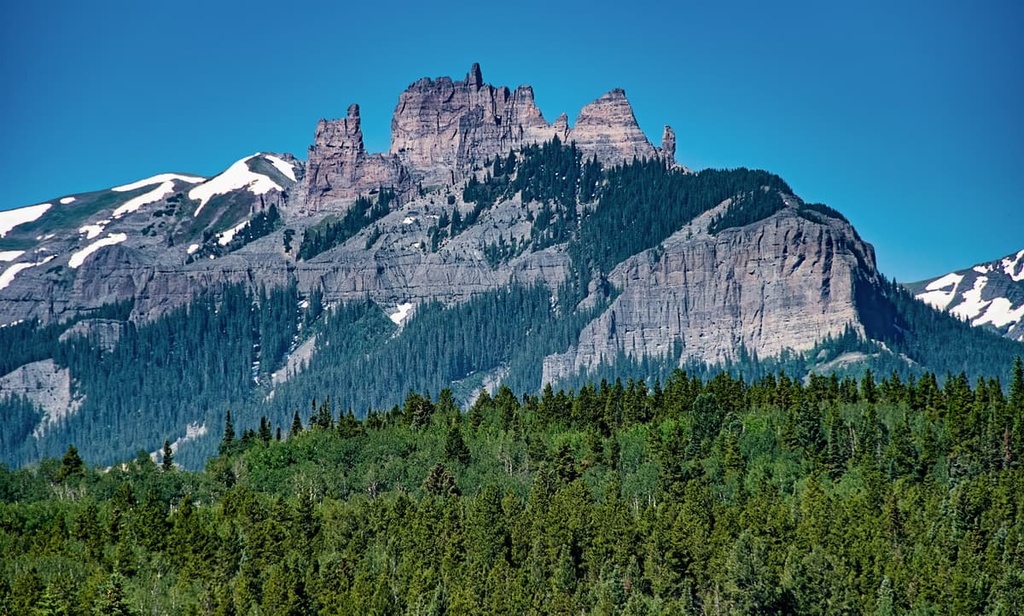
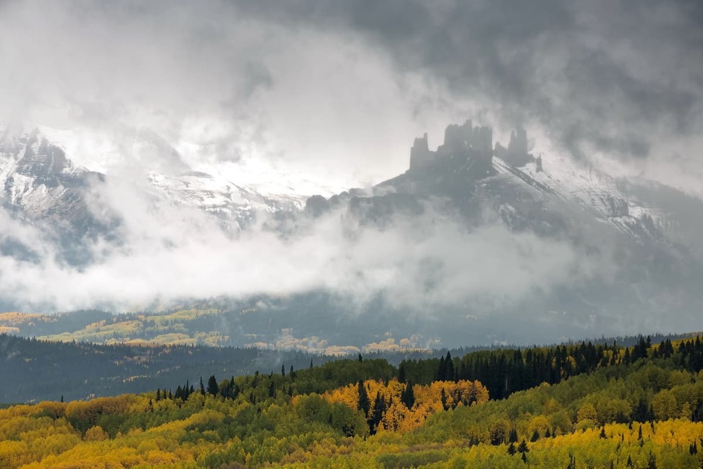
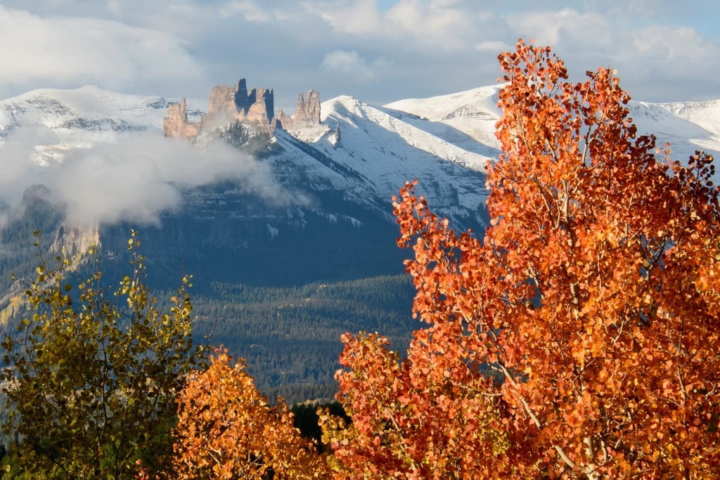
Castle Peak towers above much of the wilderness, marking one of just two named peaks in the area. The summit features a jagged volcanic dike that thrusts out of the broad dome mountain, appearing like a castle tower.
The trail winds through the wilderness, following no clear path, before opening up to the rolling meadow foothills beneath the distinct summit. From there, the easiest route is to climb up the side of the mountain through a section of class 3 scrambling.
Since the wilderness is on Bureau of Land Management land, camping is permitted along the trail, allowing hikers the opportunity to extend the route into a backpacking trip.
The Deep Creek Trail is another unmarked route within the wilderness. As the name suggests, the trail follows along Deep Creek for about 3 miles (4.8 km) before becoming overgrown. Round trip, the trail is 6 miles (9.7 km) in length.
The trail offers views of the forested sections of the wilderness and alpine meadows, the latter of which often feature wildflowers during the summer.
Looking for a place to stay near Castle Peak Wilderness Study Area? Here are some of the best cities and villages to check out in the region:
Glenwood Springs is located just to the southwest of the wilderness and is a hub for year-round outdoor recreation. Additionally, Glenwood Springs is home to natural hot springs that are located within the city limits.
During the summer months, locals and visitors alike can explore the hundreds of miles of trails in the region by hiking, mountain biking, or trail running. Situated along the western slopes of the Rocky Mountains, Glenwood Springs is also home to winter activities such as skiing, snowmobiling, snowshoeing, and Nordic skiing.
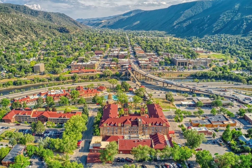
Downtown Glenwood Springs features numerous local shops, restaurants, and breweries. Additionally, visitors to Glenwood Springs can check out the Glenwood Canyon Adventure Park, which is an amusement park situated atop a nearby mountain that’s only accessible by cable car.
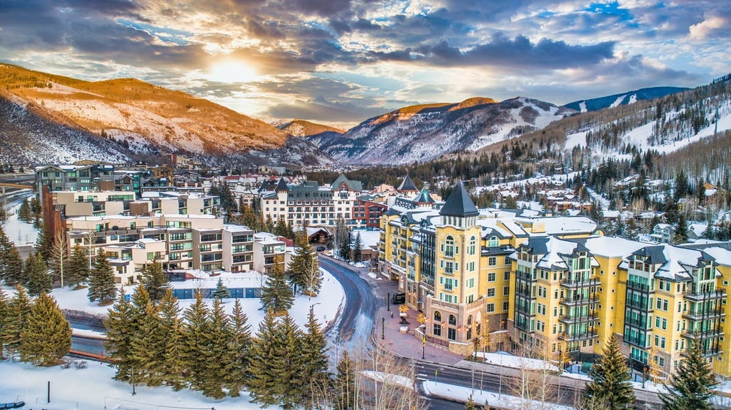
The town ofVail lies just southeast of the wilderness. It is known for its world-class skiing and fine dining. Home to around 5,000 residents, the resort town comes alive each season with visitors from around the world. Situated at the base of the Vail Ski Resort, the city boasts the largest collection of developed ski terrain in the state.
During the summer, the surrounding mountains transform from ski slopes into a network of hiking, mountain biking, trail running, and backpacking trails. The Lionshead Gondola offers views of the breathtaking landscape and small town.
Each year, the city hosts multiple events including the Burton US Open, Vail America Days, Bravo! Vail, and Vail Film Festival. During the summer months, the city also has a weekly farmers market that’s worth checking out.