
Scan the QR code and open PeakVisor on your phone
Kazakhstan is home to 5,553 named mountains. The highest is Khan Tengri at 6,995 m.
Kazakhstan hides in the very centre of mainland Eurasia, among the hot deserts and majestic mountains with snowy peaks. It is the ninth largest landlocked country in the world in terms of land area.
It is not for nothing that Kazakhstan is called the country of contrasts. Here you can find both
You name the natural opposites and you get them here almost 100%.

The name of the country consists of the Old Turkic word ‘kazak’ meaning ‘free’, which perfectly well describes the nomadic lifestyle of the local population, and the word ‘stan’. The latter element is very widespread in Central Asia and means "land, region, place, or country". Literally, the name Kazakhstan can be translated as ‘the land of free people’. Over time, the name "kazak" was replaced by "Kazakh" the last letter being changed so that there would be no confusion between the caste of the Cossacks aka Kazaks in Russian (the social stratum living in the South of Russia and Siberia) and the Kazakh people (the Kazakhs) per se.
Kazakhstan covers an area of 2,724,900 square kilometers, which is almost equivalent in size to Western Europe. As of June 01 2021, the country has a population of 18,984,845 people. The modern capital of Kazakhstan is the city of Nur-Sultan, until recently known as Astana.
Kazakhstan used to be a part of the Great Silk Road in the old days. Today, the country is capitalizing on that brand and implementing a project called the ‘New Silk Road’ which is meant to bridge the gap between Europe and Asia. To put it simply, Kazakhstan is trying to become the largest economy in Central Asia and the busiest transit region.
Kazakhstan is home to the Baikonur Cosmodrome (this is what they call a space force base in the former USSR states) which is being leased by Russia until 2050.

The country is located in two parts of the world, right on the border between Europe and Asia with most territory being situated in Central Asia.
There is some discrepancy in the sources as to the exact border between Europe and Asia. In the Soviet, Russian and Kazakh sources the border is passing through the Mugodzhar Mountains and the Emba River, whereas the CIA World Factbook defines the River Ural as the border between Europe and Asia. Yet, the best puzzle is presented by Encyclopaedia Britannica – its maps define the Ural River as the border whilst the description quotes the Mugodzhar Mountains and the Emba River to define the same concept.
Kazakhstan neighbors several states: Kyrgyzstan, Uzbekistan and Turkmenistan in the south, China in the east, and Russia in the north and west. The border with Russia is 7,591 km long and it is the longest uninterrupted land border in the world.
Kazakhstan extends north to south from the plains of Western Siberia to the deserts of Northern Asia and west to east from the Caspian Sea to the Altai Mountains.
The terrain is varied, but most of the territory consists of plains, low mountains and hills. There are 4,806 named mountains in Kazakhstan with Khan Tengri (6,995 m) being the highest point. The most important mountain is Belukha (4,506m). One third of Kazakhstan territory is occupied by the Kazakh Steppe (Plain), which is the largest dry steppe region in the world. The Kazakh Steppe is a part of the Great Steppe that runs along the entire Eurasia.
The northern part of the republic is located on the West Siberian Plain south of which rise the modest Kokshetau Mountains (Sinegorye).

To the east are the Altai and the Tarbagatai Mountains which are separated by Lake Zaisan.
From the southern to the eastern part of Kazakhstan, along the borders with Kyrgyzstan and China, rise the ridges of the northern Tien Shan Range.
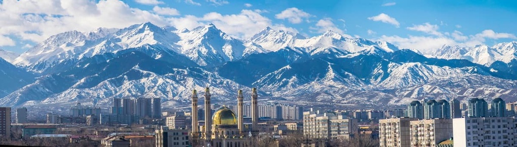
In the southeast of the country are the Dzungarian Alatau and Zailiisky Alatau Ranges. At the foot of the latter is the former capital of the republic and the largest city of Kazakhstan, Alma-Ata aka Almaty.
The western part of the country is covered by deserts and semi-deserts, here you can find the low Mugodzhar Mountains which are the southern continuation of the Ural Mountains. On the Mangyshlak Peninsula is the Karagiye (Batyr) Depression, one of the deepest depressions on land – the Karagiye (Batyr) Depression – is located on the Mangyshlak Peninsula. Karagiye is 132 m below sea level.
In the very center of Kazakhstan lies the Kazakh hillocky area. In Kazakh language it is called the Sary-Arka which means Yellow Steppe. It is a steppe with small but steep hills (hence the name hillocky). In the middle of it lies the capital city Nur-Sultan.
Despite its rather dry climate, Kazakhstan can boast of about 8.5 thousand rivers, some of which are navigable. Seven rivers are longer than 1,000km. They flow mainly on the outskirts of the region. Steppe rivers often dry up in the heat of summer. The main rivers are the Ily, Irtysh, Ishim, Ural, Tobol, Embu, and Syr Darya. The Irtysh and Nuru rivers are connected by the 500-km long Irtysh-Karaganda Canal.

Yet, it is the lakes that Kazakhstan takes special pride in. They are located mostly in the north of the country. There are 48 262 lakes in the region, many of them saline. 45 248 lakes are less than 1 sq.km. The largest body of water in the country is the Caspian Sea, which is technically also a lake. About a quarter of its water area belongs to Kazakhstan.
The second largest water basin in Kazakhstan is Lake Balkhash. The peculiarity of the lake is that half of its water is fresh, and the other half is salty.
The Aral Sea used to occupy the honorary second place, but due to the extensive use of its waters for many years by Uzbekistan and Kazakhstan for land irrigation, the Aral almost dried up. As a result, three reservoirs were formed. The northernmost of these is the Small Aral Sea, entirely located in Kazakhstan and fed by the waters of the Syr Darya River. A dam was created on it to prevent the overflow of water to the southern part located in Uzbekistan, which at some point in history caused much chagrin.
Other large lakes include Zaisan, Tenghiz, and Alakol lakes.
There are 13 large reservoirs in the country with a total area of 8816 sq.km. The biggest are: the Kapchagay, Shardara, and the Bukhtarma Reservoir.

The unique terrain and climatic diversity contributed to the richness of flora and fauna of Kazakhstan.
Due to the arid climate, 84% of the territory is occupied by dry lands (deserts take up 44%, semi-deserts – 14%, and steppes – 26%). Forests account for 5% only, most of them are located on the slopes of the Altai and the Tien Shan Mountains. The vegetation of the country is represented by about 6,000 plant species, 380 of which are included in the Red Book. Saksaul (Haloxylon), marsh rosemary, bearberry, gagea, sedge, and white locoweed (Oxytropis) are quite widespread. Rare species of plants include Kyrgyz birch, astragalus, calligonum, Transcaspian hawthorn, wild apple trees (Malus sieversii), wild grapes (Vitis vinifera), wild tulips (such as Tulipa greigii, Tulipa kaufmanniana), rare species of onions (Allium karataviense) and others.
Saksaul is a typical representative of the Kazakh flora. This tree-like shrub growing in the deserts has a curved trunk and a wide crown, it can reach up to 12 m in height. Camels love eating it all year round. Saksaul timber is very strong. This peculiarity gave it its second name – the iron tree. It is the only blooming tree in the republic that serves as a natural barrier to sandstorms.

Calligonum is another endemic desert plant. The prickly shrub has many branches which allow it to creep along the hot sand and stones, reaching a length ranging from 40 cm to 7 m. Calligonum is covered with small flowers in April and fruits come by the end of May, birds and camels like devouring them. Young shoots of calligonum are used to make tea which can quench your thirst perfectly fast. And yes, they drink hot drinks in the deserts to hydrate, not some cold water.
The steppes and deserts become blossoming fields covered with endemic Borshchov tulips (Tulipa borszczowii). By the way, this is a symbol of Baikonur Cosmodrome because these tulips grow in abundance in its vicinity. This tulip is a typical representative of the lily family; it was named after the Russian botanist Ilya Borschov. It blooms early and its beauty lasts only 12-14 days. This beautiful wild tulip is also very capricious and is not used in selection.
This is just a small part of Kazakhstan flora. Steppe and desert areas are mostly covered with grasses and shrubs, and mountain ranges enjoy lush vegetation. All plants are adapted to live in a dry climate.

The animal world of Kazakhstan includes 180 species of mammals, 52 species of reptiles, over 50,000 invertebrate species (insects, crustaceans, mollusks, worms), 12 species of amphibians, 500 species of birds, over 100 species of fish.
Mammals feature wolf, elk, corsac fox (Vulpes corsac), red fox, argali (the largest species of wild rams), manul cat, European lynx, iris. Some of them are protected by the state.
You can see saiga antelope (Saiga tatarica) in the Irgiz-Turgay Nature Reserve in the Aktobe Region.

Kazakhstan has a continental climate varying from moderate to sharply continental depending on the region. Annual precipitation on the plains is insignificant, most of it falls in spring and early summer. In July and August, the chance of rain is close to zero. However, this is not true about the mountains where precipitation occurs all year round. In the north of Kazakhstan, winters are long, snowy and frosty. To the south, winters are shorter and drier. Winter weather is rather changeable: the snow may melt fast and all the surfaces will be glaciated in a matter of hours. The average temperature of the coldest month (January) ranges from -19°C (-2F) in the northern regions to -5°C (23F) in the southern ones. Nur-Sultan is the second coldest capital in the world after Ulaanbaatar. Summers in the country are hot and dry. Average July temperature in the north of Kazakhstan is +17°C (63F), whilst in the south it usually exceeds +30°C (86F).
The ideal time to visit Nur-Sultan and Almaty is early and mid-autumn when it is not so hot and there is an abundance of fresh fruit and vegetables. The swimming season lasts from the end of May to mid-September. The mountains, on the other hand, are open all year round and require appropriate preparation and equipment depending on the time of year and the purpose of your visit.
Many people erroneously think that the nature of the country is just wide open spaces of steppe landscapes stretching as far as an eye can see. However, this is not the case. Picturesque mountains, canyons and gorges, lakes with pure turquoise water attract many travelers from different countries. Natural attractions are scattered in different parts of the large country, therefore, it is important to plan the route well in advance. Besides, many natural monuments can be reached only by car so plan accordingly. There are organized tours from major cities – Nur-Sultan or Almaty – to the most interesting places. The big lakes (Balkhash, Borovoye) feature quite developed tourist infrastructure, there are spas and resorts as well as good excursion programmes. Those who prefer the outdoors devoid of any human trace and like travelling on their own can sleep rough or in tents on the lakes and in the mountains.

The Tien Shan Range is not the only mountain range here. The most famous mountains systems in Kazakhstan are:
The Tien Shan and the Altai Mountains are undoubtedly the most popular among extreme climbers, mountaineers, and outdoor lovers. The lower mountain ranges are mostly unsuitable for high-altitude mountaineering, but here you can enjoy long trekking, rafting on mountain rivers, or exploring caves.
History and cultural monuments can be found in the cities of Shymkent (formerly called Chimkent) and Taraz (formerly called Jambul) located on the route of the Great Silk Road from China to Europe. Shymkent excursion programs include holy places revered by Muslims. In Taraz, you will have an opportunity to visit the Museum of History, Aishi-Bibi Mausoleum, and Sypatai Batyr Mausoleum.
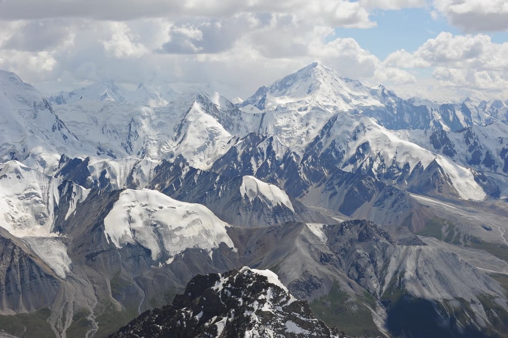
The greatest mountains in Kazakhstan are the Tien Shan whose name means Heavenly Mountains. Its highest point is Peak Pobedy (7, 439m) but it is located in Kyrgyzstan. Kazakhstan is home to almost the entire Northern Tien Shan, as well as parts of the Central and Western Tien Shan.

The Kazakh part of the Central Tien Shan starts from Khan-Tengri (6,995m) at the junction of the borders between Kazakhstan, China and Kyrgyzstan and then continues towards the west with a number of ranges, the largest of which is the Tersky Alatau. This range also serves as the eastern border between Kazakhstan and Kyrgyzstan.
The Terskey-Alatau Range aka Terskey-Ala-Too or as the locals have it "the motley mountains turned away from the sun" is mainly located in the north-eastern part of Kyrgyzstan and flanks the Issyk-Kul Lake basin from the south. Kazakhstan enjoys only a small part of its northern slopes. The range is asymmetrical with a short, gentle southern slope and a long northern one. The length of the range is about 375 km, it connects to the Kungey-Alatau Range in the east and adjoins the Sary-Dzhaz Range outside the Issyk-Kul Hollow. The average height of the range is about 4,500 m, the highest point reaches 5,216 m (Karakol Peak).
The Terskey-Ala-Too Range is the second largest center of glaciation in the Tien Shan; there are about 1,100 glaciers with a total area of 1,081 sq.km. Over half of them are found in the northern slopes facing Issyk-Kul Lake. Speaking of which, the northern slope of the Terskey-Alatau descends by giant steps to the 702-metre deep Issyk-Kul which lies at 1609 m a.s.l.
The highest and most frequently visited part of the Terskey-Alatau is the central one, between Barskaun and Turgen-Aksu gorges. Here lie the largest glaciers as well as the most technically difficult and diverse passes. Tourist routes often go not only along valleys and passes of the Terskey-Alatau, but also lead to Kumtor and Arabeli syrts (districts), cover Kuylu and Akshyirak mountain ranges.
The passes of the Terskey-Alatau Range vary from 3,600 to 4,800 m a.s.l. and have up to 3B categories of difficulty. The absolute majority of passes of the main range and its southern spurs are snow and snow-ice. Passes of the northern spurs of the range are more diverse, there are rock, ice, snow, and talus passes, and most often they are combined.
Planning routes in the Central Tien Shan, please beware the peculiarities of each season. In winter, the weather conditions on the southern slopes of the Terskey-Alatau, the Kuylu Ridge and the Akshyirak might be very harsh. The relief here creates conditions for stagnant and freezingly cold air. The long-term average of January-February temperature here is -28°C (-18F), the absolute minimum is -53.6°C (-65F).
If the route passes through the southern slopes of the Terskey-Alatau and crosses Kuylu and Akshyirak massifs, you need a special permit (the admission to the border zone) which should be applied for at the FSK agencies in your place of residence or in Almaty or Bishkek. Group travel permits must obligatory be registered in Karakol.

The Northern Tien Shan includes such ranges as the Zailiisky Alatau, Ketmen, Kungey Alatau, the Chu-Iliisky Mountains, and the Kyrgyz Alatau. Talgar Peak (4,979m) towers over the Zailiisky Alatau, it is the highest peak in the Northern Tien Shan. It would be difficult to climb this peak without special training and equipment, but you can admire its view from the cities of Alma-Ata and Talgar. Next to the mountain is the Korzhenevsky glacier. It is the largest glacier in Kazakhstan.

The Western Tien Shan within Kazakhstan begins south of the Kyrgyz Range, beyond the Talass Valley. Here, in the close vicinity of Taraz town, starts the Talass Alatau Range which in its Kazakh part has two ridges - the Zhabaglinsky Mountains and the Sayramsky Ridge. The Zhabagly or Zhabaglinsky Mountains are divided into two mountain ridges as well which form the Aksu-Zhabagly basin (the height of the northern ridge is 2,600-2,800 m, the height of the southern ridge is 3,500 m).
The Western Tien Shan includes the Talass Range with its southwestern spurs called the Ugam Ridge that continues on to Uzbekistan and the Korzhintau Ridge.
The Karatau Range is the most northern-western spur of the Tian Shan. Its slopes have been severely eroded over time. It extends in the north-western direction for 400 km, and its average height is 1,800m. The highest point is Mynzhylky (2,176 m). The Karatau is the only Tien Shan range that is totally located inside Kazakhstan.
The climate of the Western Tien Shan is influenced by the warm climatic conditions of southern Kazakhstan. Therefore, the snow line is higher than that in the east. The average annual amount of precipitation is also higher and amounts to 600-800 mm. On the slopes of the mountains, the average temperature in July is +20°+25°C (68-77F), at the foot of the glaciers -5°C (23F).
The second most popular mountains in Kazakhstan are the Altai. In Kazakhstan, the main Altai ridges are:

Belukha (4,506m) is the highest peak of the Altai Mountains and the highest peak of Siberia. Geographically, this mountain is about the same distance from the Arctic, Pacific and Indian oceans. The top of Mount Belukha is always covered with snow and ice, thus the name – white mountain.

It has two summits, the Eastern and the Western, the former being a bit higher than the latter. In 2002, two paragliders started synchronously from the Eastern summit (4,509m). Travelling by air is undoubtedly faster, but skier Dmitry Shchitov took up the challenge in 2003 and went downhill from the very top of Belukha in about 2 hours. Belukha is not a mountaineer-friendly mountain due to harsh weather conditions and the typically low atmospheric pressure, which at the top of the mountain is about half the normal. Moreover, the rocks on the slopes of Belukha are covered with a thin layer of leaky ice all year round, which makes them incredibly slippery. To add to the trouble, Belukha is located on a tectonic crease that generates earthquakes on a regular basis.
A famous Russian painter Nicholas Roerich made Belukha the star of several of his paintings.
On the Russian side, the mountain is located in the Altai Republic, and in Kazakhstan it is situated in the Katon-Karagandy Nature Park. The mountain is considered sacred both by Buddhists and Altai shamanists. It is considered to be one of the entrances to the mystical land of Shambala and the mysterious Belovodye (White Water Area). Modern esotericists and Roerich's followers consider the mountain a place of power and information pyramid that is receiving messages and energy from space.
The Altai people have many prohibitions associated with the sacred mountain. It is forbidden to make noise and loud sounds on the slopes of Belukha. Also, iron objects cannot be brought here, and hunting is not allowed in these places. As in many other sacred places in the Altai, women are not allowed to enter the lands of Belukha Mountain.
Once upon a time, there used to be a legend among the locals that everyone who dared to climb the top of Belukha, would go blind. It has a scientific justification as well – without special glasses the glow of light reflected from snow and ice can really damage the retina and impair vision.

The Karkaraly aka Karakalinskiye Mountains are rather low, they are a part of the Kazakh Hillocky area, their highest point is Komsomolsky Peak (1,403 m). Komsomolsky Peak is considered to be a part of Zhirensakal mountain in the southern part of the Karkaraly. Other high peaks include Shankoz (1,360 m) in the north, Koktobe (1,254 m) in the west, Myrzashoky (1,169 m) in the south-west, Akte Rek (1,230 m) in the south-east, Karkaraly (1,206 m) in the north-east. Mount Karkaraly with its serrated outline gave its name to the entire mountain range. There are also many lakes here: the Ulkenkol, Chertovo (Shaitankol), Pashennoye, Bassein, Kishikol, Shurykkol, etc.
Part of the territory occupied by the Karkaraly and Kent Mountains belongs to the Karkaraly National Park. You can go hiking in the mountains and forests on weekends, and they are perfect for people with any level of training.
This small mountain massif surrounds the town of Karkaralinsk, an old district town in the middle of the Kazakh steppe, 220 kilometers east from Karaganda.
Another low mountain range in Kazakhstan is the Deghelen. Located in the eastern part of the Kazakh Hillocky, it has a total area of 360 sq.km and some of its peaks barely exceed 1000 m in height. It is better known not for its heights, but for its belonging to Kurchatov town and Semipalatinsk nuclear test site. In Soviet times, there were nuclear explosion tests carried out here in the underground tunnels. Nowadays, the test site is closed and there is no access to the cavity formed as a result of the explosions.
Being called a smaller carbon copy or a younger brother of the Grand Canyon in America, the Charyn Canyon is located 200 km from Almaty. This gorge is about three kilometers long with rocks of unusual red and orange colour. You can move here only on foot. In the canyon, there is a grove of a relic species of ash – the Sogdian ash – which survived the Ice Age. Another similar grove exists only in North America. The height of the walls reaches 300 meters, and the age of the rocks is more than 12 million years. Surprisingly, the canyon is surrounded by endless steppe. You can be driving a car and then all of a sudden in the middle of the steppe comes a deep fault at the bottom of which is a winding road. Individual parts of the canyon are laden with various legends. The most popular tour is a visit to the Valley of the Canyon Castles.
The Tamshaly Canyon is located on the shore of the Caspian Sea, 5.1 km south of the Bagarshik Cape, 27.4 km northeast of Fort Shevchenko town. It stretches into the northern part of the Tupkaragan Peninsula as a huge fissure. The length of the canyon is 12 km. The wind-eroded rocks formed a peculiar giant bowl for the spring which turned into an unusual waterfall. In the winter, the water flowing down the rocks freezes thus forming icy cascades. In the deepest part of the gorge there is a lake with freshwater.
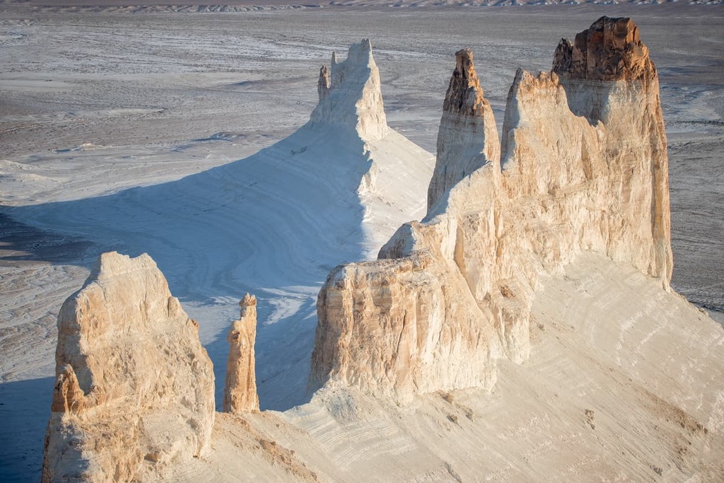
The Boszhira plot of land is basically a bunch of rock formations at the bottom of a large canyon in the western part of the Ustyurt plateau on the Mangyshlak Peninsula (300 km from Aktau). It is considered one of the most beautiful places in Kazakhstan. Its name was given by the Boszhira hill. In ancient times, this place was completely hidden by water being at the bottom of the sea. The cliffs here are formed by chalk and limestone strata as well as sandstone. Gazillions of years have passed since they were formed. During this time, they have acquired an interesting relief with unusual shapes. The local landscape is sometimes compared to the extraterrestrial and even called the tract the Kazakh Arizona, only white in color. At the entrance to the site, you will be met by two 200-metre high peaks – a kind of whimsical ‘fangs’ guarding the area. Here is also located Boszhira Mountain of a very modest height, just 287 m a.s.l. When hiking, you should be careful and watch out for scorpions found in abundance in the gorge.
Bektau-Ata site is located 70 kilometers from Balkhash town. The mountains rising in the middle of the steppe are quite an unusual and contrasting sight. The highest peak reaches 1,214 meters. These towers were formed as a result of a tectonic fault. There was no eruption per se, but the scientists claim that the volcano managed to melt the surrounding rocks. As a result, the volcanic lava solidified, forming pink granite rocks. Under the influence of weathering, the rocks acquired some bizarre shapes, for which they received unusual names – the Trunk, the Coffin, and the Turtle. There is also a real cave with a freshwater spring, which the locals believe is sacred and the water in it is therapeutic.

The Bayanaul Mountains might be rightfully called the most mysterious among all mountain ranges of Kazakhstan. Space-like, incredible, amazing, staggering, striking imagination – these are the words you often hear from travelers who visit the Bayanaul. The word Bayanaul is of Turkic origin, it can be translated as ‘happy, rich mountains’. The mountains look like a green oasis in the middle of the Kazakh steppes.
They are located on the left bank of the Irtysh River in the southwest of the Pavlodar Region of Kazakhstan. From the outside, it seems as if their slopes smoothly flow into each other. The mountain range is not very long and stretches from west to east for 40-50 km, and from north to south for 20-25 km. Mount Akbet (1,027m) is the highest point.
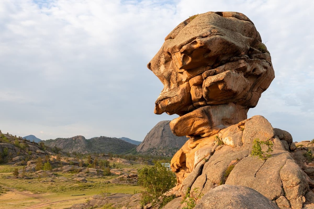
One can only wonder at the whimsical workings of Mother Nature who created such original and amazing sculptures of huge boulders. Many rocks have taken the form of an animal or even a man. There is Bun, Dove, Horse's head, a stone in the shape of a flying saucer and even the silhouette of the great Russian poet Alexander Pushkin.

One of the most favorite stones is Baba-Yaga Rock. In Kazakh language, the name sounds like kempir tas, which translates as ‘a stone head’. The boulder really does look like a grinning head of an old woman with a curved nose. The profile is much reminiscent of a well-known fairy tale character from Slavic folklore. The rock is located near Lake Zhasybai near the village of Bayanaul, in the Bayanaul National Park. You can get a guided tour to it. There are benches, a barrier, and a guard house near the rock.
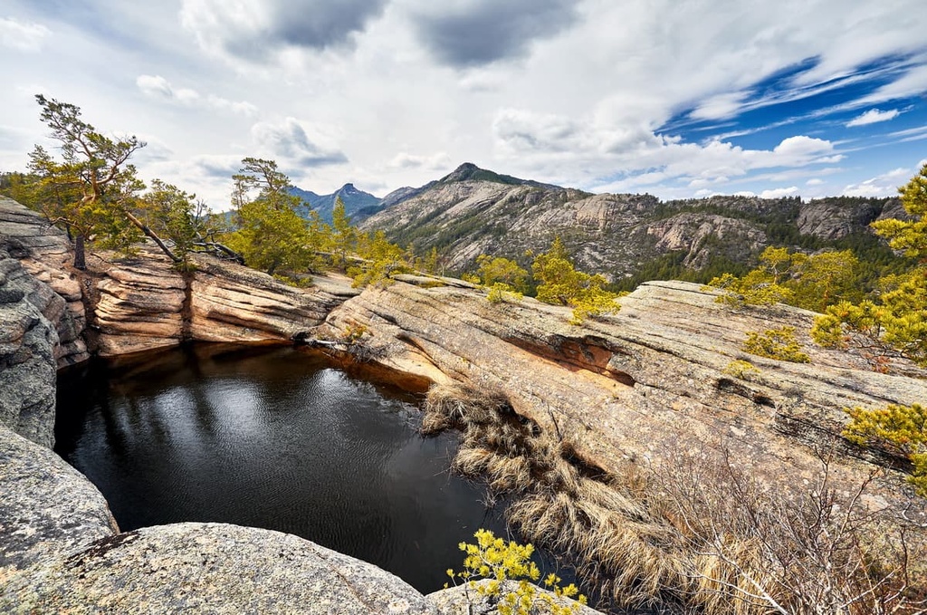
The Kokshetau Hillocky is located in the north of the country. It occupies the northwestern part of the huge Kazakh Hillocky. This low mountain ridge with projecting rocks has a length of 400 km, and its width reaches 200 km. The highest point of the hillocky is Mount Sinyukha (947 m). The mountain is the most popular in the area and is part of the Burabay (Borovoye) National Park. This part of the hillocky is also called the Kazakh Switzerland with plenty of options for great outdoor pastime.
The Kokshetau National Nature Park is also located in this part of the Kazakh Hillocky. It is home to the Aiyrtau Mountains and the beautiful Lake Shalkar. The lake's shores are picturesque, and you can meet all sorts of natural wonders there: the rounded boulders and granite stones, natural monuments such as the Stone Waterfall, Sharp Cone (Shishka) and Cracked Mountain, Two Brothers Cones, a huge gorge strewn with granites and many more.
The peculiar dune or as the locals call it barkhan is located in the corridor between the Dzhungarian Alatau Range and the Big and Small Kalkans Ridges on the territory of the Altyn Emel National Park in Alma-Aty Region of Kazakhstan, 183 km northeast of Almaty.
The Singing Dune is included into the list of the Seven Wonders of Kazakhstan. It is a 3-kilometer-long and 150-meter-high pile of sand. Due to the friction of the grains of sand against each other in dry weather you can hear the "singing" of the barkhan which resembles the sounds of an organ. In addition to the musical background, tourists are attracted by the picturesque panoramic views. The river, the mountains of amazing shades, the crests of sand - all this forms an unusual experience.

The Kazakh caves have underground lakes, stalactites, traces of primitive people and many unexplored passages and branches.
Skazka (Fairy-Tale) Cave is the deepest in Kazakhstan. It is located in the foothills of the Karatau Range in the south of the country, near Ak-Biik village, 12 km from Zhabagly village. In the old days, geologists were looking for gold in the local mountains, and for this purpose they dug a tunnel to a depth of 50 meters. It was at this depth that they discovered the underground kingdom: a labyrinthine karst caves covered in stalactites. Back in the day, the cave was still untouched and full of speleothem formations, which earned it the name Fairy Tale or Skazka. Speleologists have studied only 300 meters of its underground passages. In order not to get lost, tourists are advised not to go deeper. Unfortunately, because of its proximity to Shimkent (80 km) it has gradually been subjected to barbaric pillage and its appearance has ceased to resemble a fairy tale elf-like realm. For speleologists, the cave is an ideal training ground – there is water, a labyrinth and vertical walls to combat.

The Konyr-Aulie Cave is located in the Bayanaul Mountains, in Akkaragai Mountain to be exact. It is on the territory of the Bayanaul National Park in eastern Kazakhstan, 17 km northeast of village Bayanaul. The entrance is so narrow that only one person will squeeze through, but it gradually widens to 40 m. The depth is 120 m. There are wooden steps leading to the 5-metre deep underground lake.
According to popular beliefs, if you dive into the waters of the sacred lake, it will heal many diseases. This cave also used to be a hiding place and a perfect shelter for a whole village with all its citizens and cattle; they were hiding here during the Dzungarian invasion. The armies also used it as a hide-out. Thousands of Kazakh warriors would wait for the night in the cave to go behind enemy lines. This very cave is described in Mukhtar Auezov's novel "Abay's Way" and is also included in the list of 100 sacred objects of Kazakhstan. Interestingly, there are several more caves with the same name in the country (in Bayanaul and in the south of the country). There are legends that after the Great Flood, the descendants of the Prophet Nuh found shelter in these caves. Rumour has it that this cave is the burial site of Genghis Khan.
Ak-Mosque Cave is considered to be the most beautiful cave in the country. It is a perfect shooting set for amazing pictures. It is more than just a cave. This is a grotto with a wonderful garden growing inside. That coupled with flocks of birds flying near the entrance make a heavenly sight. Located in Baidibek District of Turkestan Region, it has a length of 254 m, and its vaults rise to 25 m. From the outside, the cave is inconspicuous, but once it used to house a mosque in which the local elders sometimes sought refuge. In ancient times, the cave also served as a shelter for the whole villages when people were trying to hide themselves and their cattle during the Dzungarian invasion.

The Balaoiyk Cave aka Balayuk was discovered relatively recently and was immediately called the "miracle of Ustyurt". It is located in the south-eastern part of the Ustyurt Plateau, near the border with the Republic of Uzbekistan, 52 km southeast of the Karynzharyk Depression and 350 km from Aktau. The cave is surrounded by a flat valley but it is very hard to spot the entrance which is located in a karst hollow 50m long and 7m deep. The 120-metre-deep cave was created by underground springs, and at the bottom there is an underground lake, the depth of which has never been measured.
The Ustyurt Plateau is full of similar karst caves.
Zhylagan-ata can be found in the Turkestan Region of southern Kazakhstan at the foot of the Karatau Range eastern slope. It is about 100 km from the city of Turkestan. The depth of the cave is 50 meters. It is popular among pilgrims for it is here that the rocks weep, hence another name this cave is known for is the Weeping Rock. The cave is basically a large grotto with an underground spring. Water begins to flow when a man with a pure soul and good intentions reads the Koran. Another thing connected with holy power is a popular belief that if a childless woman spends a night in the cave, it will bear a child soon after.
At the top of the mountain on the way to the cave, there is a well. On the stones around the cave, you can see some footprints of a large man. And to the right of the cave entrance there is a mausoleum. The entrance to the cave is situated 15 m above a small river of the same name.
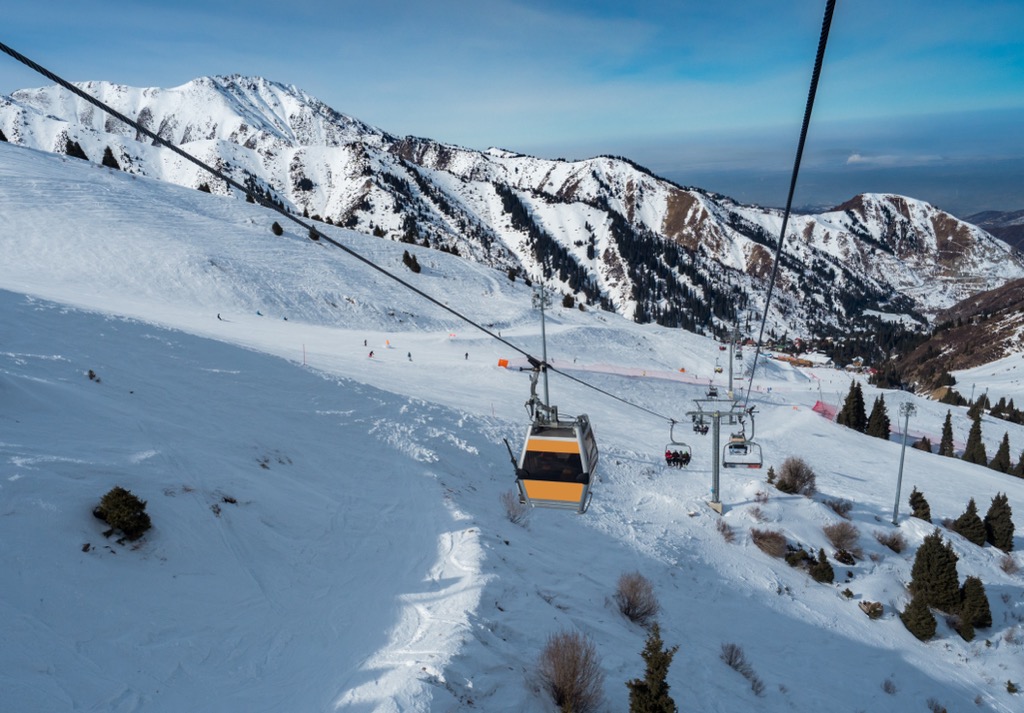
For skiing and snowboarding enthusiasts, there are 4 ski resorts in Kazakhstan, all of which are located less than 55 km (34 mi) to the east of its capital Almaty in the Zailiysky Alatau range. Some sports facilities in the mountains were established in the Soviet times and have been re-equipped to fit modern standards, others are brand-new and can satisfy even the most fastidious taste.
Shymbulak Ski Resort (Chimbulak), the largest in Kazakhstan, is located 35 km (22 mi) from Almaty with more than 20 km (12 mi) of slopes and more than 5 ski lifts. Good thing is, the skiing season here is long and doesn’t depend on weather conditions. Thanks to snow machines, you can ski here from November till April. The resort operates year-round offering visitors a lot of entertainment besides skiing: you are welcome to take guided tours in the mountains, or go downhill biking, paragliding, and hiking. There is a children’s camp and a rope park.
Tabagan Ski Resort is the second-largest winter sports and entertainment facility located 38 km (mi) from Almaty. It has more than 22 km (14 mi) of slopes and 4 ski lifts. In addition, the resort offers cross-country skiing tracks of 15 km (9 mi), horse riding, paragliding, paintball, or billiards. You can excel in your gun handling skills in a shooting gallery or train on a rock climbing wall. A huge park area called Yeti Park calls for long leisurely strolls. In the summertime, there is a soccer field for mini-football, a tennis court, a volleyball court, a trampoline, and a summer pool. That boosted by staggering views makes the Tabagan resort a must-visit destination point.

Oi-Qaragai Ski Resort also known as Lesnaya Skazka (Forest Fairytale in Russia) is the third largest resort in Kazakhstan with more than 15 km (9 mi) of slopes and more than 10 ski lifts. It is located just near the Shymbulak and Tabagan, and only 5 km (3 mi) further from the city. The resort also operates year-round. With fewer slopes, it is distinguished by its unique infrastructure, including a village in the trees, the largest yurt in the world, a unique trolley park, a rock climbing wall on natural mountain terrain, an ethnic-SPA also in traditional Kazakh yurts”, and much more.
Ak-Bulak Ski Resort is the fourth and farthest, 55 km (miles) from Almaty and 10 km (6 mi) from Talgar town. It has more than 10 km (6 mi) of slopes and more than 5 ski lifts. The slopes of the resort are located in the Zailiysky Alatau Gorge and are open to the public all year round. There is also an ice skating rink and a concert ground Ak-Aidyn, an equestrian complex called Tulpar where you can get some training, as well as a tennis court, a gym, a mini-football field, and boxing rings. Lovers of more relaxing pastimes can unwind in a SPA center with an indoor pool, and a VIP sauna, do some bowling, play billiards, and enjoy other entertainment. There is also a children’s health camp here.

Medeu Sports Arena is another place Kazakhstan is well-known for on the world’s winter sports map. It is not a ski resort but an ice skating rink, which is considered the highest and one of the largest winter sports facilities of this kind in the world. It is located on the mountain of the same name at an altitude of 1,691 m (5,547 ft), 27 km (17 mi) southeast of Almaty in the Medeu Valley. Figure skating, hockey, and speed skating competitions are held here but it is also open to the public all year round. There is access to the Shymbulak Ski Resort from the Medeu cable car station. But check out the availability of the cable car in advance, there might be closures.
Check the Kazakhstan ski resorts map in the World Mountain Lifts section of the site. It includes information about open ski lifts / slopes in Kazakhstan in real-time with opening dates and hours. There are also year-round cable cars, funiculars, cog railways, aerial tramways, and all other types of mountain lifts.
Kazakhstan has 10 nature reserves and 13 national parks which are home and a safe haven for many rare plants and animals that are on the brink of extinction.
The first five reserves in the list below are most frequented and popular among the tourists:

State National Nature Parks of Kazakhstan include the following:

The first two parks are the most visited. In addition, two more national parks – Merke and Ulytau – are planned to be established soon.
The Katon-Karagai State National Nature Park is the largest national park of Kazakhstan. It is located in the Katon-Karagai district of the East Kazakhstan region. Its area is 643,477 hectares. The park was founded in July 2001, and in 2014 it was included in the UNESCO list of specially protected heritage sites due to its attractions, landscape and diversity of flora and fauna. It is a very popular attraction among tourists from all over the world, with a huge number of tourist sites and tourist routes on its territory. The park is mountainous and glaciated, with altitudes often reaching over 3,000 m.
The park borders on the north by the Altai Republic of Russia, on the southeast by China, on the west by the Farpusnaya River, and on the south by the northern slopes of the Sarymsakty and Tarbagatai Ranges of the Southern Altai Mountains. 34% of the park is forested, the remainder being mountain meadows or rocky slopes and glaciers. The slopes are steep, with terrain formed by the glaciers: trough-shaped valleys, cirques, and moraines.The glacier-fed rivers are steep and energetic. The Kokkol Falls, at 80 meters, is the largest waterfall in the Altai Mountains. The nearest Railway Station is Zyryanovsk or you can get here taking Ust-Kamenogorsk - Zyryanovsk highway.

Lake Balkhash is a unique natural phenomenon in the east of Kazakhstan. The water in the eastern part of the lake is salty, whereas the salinity of the western part is so small that the water is almost fresh. This also conditions the fish and water plants living in the lake. Despite its large area, the lake is not that deep.
In the vicinity of the towns (Balkhash, Priozersk) near the lake, there is a developed tourist infrastructure. However, despite the many amenities, camping is still the most popular type of outdoor activities here. Warm water, large sandy beaches and hot summer contribute to it.

Before 1963, Lake Issyk used to be the most popular resort in the country. Yet, a massive 1963 mudslide devastated the entire lake and destroyed the dam as well. After the restoration works, the former volume of the lake almost recovered. The quiet surroundings and proximity to nature continue to attract tourists here. The colour of the water in the lake is amazing and changes depending on the weather from gray to blue to green.
1911 was rich in devastating natural disasters. One was the reason for forming 505-metre deep Lake Sarez in Tajikistan, the deepest lake in the Pamir. Back then a 9-point earthquake caused a landslide and blocked the Murghab River, thus creating a rocky dam over half a kilometer high. The water flooded the village of Sarez overnight, which gave the name to the lake. It took 37 years to fill the basin of the lake that now spreads over 70 km and has a total area of 17 sq.km.
An earthquake in 1911 in the Kazakhstan part of the Kungey Alatau Mountains formed Lake Kaindy. The ensuing landslide blocked the river gorge and made it fill with water in no time. The gorge used to have a pine forest which was submerged in water, yet not completely. You can still see the bare trunks of tall pines rising from the turquoise blue water. That is why this surreal place is often called the Sunken Forest. As to the name Kaindy, in Kazakh language it means ‘abundance of birches’. Truth be told, there is a charming birch grove just 5 km away from the lake. Nowadays, the lake is especially popular with divers. By the way, fish are not found in the lake despite the fact that the water is very clean.
Lake Kaindy is located 280 km from Almaty, at an altitude of 1,667 m. In the late 1980s, the area of the lake decreased after a mudslide flood. In February 2007, a decree was passed to create a national park, the territory of which includes Lake Kaindy.

Lake Borovoye is located on the territory of Burabay National Park. The shores on the eastern side of the lake are sandy, while on the other sides they are rocky. There is a popular water trip to Zhumbaktas Island (Sphinx) in the Blue Bay of the lake. The island really is shaped like a stately Egyptian sphinx. The water in the lake is clean, transparent, and considered therapeutic.

The Burkhan Bulak waterfall is located in the Dzhungarian Alatau mountains in the Kora River gorge which is 50 km from Tekeli town of, and 130 km from Taldykorgan town. The waterfall is 168m high and with its four cascades, it is the highest in Kazakhstan. However, tourists can see only three cascades, which is about 114 m. To get to the waterfall, you need to overcome a fairly dangerous mountain road. Because of the complexity of the route, most of the organized tours take three days. The Burkhan Bulak Gorge and waterfall are considered sacred, and there are many beautiful legends about them.

Citizens of the CIS member states (the countries belonging to the former USSR) do not require a visa to enter Kazakhstan.
You have to declare the foreign currency at the customs when you enter and leave Kazakhstan. Imported currency must not exceed $500, and when you are leaving the country, the amount of currency must not exceed the imported sum.
The export of gold, precious stones, rare minerals, as well as animals and birds is prohibited.
The duty free import of the following products is restricted: tobacco, cigarettes, and drinks containing alcohol. The maximum allowable ratios are 1,000 cigarettes, 1 kg of tobacco, two liters of alcoholic beverages.
The import of literature and other products that undermine the foundations of the state system or the norms of Islam is prohibited.
Nur-Sultan City, formerly known as Astana, is the youngest capital in the world. It is a little more than 20 years old. It was endowed with the capital status in 1997. It was called Akmola then, and a year later it was named Astana. In 2021, it was renamed again as Nur-Sultan in honor of the first president of the country Nursultan Nazarbayev.
Moving the capital has helped the country achieve economic growth and prosperity. Unlike the former capital of Kazakhstan, Alma-Aty, Nur-Sultan is located in the northern part of the country and has a more favorable geographical location.
Being a young city, the capital cannot boast of historically valuable sights, but it can rightfully brag about its modern ambitious architectural designs. Most of the architectural masterpieces here were created in the early 21st century. The project of creating a totally new city was initiated by Kazakhstan's President Nursultan Nazarbayev who insisted on every building in the capital having some unique deep meaning.

Water Green Boulevard features the highest concentration of the city's best architectural monuments. The boulevard was designed by a Japanese architect. The place is known for its many futuristic monuments, recreational areas popular with locals, and the main pedestrian precinct in the city. There are main government buildings here.
The city is easily recognized by the bizarre monument called Baiterek. Basically, it is a golden ball put in a crown-shaped frame. It towers above the city at a height of 105 m. The monument symbolizes the tree of life. Inside the golden ball there is a bar and an observation deck.
One of the most important landmarks of the city is Nur-Astana Mosque built in 2005. The mosque looks beautiful and majestic. An imposing golden dome and four towering minarets adorn it.
Another symbolic building is the Palace of Peace and Harmony. The pyramid-shaped building, the top of which is decorated with stained-glass windows depicting doves, was built for official meetings with representatives of various states. There are negotiation rooms and a beautiful hall for official celebrations.
Culture-vultures will find lots of options here as well. The capital's theaters and museums are open to the public at any time of the year. You can plunge into the local history and study the customs and traditions as well as art when visiting the National Museum of the Republic of Kazakhstan.
The most convenient way to visit Nur-Sultan is by air. There is Nursultan Nazarbayev International Airport formerly called Astana International Airport just within the city limits, about 17 km from the center. The airport operates direct domestic and international flights to the CIS countries as well as to European and Asian countries. It is also possible to enter Kazakhstan by rail.
The city of Alma-Aty or Almaty or formerly called Alma-Ata is located in the southern part of Kazakhstan, in the foothills of the Zailiisky Alatau Range. It came into being in 1854 as a military fortification called Verny (Faithful). In 1921, the city acquired a new name – Alma-Ata – after the name of the area where it was located (Almaty). In 1929, it got the status of the capital. For almost 70 years Alma-Ata was the capital of Kazakhstan, giving up this role to Astana in 1997.

The city is surrounded by mountain ranges and has a long history, so it can boast of many historical and cultural sites.
Located in the main square, the Monument of Independence is one of the most important symbols of the city. It is a 28-meter high stele on top of which is a 6-meter high figure of the ruler better known as the golden man. The main square of the city was built for public events and celebrations. It also hosts the House of Government (Akimat) and the residence of the head of state.
The Central Mosque is decorated with a golden central dome and a 47-meter-tall minaret.
Built in the early 20th century, the Holy Ascension Cathedral is the main Orthodox church in the city. The wooden temple is topped with five small domes and its facade is painted in delicate shades of yellow and beige.
Not far from the city is Kok Tobe Mountain (1,130m) whose name means Blue Hill. There is a park on top of it. It is a favorite vacation spot for the locals and the guests of the city. You can get to the top by cable car. The length of the ride is 1,620 m. The ride takes about 6 minutes, but the experience will last for years. Another unique feature of the mountain is the location of one of the largest television towers in the world. Its height is 371 meters. It has an observation desk half way up at a height of 176 meters. There are also many cozy cafes and restaurants on Kok-Tobe Mountain.

The most beautiful place in the vicinity of the city is Big Almaty Lake snuggly nestled between the mountain slopes and surrounded by coniferous forests. The color of the water in the lake is striking and varies depending on the season. There is a large highway from Almaty to the lake.
There is vibrant social and cultural life here, you are welcome to visit theaters, cinemas, concert halls, monuments and museums. There is a circus and a zoo in Almaty.
The fastest and most convenient way to get to the city is by plane. Almaty International Airport is located just 15 minutes from the city center. Or opt for a train if you are a tad aerophobic.

Ust-Kamenogorsk has a long history starting in August 1720 when the expedition of Ivan M. Likharev arrived in the area. Ust-Kamenogorsk is located in the eastern part of modern Kazakhstan, at the confluence of the Ulba River into the Irtysh River, about 280 km west of Belukha Mountain. This area of the Altai Mountain System is historically called the Ore Altai. Ust-Kamenogorsk is a starting point for traveling through the Altai Mountains.
Major landmarks feature:
Give us a shout about your fantastic adventures in Kazakhstan. We appreciate you sharing interesting insights and discoveries.


ultra
snow-leopard-award
china-ultras
kyrgyzstan-ultras
kazakhstan-ultras
ultra
snow-leopard-award
china-ultras
kyrgyzstan-ultras
kazakhstan-ultras
Yes. Kazakhstan has 5,553 named mountains. The highest is Khan Tengri at 6,995 m.
The highest mountain in Kazakhstan is Khan Tengri, at 6,995 m.
Kazakhstan has 5,553 named mountains.


