
Share

Scan the QR code and open PeakVisor on your phone
Scan the QR code and open PeakVisor on your phone
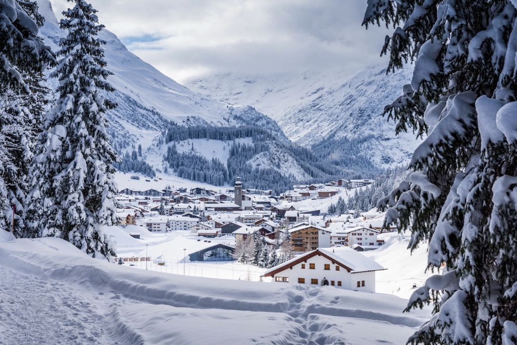
The Lechquellen Mountains (Lechquellengebirge in German) are a small range of 193 named peaks. The range is located in western Austria in Vorarlberg, which is neighbored by other small ranges like the Lechtal Alps and the Bregenzerwald Mountains. Große Wildgrubenspitze (2,753 m / 9,032 ft) (also called Untere Wildgrubenspitze) is the tallest and most prominent (980 m / 3,215 ft) mountain.
The Lechquellen Mountains are part of the North Tyrol Limestone Alps and are neighbored by ranges such as the Lechtal Alps and the Bregenzerwald Mountains. The mountains get their name from the Lech River, whose source is a watershed between the Rhine to the west and the Danube to the north. A well-known hiking route, the Lechweg, follows the Lech River for about 125 km (78 mi) from Lake Formarinsee in Lech am Arlberg, Austria, to the Allgäu region in Germany.
One of the range’s most famous features is the skiing at Lech and Zürs. World-renowned Lech am Alberg is the largest ski complex in Austria, connecting numerous slopes and circuits via cable cars. Lech is home to the steepest ski slope in Austria, as well as vast tracks of Austria’s only true big mountain, lift-access ski terrain.

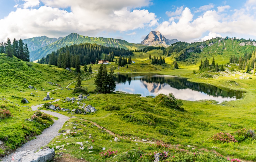
The summer season boasts incredible wildflowers, lush meadows, clear lakes, and rugged peaks. Rather than skiing, hiking and mountain biking are the primary vessels of recreation. The region has a long history of alpine farming, and hikers will likely encounter cows and the sound of cow bells along the trails.
The UNESCO Großwalsertal Biosphere Reserve partially overlaps with the Lechquellen Mountains. Gadental and Faludriga Nova are two core zones of the mountain reserve. Gadental and Bergwälder Klostertal are two Natura-2000 protected zones.
The Lechqeullen Mountains are part of the North Tyrol Limestone Alps and the greater Alp system. The mountains are composed of limestone, dolomite, and other sedimentary rocks and contain many karst formations, such as the gypsum karst dolines of Oberlech.
The Alps formed during the Alpine orogeny. This mountain-building event occurred as the African and Eurasian plates collided and has been ongoing since Cretaceous times. Most mountain building occurred between 65 and 2.5 million years ago, although the mountains continue to be uplifted. However, the uplift rate no longer outpaces erosion, and the Alps are not considered a growing range. Additionally, geologists have attributed the recent uplift to a rebounding effect as the Alps spring back after the weight of the last ice age’s ice sheet melts away.
Glaciers and glacial erosion played a significant role in shaping the Lechquellen Mountains. Due to their high elevation and precipitation, ice sheets formed early and disappeared relatively late. Glaciers and waterways carved out valleys, with a few glacial moraines. Today, only tiny remnants of the glaciers remain at high elevations, if at all.
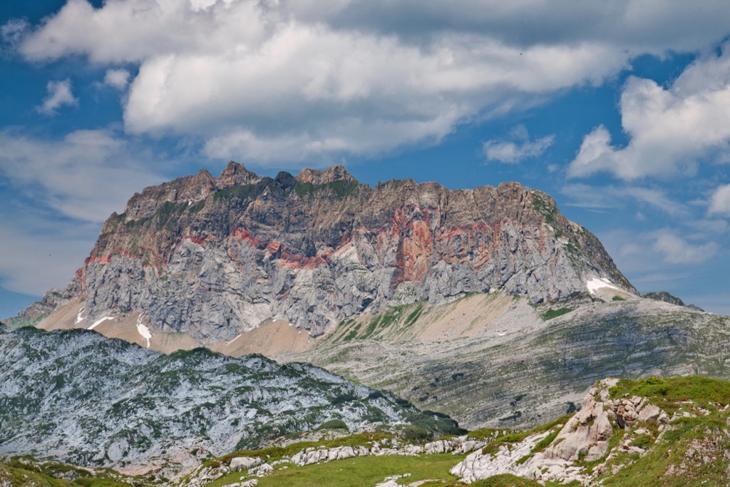
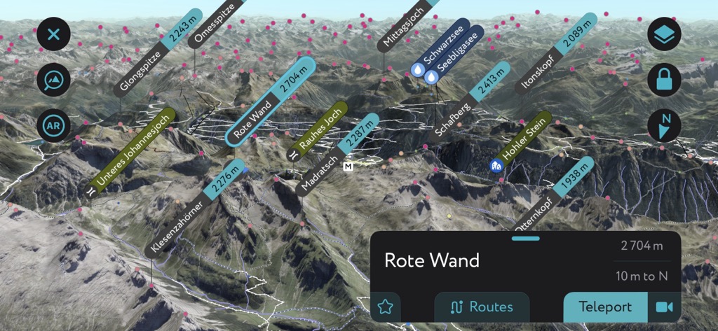
Rote Wand is another exciting feature and popular destination (2,704 m / 8,871 ft). Meaning “red wall,” a band of red limestone wraps around the towering mountain and is particularly pronounced on the south face. The mountain is bordered by Großes Walsertal in the north and Dallass (Monastery Valley) to the south.

The jagged Lechquellen mountains receive abundant rain and snow, contributing to some of the range’s classic traits – its fame for skiing in the winter and lush mountain meadows and rich wildflower bloom in summer. In addition to meadows, the forests contain various species of pine, fir, and spruce.
Like most European alpine communities, the region has a history of alpine haying and cattle grazing dating back centuries. Visitors should know that cattle, particularly mothers with calves, can be dangerous if provoked. Give cows a wide berth to avoid trouble. Mountain herding dogs can also be aggressive; it’s important to show deference to them on the trail (no eye contact or sudden movement, give them a berth), and you’ll be fine.
A number of classic Alp wildlife species reside in the Lechquellen Mountains. These include the ibex, an alpine goat; chamois, another nimble mountain ungulate; marmots, foxes, deer, hares, and various small mammals. Birdlife includes eagles, owls, woodpeckers, and sandpipers.
The Großwalsertal Biosphere Reserve covers 19,200 ha (47,444 acres). A portion of this falls within the Lechquellen slopes. Of particular note are the mountain meadows bursting with wildflowers, herbs, and numerous species of gentian and orchids.
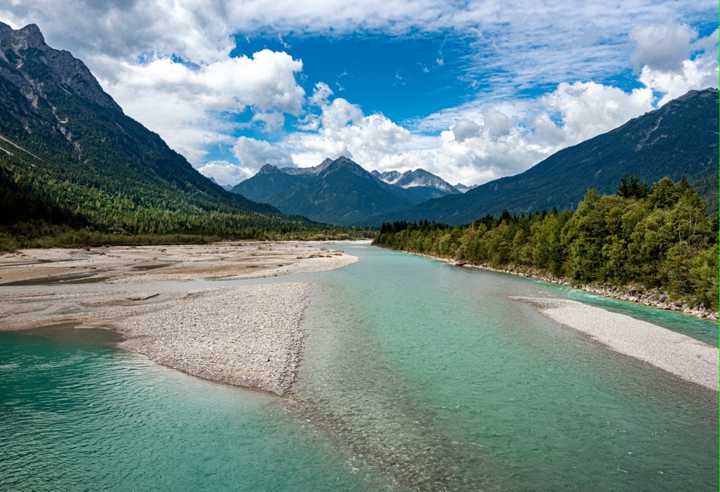
The Lech River is the last river of the Northern Alps that remains essentially unmodified. The river flows along gravel beds, up to 100 m (328 ft) wide in some spots, that provide essential habitat for species such as the endangered dragonfly Coenagrion hylas, the pink-winged grasshopper, the little winged plover, and plants like the German tamarisk.

Humans have lived in mountain valleys around the Lechquellen mountains for centuries. Six villages currently occupy the valley of Großwalsertal. The Walser people have settled here since the 14th and 15th centuries. The region has a long history of mountain farming, pasture management, and forestry systems. During the early 1500s, the Habsburgs took over most of the Vorarlberg and Tirol states. Vorarlberg stayed connected with Tirol until 1918, when it became its own state.
Lech am Arlberg, world-renowned for its alpine skiing, began its rise to fame around 150 years ago. The Arlberg railway tunnel opened in 1884, inaugurated by Emperor Franz Joseph I and ushering in the first guests to the area. In 1885, a Norwegian engineer coming to assess the railway brought skis and was the first to take advantage of the slopes. Ski Club Arlberg opened in 1904, the first race occurred in 1904, and the first ski school opened in 1921.
Films such as “Der Weiße Rausch” helped spread the resort’s name outside the Alps. The first lifts and cable cars arrived in the 1930s. Today, the ski complex continues to expand its cable car network and resort offerings.

The Lechquellen Mountains are a small range but offer day hike trails, multi-day treks, mountain biking, and, naturally, world-class skiing. The ski areas at Zürs and Lech are part of a larger ski complex in Arlberg and are considered one of the epicenters of alpine skiing. Many longer treks cross through the mountains with pit stops at alpine huts and refuges. There is an abundance of shorter day hikes in every village, Warth-Schröken and Damüls-Mellau being prime examples.

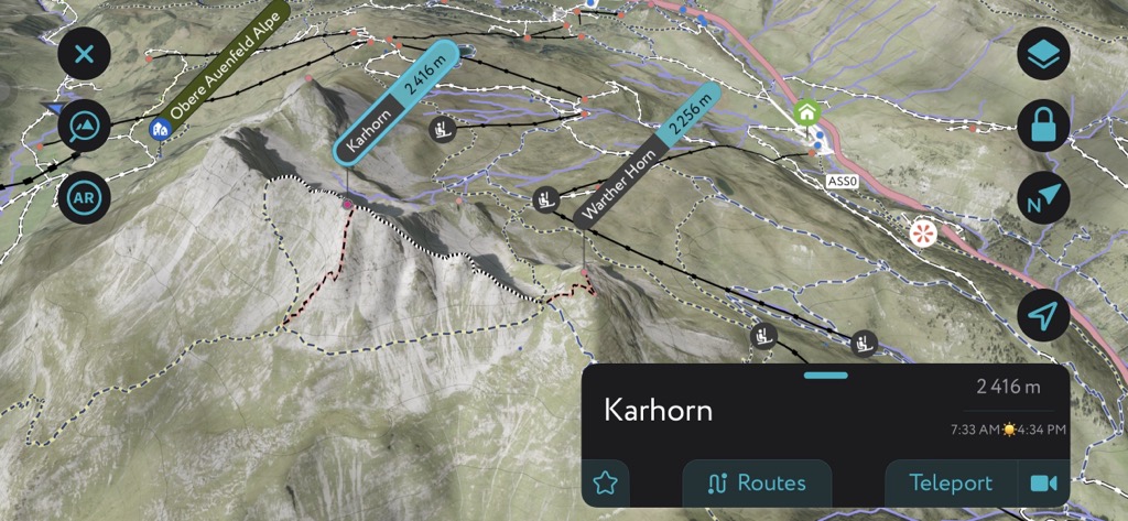
There are also via ferratas, aided climbing routes protected with fixtures like railings, cables, and ladders. The name means “iron way” in Italian; these routes originated as a way for soldiers to pass through mountainous terrain. One such route is the Karhorn Via Ferrata near Warth, a relatively straightforward but incredibly scenic route suitable for beginners. Most via ferratas are not fleeting affairs; this one takes over three hours to complete.

Those heading to the mountains in warmer months should watch out for afternoon thunderstorms. Snow can remain at higher elevations well into July, and snow storms can occur during any month of the year. Many huts are scattered throughout the peaks, with restaurants throughout the lift-serviced network and beyond.

Ski resorts at Zürs and Lech in the Lechquellen mountains are part of the Arlberg ski complex, considered one of the top alpine skiing destinations in the world. Arlberg exists where the Verwall Group, Lechquellen Mountains, and Lechtal Alps meet. Langer Zug has one of the steepest ski routes in Austria, and visitors have the option to heli-ski at Mehlsack and Schneetäli. Meanwhile, plenty of easy and moderate slopes are also peppered throughout the resort.

One of the famous ski circuits is the White Ring. It connects Lech with Zürs, Zug, and Oberlech. The route takes half a day and covers 22 km (13.5 mi) with around 5,500 m (18,045 ft) of altitude change. Slopes are rated easy to moderate. Although skiers can enter from most ski runs in Lech and Zürs, four marked entry points are most straightforward: Lech, Seekopf, and Zürserseebahn in Zürs, and Zugerbergbahn in Zug.
You’ll find two viewing platforms along the circuit. Rüfikopf offers stunning panoramic views of surrounding peaks, and the natural platform at Madloch looks out across Zug and Lech.

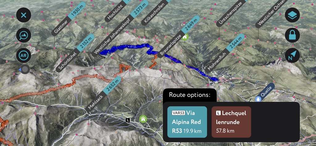
The Lechweg Trail is over 125 km (78 mi) and follows the Lech River. It begins near the river’s source near Lake Formarinsee in Lech am Arlberg and ends near the Lechfall waterfall in Füssen in the Allgäu region of Germany. The trail is a beautiful route through wilderness that lets hikers enjoy this untamed and natural river and does not require alpine experience.
The hike to the top of Rote Wand is for experienced hikers only. Those hoping to summit the range’s second-tallest peak can expect a seven-hour day. The well-trodden route goes from Lech over Formarinalpe and the upper Laguzalpe along the ridge to the summit. It finishes with a hike around Lake Formarinsee. As this mountain towers over its neighbors, views from the top are expansive. One can spot the Münster in Ulm on a clear day, about 135 km (85 mi) away.
The Freiburger Hütte is nearby and a popular stop-over for a warm meal after a long hike. Those who don’t wish to climb can enjoy the “Red Wall” mountain from the base.

Lech am Arlberg is one of the best spots to stay in the Lechquellen Mountains. A posh collection of ski resorts in the winter, the town and mountains are comparatively quiet but incredibly picturesque in the summer.
There are smaller villages tucked in the mountains, such as Bregenz village on Pfänder Mountain, which hosts the Bregenzer music festival each year on the banks of Lake Constance. International visitors can access the region from larger urban centers like Innsbruck and Zurich, Switzerland.
Lech is a mountain village with a year-round population of around 1,600 people. However, don’t be fooled; with exclusive ski resorts coming to life during the winter, visitor numbers are exponentially higher. Due to this town’s popularity, expect to pay hefty fees and book accommodation in advance. Despite the price tag, some lodging may not be available to book online and requires a phone call or email to arrange.
Cable cars provide access to the slopes in winter and hiking in summer. Restaurants and bars abound, and those who don’t want to hike or ski can enjoy the scenic restaurants at the top of the cable cars and ski lifts.
Lech suits intermediate skiers, while the nearby St. Anton offers more challenging slopes. This small mountain town is 2.5 hours by car from Zurich, Switzerland, and 1.5 hours from Innsbruck.
With a population of over 310,000 people, Innsbruck is an excellent destination for culture, nature, and proximity to mountain sports. It is the second-largest city in the Alps, after Grenoble, France, but arguably offers better mountain access. The city lies in a valley with steep mountains rising steeply around it; cable cars like the Nordkette and Patscherkofel provide quick access to the slopes for hiking, skiing, mountain biking, and paragliding.
Visitors can stroll through Old Town or pay a few Euros to climb the Town Tower. The Hofkirche church has 28 bronze statues, while the Cathedral of St. James showcases Baroque architecture. The Schloss fortress, a medieval fortress turned Renaissance castle for Archduke Ferdinand II’s wife, displays armor and artwork. Innsbruck hosted the Winter Olympics in 1964 and 1976 and the 1984 and ‘88 Winter Paralympics; the stadiums still host sports events.
Purchasing an Innsbruck Card is a worthwhile investment if you want to go to multiple museums, ride some cable cars, and have free transport on buses, trams, and bikes. The passes can be purchased for 24, 48, or 72 hours.
Innsbruck is within a 30-minute drive from both Italy and Germany. It is possible to arrive by train from Venice, Munich, Salzburg, and Zurich. The city also has a small but busy international airport and is a launching point for the famous Tyrolian ski resorts.

Zurich has a population of a little over 400,000 and is the largest city in Switzerland. It is undeniably a pricey city (like the rest of Switzerland) but with historic neighborhoods, a robust arts and nightlife scene, snow-capped mountains, and beautiful lakes. It’s not hard to see why Zurich is a centerpiece of the global elite.
Altstadt is the Old Town, running along the Limmat River and filled with shops, cafes, and historic buildings. The Old Town's crown jewel is the Grossmünster, an old Romanesque cathedral that guests can climb for panoramic views over the city, the Alps, and Lake Zurich. Other notable historic sites include the Lindenhof Plaza and the 9th-century church Fraumunster.
Lake Zurich is an easy escape from the city, with options for lakeside strolls, a refreshing swim, or a lake cruise. Hike, bike, or take the train up to Uetliberg Mountain. In the winter, hiking trails turn into tobogganing runs.
Zürich has several museums, including top-notch art museums like Kunsthaus Zurich and Rietberg. Those looking to make the most of their time may find it worthwhile to get a Zurich Card that covers unlimited public transport and free or discounted access to museums and activities.


Explore Lechquellen Mountains with the PeakVisor 3D Map and identify its summits.


