
Scan the QR code and open PeakVisor on your phone
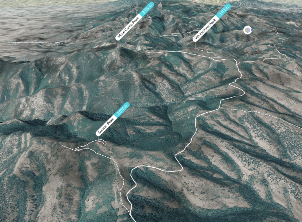
The Pavan Range include 31 named peaks. The highest is Mine Camp Peak at 3,116 m. Other notable peaks include White Pine Peak, Pioneer Peak and Sunset Peak.
The Pahvant Range, also known as the Pavan Range, is a mountain range situated in the central region of Utah. The terrain features forested hills and red rocky canyons. There are 31 named mountains in the range. Mine Camp Peak is the tallest and most prominent peak in the range at 10,223 ft (3,116 m) tall with 3,028 ft (923 m) or prominence.
The Pahvant Range lies in central Utah, running in a north-to-south direction for roughly 40 miles (64 km) in length and 15 miles (24 km) in width. The entire range lies within Fishlake National Forest, which spans 1.46 million acres (590,000 ha).

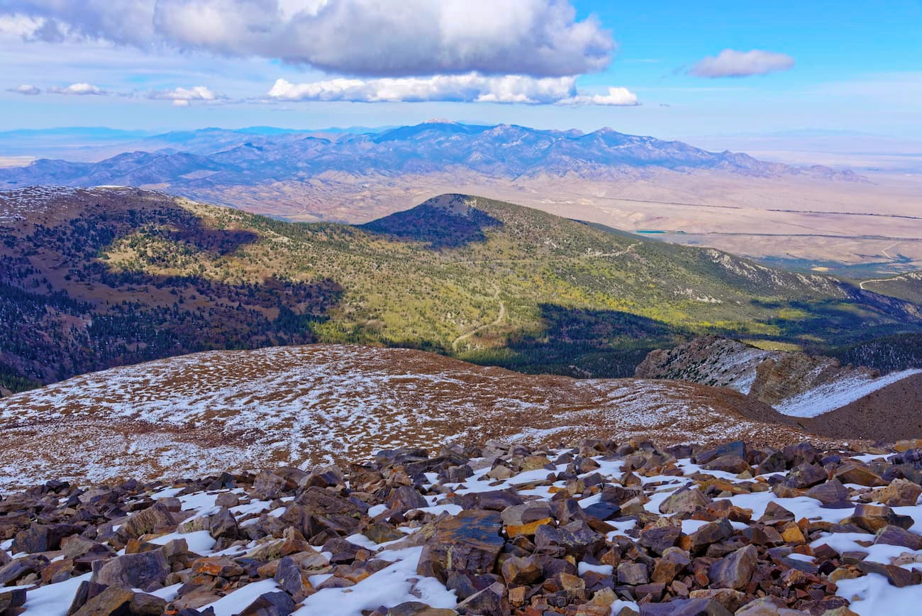
Peaks in the range mark the eastern edge of the Basin and Range Province. Elevations are lower in the southern portion with the tallest peaks, including Mine Camp Peak, being located in the northern section.
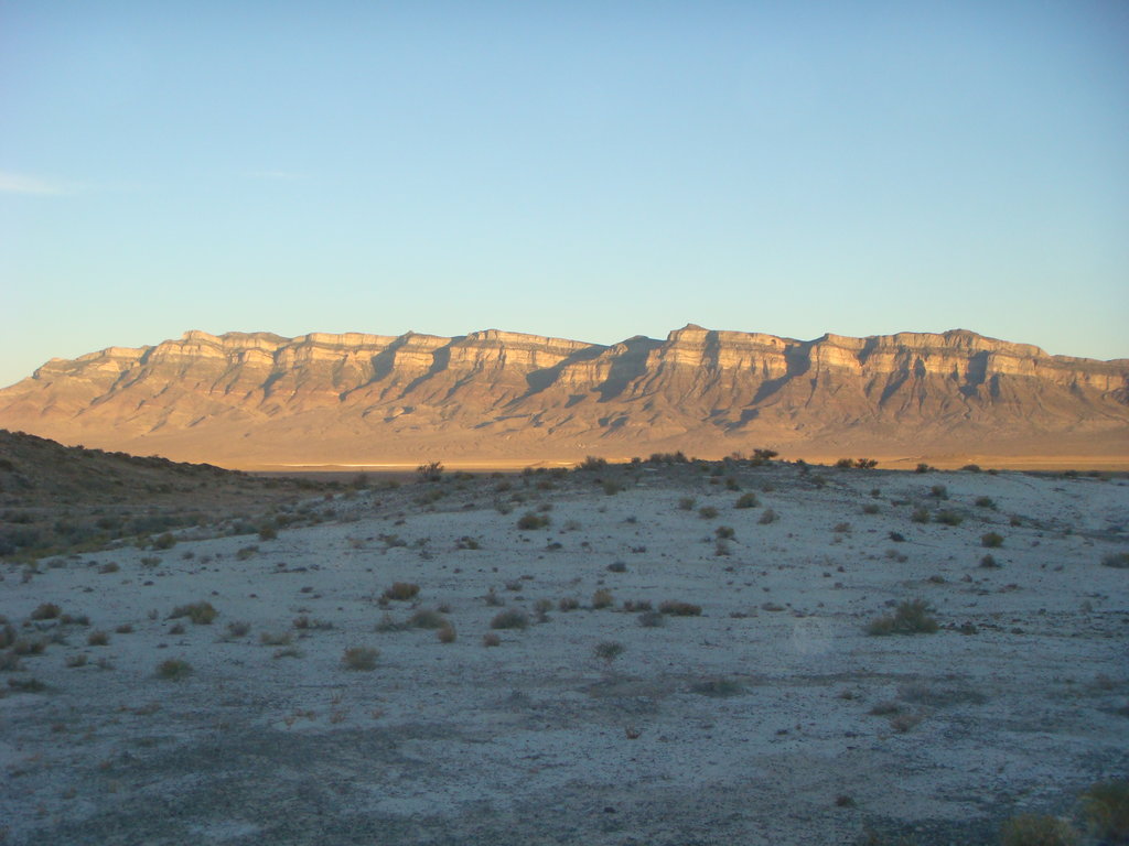
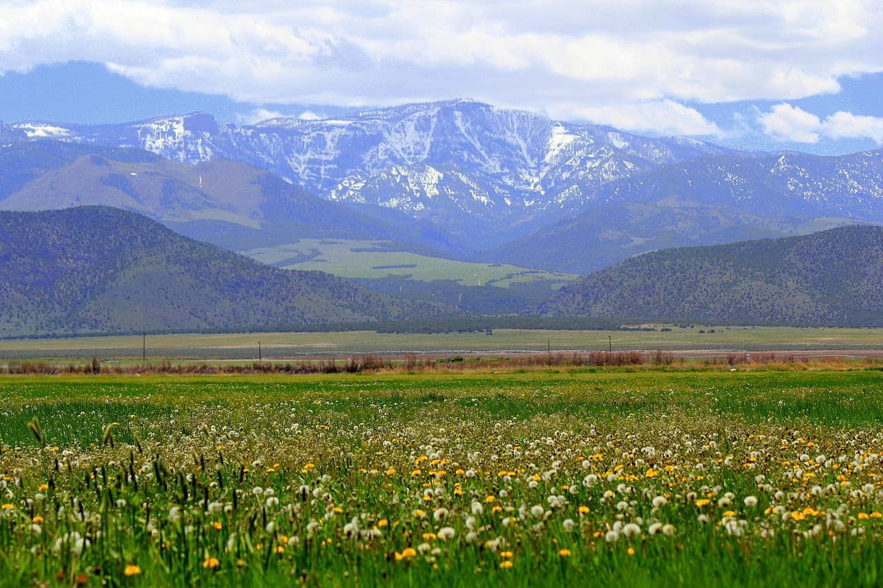
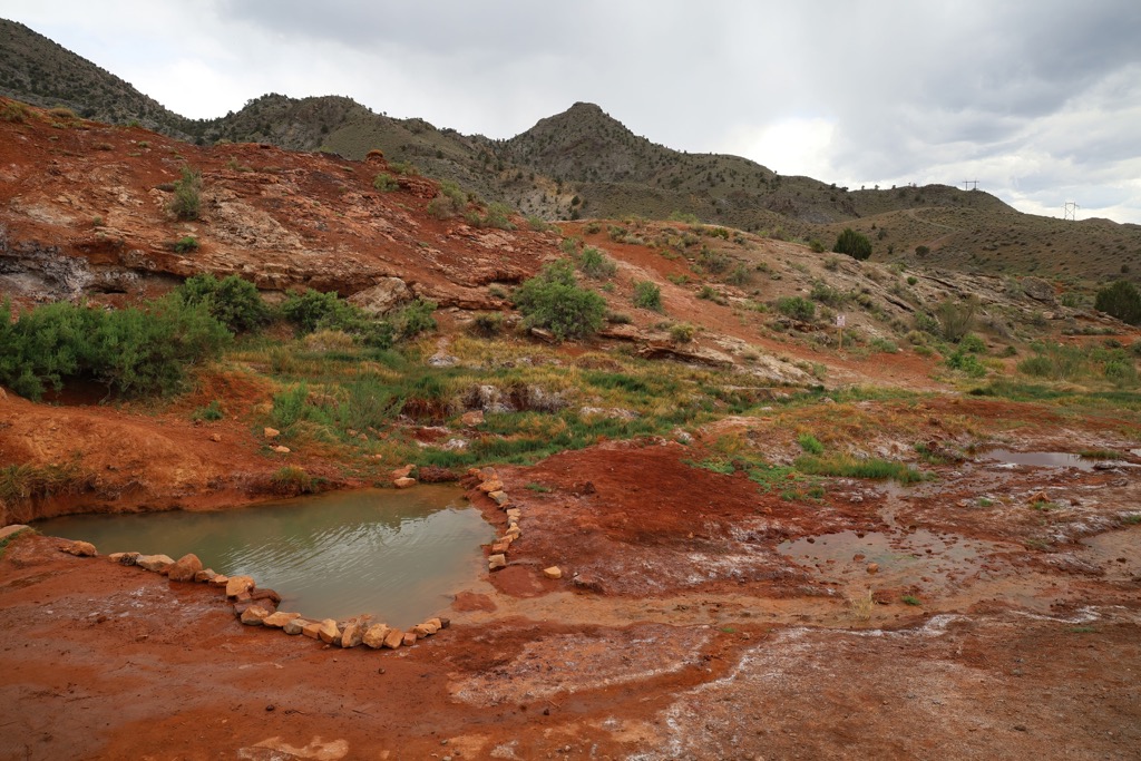
Forested hills dominate much of the region though the eastern stretches of the range contain red rock canyons which extend throughout the southern section of the state. The Pahvant Range lies entirely within Millard County and Sevier County.
The Sevier River lies along the eastern edge of the range while the Canyon Mountains are situated directly north. Sevier Lake, situated in the Sevier Desert, marks the western side of the range with the Tushar Mountains to the south.
The main spine of the range is densely forested, receiving far more rainfall than the eastern slopes of the Pahvant Range. Deep canyons and rock outcroppings are common amidst the red rock region near the city of Richfield.
The entire range lies within the Fishlake National Forest, the Pahvant Range is also located near numerous other areas for outdoor recreation. The Fremont Indian State Park lies in the southern stretches of the range. Manti-La Sal National Forest is situated northeast of the range while Dixie National Forest is to the south. Other portions of the Fishlake National Forest are situated directly north, south, and east of the range.
The Pahvant Range marks the eastern edge of the Great Basin Ranges, as the region transitions into the Colorado Plateau. The geological history of the range is intertwined with both of these geological provinces.
The Colorado Plateau, which extends to the east, features stunning rock formations primarily consisting of shales and sandstones. Much of the plateau began forming over 30 million years ago and was slowing thrust upwards to its current elevation.
Widespread erosion carved out the distinct canyons and outcroppings found in the eastern stretches of the Pahvant Range. Lack of folding of the Earth’s crust has allowed the Colorado Plateau to become an ideal spot for geologists to study the ancient layers of rocks.
Since the range is also part of the Basin and Range province, the peaks feature limestones and dolomites. Widespread tectonic extension led to the series of alternating ranges and sweeping basins, giving the region its name.
Terrain directly west of the Pahvant Range is characterized by ranges extending north to south, separated by sweeping valleys and basins.
Major peaks within the range include Mine Camp Peak, Joseph Peak, Pioneer Peak, and Mary's Nipples.
The forested patches within the range are populated by large stands of both pine and aspen trees. Lower elevations in the range feature sagebrush-grasslands, along with various low growing shrubs.
Other common tree species in the region include Douglas fir, subalpine fir, Engelmann spruce, and gambel oak. Stands of old growth forest can be found south of the range within the Tushar Mountains.
The diverse landscapes in the region allow for a variety of wildlife species to thrive. Mammals found in the area include mountain goats, bobcats, bighorn sheep, pika, pine martens, elk, foxes, black bears, mountain lions, and coyotes. Hikers may also spot eagles, turkey vultures, kestrels, and wild turkeys.

The land within and surrounding the Pahvant Range has been inhabited by humans for thousands of years, long before the arrival of European colonization. Settlements built along the shores of nearby Fish Lake date back around 9,000 years.
Prior to European colonization, the Fishlake National Forest was home to numerous Indigenous communities. Around 9,000 years ago, a number of settlements were built along the shores of Fish Lake, the remnants of which can still be seen today.
The Ute people, including the ancestors of the Ute Indian Tribe consider the range and surrounding region to be part of their ancestral homelands. The range was named after the Pahvant tribe, a branch of the Ute people and their culture. Different tribes and bands of the Ute people lived throughout present-day Utah and Colorado. There are currently three tribes of the Ute Nation.

This region also marks part of the traditional territory of the Paiute Indian Tribe of Utah. The Paiute Indian Tribe of Utah consists of five historically independent bands—Koosharem, Kanosh, Cedar, Indian Peaks, and Shivwits—all having lived in the region since time immemorial.
Settlers began arriving in the region during the mid-1800s. While some were in search of gold, many came to the region as Moron missionaries, establishing communities throughout present-day Utah.
This increased population led to trade routes being established, connecting the region to the west coast of the US. Despite their continual resistance to protect and preserve their native homelands, the Indigenous peoples of the region were continually attacked, harassed, displaced, and murdered by the settlers of Euorpean descent. Forced removal the tribes led those who survived to be placed on reservations, oftentimes far away from their native homelands.
Water rights to nearby Fish Lake were “sold” to the Fremont Irrigation Company in 1889, in the Fish Lake Water Agreement. The agreement stated that the tribal nations would be given the right to fish and use the waters of Fish Lake. Despite this agreement, the Fremont Irrigation Company did not uphold their end of the deal.
The Fishlake National Forest was officially established in 1907. The forest was expanded and combined with other forests in both 1908 and 1923.
The Pahvant Range is home to numerous hiking trails and outdoor recreation opportunities. Here are some of the top hiking areas to visit in the forest:
Mine Camp Peak marks the tallest mountain in the Pahvant Range, situated near the center of the range. The route to the summit begins relatively flat before dropping slightly in elevation and then climbing up to the top of the peak.
Hikers wind through the forested landscape before the trees begin to thin, opening up to the grassy ridgeline and summit. During the summer months hikers pass through vast sections of wild flowers. This out and back route is 3.6 miles (5.8 km) and features 629 feet (192 m) of elevation gain.
This loop trail lies along the eastern edge of the range, showcasing the red rock terrain of the Pahvant Range. The route climbs steadily throughout the sagebrush landscape, with continual views throughout.
Hikers can see red rock valleys and rock fields with the city of Richfield down below. This trail can be used for both hiking and mountain biking. The loop is 5.8 miles (9.3 km) in length and features 826 feet (252 m) of elevation gain.
This trail lies along the southern edge of the range, within the Fremont Indian State Park. The route winds through a rock canyon which features drawings made by the Indigenous people of the region.
The short loop showcases the terrain transitioning from forested hillsides into red rock canyons. Round trip the loop is 1 mile (1.6 km) in length and features 203 feet (62 m) of elevation gain.

Looking for a place to stay near the Pahvant Range? Here are some of the best cities and towns to check out in the region:
The city of Richfield, Utah lies along the eastern edge of the Pahvant Range, in the heart of Fishlake National Forest. Situated near the Sevier River, the city is home to around 8,000 residents, making it the most populous city in the south central region of the state.
Being located on the Wasatch Front, surrounded by mountain ranges, has made Richfield one of the most remote cities in Utah. The land has been inhabited for over 7,000 years, dating back to the Fremont people.
Besides hiking, visitors can also explore the region by trail running and mountain biking. Major employers in Richfield include the US Forest Service, with the Fishlake National Forest Headquarters located in the city. The small downtown area is home to a number of fantastic local restaurants and businesses.

Located an hour and fifty minute drive north of Richfield, lies the city of Provo. Home to around 115,000 residents, Provo marks the third largest city in the state of Utah. Within the city lies Brigham Young University (BYU).
The Wasatch Front lies to the east, towering over the city of Provo, while Utah Lake is located directly west. Popular attractions in the region include Provo Canyon, Sundance Mountain Resort, and Utah Lake State Park.


The highest peak in the Pavan Range is Mine Camp Peak, at 3,116 m.
The Pavan Range have 31 named peaks.


