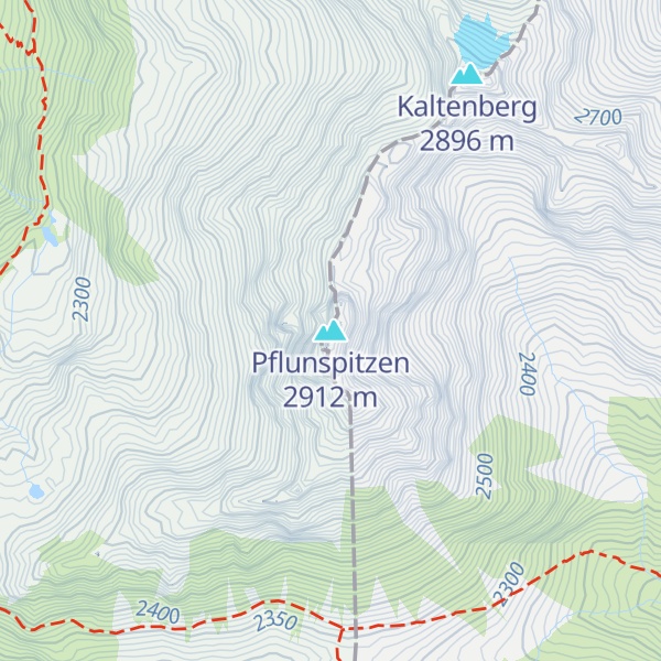
The Pflunspitzen are the highest points in the western Verwall Group in the Austrian Alps, reaching a maximum height of 2,912 m (AA). They lie west of the neighbouring Kaltenberg; the nearest village is Klösterle by Arlberg north of the peaks.
The summit block is divided into the south top (2,869 m above sea level (AA)), the fore top (Vorgipfel), the main summit (Hauptgipfel, 2,912 m above sea level (AA)) and the north top. Several routes run from the Reutlinger Hut and the Konstanzer Hut to the summit. The easiest route – climbing grade I – runs from the Reutlinger Hut via the south cold to the south top. Other routes vary in difficulty between grades III and V and are usually described as scenic rock climbing routes, as is the crossing from the north top to the Kaltenberg (III). The Via Katrin (III to VI) runs up the west face to the main summit.
We use GPS information embedded into the photo when it is available.
3D mountains overlay
Adjust mountain panorama to perfectly match your photos because recorded by camera photo position might be imprecise.
Move tool
Rotate tool
Zoom
More customization
Choose which peak labels should make into the final photo and what photo title should be.
Next
Photo Location
Satellitte
Flat map
Relief map
Latitude
Longitude
Altitude
OR
Latitude
°'''
Longitude
°'''
Apply
Register Peak
Peak Name
Latitude
Longitude
Altitude
Register
Teleport
PeakVisor
This 3D model of Sagarmatha National Park in Nepal was made using the PeakVisor app topographic data. The mobile app features higher precision models worldwide, more topographic details, and works offline. Download PeakVisor maps today.
Download OBJ model
PeakVisor
The download should start shortly. If you find it useful please consider supporting the PeakVisor app.
PeakVisor for iOS and Android
Be a superhero of outdoor navigation with state-of-the-art 3D maps and mountain identification in the palm of your hand!