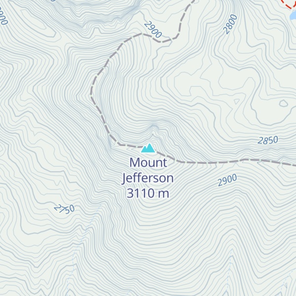
Mount Jefferson is a mountain located on the Continental Divide between Fremont County of northeastern Idaho and Beaverhead County of southwestern Montana. Mount Jefferson is the highest point of the Centennial Mountains, whose crest runs along the Continental Divide and can be climbed using a class 2 route (scramble) from the access road to neighboring Sawtell Peak.
The south and west slopes of Mount Jefferson drain into Hell Roaring Creek, thence into Red Rock Creek, the Red Rock River, the Beaverhead River, the Jefferson River, the Missouri River, the Mississippi River, and into the Gulf of Mexico.
Brower's Spring, the source of Hell Roaring Creek, on the mountain's east flank in Montana, is considered the absolute headwaters of the Missouri River.
The northeast slope of Mount Jefferson drains into the South Fork of Duck Creek, thence into Henrys Lake, the Henrys Fork of the Snake River, the Columbia River, and into the Pacific Ocean.
The mountain is named for United States Founding Father and third president, Thomas Jefferson.
By elevation Mount Jefferson is
# 4 out of 55 in Fremont County # 25 out of 180 in Beaverhead County # 15 out of 209 in Caribou-Targhee National Forest # 53 out of 324 in Beaverhead-Deerlodge National Forest # 33 out of 1850 in the Central Montana Rocky Mountains
By prominence Mount Jefferson is
# 1 out of 55 in Fremont County # 37 out of 3867 in Montana # 20 out of 3322 in Idaho # 2 out of 180 in Beaverhead County # 6 out of 209 in Caribou-Targhee National Forest # 7 out of 324 in Beaverhead-Deerlodge National Forest # 20 out of 1850 in the Central Montana Rocky Mountains
We use GPS information embedded into the photo when it is available.
3D mountains overlay
Adjust mountain panorama to perfectly match your photos because recorded by camera photo position might be imprecise.
Move tool
Rotate tool
Zoom
More customization
Choose which peak labels should make into the final photo and what photo title should be.
Next
Photo Location
Satellitte
Flat map
Relief map
Latitude
Longitude
Altitude
OR
Latitude
°'''
Longitude
°'''
Apply
Register Peak
Peak Name
Latitude
Longitude
Altitude
Register
Teleport
PeakVisor
This 3D model of Sagarmatha National Park in Nepal was made using the PeakVisor app topographic data. The mobile app features higher precision models worldwide, more topographic details, and works offline. Download PeakVisor maps today.
Download OBJ model
PeakVisor
The download should start shortly. If you find it useful please consider supporting the PeakVisor app.
PeakVisor for iOS and Android
Be a superhero of outdoor navigation with state-of-the-art 3D maps and mountain identification in the palm of your hand!