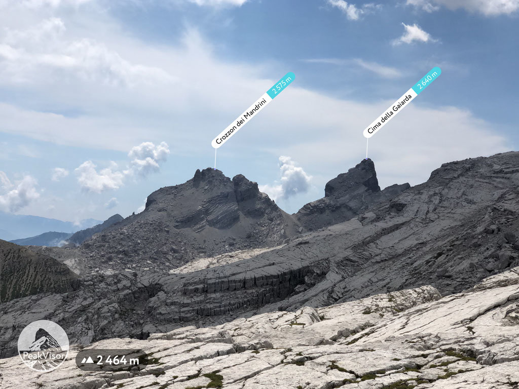
At an elevation of 2,575 m (8,448 ft.), and with a prominence of 90 m (295 ft.), Crozzon dei Mandrini forms part of the Southern Rhaetian Alps. It is situated in the province of South Tyrol, Italy.
Crozzon dei Mandrini is a somewhat tricky mountain to climb, classified as "climbing (III°).” Under the YDS classification system, which indicates the seriousness and length of the route, climbing (III°) means that one will need most of the day, including the approach to climb the mountain. There are some treacherous slopes and rock faces which call for the use of specialized mountaineering equipment. Needless to say, mountaineers should have prior mountaineering experience before attempting to scale Crozzon dei Mandrini.
There are no chairlifts to help visitors along, but there are a few mountain huts where one can seek a brief respite on the way up or down, such as Rifugio Croz Altissimo, Rifugio Stoppani, and Rifugio Selvata.
The summit is best reached by crossing the Della Gaiarda Pass, but be warned, the climb is not easy. Mountaineers should take care and be alert at all times.
Crozzon dei Mandrini is surrounded by other lesser-known peaks such as Cima Gaiarda, Monte Ridont, and Crozzon della Spora. The highest is Cima della Vallazza, at an elevation of 1,200 meters.
The earliest record of climbing Crozzon dei Mandrini dates back to 1937 and was completed by Matteo Armani, A. Giuliano, and G. Lubich.
The nearest mountain hut is Malga Spora located 1 485m/4 872ft E of the summit.
By elevation Crozzon dei Mandrini is
# 73 out of 207 in the Brenta group
By prominence Crozzon dei Mandrini is
# 66 out of 207 in the Brenta group # 92 out of 307 in Parco naturale dell'Adamello-Brenta
We use GPS information embedded into the photo when it is available.
3D mountains overlay
Adjust mountain panorama to perfectly match your photos because recorded by camera photo position might be imprecise.
Move tool
Rotate tool
Zoom
More customization
Choose which peak labels should make into the final photo and what photo title should be.
Next
Photo Location
Satellitte
Flat map
Relief map
Latitude
Longitude
Altitude
OR
Latitude
°'''
Longitude
°'''
Apply
Register Peak
Peak Name
Latitude
Longitude
Altitude
Register
Teleport
PeakVisor
This 3D model of Sagarmatha National Park in Nepal was made using the PeakVisor app topographic data. The mobile app features higher precision models worldwide, more topographic details, and works offline. Download PeakVisor maps today.
Download OBJ model
PeakVisor
The download should start shortly. If you find it useful please consider supporting the PeakVisor app.
PeakVisor for iOS and Android
Be a superhero of outdoor navigation with state-of-the-art 3D maps and mountain identification in the palm of your hand!