
Scan the QR code and open PeakVisor on your phone
The Batongguan Ancient Road is one of Taiwan’s most iconic mountain paths seeped in history. The Qing Dynasty originally built this archaic route in an attempt to penetrate Taiwan’s inaccessible mountains. Later, the Japanese settled along this route, extending the road and building homes and offices. The Qing Batongguan Ancient Road Historic Site Preservation Area (清八通關古道及舊址史蹟保存區) protects these timeworn structures. Of the 3 named mountains in this area, Gonghsan (公山) is the tallest, measuring 2,635 meters (8,645 ft).
Composed of three separate zones along the Batongguan Ancient Road, the Qing Botongguan Ancient Road Historic Site Preservation Area spans across Zhushan Township (竹山鎮) of Nantou County (南投縣) and Yuli Township (玉里鎮) of Hualien County (花蓮縣). Gongshan, Fuzi Duanya (父子斷崖), and Asanglaijiashan (阿桑來戛山) all hold evidence of age-old mountain tribes.
Lying in Yushan National Park (玉山國家公園), this high-elevation path comprises two halves: the Qing dynasty constructed the first, while the Japanese extended the second half of the trail. The Japanese resided in the low to mid-elevations, relocating Taiwan’s mountain-dwelling tribes while expanding the mountain path along the Central Mountain Range (中央山脈) corridor.

With an elevation range from 300 to 2,635 meters (984 to 8,645 ft), the climate and vegetation differ dramatically. With an annual average temperature of 52°F (11°C) at 2,500 meters (8,202 ft), temperate conifers dominate in this zone. The plant life is well-nurtured and flourishing, with 80 percent humidity and annual precipitation of 4,700 mm (185 in).
While Qing Btaongguan Ancient Road Historic Site Preservation Area occupies Taiwan’s remote center, its positioning in Yushan National Park means it lies close to other natural and historical wonders. Yushan (玉山), Taiwan’s tallest mountain, sits nearby in the west, while Fuyuan National Forest (富源國家森林遊樂區) is east. Danda Major Wildlife Habitat (丹大野生動物重要棲息環境) is situated north, while Jiaming Lake (嘉明湖), Taiwan’s second-highest alpine pond, is south.
The formation of Taiwan's Central Mountain Range (中央山脈) dates back approximately three million years to when the Eurasian and Philippine Sea plates underwent significant tectonic activity. This geological phenomenon exerted immense force, causing the land to rise vertically and resulting in the emergence of the steep peaks of the Central Mountain Range. Prior to this transformation, Taiwan existed as an underwater seabed.

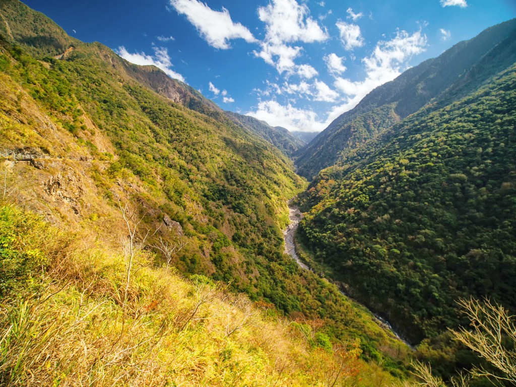
The Qing Batongguan Ancient Road Historic Site Preservation Area’s hills feature a remarkable display of exposed rock formations, including slate belts and Danan'ao schist belts. Throughout this region, various terrain exists, such as canyons, waterfalls, cliffs, bare rocks, wall collapses, folds, and source erosion.
The ecology of the region is diverse and differs according to elevation. A subtropical broadleaf forest of banyan trees thrives at 300 to 1,500 meters (984 to 4,921 ft). A temperate climate with Taiwan cypress and maple flourishes from 1,500 to 2,500 meters (4,921 to 8,202 ft). Above 2,500 meters (8,202 ft) is a cold temperate forest zone of Taiwan fir, pine, and arrow bamboo.
In terms of wildlife, you’ll spot many bird species soaring in the skies, from the Taiwan blue-bellied pheasant to the northern goshawk. Mammals, like the Taiwan black bear, Formosan macaque, and sambar, roam the woodlands.

The Batongguan Ancient Road originated during the Qing Dynasty to connect the rugged East to the urbanized West. The government built the road as a response to the Mudanshe Incident when Japan sent troops to Taiwan in 1874. The construction began in 1875 and was completed later that year. The road connected various remote locales and included bridges, ravines, wooden enclosures, and dormitory stations.
Over time, the road fell into disuse and disappeared, but the Japanese established a new route called the Batongguan Crossing Mountains Road in 1919. Over time, extensions were added during the Japanese Occupation Era to monitor and control Taiwan’s indigenous tribes who sought refuge in the mountainous region. The modern-day Batongguan Ancient Road is a restored version of the original road.

Nowadays, the preserve is a bastion of natural beauty. Many routes exist to take hikers deep into the mountains. In addition to all the usual precautions, preparing for intense rainfall is essential. Here are some of the best hiking trails and areas within the Qing Batongguan Ancient Road Historic Site Preservation Area:
Spanning from northeast to southwest through Yushan National Park, the Batongguan Ancient Road offers a unique glimpse into Taiwan's history from the Qing dynasty to the Japanese Occupation Era, and visitors can still stumble upon hidden artifacts like bottles, tools, or coins scattered across the grassy plains.
At specific points along the road, like near Gongshan, are old residences of the Bunun people. Slatted stone walls, wooden houses, and thatched roofs still display in the deep mountainous woodlands. In the southern region of Gongshan is the old Tarunas Station, completed by the Japanese in 1923 and in operation until 1940. Situated at 1,800 meters (5,905 ft), this office facilitated the administration of the local Taiwan tribal population. A community of dilapidated homes spans between 1,400 to 1,800 meters (4,593 to 5,905 ft).

While this hike does not involve any summits, the captivating scenery along the trek is enchanting. Hikers will ramble through shaded and vibrant woodlands, immersing themselves in a sea of lush greenery. Emerging into open spaces, they’ll encounter meadowed mountain slopes that glisten in golden hues under the warm sunlight. The surrounding peaks, adorned with dense forests, create a picturesque tapestry of jade-colored jungles, adding texture and depth to the landscape.
Near the southeast end of the Batongguan Ancient Road lies a splendid 11.6 km (7.2 mi) hike leading through a lush, moss-covered forest and across towering summits. The upper sections afford generous views of Taiwan’s stunning and untouched eastern countryside.
Starting from Yuli Shan (玉里山), tread south to Zhuoxi Shan (卓溪山), admiring the views of the striking Huadong Valley (花東縱谷) to the east with its deep valleys and sharp rises. Observe the expansive Pacific Ocean extending past the rolling Hai’an Range’s (海岸山脈) coastal hills. From Zhuoxi Shan, a two-story watchtower is perched atop the summit, from where you can locate Taiwan’s behemoth peaks of Yushan, Xinkang Shan (新康山), Maxi Shan (馬西山), and even Danda Shan (丹大山) further north.

On the way to Asanglaijiashan, you’ll encounter an incredibly dense rhododendron forest. Layers of velvety green moss adorn the trees and boulders, creating an emerald world of greenery on the way to Asanglaijiashan. Once in the clearings, you can overlook the coastal hilly scenery and the vibrant forests that flourish in the valley.
Yushan’s bucket list climb presents hikers with an exciting opportunity to conquer multiple peaks in one trail. For most hikers aiming to summit Taiwan's tallest mountain, the primary goal is to ascend Yushan Main Peak. However, those seeking an extra challenge and adventure may consider continuing their journey to the other peaks of Yushan.
The hike begins at Tataka Trailhead, where you’ll embark on an 8.5 km (5.2 mi) gravel path leading to Paiyun Lodge. From there, ascend Yushan Front Peak (玉山前峰), which is only a short 400-meter (1,312 ft) walk away. A narrow and rocky 2.2 km (1.3 mi) road adorned with dense Yushan juniper woodlands leads to the summit of Yushan West Peak (玉山西峰).

Paiyun Lodge is hikers' favored overnight rest stop before their early morning ascent to Yushan Main Peak. Although it is technically feasible to complete the climb in a single day, it’s not recommended due to the difficulty. The journey to Yushan Main Peak from Paiyun Lodge is physically demanding, as you’ll navigate a steep and uneven rocky path that eventually narrows to a threateningly thin ridge.
However, the challenges become insignificant upon reaching the breathtaking summit of Yushan Main Peak, with its panoramic views of the surrounding Yushan peaks. Stand at an impressive altitude of 3,952 meters (12,966 ft) and bask in the glory of conquering Taiwan's highest peak.
If you wish to explore additional peaks, Yushan East Peak (玉山東峰) is the closest to Yushan Main Peak, located just 1.2 km (0.7 mi) away. Despite its relatively short distance, the steep terrain of Yushan East Peak poses a significant challenge, even for experienced hikers. Meanwhile, Yushan North Peak (玉山北峰) is situated 2.4 km (1.5 mi) from Yushan Main Peak. To reach it, first descend Yushan Main Peak and follow the connecting trail, scrambling to the summit.
To access Yushan South Peak (玉山南峰), take a short detour along a spur trail. After trekking for 2.5 km (1.5 mi), you’ll reach the least difficult summit of the Yushan peaks.
As a long and arduous trek, the Southern Section Two Trail is recommended for experienced hikers seeking a challenging adventure. This trail predominantly exists above 3,000 meters (9,840 ft) and features continuous climbs and descents of 1,000 meters (3,200 ft) along switchbacked paths.
One advantage of this trail is its lack of crowds, mainly due to the demanding terrain, which includes steep ascents, dramatic cliffs, and high altitude. As you ascend through the clouds, you’re rewarded with awe-inspiring views of Taiwan’s rugged backcountry.
A stunning feature of the trail is Jiaming Lake (嘉明湖), which serves as an alluring highlight and is located a mere 11.6 km (7.2 mi) from the Xiangyang Trailhead. Taiwan’s second-highest alpine lake sits at an elevation of 3,310 meters (10,859 ft) and is renowned for its crystal-clear and reflective waters, resembling a magnificent pearl nestled in the mountains.
Nestled in the mountainous region of Yushan National Park, Dongpu Hot Springs (東埔溫泉) offers visitors the opportunity to enjoy the therapeutic properties of mineral-rich waters.

The hot springs at Dongpu are believed to have various health benefits due to the minerals present in the water. These minerals promote relaxation, improve blood circulation, and relieve muscle aches and joint pain. The warm and soothing waters create a tranquil atmosphere, perfect for unwinding and rejuvenating.
Dongpu Hot Springs also serves as a gateway to the local culture and cuisine of the region. You can indulge in delicious local dishes, often featuring fresh mountain produce and regional specialties.
As the Qing Batongguan Ancient Road Historic Site Preservation Area lies in Taiwan’s remote country, the two closest places to stay are Alishan Township (阿里山鄉) nearby and further afield Chiayi City (嘉義市).
Alishan Township, known for the magical Alishan National Forest, is a captivating destination celebrated for its stunning natural beauty and rich cultural heritage. Nestled amidst mist-shrouded peaks, Alishan offers visitors a refreshing escape from bustling city life.
Most people visit Alishan Township for Alishan National Forest (阿里山國家森林遊樂區). The forest is a pristine natural wonder and is one of Taiwan’s top attractions. Spanning over 1400 ha (3,459 ac), this rainforest boasts lush greenery, towering trees, and a diverse ecosystem. It is a haven for nature enthusiasts and hikers who can explore its numerous trails, cascading waterfalls, and serene lakes, immersing themselves in the tranquility of the jungle.

The Alishan Forest Railway is another popular attraction. Initially built to transport timber in this past logging area, Alishan Forest Railway is now purely used for tourists to marvel at the flourishing forest and seasonal blossoms. This railway line connects the woodlands to Zhushan Sunrise Platform and Alishan’s Giant Tree Trail.
Furthermore, Alishan is renowned as a prominent tea producer in Taiwan, celebrated for its high mountain tea. The ideal location to appreciate Alishan's picturesque tea plantations are the Shizhou Trails, situated east of Alishan. Immerse in the beauty of neatly arranged rows of tea plants and relish the herbal fragrance that fills the air. The trails offer an opportunity to embark on scenic hikes, survey the seasonal flowers, bask in the refreshing mist blanketing the rolling mountains, and gaze at the vivid sunset.
Chiayi City, located in southwestern Taiwan, is a vibrant urban center known for its rich history, cultural heritage, and delectable cuisine. The city seamlessly blends traditional Taiwanese charm with modern developments, offering visitors an authentic experience.
For magnificent views of Chiayi City, make your way to the Sun Shooting Tower (嘉義市忠烈祠) located within Chiayi Park. This impressive bronzed cylindrical structure stands at a height of 40 meters (131 ft). Resembling Alishan's Sacred Tree with its hollow strip in the middle, the tower's viewing deck provides a stunning vantage point to gaze upon Chiayi City and the picturesque plains and southern hills.
Hinoki Village (檜意森活村) is a fascinating historical area that holds great cultural significance. Originally inhabited by Japanese loggers, this quaint community showcases the charm of traditional Japanese wooden architecture. The well-preserved houses have been repurposed into delightful coffee shops and boutique stores.
Finally, you can’t visit Taiwan without visiting a night market. Throughout different cities, night markets offer a range of the region’s specialty cuisine. In Chiayi, the Wenhua Road Night Market’s (文化路夜市) bright lights attract locals and tourists to a jam-packed alley of food vendors. Some of the most electrifying Chiayi dishes include turkey rice, beef offal soup, and fish head casserole. For dessert, try the soya milk tofu pudding or the starfruit juice.
Take the Taiwan High-Speed Rail (HSR) or local express train (TRA) from Taiwan’s major cities to Chiayi City. Once in Chiayi, take the 7322 bus bound for Alishan and then transfer to the 6739 bus heading to Sun Moon Lake. When you reach the Tataka Visitor Centre stop, exit the bus. This is near where the Qing Batongguan Ancient Road Historic Site Preservation Area beings.
Alternatively, you can rent a car or scooter from Chiayi City to reach the Qing Batongguan Ancient Road Historic Site Preservation Area, which is approximately 86 km (53 mi) away.


