
Scan the QR code and open PeakVisor on your phone
Nang Xaldangaas Heritage Site and Conservancy is located at the north end of Graham Island in the Haida Gwaii archipelago of British Columbia, Canada. The beautiful wilderness area has been inhabited for thousands of years by the local Haida people. Encompassing parts of the western shores of Masset Inlet, the conservancy is an important wilderness and cultural area.
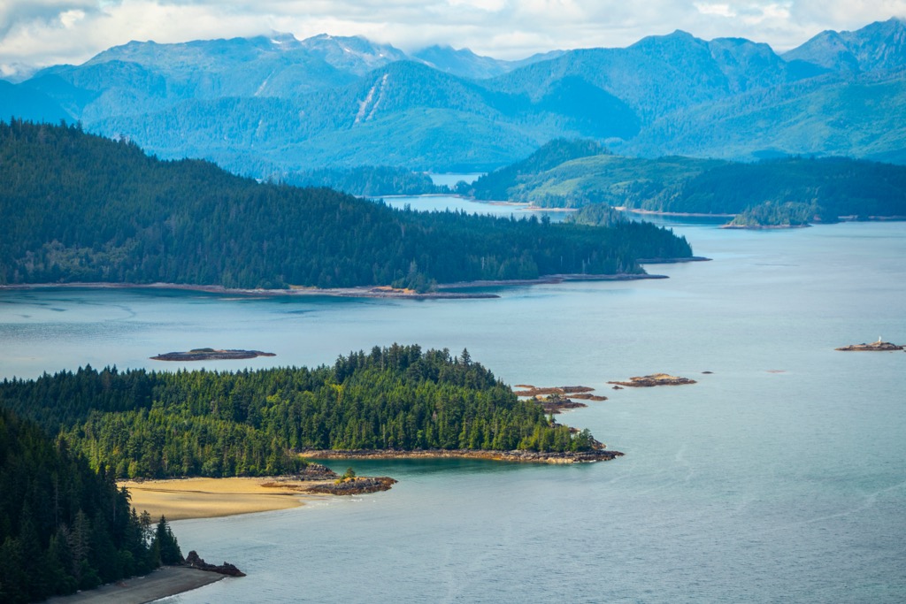
Nang Xaldangaas Heritage Site and Conservancy encompasses beautiful wilderness areas and important cultural areas on Graham Island. Graham Island is the largest island in the Haida Gwaii archipelago which is off the northwest coast of British Columbia, Canada.
The park was created in 2008 as part of a program where the local indigenous stakeholders co-manage culturally and ecologically important areas with Parks Canada. There are important wetlands in the park that make it important to conserve the wilderness as well as many cultural sites the Haida value as part of their history and cultural identity.
The community of Masset is across the Masset Inlet from the park, and a boat from the community is the easiest way to access the park. Within the park are several Haida villages and seasonal camps located at Sa-ouchten, Yan, Astowa, Kunglelung, Tohlka, Mi-ah, Kung-oas, and Skaos. In Skaos (George Point) is a Haida Watchmen camp, who are workers designated to protect Haida heritage sites and act as interpreters for visitors.
The heritage site and conservancy encompass 16,695 ha (41,254 acres) of terrestrial and marine habitat. Nearly 7,000 ha (17,000 acres) of the park are upland areas that reach from the shore to about 91 m (300 ft) with several points that stand out among the coast such as Griffith Point and Deepwater Point.
The foreshore and marine component of the park covers nearly 10,000 ha (24,700 acres) of important intertidal areas and kelp forests which help preserve the integrity of internationally significant wetlands. Nang Xaldangaas Heritage Site and Conservancy is part of an archipelago-wide system of protected areas. The following are some of the additional nearby and major conservation areas.
The Haida Gwaii archipelago is a place of natural beauty, rich cultural history, and diverse geological events. The northernmost and largest island of the archipelago is Graham Island, upon which Nang Xaldangaas Heritage Site and Conservancy is located at the north end.
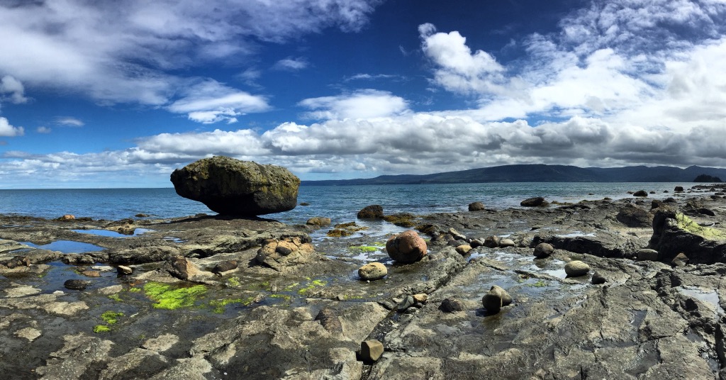
The geological history of Graham Island spans hundreds of millions of years, where today we can see the results of the geological process as volcanic landscapes and captivating coastal formations. Graham Island was created from three major series of volcanic eruptions which occurred along the Queen Charlotte Fault.
The Queen Charlotte Fault was a site of active subduction and later rifting which created the opportunity for the volcanic events that lead to making the archipelago. This fault marks the boundary between the North American and the Pacific tectonic plates.
The first event occurred several hundred million years ago when the seafloor in the Pacific was rifting, and flood basalts erupted onto the ocean floor. Subsequently, starting about 200 million years ago, volcanoes erupted for about 5 million years to create a major terrane, which is called Wrangellia.
The Wrangel terrane reaches from Vancouver Island to central Alaska and comprises the base for most of the islands along the Pacific coast. However, even after the accretion of Wrangellia to the coast during the Jurassic and Cretaceous, volcanic activity continued along the Queen Charlotte Fault.
While some of the magma simply intruded the islands to form batholiths, during the Paleocene Graham was covered again with basalt lava. Known as the Old Masset Formation, Graham Island is topped with the basaltic lava flows that originated from ancient volcanic events over successive eruptions.
Due to continued tectonic activity, the terrain was lifted to form the striking topography that we see today. The Queen Charlotte Fault is still an active strike-slip boundary that is the source of disruptive geological events, such as earthquakes. Furthermore, the activity along the fault continues to uplift and change the Queen Charlotte Mountains and the archipelago in general.
During the Pleistocene, Haida Gwaii experienced intense glacial activity that affected the topography and ecology of the islands. Ice sheets advanced from the coast and from the peaks of the Queen Charlotte Mountains carving deep fjords, shaping mountains, and depositing glacial sediment.
Changes in sea level and the elevation of the islands were also prominent during and after the Pleistocene. As glaciers advanced, sea level dropped to expose large areas of land between Haida Gwaii and the mainland. This created opportunities for plants, animals, and humans to migrate through the new territory.
As the glaciers melted and sea-levels rose, the glacier carved valleys filled with water to become rugged coastal fjords. The migration routes were cut off as the oceans rose, forcing indigenous people to climb higher and higher to avoid the rising ocean. The islands of Haida Gwaii were once the peaks of a mountain range that was flooded as the glaciers melted.
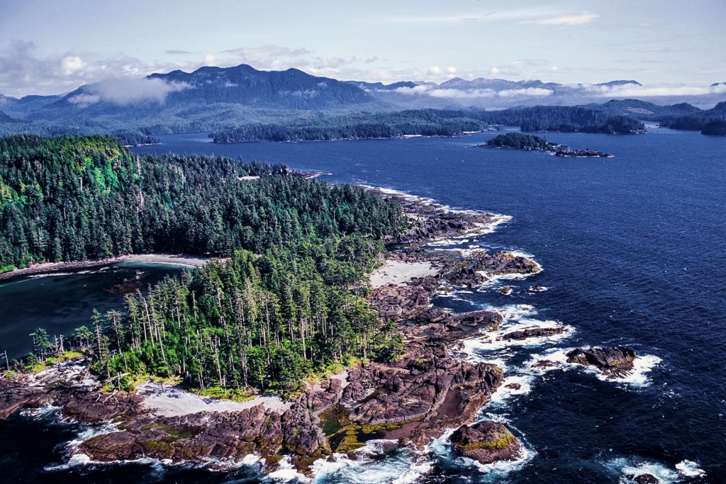
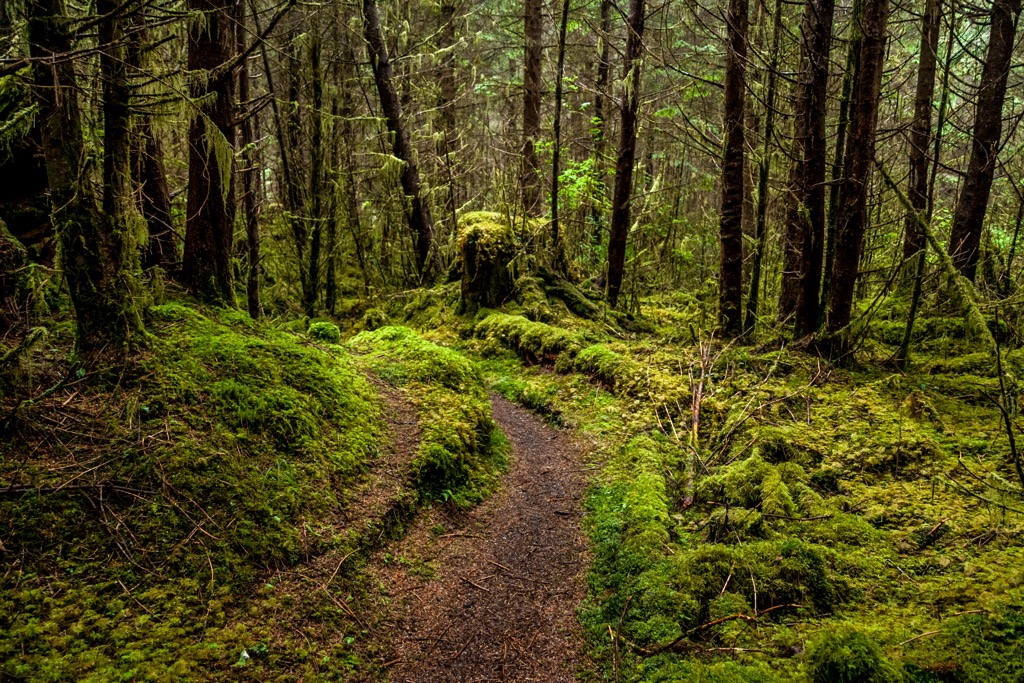
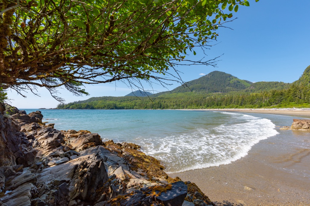
Surrounded by ancient rainforests, stunning vistas, and the marine environment of the Masset Inlet, Nang Xaldangaas Heritage Site and Conservancy is a breathtaking location to explore. The towering Sitka spruce, western red cedar, western hemlock, and Douglas fir forests are ancient and awesome.
Many of the forests within the park have remained relatively untouched so that the lush canopy still provides a home for a variety of plant and animal species. The vibrant undergrowth of ferns and salal help create a peaceful and serene experience while hiking through the woods.
The marine environment of the park includes the foreshore and parts of the inlet and adjacent bay. The wetlands of Sturgess Bay and Maast Island provide important habitat for thousands of migratory and local birds such as the long-tailed duck, western grebe, red breasted merganser, great blue heron, and the red-breasted merganser.
Furthermore, the marine areas of the park include a variety of unique habitats that are home to kelp forests, the rare small spike-rush, and eelgrass beds that form “hanging lagoons”.
The park is home to some animals such as northern goshawks, marbled murrelets, common murres, raccoons, and black-tailed deer. However, introduced animals such as the raccoons and deer pose a threat to local species and ecosystems.
For over 13,000 years the Haida people have inhabited Haida Gwaii. It is one of the rare circumstances that the current indigenous population are likely descended from literally the first inhabitants of the region. Archaeological evidence supports the claim that the Haida have inhabited their territory since the end of the Pleistocene.
The islands of Haida Gwaii are the source of abundant resources, including salmon, halibut, shellfish, and cedar trees which sustained their communities for thousands of years. The Haida developed a strong seafaring tradition that allowed them to easily travel through their archipelago for hunting and gathering of resources.
They also developed sophisticated fishing techniques, such as the construction of fish traps and weirs, to ensure a stable, year-round, supply of food. With a steady source of food and an abundance of resources for their shelters, the Haida had the time and energy to create a vibrant culture and a social structure.
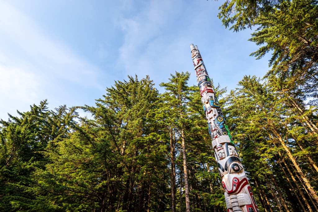
Long houses made from cedar planks were a traditional home for the Haida and they decorated the doorways with intricate carvings. Furthermore, their craftsmanship extended to constructing canoes, totem poles, masks, and jewelry. Upon their handicrafts, the Haida people preserved their history, legends, and genealogy.
The Haida way of life remained relatively unchanged for thousands of years, until Europeans arrived on their islands in the eighteenth century. The Europeans came to harvest furs, principally from the sea otters that lived in the region. However, with the Europeans came a disruption to the traditional hunting and trading practices, changing the lifestyle of the Haida forever.
Furthermore, the traders brought diseases which devastated the Haida population. While the Haida have shown significant resilience to the pressures of assimilation and marginalization, there is still a strong Haida presence on Haida Gwaii.
There are continued efforts to reassert their sovereignty over their traditional territory and there are efforts to preserve the heritage. Within Nang Xaldangaas Heritage Site and Conservancy there are many Haida villages and seasonal camps. The Haida have a program in place, called The Watchmen, that helps to preserve their culture.
There are Watchmen camps across Haida Gwaii, and one within Nang Xaldangaas Heritage Site and Conservancy. The Watchmen are employees of the Haida Nation who are mandated to help protect and preserve heritage sites. The Watchmen also provide the invaluable service of acting as interpretive guides when visitors arrive at heritage sites.
Within Nang Xaldangaas Heritage Site and Conservancy there are over thirty archeological sites with a variety of cultural values. Among the cultural and heritage sites of the conservancy are over 180 culturally modified trees, lithics, pre-contact burial material, fire broken rock, charcoal, shell midden, human affected remains of animals such as deer, bird, seal, and otter, habitation depressions, plank houses, human remains, and human made bark strips.
Nang Xaldangaas Heritage Site and Conservancy was an important place for the Haida people for thousands of years, and it remains important today. It is likely that there are more culturally important sites within the conservancy that have not been discovered or reported.
The Haida today work together with Parks Canada to manage and preserve the lands and the heritage sites.
Nang Xaldangaas Heritage Site and Conservancy is a remote conservancy on the north end of Graham Island. There are no roads that lead directly to the park, and the easiest way to access the conservancy is by taking a boat from the community of Masset.
Paddling along the coast is likely one of the best ways to experience Nang Xaldangaas Heritage Site and Conservancy. There are many locations along the coast where visitors can pull onto the beach for the day for a hike or to set up camp for the night.
Visitors will be greeted each day with spectacular scenery and an exceptional wilderness experience. Within the narrow park there are countless opportunities for exploring and discovering ancient Haida sites. If you encounter a Haida heritage site, treat it with respect and do nothing that will alter or damage the site. The Haida welcome respectful visitors to come and explore their beautiful land.
Haida Gwaii is a stunningly beautiful wilderness and cultural destination. Nang Xaldangaas Heritage Site and Conservancy is one of the many places on the island to visit. The following are the major communities around the conservancy and in the archipelago.
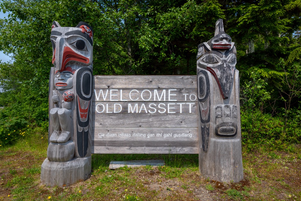
Masset is the closest community to Nang Xaldangaas Heritage Site and Conservancy, as it is located just across the Masset Inlet from the conservancy. The Haida people have inhabited this part of the islands for generations and may be where Europeans first encountered the Haida.
There are many activities in Masset to enjoy such as fishing, hiking, golfing, cycling, and paddling. The village is the northern terminus of Canada’s Yellowhead Highway, and it also has a regional airport to bring in visitors.
From the village of Masset, visitors can take a boat across the inlet to visit Nang Xaldangaas Heritage Site and Conservancy or drive a little to the east to access Naikoon Provincial Park where the Tow Hill Ecological Reserve is also located along with opportunities for camping, hiking, and backpacking.
Formerly known as the community of Queen Charlotte, Dajiing Giids is one of the larger settlements in Haida Gwaii. The community is located along the southern shores of Graham Island, about 70 km (48 mi) south of Nang Xaldangaas Heritage Site and Conservancy.
Daajing Giids is often the starting point for charters and excursions to Gwaii Haanas National Park Reserve and Heritage Site. From here visitors can tour the grand cedar forests of Haida Gwaii, admire new and ancient totem poles, visit shipwrecks, or paddle along the beautiful coast.
In addition to Gwaii Haanas, Naikoon Provincial Park is relatively nearby as is Yaaguun Suu. Visitors can backpack along the eastern shore of Graham Island in Naikoon Provincial Park and visit a shipwreck along the way. In Yaaguun Suu visitors can follow historical Haida trails and enjoy the serenity around Yakoun Lake.


