
Scan the QR code and open PeakVisor on your phone
Serbia is home to 6,388 named mountains. The highest is Midžor at 2,169 m.
You can expect lush old forests, beautiful meadows, and fields full of crops, together with hills full of water here. Serbia truly is a gem of the Balkan Penisula, lying in its center. If you want to experience this amazing land, make sure to visit one of its metropolis cities and squeeze in a few hikes. There are 6388 named mountains in Serbia. The highest and the most prominent mountain is Midžor (2,169 m/7,116 ft).
Serbia is a country that occupies a part of the Pannonian Plain and Central to Western Balkans. It is landlocked in the southeast of Europe. Due to its position, it borders numerous countries. To the north of Serbia lies Hungary. To the east are Romania and Bulgaria, North Macedonia and Kosovo border it in the south.
The countries it almost shares its language: Croatia, Bosnia and Herzegovina, and Montenegro border Serbia to the west. The whole country covers an area of about 88,300 sq. km (34,116 sq mi), and around 7 million people live here.
With a lot of rivers, roads, and telecommunication networks connecting the country, it offers a gateway between the continents of Europe and Asia. Serbia is a strategically important country due to this. In other words: it's the place where different spheres of activity interact with each other. In addition, it also has quite lovely natural landscapes.
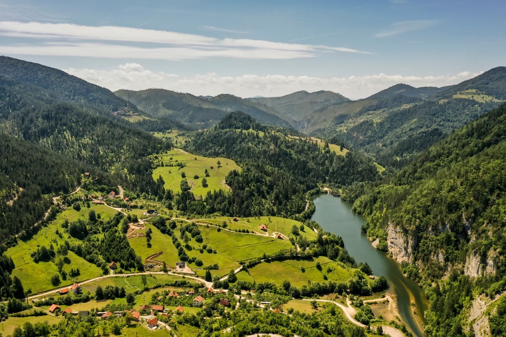
Serbia has various landscapes to offer, ranging from the fertile plains in northern Vojvodina to limestone ranges in the east and ancient mountains and hills to the southeast. The Pannonian Plain covers the northern third of Serbia, while a smaller, northeasternmost part of Serbia extends into the Wallachian Plain.

The terrain in Central Serbia is dominated by the region of Šumadija, whose name translates as Forestland. The Northern countryside features fertile flatlands, but the Eastern part has a lot of limestone ranges and basins. The three mountain ranges, Rodope, Carpathian, and Dinaric, meet in the Southern parts of Serbia.
Mountains dominate the southern third of Serbia. The western and southwest parts of this mountain are comprised of the Dinaric Alps, while the Eastern regions are a mix of Carpathian and Balkan mountain ranges. The highest peak is called Midžor (2,169 m/7,116 ft) and reaches up to 2,169 m (7,116 ft), while the lowest point is just 17 m (55 ft), near the Danube River.
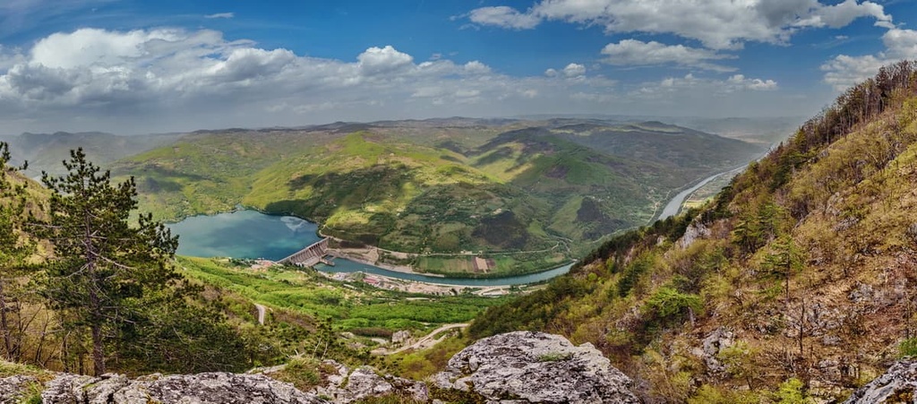
In Serbia, three major rivers or the Danube, Sava, and Tisa, dominate the landscape, and all three are navigable. The longest river is the Danube, which flows for 588 km through Serbia and visits the capital Belgrade as well.
The Danubian river system is the longest in Serbia, later flowing into the Black Sea. The Tisa and Sava Rivers are the most important tributaries of the Danube in Vojvodina. When it rains in Fruška Gora, the water flows into the Sava River, while the Tisa flows from Hungary.

Belgrade has a hilly terrain and an average elevation of 116.75m (383 ft) above sea level. Belgrade became Serbia's capital due to its strategic location. It sits at a pivotal point where the Sava and Danube Rivers converge.
The Kalemegdan fort, an ancient castle, dominates the skyline. The city was once part of the Roman empire and still has reminders of its prominence to this day.
Serbia is known for its natural beauty. For example, 182 trees in Belgrade have been declared natural landmarks, meaning that their future is secured and they are protected by law. There are also over 4,000 acres (40 ha) of green space in the capital city of Belgrade and many parks to enjoy a walk through the city.

Serbia has a lot of variety when it comes to geology. In the north, we have the fertile Pannonian Plain. The southeastern mountainous area belongs to the Rilo-Rhodope system. The Dinaric Alps stretch in the west and southwest. The central part consists of hills and valleys crossed by rivers.
Serbia is part of the Eurasian Plate, but it is part of diverse geologic history. It is exciting because it is divided into five regions, composed of the Balkan, Carpathian, and Dinaric systems. First and northernmost lies the Pannonian Plain, which occupies the northern part of Serbia. The Dinaric Alps stretch in a general northwest to northeast.
Carpathian-Balkan Arc covers Eastern Serbia. Serbian-North Macedonia massif is in the south, following along the Great and South Morava Valleys into North Macedonia. Its Vardar Zone is a belt east of the Dinaric Alps and is divided into three parts: Srem, Jadar, and Kopaonik.

The landforms of Serbia tend to fall into regional groupings because the country is landlocked. The most significant division within Serbia is between Vojvodina and everything south of it.
The plains of north Vojvodina generally lie within an elevation range between 60 to 100 m (200 to 350 ft). Fruška Gora hills break up and break these plains up, running between the Danube and Sava rivers. While this is relatively low land, these mild hills come up to 600 m (1,968 ft) in elevation.
Central Serbia has a hilly and even mountainous nature. You will be able to enjoy sections of the Dinaric Alps in the West and the Carpathian and Rhodope rangest to the west.

The Kopaonik mountain massif reaches a height of 2,000 m (6,600 ft). This area is earthquake-prone and should be taken into consideration when visiting. Summits of the Šumadija region range between 600 to 1,810 m (2,000 to 3,500 ft). The highest peaks in Serbia include:

Serbia's vegetation is a bridge between Central European and Mediterranean types. There are lots of differences between climates in Serbia. They're caused by differences in elevation, proximity to the sea, and exposure to wind. Belgrade generally has a continental climate with cold and dry winters and warm and humid summers.
This area was a grassland steppe until the eighteenth century when Austrian colonization of dry Vojvodina began. However, it is evident that forests dominated the region. Only about 5% of the area is covered with trees now, mainly in Fruška Gora.
But the rest of Serbia is different. It is full of broad-leaved forests, mostly oak and beech. Serbia has 29.1% of its territory covered by forest. There is currently 2,252,000 ha (225,200,000 ar) of forest or 0.3 ha (30 ar) per inhabitant on its territory. The most important types of trees in Serbia are oak, beech, and pine.

There are 4,082 different species of animals in this country. There is a larger number of mammals, with 12 listed as endangered. Of course, there are 238 birds, 35 reptiles, 10 amphibians, and 125 fish species also included in this number.
Numerous species in Serbia are endangered and threatened, the majority of which are plant and bird specimens. Serbia has protected around 6% of its land until now because it has always been rich in natural beauty.
There is a total of 463 protected natural areas in Serbia. Of this, 5 are national parks, 16 nature parks, 67 nature reserves, 16 landscapes, 42 protected areas of significance, and last but not least, the most common protection clause - 317 natural monuments.
Serbia also has a rich diversity of wild animals. Deer and bears are some of the larger mammals in forest regions near cities, while wild pigs are found in mountainous beech forests. The country’s terrain provides a suitable living environment for many different animals, including wolves, lynx, bears, foxes, and stags. There are 17 snake species native to the country.

Pollution is a massive issue in Serbia, and waste management is one of the most important pollutants. Recycling only accounts for 15% of the waste, thus sparking more need for better public awareness and recycling methods.
Most of the population in Serbia are Slavic people. They moved into the area during the fifth to the seventh century, encountering Illyrian people. The Illyrians and Celts were indigenous here and lived in harmony with the Greeks until the Romans invaded the area. Serbia was part of the Roman province Moesia and Dacia, and they built numerous Roman towns and military outposts here.
The Serbian Empire was a regional power in the Balkans from the fourteenth century. After being defeated in the Battle of Kosovo in 1389, it was forced to submit to Ottoman rule. Throughout the fifteenth to nineteenth centuries, Serbia fought bravely against Ottoman rule. Only in 1877 did it manage to gain independence.

The Balkan Wars followed, intending to gain control over land that was once in possession of the Ottoman Empire. After these wars ended came World War I. It started when a Serbian nationalist assassinated Archduke Ferdinand in Sarajevo, Bosnia and Herzegovina, which made Austria look for revenge.
After this, the formation of Yugoslavia started, and Serbia has been an integral part of it since the 1920s. This included the territories of Serbia, Bosnia and Herzegovina, Kosovo, Croatia, Montenegro, Slovenia, and North Macedonia into its plan.
First, the locals formed an independent federation known as the Kingdom of Serbs, Croats, and Slovenes. King Peter I of Serbia became the first monarch, and his son, Alexander I, then became Emperor Alexander I in 1832.
The country of Yugoslavia properly officiated since 1929 and was formally made official in 1945, after World War II. The capital city of Belgrade was the main hub for this union, though, after WWII, communism started to take control, and Josip Broz Tito kept this union grounded and stable.

After Tito died in the 1980s, communism came to an end in eastern Europe, and Yugoslav society stood alone. Serbian leader Slobodan Milošević had the idea of creating a "Great Serbia," which would have included some of the former countries of Yugoslavia.
Though it sounded like a good idea, it only left the other countries in turmoil. Soon, Slovenia, Croatia, Bosnia and Herzegovina, and North Macedonia left the union. Kosovo and Montenegro remained as part of a bigger country or Serbia and Montenegro.
The state has also been subject to international sanctions because of this. Kosovo had bloodshed since the 1990s when an Albanian-Muslim-dominated province declared independence. Of course, one cannot forget the bloodshed in Croatia, Bosnia and Herzegovina, and Slovenia as well.
In 2006, the people of Montenegro decided to vote for independence. That led to the official split of Serbia and Montenegro, leaving Serbia with only one name. From then on, Serbia was an independent nation within its own country but under the name Republic of Serbia.

The Southern Serbian province of Kosovo and Metohija has been under international protection since the conflicts between Serbs and Albanians in 1999. Kosovo declared its independence in 2008 and is an independent state. Still, Serbia boycotted the move and said it was illegal. Nonetheless, numerous countries like the EU and US recognized them.
Unlike other Slavic nations, Serbs do not have a language of their own. They speak essentially the same language as the members of three of their neighbors: Croats, Bosniaks, and Montenegrins. Some pronunciation and vocabulary are distinctive from these languages, but overall, they speak almost the same language.
Serbia uses its own slightly modified Cyrillic alphabet to write Serbian. This script was created by the Orthodox missionary brothers Saints Cyril and Methodius, who first translated the Bible into Slavic.

When visiting Serbia, make sure to include these mountains and hikes into your itinerary:
Tara National Park has several peaks with deep gorges between them, one being the Drina Gorge, with cliffs reaching 1,000 m (3,280 ft). It is famous for the rare endemic Tertiary Spruce, the Serbian spruce (Picea omorika), which is now protected by law.
Most people want to hike the highest peak or Koziji Rid (1,591 m/5,219 ft) when visiting. Despite the fact that this trail is short and gains just 150 m (492 ft) in elevation, it can still be fun! It’s a tremendous day-long adventure if you have the time.
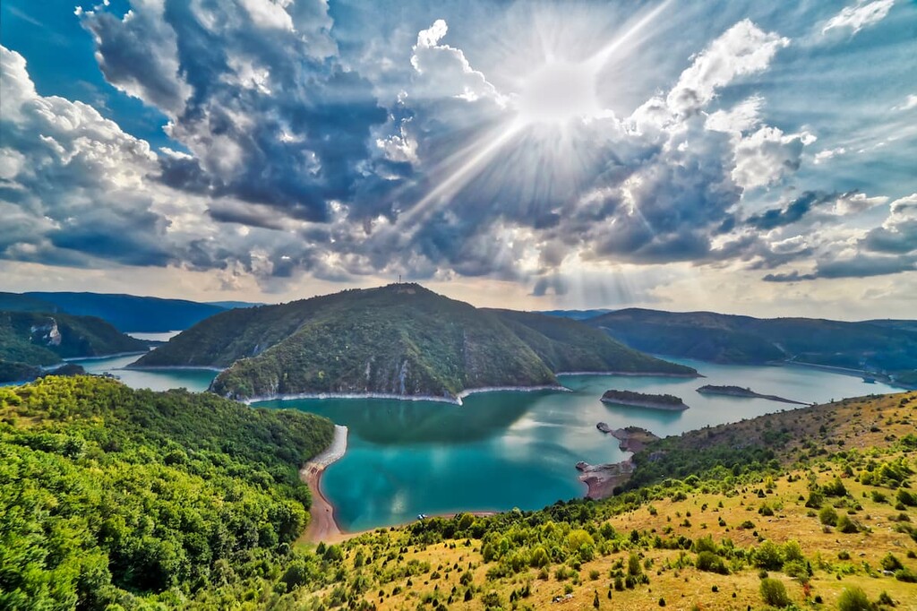
The Uvac Gorge is home to a protected griffon vulture population, and they can be seen along the gorge with a length of 15 km (9 mi). Once you reach Molitva (Prayer) Peak, you'll have many great vantage points for seeing the magnificent valley below. The Uvac Ice Cave is one of the more popular tourist destinations here, and you'll be able to get a great viewpoint for photographs.

Serbia's highest mountain is Stara Planina. The hike to most peaks consists of forests, meadows, and creeks. One can also find the magnificent landscape here in Bulgaria since the Stara Planina is part of the Balkan mountain range.
The most famous peak here is Midžor (2,169 m/7,116 ft), the highest peak in Serbia. This route follows the Toplodolska river and will pass many waterfalls, including Piljski, Čunguljski, and Kurtulski. It's a 23 km (14 mi) route with an easy-to-follow path.

The major cities in Serbia include:
Belgrade is a city in Serbia with a population of 1.4 million people. It is the capital and the largest city in Serbia. Belgrade is a major European cultural center with more than 3,000 years of continuous urban history and has been an important cultural crossroads.

Belgrade is known for its cultural heritage, rich history, lively nightlife, and more than 40 museums. It was also the capital of Yugoslavia from 1918 until its downfall. Belgrade is home to many cultural institutions, including the National Library of Serbia and the Serbian National Theatre building on Kalemegdan fortress.
Novi Sad is the second largest city in Serbia. It has a population of around 250,000 people and is the country's main economic, cultural and educational center. Novi Sad was founded in 1694 together with the Petrovaradin Fortress.
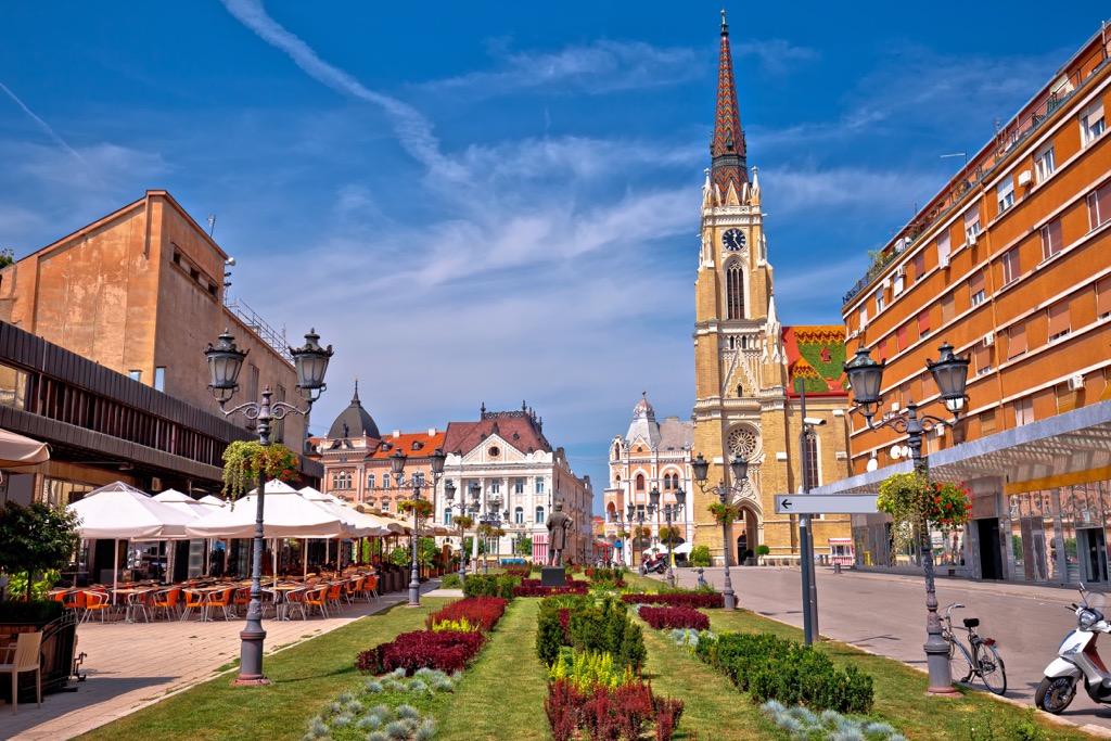
The city got its name from the River Sava. Novi Sad is a place where you can get to know more about Serbian culture and history. There are many museums, galleries, restaurants, and bars that offer an insight into Serbian life.
It is a city in southwestern Serbia. Niš is the third largest city in Serbia, with a population of about 200,000. It is located in the western part of the country near the border with Romania and Bulgaria.
It is one of the oldest cities in Serbia, with a history dating back to the Neolithic period. Niš has been an important crossroads between East and West since ancient times and became one of the most important cultural centers in south-eastern Europe during antiquity.


Yes. Serbia has 6,388 named mountains. The highest is Midžor at 2,169 m.
The highest mountain in Serbia is Midžor, at 2,169 m.
Serbia has 6,388 named mountains.


