Scan the QR code and open PeakVisor on your phone
Latina is one of the five provinces of the Lazio region of central Italy. It is home to the city of Rome, which is the capital of the Lazio region, and its main feature is its magnificent landscape, which includes everything from a large plain to mountains, island archipelagos, and a seemingly infinite number of historic sites. There are 279 named mountains in Provincia di Latina. The highest and the most prominent mountain in Latina is Monte Petrella (1,533 m / 5,029 ft).
The name of the province of Latina (Provincia di Latina) comes from the name of its provincial capital and largest city, Latina.
The name was given to the city in 1944 and it comes from the Latin term Latium. This was the name given to this area by the Latins (Latini), an Italic tribe that lived in the areas around Rome before the creation of the Roman Republic.
The province of Latina is the smallest (2,251 sq. km / 869 sq. mi) in area among the five provinces of the Lazio region of central Italy. But it is the second most populous (561,000 people) province in the region after Rome (2.7 million people), which is located to the south.
Latina borders the province of Rome to the northwest and north, and the province of Frosinone to the northeast and east. In the south, the province's borders are defined by the Tyrrhenian Sea.
The province also includes a few island territories, namely, the Pontine Islands, which is a small archipelago of six islands that’s located 12 nautical miles (22 km / 13.6 mi) off the coast.
The largest island in the archipelago is Ponza (3,360 inhabitants), the other five are Palmarola, Zannone, Gavi, Ventotene (700 inhabitants), and Santo Stefano. That said, four of the six islands in the archipelago are uninhabited.
The distance from Rome to Latina is exactly 70 km (43.4 mi) or about 4 hours by car. The road is almost straight, so the drive is very simple.
If you prefer to travel by public transport, the fastest and most comfortable way to get to the provincial capital and other towns is by Trenitalia trains. Within the province, especially in the southeast, where the main natural attractions and hiking areas are located, you can travel easily using Trenitalia trains and the buses of the local company Cotral.
The landscape of the Latina province can be called extremely diverse. In fact, there is a little bit of everything in the province for visitors to enjoy.
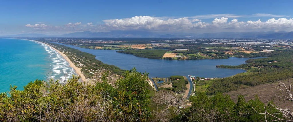
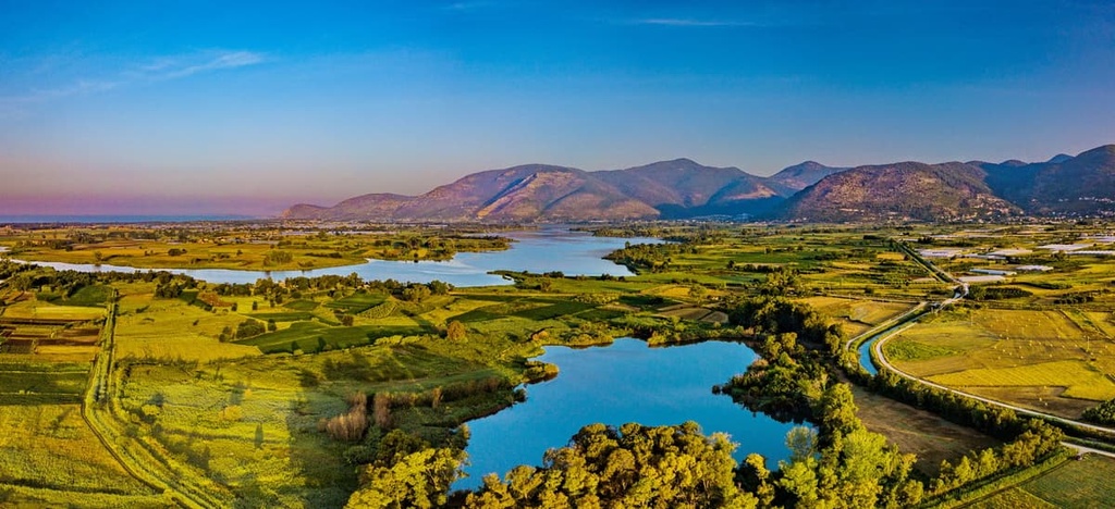
Along with the Pontine Islands, the province is home to the Pontine Plain, which is also known as the Pontine Marshes, a dense forest (Selva di Circe), and four large lakes: Sabaudia (Paola), Caprolace, Monaci, and Fogliano.
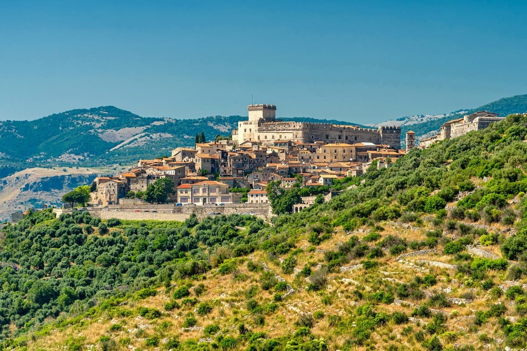
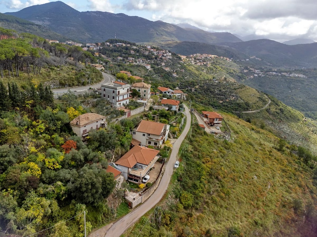
Additionally, the province is home to the mountain range of the Volsci Mountains (Monti Volsci); and many picturesque promontories (Circeo, Terracina, Sperlonga, and Gaeta, among others) along the coast of the Tyrrhenian Sea. There are also many medieval towns in the province, almost all of which are situated within a huge fortress with defensive towers.
The many capes in the province are also known for their numerous grottoes, including the grotto named after the second Roman Emperor Tiberius. Tiberius’ villa was located next to this grotto, though it is now part of the Grotto Tiberius Museo Archeologico. As a result, the grotto is not only an interesting site but a very important one for the country and its history.

The province of Latina as an administrative entity is still less than 100 years old, but its history goes so far back that it would require a separate guidebook to describe it. However, the region experienced a handful of distinct periods, including:
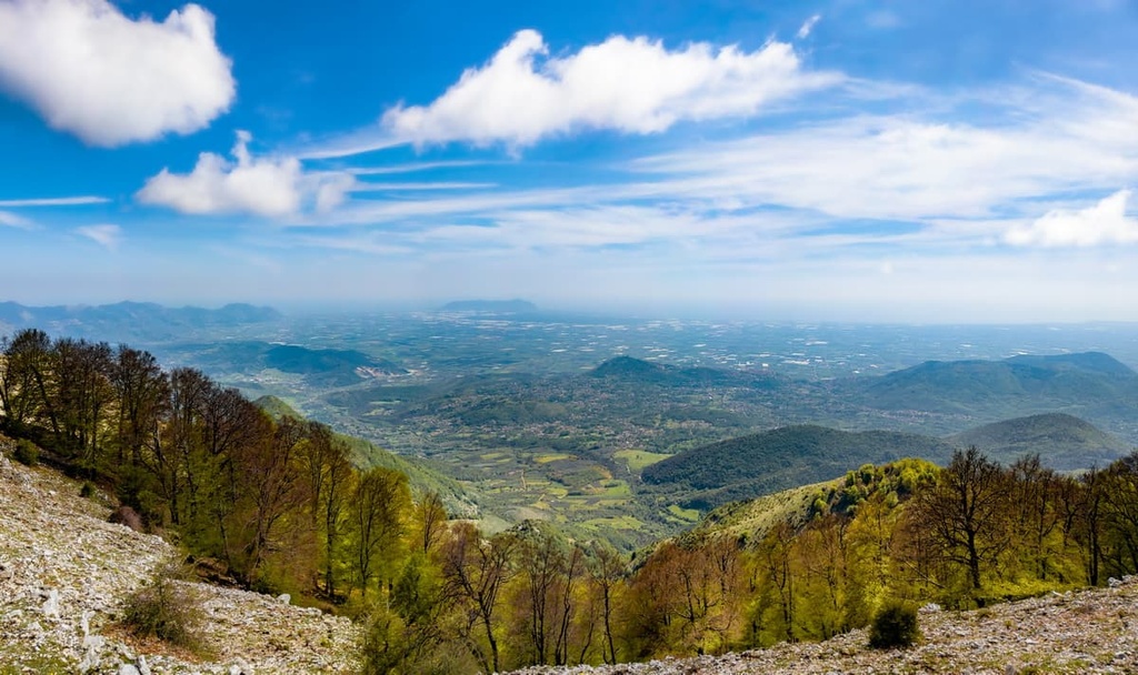
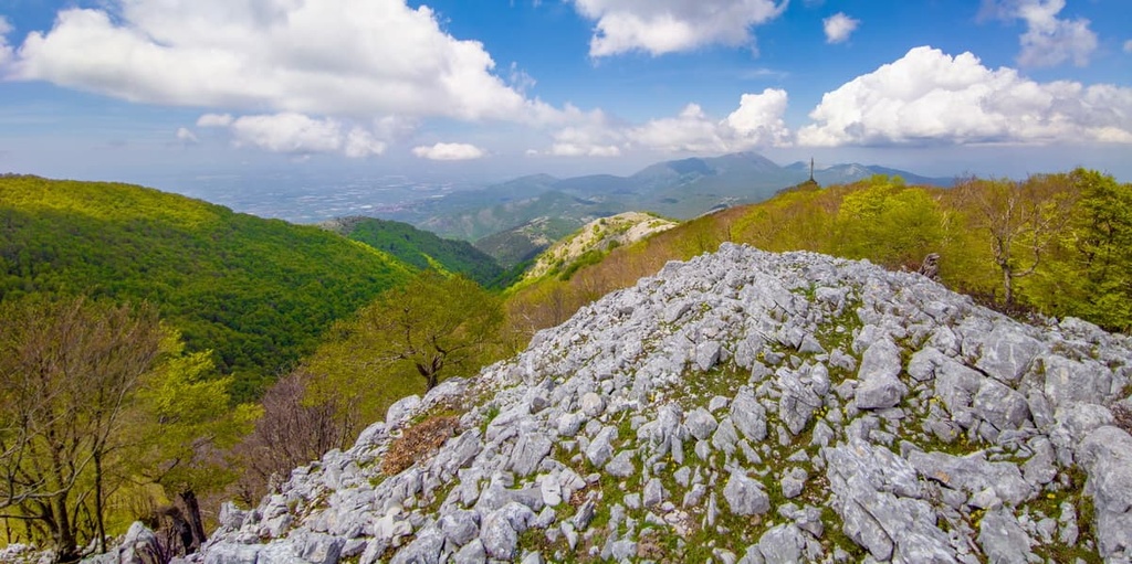
The Volsci Mountains (Monti Volsci) are the main and only mountain range in the province of Latina. This range features relatively low mountains that only reach heights of about 1,500 m (4,920 ft) and it is located to the northeast of the Pontine Plain.
To the south, the mountains reach the sea near the towns of Terracina, Sperlonga, and Gaeta, and they cover the entire coast between Sperlonga and Gaeta. Together with a few neighboring mountain groups to the west and east, the Volsci cover about two-thirds of the area between Rome and Naples, so they are quite large with respect to their total size.
The Volsci Mountains belong to the Antiapennines of Latium or Latium Antiapennines (Antiappennino laziale), which are the Antiapennines (Antiappennini) or foothills of the greater Apennines. In some sources, they are also called Preappennines or Subappennines.
Don’t be surprised if this is the first time you see this naming and classification convention for the Apennines. Many people refer to the subsections of the Apennines by their location (i.e., northern, central, and southern), though either classification system is acceptable.

In any case, the Apennines of Latium are a continuation of the Apennines of Abruzzo (Appennino abruzzese), one of the two parts of the Central Apennines on par with the Umbria-Marche Apennines (Appennino umbro-marchigiano).
But much more interesting is the internal division of the group. The Volsci Mountains are divided into three interesting and approximately equal in size subgroups (from north to south), including:
Given the large number of mountains in the province, we will only briefly discuss a handful of interesting summits in this article.
Monte Petrella (1,533 m / 5,029 ft) is the highest peak that’s wholly contained within the province of Latina since the taller Monte Semprevisa is located on the border of Latina and the province of Rome.
In terms of shape, the mountain is nothing special, but it is located next to the sea, so it offers great views of the coastline, the other two mountain subgroups in the Volsci Mountains, and the highest peaks of all the Apennines. On a clear day, you can even see Vesuvio (1,281 m / 4,202 ft) from the top of the mountain.
There is a relatively uncomplicated loop trail from the Valley of the Saints (Valle dei Santi) in the east of the Aurunci Mountain that leads to the summit of Petrella and back. It is about 15 km (9.3 mi) long and it has an ascent of around 1,500 m (4,921 ft). Most people will probably need around 10–12 hours to complete this hike.
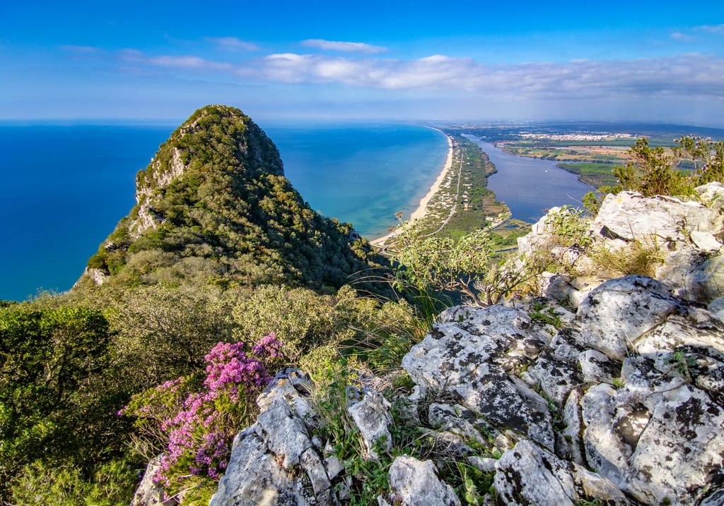
Monte Circeo (541 m / 1,774 ft) is another (and even more) famous peak of the Volsci Mountains. This summit serves as an even better overlook than Petrella as it offers great vistas of the coastline and the entire Pontine Plain.
However, be warned that the trail to the summit is difficult and very rocky. It will take at least 5 hours to complete and will be physically demanding (but the views are worth it).
Monte Pellegrino (194 m / 636 ft), Monte Guardia (285 m / 935 ft), and Monte Guarniere (253 m / 830 ft) are the highest points of three of the six Pontine Islands to the south of Circeo in the Tyrrhenian Sea. You can climb them during a walk around the islands, which you can get to via ferry from Formia.
Colle del Cavaliere (55 m / 180 ft) is another interesting peak of Latina Province. It is very small compared to the others, but it is the highest point of the Pontine Plain itself. Moreover, it is located in the center of the plain, so its views of the region are unparalleled.
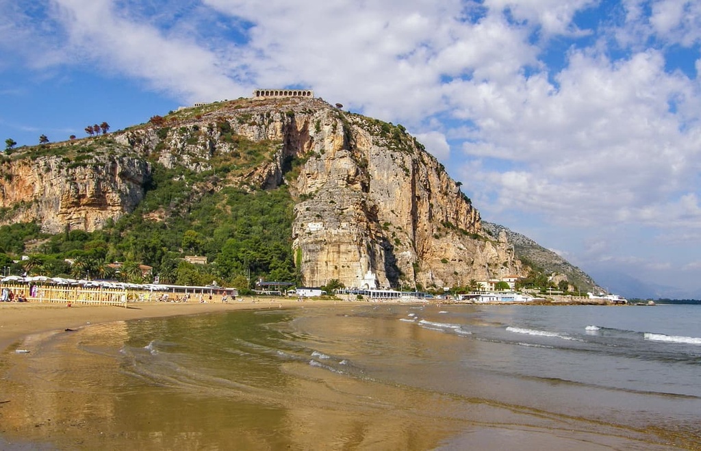
Other notable peaks in the province include Pisco Montano (100 m / 328 ft) and Monte Glove (229 m / 751 ft), both of which are located in the city of Terracina. Pisco Montano features an incredible rocky summit while Monte Glove towers above the whole town.
Additionally at the top of Monte Glove is the Temple of Jupiter Anxur (Tempio di Giove Anxur)—an ancient Roman temple that dates back to the first or second century BCE. This temple was dedicated to Jupiter, the god of the sky and thunder, and king of all the gods in Roman mythology.
Monte San Magno (489 m / 1,604 ft) is another great viewpoint on the Tyrrhenian Sea that’s located near the beautiful town of Sperlonga. It is suitable for those who are staying in the town but don’t want to climb the higher Monte Petrella and the more difficult Monte Circeo. You can reach the summit of Monte San Magno via a fairly casual marked hiking trail.
The province of Latina is home to a seemingly infinite number of nature parks and hiking areas, despite its relatively small size. It is also home to an ancient road that serves as an excellent hiking adventure. Here’s what you need to know about the best hikes in the province of Latina before your next trip to the region.
Circeo National Park is one of the 25 national parks of Italy and one of the four oldest parks in the country as it was founded in 1934. This park is located on the seashore and is easily accessible from the surrounding area.
Its main feature is the combination of five natural areas, including the Monte Circeo, the Mount Circeo Promontory, the Tyrrhenian Sea coast and its sand dunes, the selva forest, and one of the Pontine Islands.
In addition, the place that is now part of Circeo National Park appears in Homer’s epic poem, The Odyssey. It served as one of Odysseus’ stops on his journey from Troy (in modern-day Turkey) to Ithaca in Greece. The park’s main trail is 7 km (4.3 mi) long and it leads through Mount Circeo to the seashore.
Circeo National Park also includes several small nature reserves, the main of which is the aforementioned selva forest.
This forest is part of the Riserva naturale della biosphere UNESCO “Selva di Circe.” As its name suggests, the reserve is also a UNESCO nature site, and its stunning forests are well worth checking out.
All three mountain groups within the Volsci Mountains are part of nature parks that feature many excellent trails. These include:
The fourth main provincial nature park is the Parco regionale naturale "Riviera di Ulisse" (Ulysses is the name of Odysseus in Latin), which includes almost the entire coastline between Sperlonga and Gaeta.
The main natural attractions of this park are its rocky promontories and mountains, as well as the seashore itself. In particular, there are three distinct locations in the park: the Grottoes of Tiberius in Sperlonga, Monte Orlando in Gaeta, and Gianola e Monte di Scauri further along the coast to the east of the town of Formia.
Along the park, there is also the “Sentiero di Ulisse,” a walking and hiking route that runs along the edge of the sea. Unfortunately, because of the capes, you can’t walk the whole length of the coastline, but you can hike along sections of it.
Visitors to Latina Province can also hike in the province’s many natural monuments. The most famous monument in Latina is the huge lone rock standing on top of the mountain above the town of Terracina, which is called Monumento naturale Camposoriano.
Other notable monuments in the province include:
The province of Latina is crossed by several famous long hiking trails, most of which follow roads that were constructed by the Romans thousands of years ago.
Via Appia
The most important of these roads is the Appian Way (Via Appia), which is one of the earliest of the many Roman state roads. It leads from Rome to Brindisi in the province of Apulia on the Adriatic Sea.
The road is not hard to recognize—it’s paved with cobblestones. There are also Roman milestones on the road that used to be placed a mile apart (only a small number have survived) as well as modern markers that tell you that the road still exists.
In particular, there is a 2.5 km (1.5 mi) long section of the road that has been specially restored to showcase the importance of the Via Appia in the history of Rome. There are more than a dozen informational signs located along this section, too.
The entrance to this section of the road is located exactly midway between the towns of Fondi and Itri. It is situated on the SS7 road near Fortino S. Andrea, just to the north of the small settlement of Vastomano.

Via Francigena
The Via Francigena is the second most famous hiking road that runs through the province.
It starts from the cathedral city of Canterbury in England and travels through France and Switzerland on its way to Italy. The road originally ran only to Rome, but it was extended into the province of Apulia, so today it largely coincides with the Via Appia in the province of Latina.
The road is marked with a special sign that indicates its status as a pilgrimage route, and it is considered to be a kind of counterpart to the more famous Camino de Santiago in northern Spain.
On the way, you can spend the night in special shelters for free or for a small fee. Most of these shelters are located in monasteries, fortresses, and the like.
When traveling through the province of Latina, be sure to visit one of its official tourist centers and info points, which are located in almost every major city or resort. You can also check out the visitor's centers of the province’s national and nature parks.
La Riviera d'Ulisse—IAT Latina
Largo Jacopo Peri, 70, 04100, Latina, LT, Italy
+390773480672
Associazione Pro Loco Sabaudia
Piazza del Comune, 18/19, 04016, Sabaudia, LT, Italy
+390773515046
Terracina Infopoint
Viale della Vittoria, 31, 04019, Terracina, LT, Italy
Sperlonga Turismo
Via Municipio, 9, 04029, Sperlonga, LT, Italy
+390771557524
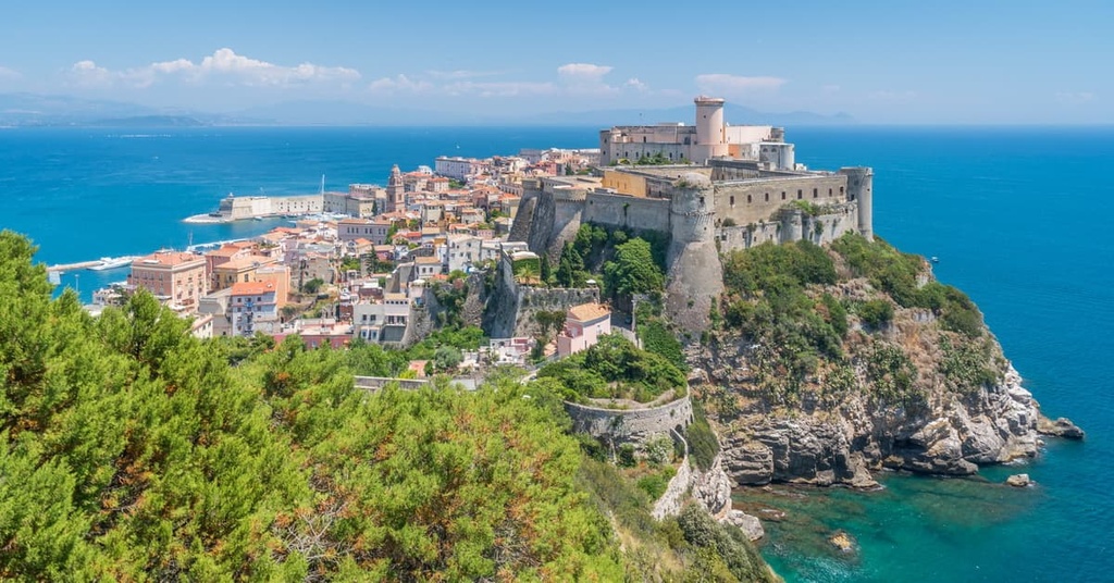
Gaeta Turismo
Piazza 19 Maggio, 10, 04024, Gaeta, LT, Italy
+3907714691
Pro Loco San Felice Circeo
Piazza Lanzuisi, 1, 04017, San Felice Circeo, LT, Italy
+390773 547770
Pro Loco Formia
Via Vitruvio, 196, 04023, Formia, LT, Italy
prolocoformia.segreteria@gmail.com
Facebook.com/proloco.formia.it

Unlike in the Alps and the other larger mountain regions of Europe, in the mountains of the province of Latina, there is no unified system of mountain huts where you can sleep and eat.
Even if you notice that there are places called rifugio in Latina, they may not be mountain huts in the traditional sense, but rather free shelters or restaurants that don’t offer accommodation.
As a result, it’s best to use more traditional lodging options when in the province, especially since the small size of the local Volsci Mountains allows you to plan your route so that you can spend the night in towns and villages on the borders of the parks. The accommodation options here are almost endless, too, from hotels and B&Bs to agrotourismos and campgrounds.
From my experience, a regular B&B is the least expensive option. For example, in Circeo National Park, you can stay overnight at the B&B CircEea at the foot of the mountain of Monte Circeo. Or, if you’re in Aurunci Nature Park, you can stay at the B&B Da Mariella on its eastern borders. The entire Riviera di Ulisse is literally dotted with B&Bs and other types of lodging.
The provincial capital and the largest city in the province of Latina is the city of Latina, which has a population of around 127,000 people. The city is located 62 km (39 mi) to the south of Rome in the northern part of the province at an elevation of 21 m (69 ft). A total of 560,000 people live in the province.
The city was founded in 1932 in order to drain the Pontine Marshes, something that all the Roman emperors failed to do for several thousand years. This was made possible only in the second half of the twentieth century thanks to the enormous efforts of settlers from the northern regions of Italy, in particular, from Veneto, who formed the basis of the future population of the city.
Additionally, the city of Latina includes the smaller settlements of Latina Lido, Latina Scalo, Borgo Bainsizza, Borgo Carso, Borgo Faiti, and Borgo Grappa, among others.
What makes Latina different from other cities in Italy is that it was built entirely according to a single plan in rationalist style. As a result, the architecture of the city is dominated by strict forms and minimalism, though there are also some large structures in the area that dominate the landscape.
The main architectural and cultural attractions of the city are the Civil Tower (Torre Civica) of the Latina Municipality in People's Square (Piazza del Popolo); the fountain (La Fontana) in the same square; Latina Cathedral of Saint Marc (Cattedrale di San Marco), which was named after the famous patron saint of Venice; and the Post Office Palace (Il Palazzo delle Poste), which was built in a futuristic style.
Another thing that makes this city special is that, inside the city of Latina, there are several parks, which are usually not many in classic Italian fortress-like cities with narrow streets. These parks include Falcone Borsellino Park, Santa Rita Park, and San Marco Park.
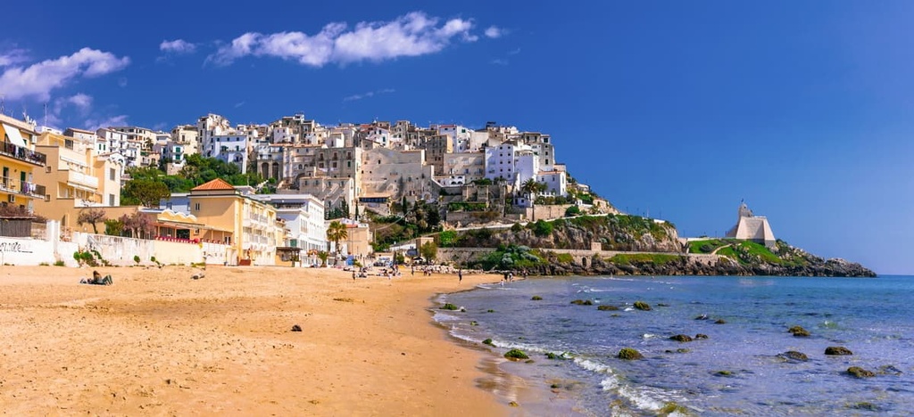
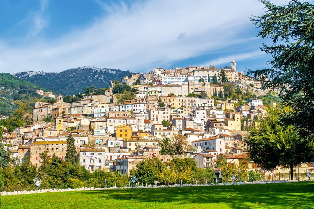
In addition to Latina, the five largest cities in the province in terms of population are Aprilia (74,000), Terracina (46,000), Fondi (40,000), and Formia (38,000). Terracina, which is located on the coast, is the largest and most important resort in the province. Thanks to the Old Town with its many Roman ruins, it is also known to travelers that live far beyond this region.
Other major towns in the province that are also popular resorts include Gaeta, Sperlonga, and San Felice Circeo on the coast, Sabaudia on the Pontine Plain, and Minturno and Itri in the mountains.
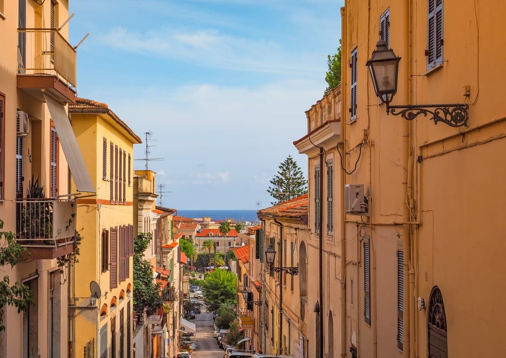
I personally recommend Sperlonga as it is perhaps the most beautiful of all these towns and because it is very small and quiet. But be prepared for the fact that Sperlonga looks more like a village with only one supermarket and not many other services. Transport links to the city are also limited, though it is an excellent town to visit if you do happen to be in the region.
For more information, check out the official tourist site of the province of Latina: ProvinciaLatina.com.