Scan the QR code and open PeakVisor on your phone
Guangxi (广西, Guǎngxī) is an autonomous region located in southern China that features dramatic karst peaks, world-class rock climbing and 264 named mountains. The highest point in the region is Zhenbao Ding (2,125 m/6,972 ft) and the most prominent mountain is Mount Shengtang (1,905 m/6,250 ft).
Located in southern China, Guangxi is one of the country’s premier hiking destinations. The region is known for its surreal rock formations, steep peaks, and incredible river valleys.
Guangxi extends from China’s border with Vietnam in the west to Guangdong province (广东, Guǎngdōng) in the east and from Hunan (湖南, Húnán), Guizhou (贵州, Guìzhōu), and Yunnan (云南, Yúnnán) provinces in the north to the Gulf of Tonkin in the South China Sea.
Guangxi is highly mountainous, with nearly 40 percent of its land area covered steep karst mountains and hills. The region’s name literally means “western expanse,” a reference to its rugged terrain and historical seclusion within China.
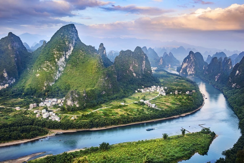
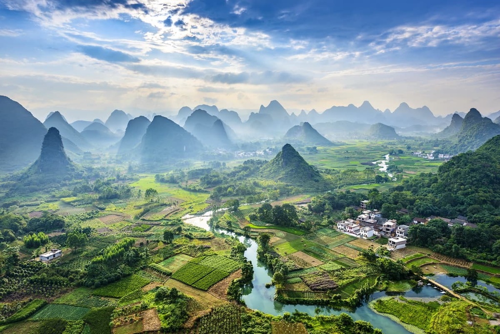
Although Guangxi may have been historically isolated, its landscapes are some of the most famous and visited in China by both foreign and domestic tourists. In fact, a scene of karst peaks towering over the Li River (漓江, Lí Jiāng) in northern Guangxi graces China’s 20 RMB note.
The formal name of the region is the Guangxi Zhuang Autonomous Region (广西壮族自治区, Guǎngxī Zhuàngzú Zìzhìqū), which is a reference to the Zhuang people (壮族, Zhuàngzú; Zhuang: Bouxcuengh), China’s largest minority ethnic group. About 14 million of Guangxi’s 50 million residents are ethnically Zhuang.
The Zhuang language is spoken widely throughout the region, in addition to Cantonese and the southwestern dialect of Mandarin. Only about 60 percent of Guangxi’s population is ethnic Han Chinese, the lowest percentage of any of China’s provinces.
As an autonomous region, Guangxi has more legislative rights and independence than a province. While some autonomous regions in China have travel restrictions for foreigners, no special visas or permits are required for traveling in Guangxi.

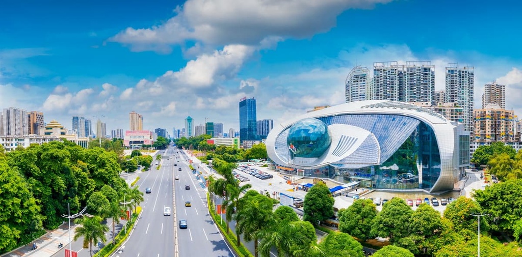
The capital and largest city in Guangxi is Nanning (南宁, Nánníng), which is located in the southeastern part of the region. Other major cities in Guangxi include Guilin (桂林, Guìlín), Liuzhou (柳州, Liǔzhōu), and Yulin (玉林, Yùlín). Despite the fact that it contains large cities like Nanning, almost 50 percent of Guangxi’s population lives in rural areas, with most of the population concentrated in the eastern half of the region.
In the past two decades, Guangxi has become a major tourist destination for both foreign and domestic travelers. Guilin and nearby Yangshuo (阳朔, Yángshuò) county, with their dramatic karst mountains, are the main tourist draws in the region.
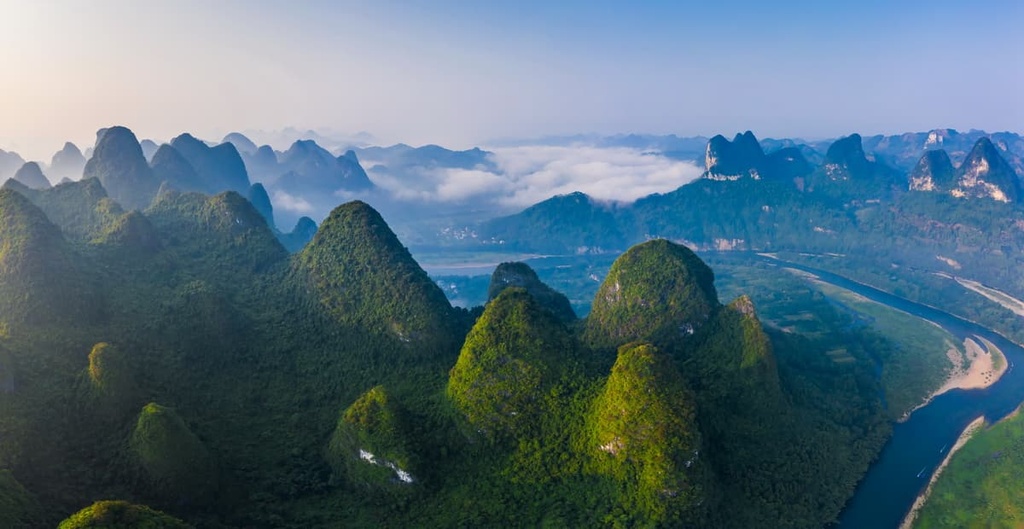
Guangxi’s most dominant geological feature is its incredible karst landscapes, which cover almost 40 percent of the region. Jagged mountains, deep river valleys, and massive cave systems dot the area, making it a destination for hikers and climbers alike.
Kast landscapes like those in Guangxi are created when soluble rock is dissolved by water through erosion, creating dramatic sinkholes, pillars, cave systems, and other unusual formations. In Guangxi, most of the karst landscapes consist of limestone.
The Guilin karst area in northeastern Guangxi lies within a large basin. Heavy rainfall and abundant water runoff from the surrounding hills made the development of Guilin’s “tower and cone” karst formations (called fenglin and fengcong in Chinese) possible. The Guilin Karst area, which lies within Lijiang National Park (漓江景区, Líjiāng jǐngqū), is considered one of the world’s best examples of continental fenglin karst.
In fact, Guangxi’s karst landscapes are so significant that they were designated as a UNESCO World Heritage site in 2014. The Guilin Karst area is one of the seven core zones of the South China Karst Area, which covers a massive space of about 550,000 sq km (210,000 sq mi) across Guangxi, Guizhou, Yunnan, and Chongqing.
In addition to karst formations, Guangxi is home to more than a half dozen mountain ranges and subranges, including the Nanling Mountains (南岭, Nán lǐng) which separate central and south China.
The Nanling Mountains are sometimes referred to as the Wuling Mountains (五岭, Wǔlǐng), which translates to “five mountains” in Chinese, a reference to the five major ranges of the Nanling. In Guangxi, the highest peaks are found in the Yuecheng Mountains (越城岭, Yuèchéng Lǐng), a subrange of the Nanling.
Other Nanling subranges in Guangxi include the Haiyang (海阳山, hǎiyáng shān) and Duopang (都庞岭, dūo páng lǐng) mountains. This region is home to the Xianggui Corridor (湘桂走廊,Xiāngguì zǒuláng), which was historically one of the most important transportation corridors in China. The corridor provides a passible route through the mountains from south to central China.
Elevations in Guangxi reach highs of about 2,100 m (6,500 ft) on the Yunnan-Guizhou plateau in the northeast and the Duoyang mountains in the west of the region and gradually fall as you move south through the region. The lowlands in southern Guangxi are still hilly, but only reach elevations of about 450 m (1,500 ft).
The highest point in the region is Zhengbaoding, a subpeak of Kitten Mountain (猫儿山, Māo'ér Shān), which lies in the Yeucheng Mountains. The most prominent peak is Mount Shengtang.
Guangxi has a humid subtropical climate, with extremely hot summers lasting from April through October. Winters are mild and the southern reaches of the region experience typhoons. The annual average temperature in the region hovers around 20°C (68°F).
Spring and early fall are the best times to visit, when temperatures are more mild and humidity isn’t as extreme.
In terms of plant life, nearly a quarter of Guangxi is covered by forests. Timber is a major industry in the region. Common trees include red pine, cedar, rosewood, camphor, and cassia. Anise trees are also very common in Guangxi. In fact, the region produces 85 percent of the world’s star anise.
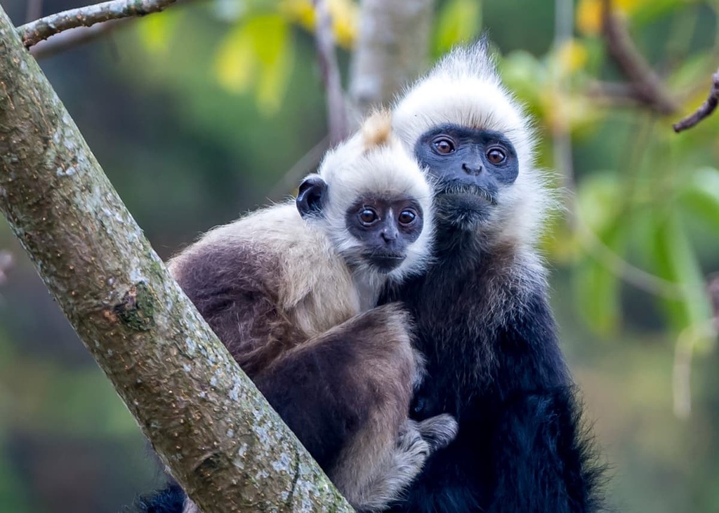
Guangxi is also home to a number of endangered animals. One of the most notable is the eastern black-crested gibbon, which is considered one of the rarest primates in the world. There were no sightings of the species between the 1960s and 2000s. In 2006, a small population was found for the first time in Guangxi. It’s estimated there are only about 250 of the animals remaining across Vietnam and China today.
François' langur is another extremely rare primate found in Guangxi. This langur favors the karst habitats in Guangxi and northwestern Vietnam. It’s estimated that only about 1,500 remain in the wild in China.
The warm waters off the southern coast of Guangxi are home to dugongs, a close relative of the manatee. They’re the only sirenian (or sea-cow) found in Asia and they can live up to 70 years.
Although the Han Chinese are the largest ethnic group in Guangxi, they make up a smaller share of the population of Guangxi than any other province in China as they account for only about 60 percent of Guangxi’s residents.
Guangxi was historically part of the area of the “Baiyue,” or “Hundred Yue Peoples,” a term the Han Chinese used to refer to the myriad ethnic groups in southern China. The most prominent ethnic group in Guangxi for at least the past 2,000 years has been the Zhuang people.
The region which became Guangxi was first conquered by the Chinese empire during the Qin dynasty in 214 BCE, although the Qin dynasty collapsed shortly thereafter.
Control of the region alternated between the local Zhuang, broader southern kingdoms, and the central Chinese empire for most of the next two thousand years. The Zhuang people were consistently resistant to outside rule.
Guangxi was officially made a province under the Yuan dynasty, but direct central rule wasn’t imposed until 1726 CE under the Qing dynasty. As the Qing dynasty crumbled in 1911, Guangxi seceded from the empire and warlords dominated the province for much of the next two decades.
Chiang Kai-shek brought the province under the control of the Republic of China in 1929, but his forces ultimately lost the Chinese Civil War and the Red Army took control of Guangxi in late 1949, making it a province of the People’s Republic of China. Guangxi province became an autonomous region in 1958.
Guangxi is one of China’s major outdoor destinations, drawing hikers and climbers alike to its steep peaks. Here are some of the best hiking areas in the region to check out during your next trip.
Guilin is the jumping-off point for most travelers coming to Guangxi. While most of the best hiking is south of the city, there are a few good hiking trails in the city limits. For example, Seven Star Park in central Guilin has several steep limestone hills that offer great views over the city.
Further afield, Bajiazhai National Park, located 150 km (90 mi) north of the city, offers some of the most spectacular Danxia landscapes anywhere in China. There are stairs and hanging “cliff walks” built into the sides of the mountains, allowing you to climb the near-vertical rock formations.
Bajiaozhai National Park lies on the border with Hunan, and you can enter the park from either region. Be aware that the entry ticket is 38 yuan if you enter in Guangxi and up to 186 yuan if you enter in Hunan, so it’s cheaper to visit the Guangxi side.
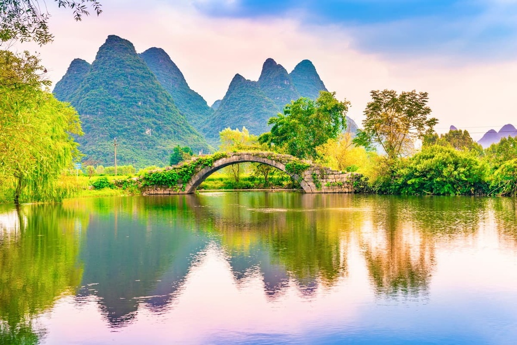
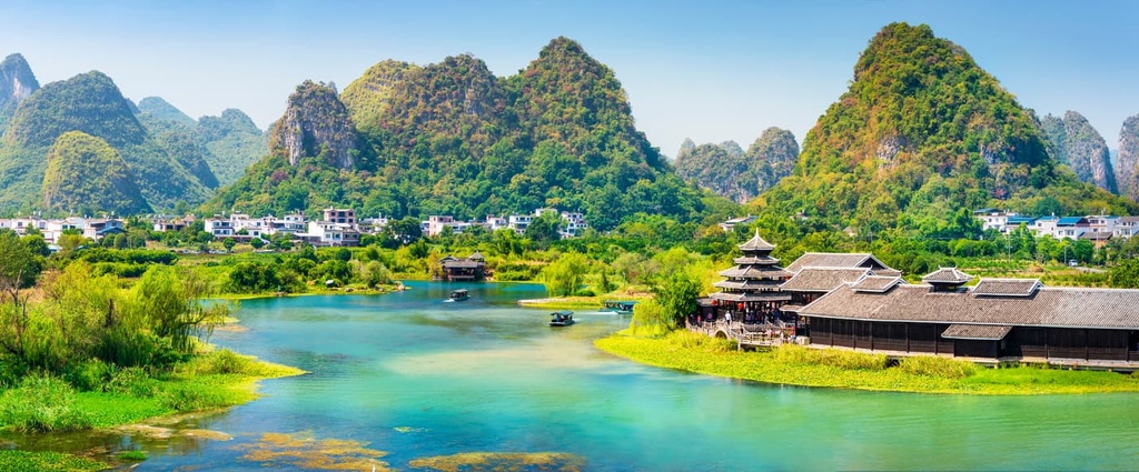
Located to the south of Guilin, the tourist corridor through Yangshuo County to the city of Yangshuo is easily the most visited (and most accessible) area of Guangxi.
The corridor follows the Li River through stunning karst scenery and tourist-oriented villages to the small city of Yangshuo. The main villages along the river with tourist amenities are Caopingshan (草坪乡, Cǎopíngxiāng), Yangdixiang (杨堤乡, Yáng dī xiāng), and Xingpingzhen
(兴坪镇, Xìng píng zhèn).
Most tourists opt to raft a section of the Li River, but you can also hike along the banks for equally stunning views and a more up-close look at the local farming villages. The hike is about 16 km (10 mi) long and it’s a great way to get off the beaten tourist track.
If you’re interested in hiking, Xingping town offers the best nearby trails, as well as plenty of hotels, hostels, and options for bike and motor scooter rentals. Laozhaishan (老寨山
Lǎo zhài shān) is a short but extremely steep hike with amazing views over the town and the Li River.
Situated further south is Yangshuo City, which is a much larger town with more options for accommodation and dining, as well as several excellent hikes. Moon Hill (月亮山, Yuè Liàng Shān), which is located about 8km (5 mi) south of town, is the most popular of these trails. The hill is actually a massive arch that’s popular with rock climbers. A short, steep trail leads to the bottom of the arch.
Green Lotus Peak is another great hike that’s located right in town. It makes for a great sunrise or sunset hike, although it costs 30 RMB to enter the trail.
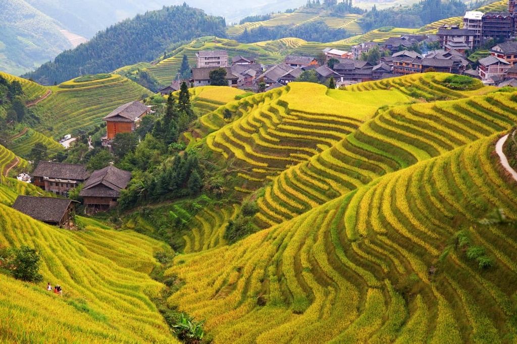
After Yangshuo, the most popular destination in Guangxi is the Longji Rice terraces (龙脊梯田,lóngjǐ tītián), which are also called the Longsheng Rice Terraces (龙胜梯田, lóngshèng tītián).
The terraces cover a series of steep hills dotted with small farming villages that are primarily home to ethnic Zhuang (壮, Zhuàng; Zhuang: Bouxcuengh) and Yao (瑶族, Yáo) people. It’s a great destination for anyone interested in seeing a more traditional way of life in the Chinese countryside and learning about the history of and culture of Guangxi.
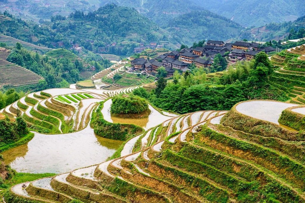
There are two main areas of the rice terraces: the Ping’An Area (平安壮寨梯田, Píng'ān zhuàng zhài tītián) and the Jingkeng-Dazhai Area (金坑大寨红瑶梯田, Jīn kēng dà zhài hóng yáo tītián). While both are stunning, the Jingkeng area is less developed, despite hosting a cable car to one of the highest points in the terraces. The terraces in the Jingkeng area are larger and more dramatic.
Hiking in the Longji Rice Terraces can be strenuous (think hundreds of stone steps) but the views are amazing and it’s one of the most unique places you can hike in China. One shorter hike in the Ping’An area leads from Ping’An village to Longji village in about two hours, passing through the Seven Stars around the Moon viewpoint.
The premier hike in the Longji Terraces links the Ping’An and Jingkeng areas together via a trail between Ping’An and Dazhai villages. This trail takes at least 4 hours to complete, so it makes a great full day hike. If you start your day in Ping’An, you can hike to the Jingkeng area, visiting the viewpoints and stopping for lunch in a village along the way before catching a ride out of Dazhai (大寨, dà zhài).
Rock climbing is becoming increasingly popular in China and Yangshuo has since become an international climbing destination. There are over 400 graded climbs in Yangshuo ranging from 5.6 to 5.13, and new climbs are frequently established.

There are agencies offering beginners’ climbing courses out of Yangshuo. The area has a great range of climbs, from beginner-friendly to extremely technical world-class routes. Some of the most famous traverse the arch on Moon Hill.
Of the larger cities in Guangxi, Nanning, Guilin, and Beihai offer the most for visitors. Here’s what you need to know before your next trip.
Nanning (南宁, Nánníng) is Guangxi’s capital and largest city. It’s a major transportation hub and home to over 7 million people. Within the city, Nanhu Lake and Mt. Qingxu offer the best opportunities for scenic hiking. Mt. Qingxu is especially popular in the early spring when the peach trees are in bloom.
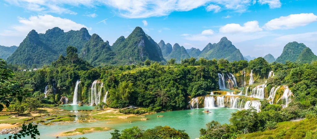
Nanning is also the best jumping-off point for trips to the Detian Waterfall (德天瀑布, Détiān Pùbù), the largest transnational waterfall in Asia. Located about 150 km (90 mi) from Nanning, the falls straddle the border between Vietnam and China (they’re known as the Ban Gioc Falls in Vietnamese).
The falls are tiered and feature a number of individual waterfalls between the different levels. They’re about 200 m (650 ft) wide and 70 m (230 ft) tall.
If you’re coming to Guangxi, there’s a good chance you’ll be passing through Guilin (桂林, Guìlín). While Yangshuo is the major destination in the region, Guilin is definitely worth a day or two of your time.
The city is more laid-back and relaxed than most Chinese cities, with beautiful tree-lined streets and Guangxi’s famous karst peaks framing the landscape. One of the best places for a walk is the Sun and Moon Pagodas (日月双塔, Rìyuè Shuāngtǎ) in Riyue Shuangta Cultural Park, which are rebuilt versions of historic Tang pagodas. They’re lit up beautifully at night.
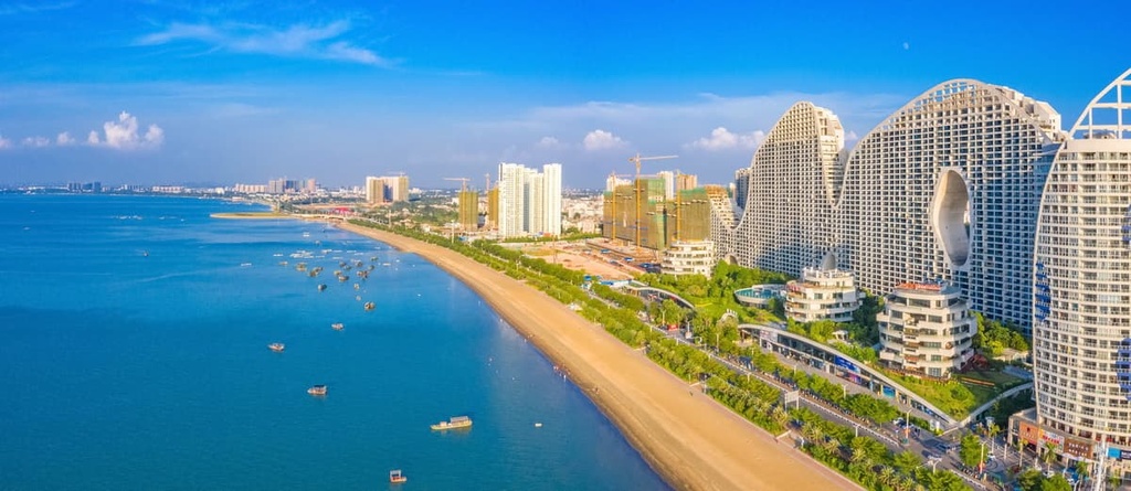
Although China is not know for great beaches, some of the best beaches in the country can be found in Beihai (北海, Běihǎi). The city also features historic examples of western architecture and excellent Cantonese and Vietnamese food.
Silver Beach is one of the most famous beaches in China and it’s easily accessible from within the city. For even better and more secluded beaches, head further afield to the islands of Weizhou or Xiyang in the Gulf of Tonkin.