
Scan the QR code and open PeakVisor on your phone
Guangdong is home to 1,908 named mountains. The highest is Shikengkong at 1,902 m.
Guangdong (广东) is a diverse and dynamic region in southern China that boasts a rich natural and cultural landscape. There are 1908 named mountains in Guangdong. The highest and the most prominent mountain is Shikengkong (石坑崆 1,902 m / 6,240 ft).

Guangdong is a coastal province in southeast China, occupying 179,700 sq. km (69,400 sq. mi). It shares boundaries with the provinces of Hunan, Jiangxi, and Fujian to the north and Guangxi to the west.
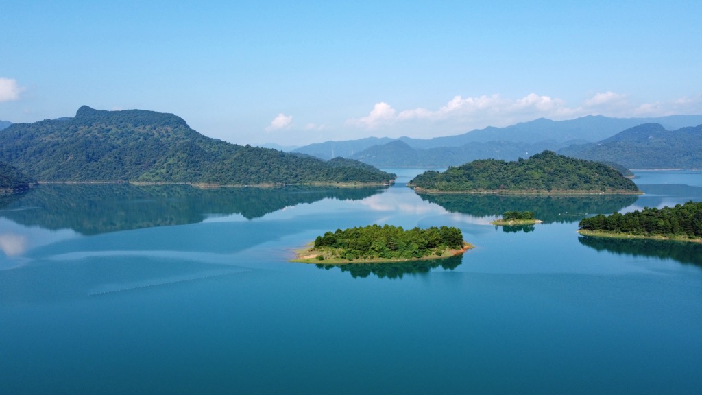
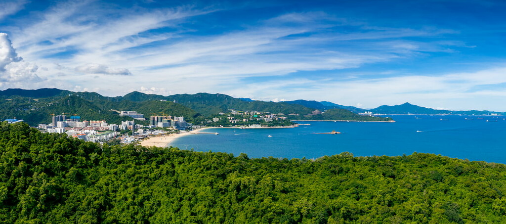
On the southeastern side of the province, a sinuous coastline stretches along the South China Sea for more than 4,000 km (2,485 mi), the longest among all Chinese provinces. There are more than 600 islands off the coast.
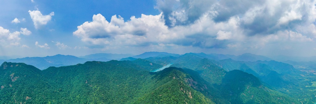
The northern part of Guangdong is mountainous, while the southern part consists primarily of coastal plains, alluvial valleys, rounded hills, and urban areas. The most extensive mountain range in the province is the Nanling (南岭), though only parts of it are in Guangdong.
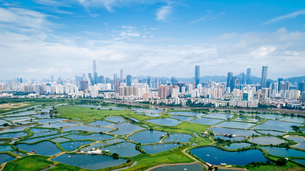
The most important waterway in Guangdong is the Pearl River (珠江), originating from Yunnan province. Its three main tributaries–the East River, West River, and North River–converge to form the Pearl River Delta, where several cities have merged into the world's largest contiguous urban area with a population of over 66 million.

The biggest cities in Guangdong are the provincial capital, Guangzhou (广州), also known as Canton), and the coastal city of Shenzhen (深圳), both of which are in the Pearl River Delta. They are among the four first-tier cities in China, the other two being Beijing and Shanghai.
Nine major Guangdong cities in the Pearl River Delta, including Guangzhou and Shenzhen, and the Special Administrative Regions of Hong Kong and Macau (not governed by Guangdong), comprise the Greater Bay Area (大湾区).
Situated between the latitudes of 20°09′N and 25°31′N, Guangdong has a predominantly subtropical climate. The annual precipitation is about 1,500 - 2,000 mm (60 - 80 inches), most of which falls in the summer. The coastal region is prone to typhoons between July and September.
A combination of mountainous terrain, sedimentary basins, volcanic activity, coastal features, and fault systems marks Guangdong's geology.

The Nanling Mountains in northern Guangdong are the most prominent geological feature. Spanning across a few provinces in southern China, the range consists of primarily metamorphic rocks like schist, gneiss, and marble formed as a result of intense heat and pressure. The region has undergone multiple phases of uplift and erosion that gave rise to deep valleys, rugged peaks, and steep slopes, as well as faults and fractures that intersect the mountains.
The Pearl River Delta in southern Guangdong is a low-lying, fertile plain formed by sedimentation. This delta region has a thick layer of alluvial deposits, including clay, silt, and sand accumulated over millions of years. It is an ever-changing environment with ongoing processes of deposition, erosion, and reworking of sediments. The region is prone to land subsidence due to the compaction of soft sediments and human activities such as groundwater extraction.
Sandy beaches, rocky shores, and estuaries characterize the extensive coastline. The region is influenced by sea-level changes, which have led to the development of numerous coastal features over geological time, such as rias, which are inlets the sea has partially submerged.
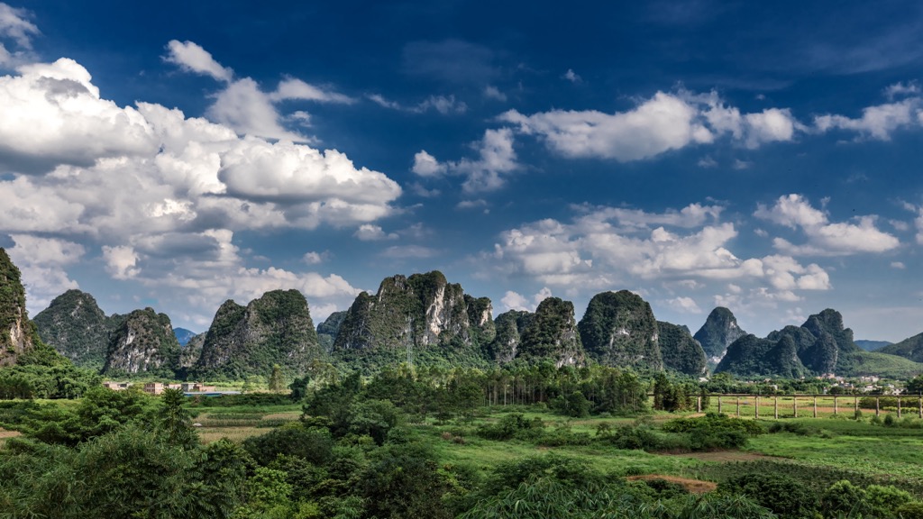
Parts of Guangdong, particularly in the northern areas near Guangxi, exhibit karst topography characterized by limestone formations, resulting in numerous caves, sinkholes, and underground rivers.
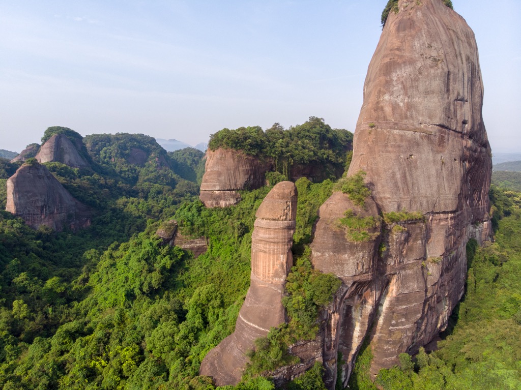
Another type of topography in Guangdong is the Danxia landform, caused by the deposition and erosion of different sedimentary rocks, including sandstone and conglomerate. The mineral content and oxidation processes give the rocks distinctive reddish hues. The landform is named after Danxiashan (丹霞山) in Guangdong, where it was first identified, though it is present in other parts of the country.
Guangdong is intersected by several fault systems, such as the Red River Fault Zone (红河断裂带), which have the potential to generate earthquakes. While large and destructive earthquakes are relatively rare in Guangdong, the region does experience occasional seismic events of smaller magnitudes.

Guangdong is home to various types of forests, including subtropical evergreen broad-leaved forests, tropical monsoon forests, coniferous forests, and mangrove forests along the coast. Some notable flora species include camphor trees, Chinese fan palms, and bamboo.
More than a thousand species of terrestrial vertebrates can be found in the province. About twenty are nationally protected animals, including the South China tiger, clouded leopard, and Assam macaque.

The South China tiger is a subspecies that used to roam in a range extending from central China to Hong Kong. However, it is now considered extinct in the wild since it has not been spotted since 1990. Its current population of about 200 is entirely captive-bred.
The coast of Guangdong is a vital biodiversity area, as the South China Sea is one of the significant fish breeding grounds in the world. Common fish include groupers, snappers, jacks, tunas, barracudas, and mackerel.
The South China Sea also harbors sea turtles (including green turtles, hawksbill turtles, and loggerhead turtles), cetaceans (like the Indo-Pacific humpback dolphin, commonly known as the pink dolphin, and Bryde's whale), and sea snakes like the banded sea krait. Moreover, a diverse array of corals, crustaceans, and mollusks thrives.

In addition, Guangdong's coastline is a popular wintering ground for migratory birds such as the black-faced spoonbill, Saunders's gull, and Oriental stork. The coastal areas have extensive wetlands, such as the Neilingding Futian National Nature Reserve(內伶仃島福田國家級自然保護區)and the Guangdong Haifeng Wetlands (广东海丰湿地). They play a vital role in maintaining water quality, preventing coastal erosion, and mitigating the impacts of storms and tidal waves.
As one of China's most developed and populated provinces, Guangdong faces many ecological challenges, such as habitat loss, water pollution, and overfishing. In response, the government has implemented various conservation initiatives, including designated protected areas throughout the province and a seasonal fishing moratorium in the South China Sea.
The region that is now Guangdong has been inhabited since the Paleolithic period. Stone artifacts unearthed at the Yunan Modaoshan Site (郁南磨刀山遗址), the oldest archaeological site in the province, date back 600,000 - 800,000 years ago.
During the Zhou Dynasty (周代 1046-256 BCE), the region was part of the Baiyue (百越), a general term for the multitude of ethnic groups living in southeast China at that time. Being far away from the center of civilization in northern China, those people were considered barbarians.
The region became part of the unified Chinese empire during the Qin Dynasty (秦代 221-206 BCE) when the name “Guangdong” first appeared. Its strategic location along the coast made it an important center for trade and maritime activities throughout the subsequent dynasties. It was a gateway for cultural exchanges with foreign merchants, including Arabs, Persians, and Southeast Asians.
During the Tang (唐代 618-907 CE) and Song (宋代 960-1279 CE) dynasties, Guangdong flourished as a vital hub along the Maritime Silk Road. The province's ports, especially Guangzhou, thrived as cosmopolitan trade centers, connecting China with the rest of Asia and the world. Guangdong's prosperity attracted merchants, scholars, and foreign travelers.

In the 16th century, European powers like Portugal, the Netherlands, and Britain established trading posts in Guangdong. Macau, located in present-day Guangdong, became a Portuguese colony (until 1999) and a vital trading port.
Tensions arose between China and foreign powers during the 18th and 19th centuries. From 1757, Guangzhou was the only Chinese port open to foreign trade. Britain, which suffered from a substantial trade deficit against China, attempted to address the imbalance by exporting opium to China through Guangzhou. This led to the Opium Wars, which resulted in the cession of Hong Kong to Britain (from 1842 to 1997) and the opening of more Chinese ports to foreign trade.
Guangdong played a significant role in China's revolutionary movements during the late 19th and early 20th centuries. It was a stronghold for reformers and revolutionaries, including Dr. Sun Yat-sen (孙中山先生), the founding father of modern China. A Guangdong native, Dr. Sun led the Xinhai Revolution (辛亥革命) that overthrew the Qing Dynasty in 1911.
In the modern era of the People's Republic of China, Guangdong was at the forefront of economic reforms and opening-up policies initiated in the late 1970s. The province underwent rapid industrialization and development, becoming an economic powerhouse with the highest GDP among all Chinese provinces.
Guangdong’s current population is 127 million, about 9% of the national population, even though its land area accounts for less than 2% of China. The native tongue of most people in Guangdong is Cantonese, which is sometimes considered a language rather than a dialect. Some places have other dialects, such as Hakka (客家话) and Teochew (or Chaozhou 潮州話).

Guangdong offers several national parks and scenic areas popular for hiking and outdoor activities. Here are some of the most popular ones:
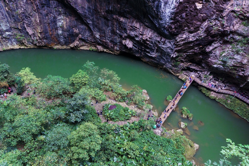
Located in the city of Shaoguan (韶关) in northern Guangdong, Danxiashan is a UNESCO Global Geopark famous for its unique red sandstone landscape, characterized by jagged cliffs, sculpted rock formations, and deep valleys.
With a total area of 290 sq km (112 sq mi), the park offers various hiking trails that showcase spectacular views as well as a scenic boat ride. It hosts an annual hiking race, “Across Danxia” (穿越丹霞), with a 43 km (26.7 mi) course, an 18 km (11.2 mi) course, and shorter family courses.
The park is home to the province’s highest peak, Shikengkong (石坑崆 1,902 m / 6,240 ft), and the second highest peak, Shijiukengding (石韭坑顶 1,888 m/ 6,194 ft). It is on the northern tip of Guangdong, close to the border with Hunan.
The Nanling is a sanctuary for the last stands of ancient forests in Guangdong, with rare plants such as the blue pine. Besides its impressive mountain scenery, Nanling offers hot springs and cascading waterfalls.

Yingxi Fenlin means forest of peaks in the west of Yingde (英德), a city in northern Guangdong. The highlight of this natural wonder is its remarkable karst landscape that features rolling limestone hills draped in lush greenery, crystal clear streams, intricate caves, and bamboo groves.
Apart from hiking, the area abounds in recreational and adventure opportunities such as boat riding, river rafting, cave exploration, rock climbing, hot air ballooning, and paragliding. It is also a cultural attraction with traditional villages, temples, and rice paddies scattered among the peaks.
Major Cities
Several international airports and an extensive high-speed railway network make it easy to travel around Guangdong. The gateway cities are Guangzhou and Shenzhen, though foreign visitors may also base themselves in neighboring Hong Kong or Macau.
Guangzhou (广州)
A sprawling metropolis populated by over 18 million people, this provincial capital has a history spanning over 2,200 years. Its landmarks include the iconic Canton Tower, the Chen Clan Ancestral Hall (陳家祠) and Shamian Island (沙面島).

Guangzhou is renowned for its Cantonese culinary delights, earning a reputation as the "Food Paradise" of China. From street food on pedestrian streets to fine dining at Michelin-star restaurants, it has something for everyone. A must-try experience is yum cha, a Cantonese tradition that involves drinking Chinese tea and eating dim sum dishes.
Shenzhen (深圳)
In the past 40 years, Shenzhen has transformed itself from a fishing village to a hub of technological innovation. Today, this city of 17 million people is nicknamed China's "Silicon Valley."
Shenzhen’s skyline is dominated by futuristic skyscrapers, including the 115-story Ping An International Finance Center (平安国际金融中心), completed in 2017. Visitors can marvel at the breathtaking views from observation decks and chill out at the city's many beaches, golf courses, and theme parks.


Yes. Guangdong has 1,908 named mountains. The highest is Shikengkong at 1,902 m.
The highest mountain in Guangdong is Shikengkong, at 1,902 m.
Guangdong has 1,908 named mountains.


