
Scan the QR code and open PeakVisor on your phone
Guizhou is home to 72 named mountains. The highest is Dahei Mountain at 2,718 m.
Home to dense subtropical forests, deep valleys, and unreal karst formations, Guizhou (贵州, Guìzhōu) has some of the most impressive natural features of any province in China. There are 72 named mountains in Guizhou, the highest of which is Lujiadaying (陆家大营, Lùjiādàyíng) at 2,708 m (8,885 ft) of elevation. The most prominent mountain is Fanjing Shan (梵净山, Fànjìngshān).
Guizhou is a mountainous, rural province in southwestern China. It’s historically one of the most impoverished provinces in the country, although it’s becoming an increasingly popular tourist destination.
Guizhou is bordered by Yunnan province (云南,Yúnnán) to the west, Sichuan (四川, Sìchuān) and Chongqing (重庆, Chóngqìng) to the north, Hunan (湖南, Húnán) to the east, and Guangxi (广西, Guǎngxī) to the south.
While Guizhou is a small province, it’s demographically one of the most diverse in China. Of the roughly 38 million people who live in Guizhou, about 40 percent are from minority ethnic groups, including the Miao, Yao, Bouyei, Dong, Zhuang, Tujia, and Bi groups.
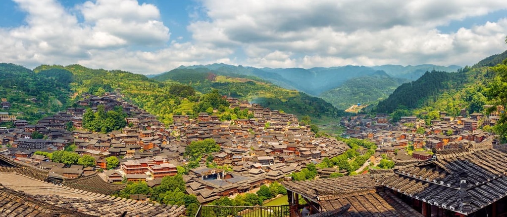
Each of these groups has its own language and cultural practices which differ from mainstream Han Chinese culture, including distinctive architectural styles. Over 50 percent of Guizhou is administered as minority autonomous regions, mostly in the south of the province.
While Guizhou is famous for its historic architecture and traditional villages, there are also several large cities, including the capital Guiyang (贵阳, Guìyáng), as well as Zunyi (遵义, Zūnyì), Anshun (安順, Ānshùn), and Bijie (毕节, Bìjíe), and many smaller county-level cities.
In terms of topography, Guizhou is part of the broader Yunnan-Guizhou Plateau (or Yungui Plateau), which extends through eastern Yunnan and most of Guizhou into Hunan and northern Guangxi.
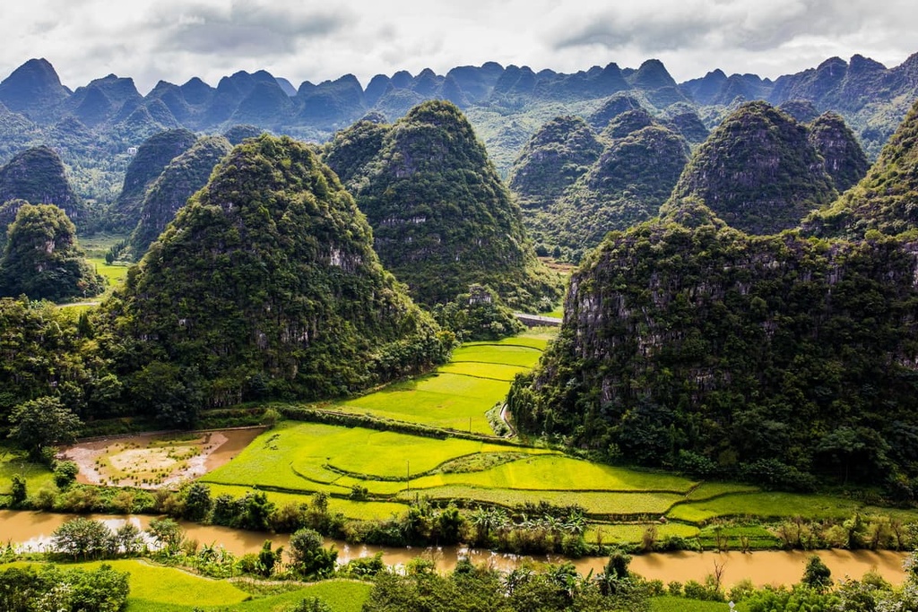
The plateau is characterized by minimal flat land, deep gorges, and steep karst peaks. The tough terrain has historically created challenges for transportation and communication in the area.
Today, Guizhou is home to a number of ambitious engineering projects aiming to modernize the province. These projects include the building of the world’s highest bridge as well as the construction of numerous tunnels through the province’s mountains to allow for the passage of a high-speed railway.
While they’re not the tallest peaks in China, Guizhou’s mountain ranges dominate the province. The mountains of the Yunnan-Guizhou Plateau rise from elevations of about 700 m (2,300 ft) in the southeast of the province to around 2,500 m (8,400 ft) in the west near the border with Yunnan.
The plateau is composed mostly of limestone and basalt, and it’s undergone intense folding, faulting, and stream erosion to produce the dramatic landscapes we see today. Within the plateau, there are two major ranges: the Dalou and the Wuling Mountains.
The Dalou Mountains (大娄山, Dà lóu shān) run about 300 km (190 mi) from Sichuan province through Chongqing municipality (重庆市, Chóngqìng shì) into Guizhou. They form the border between the Yunnan-Guizhou Plateau and the Sichuan Basin to the north.
The Dalou Mountains are composed mostly of limestone peaks between 1,500 to 2,100 m (5,000–7,000 ft), some of which feature tall, dramatic cliffs. The range forms the watershed between the Wu (乌江, Wū Jiāng) and Chishui (赤水河, Chìshuǐ hé) rivers.
The Wuling Mountains stretch from Chongqing municipality through eastern Guizhou into Hunan province. They’re famous for their bizarre, dramatic landforms and rural landscapes.
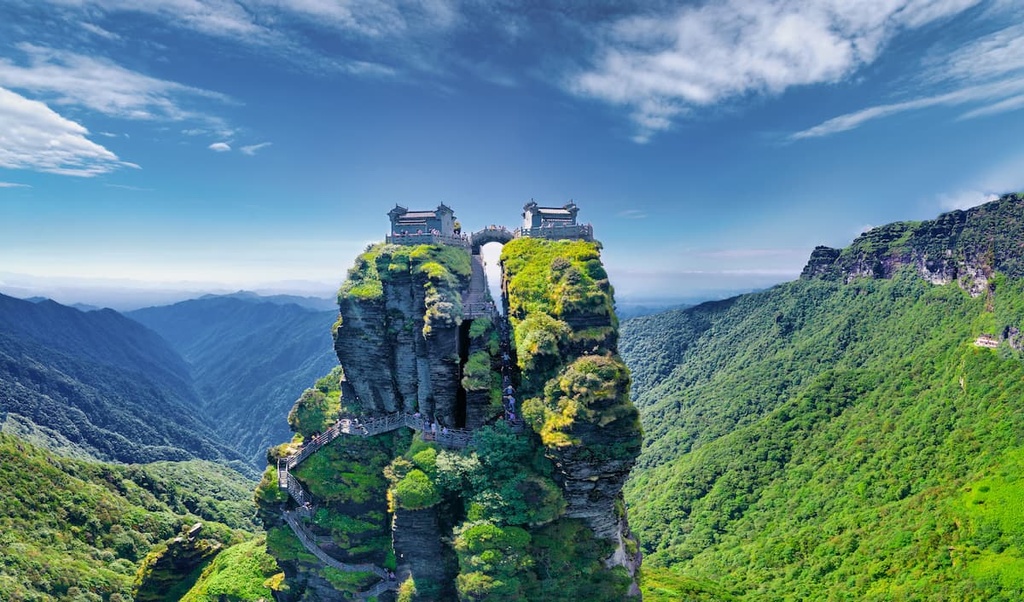
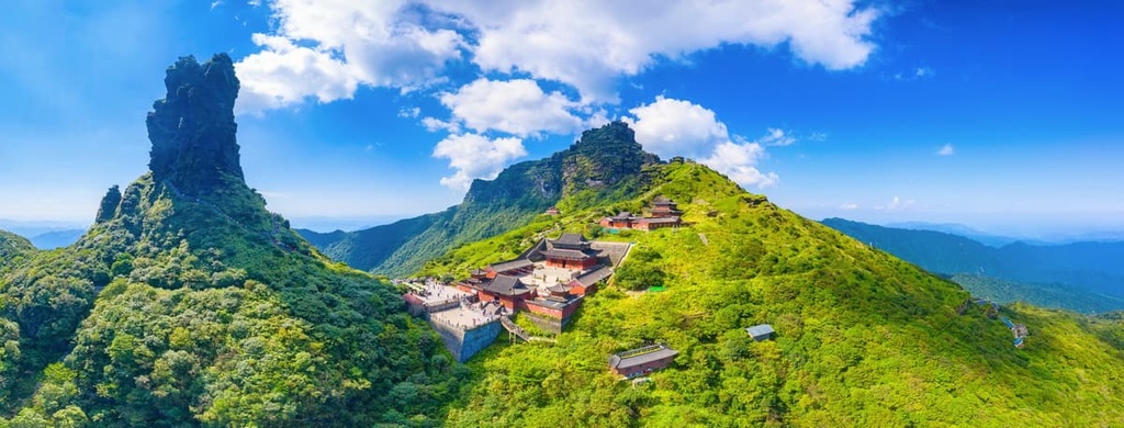
The major mountain destination in the Wuling Range is Fanjing Shan (梵净山, Fànjìngshān), a UNESCO World Heritage Site and the highest mountain in the Wuling Range at 2,494 m (8,182 ft). The mountain is sacred to many Chinese Buddhists.
Guizhou is a warm, subtropical region with diverse plant and animal life. There are over 3,800 species of plants in the province, many of which are important in traditional Chinese medicine.
Because of Guizhou’s isolation and challenging topography, it is home to a number of unique endemic species, including the Fanjingshan fir and the Guizhou snub-nosed monkey, as well as endangered species like Reeves's pheasant and the forest musk deer.
In terms of climate, Guizhou is part of the humid subtropical monsoon area. Winters are cool and wet, while summers can be extremely hot and humid. Fall and spring are the best times to visit Guizhou. Many tourists visit the province in early spring for the rapeseed flower bloom, which fills the countryside with bright yellow flowers.
With its tough, hilly countryside and physical distance from the major population centers in east China, Guizhou has long been one of the least developed provinces in the country.
In fact, a famous saying about Guizhou goes “The sky is not clear three days, the land is not level for three li (a traditional Chinese distance measurement), and the people don’t have three cents.”
As a peripheral province, Guizhou didn’t become part of China’s formal territory until very late in the nation’s 5,000-year history. It was made an official province during the Ming Dynasty in 1413, which led to a flood of migration into Guizhou from neighboring provinces.
During the Qing Dynasty, the Han Chinese Imperial government tried to crack down and impose more authoritarian rule in the province, resulting in a series of major rebellions and revolts by the local minority ethnic groups.
These revolts continued more or less every few decades from the 1700s up to the mid-1900s. The last major conflicts between outside warlords and local ethnic groups (in this case, the Miao people) took place in 1944.
During the mid-twentieth century, Guizhou was also a site for several important events in China’s revolutionary history. The most important of these was the Zunyi Conference in 1935, where Mao Zedong first took control of the Red Army.
Guizhou might not have the tallest mountains in China, but it does have several excellent hiking destinations and lots of stunning scenery. Here are some of the most popular trekking areas in Guizhou.
Once you’ve seen Fanjingshan, you likely won’t forget it. Guizhou’s premier hiking destination is a Buddhist sacred mountain dotted with temples, including two sitting atop a massive rock spire called the Red Cloud Golden Summit.
Fanjingshan reaches an elevation of 2,494 m (8,182 ft) at its highest point on the Old Golden Summit. The two stunning temples on the Red Cloud Golden Summit sit on a subpeak just below the highest point. They’re accessible only by climbing a steep staircase that hangs from the side of a cliff.
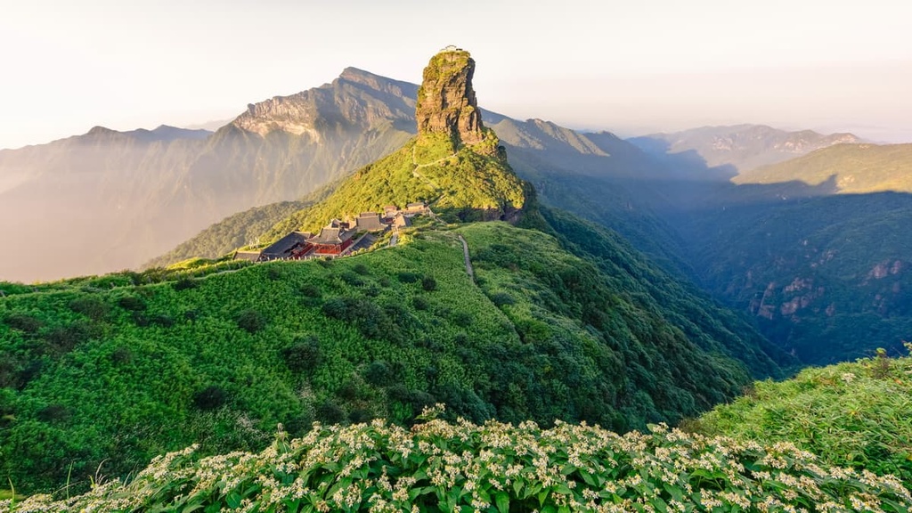
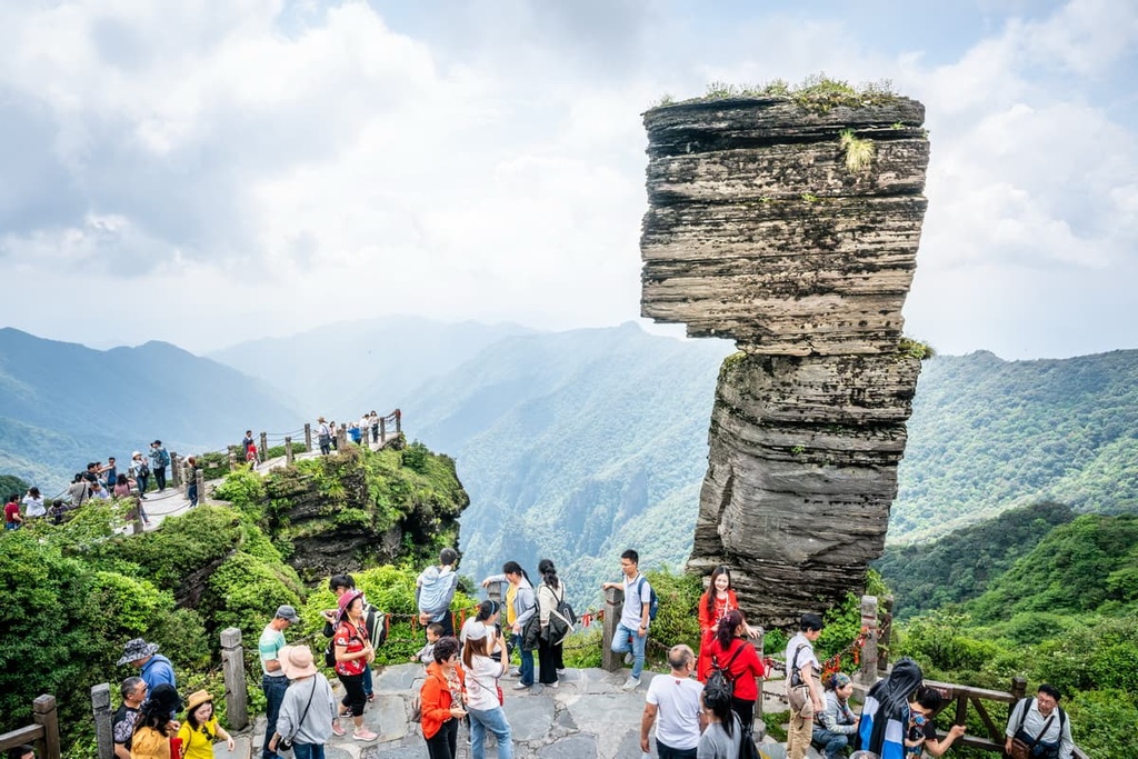
The Red Cloud Golden Summit is one of three summits at Fanjingshan. The third summit, just below the Old Golden Summit, is Mushroom Rock point, which features a large, precariously-balanced rock formation.
In addition to the summits, there are temples and other points of interest scattered throughout the area. While the first temples at Fanjingshan were built during the Tang Dynasty in the late 600s CE, the most active periods for the Buddhist site took place during the Ming and Qing dynasties.
Fanjingshan is considered a Bodhimanda, or a place of enlightenment. It ranks just below the Four Sacred Mountains of Buddhism in China. In addition, Fanjingshan was declared a UNESCO World Heritage site in 2018, both for cultural and natural value. The area is home to the largest primeval birch forest in the subtropics, along with several dozen unique endemic species.
Fanjingshan has been developed as a tourist mountain park, with shuttle buses, a cable car, and shops and restaurants throughout the area. However, it’s still a challenging hike. Even with the cable car, it will take the average hiker about three and a half hours to see all the major sites across the three summits. The hike involves extremely steep stairs and walking near high cliffs.
If you forgo the cable car, expect to spend a total of six to seven hours hiking. There are 6,600 steps on the hiking path between the park entrance and the top of the cable car station. From there, you’ll still have to climb another few thousand steps between the three summits.
The easiest way to reach Fanjingshan is via Tongren (铜仁, Tóngrén), the closest nearby city. Tongren is about 40 km (25 mi) to the southeast of the mountain. You can get to Tongren by airplane or train, then take a passenger bus or taxi to the Fanjingshan Tourist Center. From the tourist center, there are shuttle buses that take visitors to the gates of the park.
The main access point for Fanjingshan is the tourist center at the south gate, but there’s also a west gate, which isn’t served by any bus routes and receives few visitors. There are no cable cars along this route. Hiking Fanjingshan from the west gate takes about six to seven hours.
If you go to Fanjingshan, be aware that it’s forbidden to be on the mountain at night. No one is allowed to begin hiking up after 2 pm and the cable cars stop running at 4 pm. If you’re looking for a place to stay, the nearest town with accommodation is Jiangkou (江口, Jiāngkǒu), just south of the mountain.
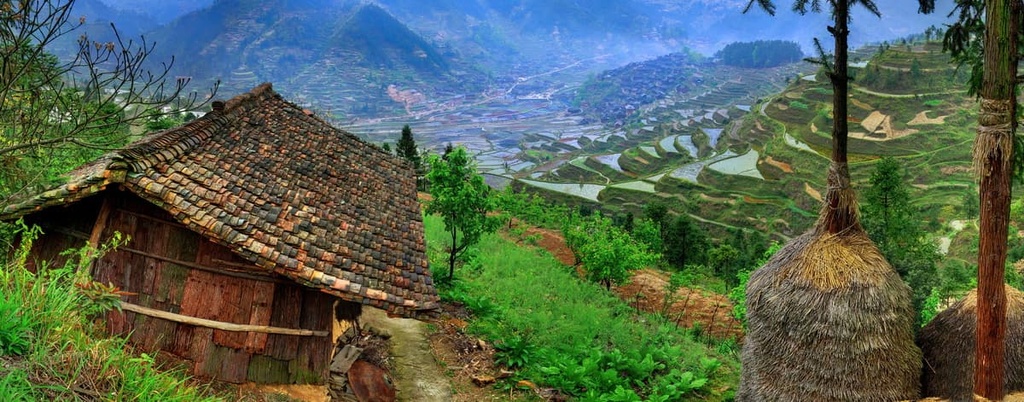
After Fanjingshan, one of the best-known hiking destinations in Guizhou is the Jiabang Rice Terraces (加榜梯田 jiābǎng Tītián). The terraces fill a remote valley dotted with ethnic Miao villages. Visitors can stay in small local hotels and hike the paths between the villages.
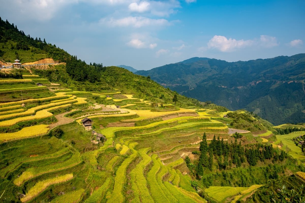
If you visit between April and June, the terraces will be full of water, reflecting the sky above. They turn bright green with rice in the summer and golden in the fall.
The Jiabang Rice terraces are isolated in a hilly part of southern Guizhou and getting there involves a long bus ride. Most people reach the area from Kaili city (凯里, Kǎi lǐ), which is 257 km (160 mi) north of the valley.
Looking for a place to stay in Guizhou Province? Here are some of the best cities and towns in the provinces to check out.
Guiyang (贵阳, Guìyáng) is the capital of Guizhou and a major transportation hub. If you’re coming to the province, you’ll likely pass through Guiyang at some point. The area, which is home to about 4.7 million people, has been inhabited since at least the Spring and Autumn period.
Guizhou is situated in a beautiful natural setting, surrounded by lush green hills. There are a number of interesting historical sites and museums in town, including a provincial museum and a museum of Guizhou’s minority cultures.
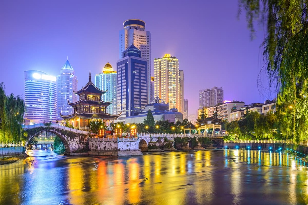
The most visited historical sites are the Jiaxiu Pavilion (甲秀楼; Jiǎxiù Lóu) which was originally built during the Ming dynasty, and the Qingyang Ancient Town, (青岩古镇; Qīyán Gǔzhèn) which is a reconstructed tourist old town that dates to 1378.
One of the most unique sites in the city is the Guiyang North Church, a Catholic church originally built by the French in the late 1800s.
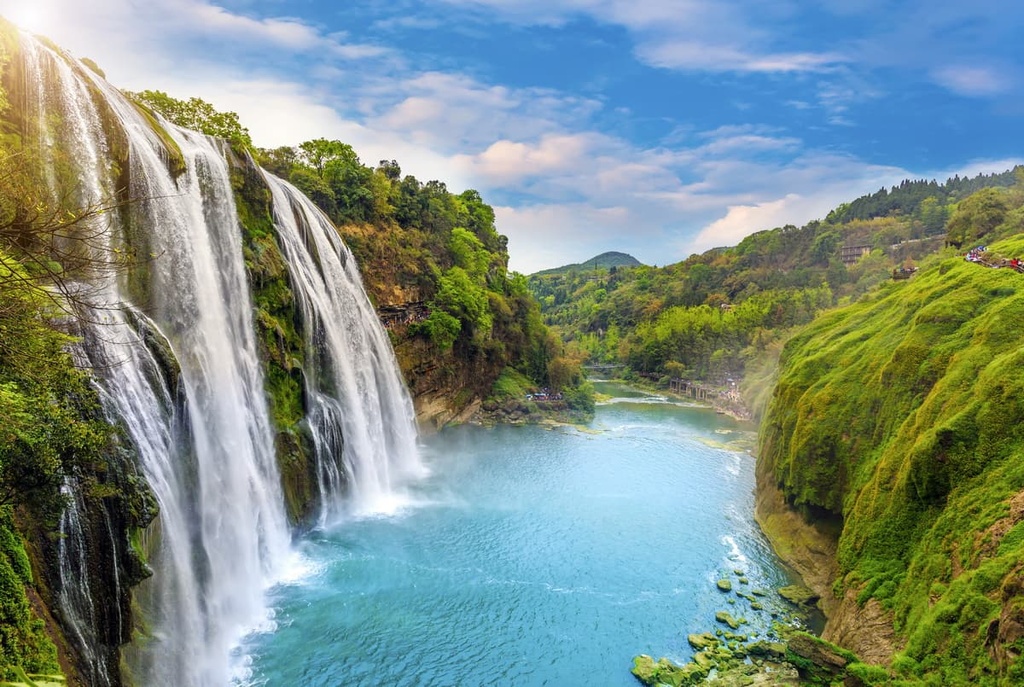
Anshun (安順, Ānshùn) is the other city of note for visitors to Guizhou. The city serves as a gateway to many of the minority areas in southern Guizhou. There are also a handful of natural attractions near Anshun, including the Longgong Cave (龙宫洞, Lónggōng dòng), a massive cave with a river inside of it.
The most notable attraction in the area is the Huangguoshu Waterfall (黄果树瀑布, Huáng Guǒshù Pùbù), one of the largest waterfalls in China. The main waterfall is 67 m (220 ft) high and over 80 m (260 ft) wide.


Yes. Guizhou has 72 named mountains. The highest is Dahei Mountain at 2,718 m.
The highest mountain in Guizhou is Dahei Mountain, at 2,718 m.
Guizhou has 72 named mountains.


