Scan the QR code and open PeakVisor on your phone
Located in west-central Colorado, Eagle County is one of 64 counties in the state. The only east-west interstate highway (I-70) slices its way right across the middle of the county, making it a beneficiary of significant amounts of commerce and tourism. With an estimated 2019 population of just over 55,000, Eagle County is one of the more populous counties west of the Continental Divide, yet its population density is only about 32 souls per square mile. Within a total area of 1692 square miles, the county has 82 named mountains – the highest is Mount of the Holy Cross (the only fourteener in the county) and the most prominent is Castle Peak (not to be confused with the peak of the same name in adjacent Pitkin County). The town of Eagle is the county seat.
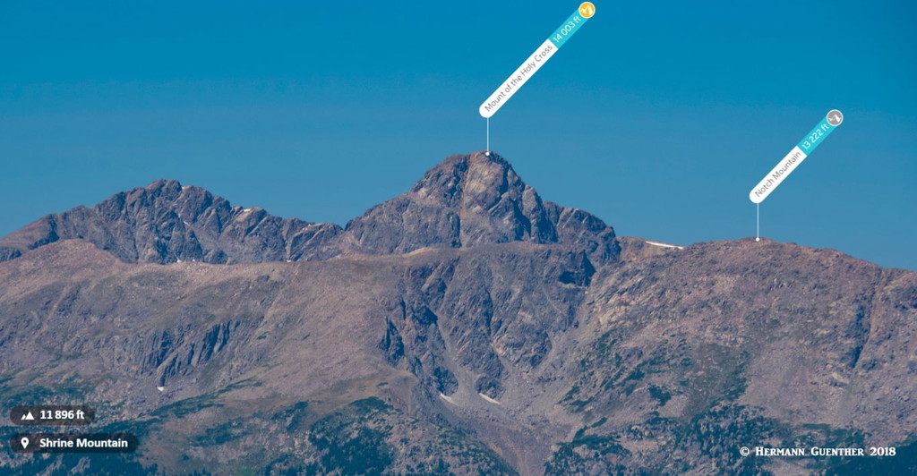
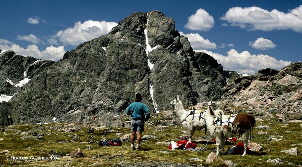
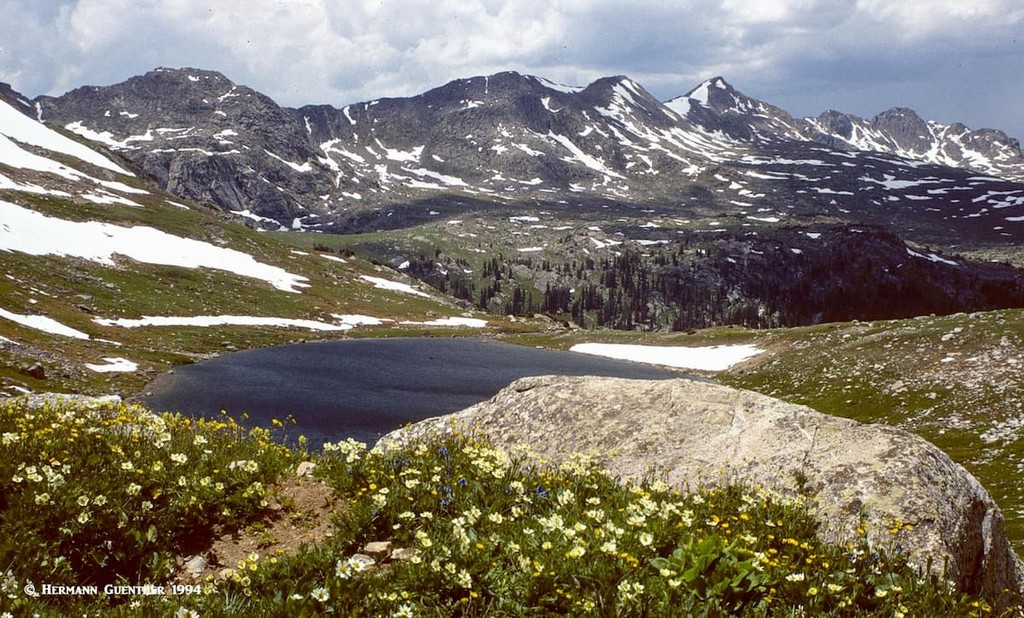
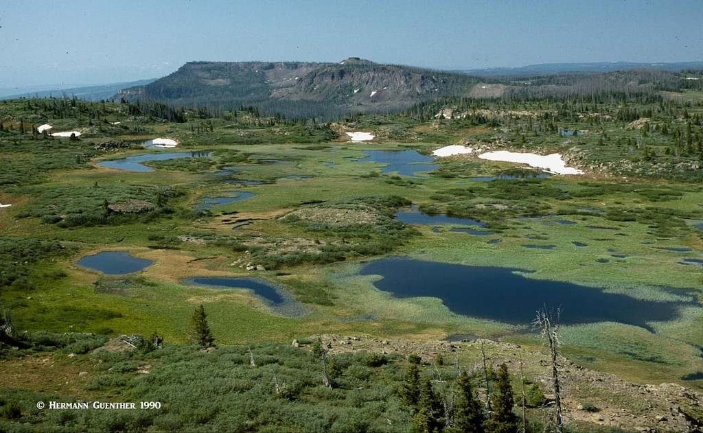
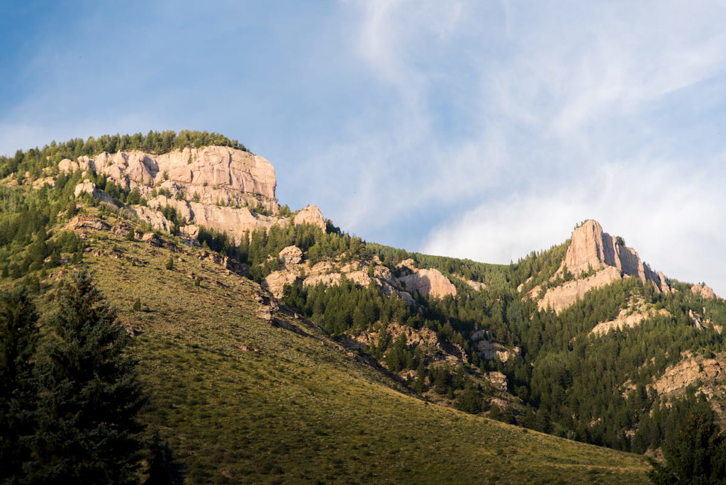
Mount of the Holy Cross, Notch Mountain as seen from Shrine Mountain
Eagle County is named after the Eagle River, which, at only about 60 miles long, is entirely within the county boundaries. It rises at the Continental Divide at Tennessee Pass, which is also on the southern boundary of the county. Adjacent counties include Grand (northeast), Summit (east), Lake (south), Pitkin (southwest), Garfield (west) and Routt (northwest). The county is home to a number of national protected areas including parts of the White River National Forest, the Eagles Nest Wilderness, the Flat Tops Wilderness and the Holy Cross Wilderness. All of these areas afford spectacular hiking opportunities easily accessible from I-70 as well as U.S. Highway 24.
Perhaps the most famous place in the county is the high-end resort of Vail Mountain along with its nearby resort of Beaver Creek. If you want world-class skiing (and can afford it) you need go no further than here. You can even fly there – the Eagle County Regional airport is only 36 miles to the west along I-70, which means you can go from plane to chairlift in about 40 minutes (well, almost). But look around as you drive there – the scenery is sure to astound you. With terrain that is mostly mountainous, you will find almost unlimited opportunities to recreate – whether it is hiking, biking, fishing, kayaking, hunting, camping and many more. No wonder that Eagle County has one of the longest life expectancies of all counties in the United States (only Summit and Pitkin Counties have a longer expectancy). Mountains mean good health - and we support that.
There are fine hiking areas in both the northern as well as southern halves of Eagle County, with I-70 equally dividing the county into these two parts. The best hiking areas in the southern half are centrally located and are mainly concentrated to the west side of US-24, where most of the fantastic Holy Cross Wilderness is to be found. Those in the northern half are concentrated along the county’s eastern boundary in the Gore Range (and Eagles Nest Wilderness) as well as in the northwest corner where you will find part of the Flat Tops Wilderness. While I have only hiked in the Flat Tops a couple of times, all of my experience hiking in Eagle County has been in the Eagles Nest and Holy Cross Wilderness areas, and other non-wilderness locations. And I have hiked and backpacked in these areas frequently, so that much of the following discussion is based entirely on my experience.
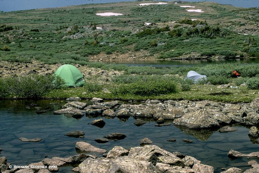
This wilderness is a pristine and beautiful landscape of mountains, lakes, streams and many miles of hiking trails, which makes hiking in this area a supreme pleasure. Though there are plenty of day-hikes that can be comfortably done here, the huge extent of the wilderness makes this a prime area for backpacking with the benefit of making excursions deep into the wilderness more convenient. Let’s start at the north end and work our way southward.
Halfmoon Trailhead - This important trailhead can be found at the end of the eight-mile-long Tigiwon Road (also known as Forest Road 707 and Notch Mountain Road). There are two major trails that start here - the Half Moon Pass Trail and the Fall Creek Trail. The Half Moon Pass Trail is the easiest and most common approach to Mount of the Holy Cross - the only fourteener in the Holy Cross Wilderness and in Eagle County. Even so, it is a very strenuous hike of 12 miles round trip and an accumulated elevation gain of over 5,600 feet (the actual varies slightly depending on which source you believe). Many hikers climb this magnificent peak by backpacking part way in and then climbing the peak the next day.
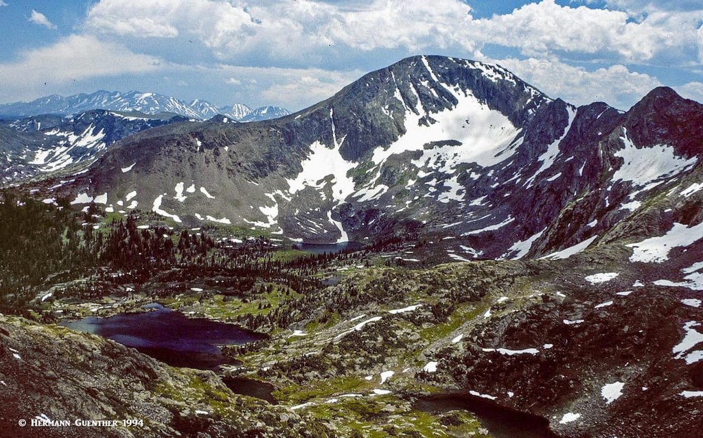
The Fall Creek Trail leads to many fine destinations in its eight-mile one way length. The first is about 2.3 miles from the trail head - the junction from where the trail to Notch Mountain diverts. After negotiating countless switchbacks, Notch Mountain provides a breathtaking view of Mount of the Holy Cross - directly across a narrow cirque. This is the best place to see the entire cross from top to bottom. From Notch Mountain it is possible to continue along an undulating ridge to reach Holy Cross on an alternate route. While that would be an 18-mile round trip hike, it involves less overall elevation gain since Half Moon Pass would not have to be crossed twice. Meanwhile, the Fall Creek Trail continues onward to a number of wonderful alpine lakes including Lake Constantine, the two Tuhare Lakes (via a short spur trail), and the Seven Sisters Lakes, which are reached by going over Fall Creek Pass at 12,150 feet.
Returning the same way would require crossing the pass a second time, although with a car shuttle arrangement, that can be avoided by taking the Holy Cross City Trail back down to the Homestake Reservoir Road. The climb of Whitney Peak (13,274 feet) from the top of Fall Creek Pass is simply delightful and not very crowded. I climbed it without seeing anyone else - on a holiday weekend. Admittedly, that was a few years ago and things are likely to have changed since then.
This ten-mile-long gravel road (Forest Road 704), in combination with the Missouri Creek Road (FR 703), provides access to several major trailheads that serve a number of fine trails that penetrate deep into the Holy Cross Wilderness. This busy road, easily negotiated by regular passenger cars, features two campgrounds as it follows Homestake Creek, along which there are also many fine spots where free dispersed camping is possible. This of course has its disadvantages in that it encourages even more people to free-camp in the great outdoors. More and more such places are disappearing from the Colorado landscape due to overuse and abuse. It remains to be seen if or how long this practice is allowed to continue here.
Whitney Lake Trailhead - Whitney Lake is the only destination served by this trail which is less than three miles one way. For this reason, and for the fact that this trail does not connect to any other maintained trails, it is a lightly trafficked trail. Whitney Peak could be climbed from Whitney Lake, although that would be better accomplished in combination with a backpack trip to one of the many other lakes closer to the interior of the wilderness (see above). Whitney Peak is not often climbed although its gentle northwestern slopes are a delight, and the view from the top is fantastic. Solitude can be virtually assured on its summit.
Holy Cross City Trailhead - This trailhead is right beside the Homestake Reservoir Road just north of the Missouri Lakes Road turnoff. This is actually a jeep trail more than a hiking trail. It goes up to the historic mining town of Holy Cross City, where historic mining camp buildings can still be found. Use of motorized or mechanized vehicles of any kind is prohibitied within wilderness areas. But they are allowed on this trail and in Holy Cross City because both are excluded from the wilderness. There are other hiking trails from that site into the wilderness. Hiking up the jeep trail is not very pleasant when compared to all the other trails in this area.
Missouri Lakes Trailhead - This trailhead provides access to almost unlimited back-country pleasure - once you have hiked here, you will come back again and again, as I have. The beautiful Missouri Lakes basin can be explored on a comfortable day hike involving only eight to nine miles total. The problem is, once you are in the middle of this basin, you don't want to leave. Backpacking is the undisputable solution to that dilemma. You see, there are many other wonderful lakes to explore further afield which will demand much more of your time. Treasure Vault and Blodgett Lake come to mind as do many smaller unnamed ponds and lakes.
Then there are nearby mountains to climb - an enjoyable climb to the top of the prominent 13,127-foot Savage Peak beckons here. It is not as fierce as its name implies, but you will huff and puff your way up its northeast ridge - and then comes the even steeper summit cone! This mountain is more admired than climbed. If you only have time for a day hike and want an alternative to the out-and-back trek to Missouri Lakes, it is still possible to see them all (though one is kind of off the trail a bit) and then head over Missouri Pass, down to Treasure Vault Lake, and then return back to the trailhead via Fancy Pass and Fancy Lake. This nine-mile loop hike is very popular, but does involve considerably more elevation gain than merely going to the Missouri Lakes and back.
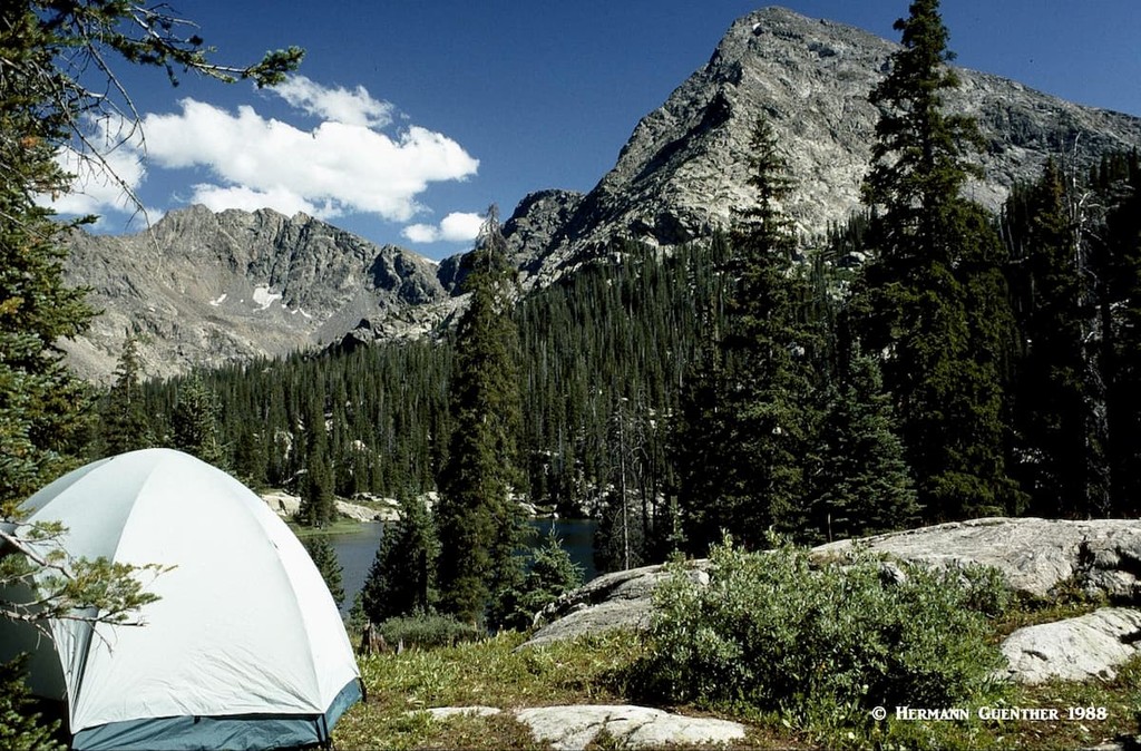
On the north side of I-70, right within the town limits of Vail, are several stunning hikes that can be made into the rugged Eagles Nest Wilderness, and they can all be made from three trailheads that are just off the highway. While the mountains in this lovely part of the Gore Range are not frequently climbed (though they do offer some of the finest ridge-walking in Colorado), the deep valleys leading out of these peaks have some alpine lakes at their heads that are among the most pristine gems to be found in Colorado. They make excellent destinations for day hikes, though getting to them can be quite strenuous as the trails are long, steep and involve considerable elevation gain. I have been to all of these lakes – several times to each one.
Gore Creek Trailhead - At the eastern end of the Vail Valley, just at the base of Vail Pass, is the Gore Creek Campground and directly adjacent is the parking area for the Gore Creek Trail. Unlike the other trails emanating from the valley, this trail provides through access to the eastern sections of the Gore Range, where the trail climbs over Red Buffalo Pass (elev. 11,742 feet) and then joins the Gore Range Trail (what else?). About five miles up the Gore Creek Valley is a two-mile spur trail that ends at the beautiful Gore Lake. To do that as a day hike involves a round trip of about 14 miles and almost 3,000 feet of elevation gain. It is worth the effort. Also starting at this same trailhead is the trail to Deluge Lake - a shorter round trip length of 9 miles, but an elevation gain of close to 3,500 feet. Also to be recommended.
Pitkin Creek Trailhead - Easily accessible from the East Vail interchange on I-70, the Pitkin Creek Trail does not pamper the hiker. Right from the start, it is steep, and although it has some flatter segments, relief is infrequent and a total accumulated elevation gain of 3,500 feet (net elevation difference of 3,000 feet) in a round-trip distance of eleven miles is sure to generate a thirst for a cold beer at the end of the hike. But the lake itself is an alpine gem. And for those who think that they need more of a workout, the surrounding high terrain is sure to satisfy that urge. This is without a doubt one of the finest hikes in the Gore Range in my humble opinion. Not to be missed by anyone in reasonably fit condition. It is also advisable to bring a fishing rod - the trout in this lake are fat and hungry.
Booth Creek Trailhead - Also accessible from the East Vail interchange is the Booth Creek Trailhead. Parking at the trailhead is very limited, so an early start is advisable. It is best to park in the Vail Village parking structure and then take the free Town of Vail bus to access this trail. The trail to Booth Lake, just like the Pitkin Lake Trail, is strenuous. With a round-trip hike of almost 11 miles and an elevation gain of over 3,000 feet, this wonderful hike is another one in the Vail area that is a must-do venture. For those with an extra reserve of energy, there are many opportunities to scramble to higher perches above the lake and to view its spectacular setting in this high-alpine cirque. The lake has an island - and many fish. It is possible to combine this hike with Pitkin Lake, but that would involve some major scrambling and a lot more elevation gain, not to mention the need for a car shuttle. There is no designated trail by which to do this.
Shrine Mountain Trailhead – My wife and I discovered the wonderful hike from this trailhead only about four years ago. We have done it every year since then. About two miles from the I-70 interchange at the top of Vail Pass, along the Shrine Pass Road, is an obvious parking area. This is where the trail to Shrine Mountain and the long and gentle Wingle Ridge begins. The top of Shine Mountain has some very interesting rock formations. But the main reason we come here is for the exceptional views in all directions encompassing the Holy Cross Mountains, the Tenmile Range and the Gore Range. At the right time of summer, the wildflower displays just below the summit are second to none.
This short six-mile round trip hike involves only 1,300 feet of elevation gain – consequently, it has become quite popular. At the point where the trail first emerges on top of the ridge, most hikers will go to the right (north) for the summit of Shrine Mountain. But an alternative is to go left and follow the Wingle Ridge south for however far you want to go, even all the way to Ptarmigan Hill (12,146 feet). Since this is at almost 12,000 feet, you are exposed up here and want to be sure to watch the weather. The views from this trail are nothing less than stunning.
Totally unlike any other wilderness area in Colorado, the Flat Tops Wilderness offers an environment and ecological landscape so different that one might think this is not even in the state. This place has countless lakes, ponds and tarns, most of them nameless, plus at least 100 miles of streams. To suggest that this means it is an angler’s paradise would be an understatement – this is an area of amazing trout habitat. With all that water, you will have millions of mosquitoes to share your experience. The trout love them and the mosquitoes love us. So come prepared.
I mentioned earlier that Eagle County includes parts of three wilderness areas, including the Flat Tops Wilderness. That is quite correct, but I want to make clear that the part of this wilderness that is actually within county boundaries is so small as to be almost totally insignificant as compared to the immense size of the Flat Tops – 235,035 acres or 367 square miles. At most, five square miles of this huge area is in Eagle County. There are two trailheads just barely within the county; they are not hiking trails but access points for off-road or 4WD vehicles. I know, I have driven one of them to its end at the wilderness boundary, from where I hiked up onto the plateau on a rarely-used trail for a three-day outing. We saw no other hikers for the entire time, but I certainly got to experience this unique landscape.
Because this wilderness is mostly in other counties, I will not discuss Flat Tops trails here and instead refer you to this article. Near the end of that article, you will learn a bit more about this magnificent wilderness area. Also, a dedicated article for the Flat Tops Wilderness Area is forthcoming. So please stay tuned.
Much of the population of Eagle County lives along the I-70 highway corridor where the major towns are located, extending from Vail in the east to Dotsero in the west. Some of these are really small and offer almost no tourist amenities, including Wolcott and Dotsero. Others, such as Eagle-Vail, Avon, Edwards and Gypsum, are functionally extensions of either Vail or Eagle, the county seat. But they do offer accommodations, restaurants and shopping. Gypsum is also home to the Eagle County Regional Airport, which offers scheduled non-stop airline service from major cities across the United States, with most service happening during the ski season. It is really cool to see a large jetliner making its final approach right over I-70 – a sight a newcomer to the valley might not expect to see in a mountain environment.
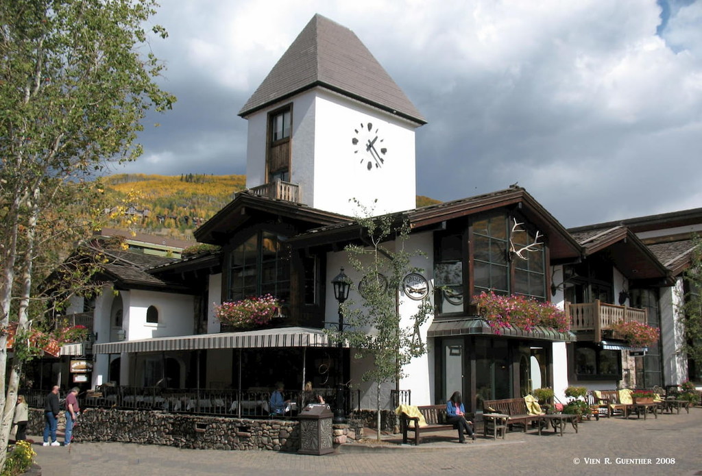
Everyone with an interest in skiing (or not) has heard of the swank resort of Vail in the central Colorado Rockies. With a population of 5,434 (2019 estimate), it offers everything a visitor could ask for and at prices that are, well, not for everyone, especially during the ski season. Budget accommodations are rare in this resort that was modeled after high-end resorts in the Alps. But Vail is more than a ski resort. It offers a wide variety of recreational activities including biking, fishing, golf, rafting, high-adrenaline activities, and more and more. But Vail also has some of the finest hiking trails in the state right at its doorstep. Some of the best trails into the Eagles Nest Wilderness start right off the highway, and within minutes, the hiker is in a pristine wilderness area. This place has a prime location and it is well visited. And those who cannot justify or afford staying here, they can still enjoy strolling the quaint streets of Vail Village and stopping for a nice meal in one of the many restaurants. One of our favorite hikes starts just a short distance east of Vail, on the Shrine Pass Road which leaves I-70 at the summit of Vail Pass. The views from the top of Shrine Mountain are some of the finest in Eagle County.
Positioned conveniently right on I-70 halfway between Vail and Glenwood Springs, Eagle is a burgeoning town that has grown from a population of 3,032 in 2000 to 6,508 in 2010. The estimated population as of 2019 was just shy of 7,000. By highway it is just over two hours from Denver and about five minutes from the Eagle County Regional Airport. It is a convenient base for exploring the northernmost part of the Holy Cross Wilderness - specifically the Lake Charles Trailhead. But the fine hiking trails in the southwestern part of the Eagle Nest Wilderness (see above) are only about 30 miles away in Vail. This town offers reasonably priced accommodations and eating establishments. The nearby Sylvan Lake State Park is a notable attraction in Eagle. The town is located at the confluence of Brush Creek and the Eagle River. The world-famous hot springs at Glenwood Springs are only a 30-minute drive away.
Minturn is one of the few towns in Eagle County that is not located directly on I-70, though it is just a few miles to the south on US-24, nestled below impressive cliffs just, one of which is called the Lionshead. What was at one time nothing much more than "a wide spot in the road" has become a charming and fashionable alternative to the big resorts dotting the Colorado landscape. Minturn is well positioned to serve as a base from which to explore the northern part of the wonderful Holy Cross Wilderness. This town is especially handy to the trails starting at the upper end of the Tigiwon Road. The wonderful hiking trails of the Vail Valley are just minutes away. With a population of little more than 1,000 inhabitants, this charming town does have a limited supply of accommodations and eating establishments, but it may be just what some people want in terms of a cozy and quiet place on the banks of the Eagle River to spend a few nights.
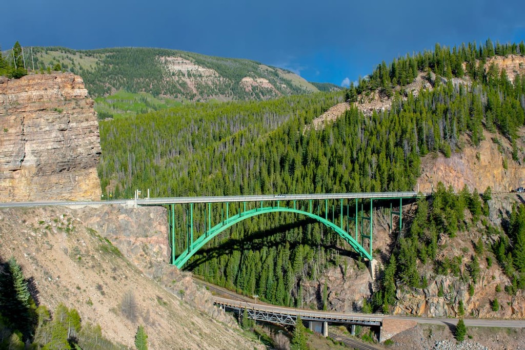
This tiny town (also sometimes referred to as Redcliff) with a population of less than 300 residents is conveniently positioned at the western end of the Shrine Pass Road where it meets US-24 about ten miles south of Minturn. This isn’t so much a place to stay as it is to see, since it is a former mining camp situated in the canyon of the upper Eagle River. It is tucked away almost directly behind the historic steel arch bridge that carries U.S. Highway 24 across the river. The first community to be established in the Eagle Valley, Red Cliff served temporarily (from 1883 to 1921) as the seat of Eagle County. This town is not much more than a collection of older homes, but a recent revival has resulted in some new businesses, including a restaurant and an inn housed in one of the older buildings. The town serves as a popular access point to Shrine Pass for cross-country skiing, snowshoeing and snowmobiling. The popular Shrine Mountain Trailhead is but a few miles up the road to Shrine Pass, which is not open for cars in winter.