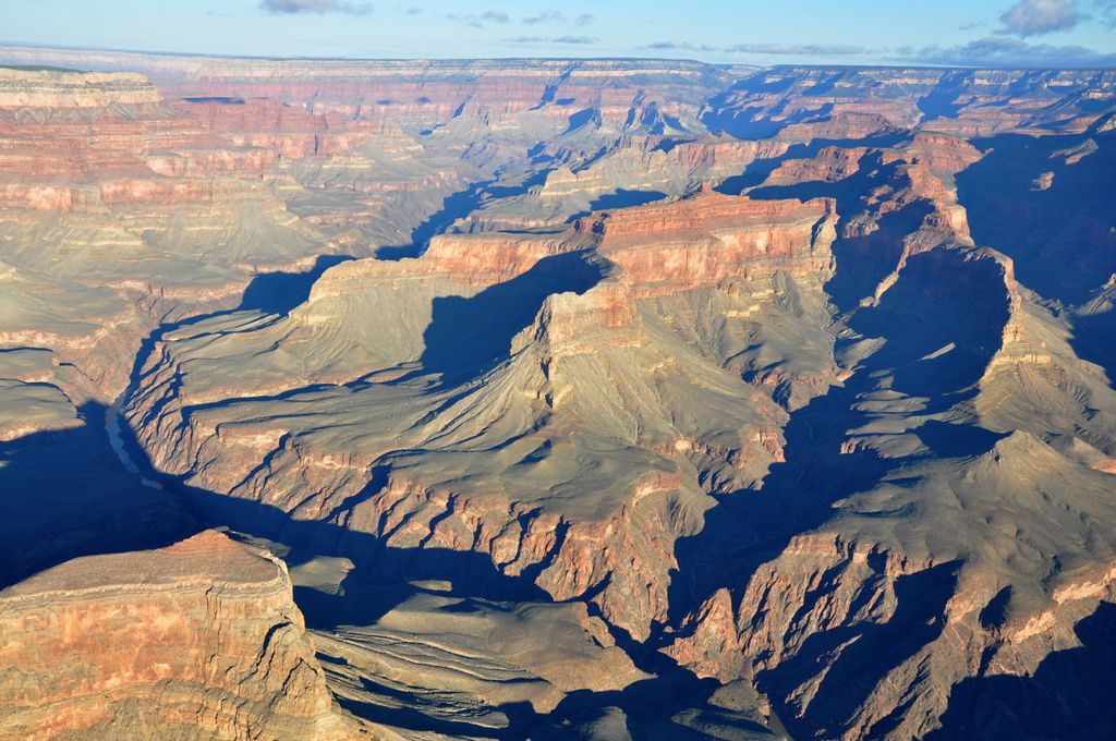
Scorpion Ridge is a 5,832-foot (1,778 m) prominence, and a ridgeline-landform shaped like a scorpion, composed of the colorful red-orange Supai Group rocks, a linear ridge with two south-projecting arms of ridgeline that trend south to the Colorado River. Scorpion Ridge is approximately 11 miles (18 km) northwest of Grand Canyon Village near the beginning of West Grand Canyon. The Scorpion Ridge-Sagittarius Ridge north–south ridges are adjacent west to the North Rim ridgeline that extends south to Imperial Point, overlooking the beginning of West Grand Canyon. The position of Scorpion Ridge causes the Colorado River to flow west, then northwest, then north. Surrounding the two ridgelines to the Colorado, the river has the Serpentine Rapids west, the Sapphire Rapids (the drainage between the two scorpion-arms), and the Willie Necktie Rapids, just downstream from Tuna Creek confluence, and Canyon, the major drainage at the east of the Imperial Point ridge.
The Scorpion Ridge (body and arms) trend north-northeast for 2.5 miles (4.0 km); both arms are roughly 1.0 mile (1.6 km) long, with the trendline, and curved inward like enclosing arms. The high point of Scorpion Ridge (5,832 ft) is near the center of the north trend (composed of a remainder cliff-spire of Esplanade Sandstone on Wescogame Formation on platform-ridgeline of Manakacha Formation); the east arm height ends at 4,961 feet (1,512 m); the west arm ends at 4,594 feet (1,400 m). On the Colorado, Scorpion Ridge is opposite Geikie Peak, Pollux Temple, Serpentine Canyon outfall, west, and Sapphire Canyon outfall, east.
By prominence Scorpion Ridge is
# 51 out of 280 in Grand Canyon National Park # 39 out of 203 in the Kaibab Plateau
We use GPS information embedded into the photo when it is available.
3D mountains overlay
Adjust mountain panorama to perfectly match your photos because recorded by camera photo position might be imprecise.
Move tool
Rotate tool
Zoom
More customization
Choose which peak labels should make into the final photo and what photo title should be.
Next
Photo Location
Satellitte
Flat map
Relief map
Latitude
Longitude
Altitude
OR
Latitude
°'''
Longitude
°'''
Apply
Register Peak
Peak Name
Latitude
Longitude
Altitude
Register
Teleport
PeakVisor
This 3D model of Sagarmatha National Park in Nepal was made using the PeakVisor app topographic data. The mobile app features higher precision models worldwide, more topographic details, and works offline. Download PeakVisor maps today.
Download OBJ model
PeakVisor
The download should start shortly. If you find it useful please consider supporting the PeakVisor app.
PeakVisor for iOS and Android
Be a superhero of outdoor navigation with state-of-the-art 3D maps and mountain identification in the palm of your hand!