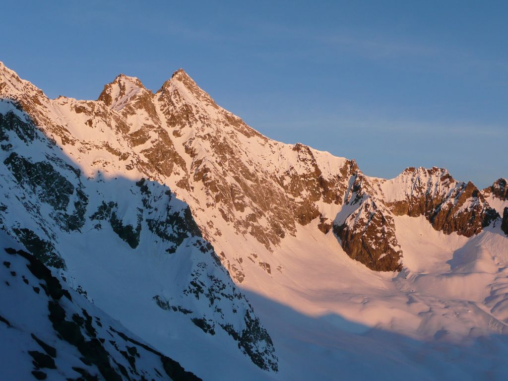
Pic de Neige Cordier is a mountain in the Massif des Écrins range, located in the Hautes-Alpes département of France. The mountain is named after the French alpinist Henri Cordier. It has an elevation of 3614 meters and is a fine mountain located in the Dauphiné Alps and belongs to the Écrins massif. It’s a superb viewpoint situated at the apex of Glacier Blanc. The south side of the mountain descends into Glacier Blanc, while the northeast side descends into Glacier d’Arsine.
The first ascent of Pic de Neige Cordier was made on 3 August 1877 by French climber Paul Guillemi along with Émile Pic and Pierre Estienne.
Pic de Neige Cordier is located in the Écrins National Park, which is a French national park located in southeastern France. It is named after the massif of the same name located within its boundaries. The park covers an area of 918 square kilometers and ranges from 800 to 4,102 meters in elevation.
The nearest ski resorts to Pic de Neige Cordier are Serre Chevalier and Les Deux Alpes.
Serre Chevalier is renowned for its vast ski area that reaches over 2,800 meters in altitude. It offers an exceptional setting for winter sports. The resort has phenomenal tree skiing too and is famed for its off-piste. Snow cover is exceptionally good due to the resort’s north-facing position. Slopes are colder for longer and tend to hold onto more snow. The resort offers 250 kilometers of slopes spread across 410 hectares of marked trails.
Les Deux Alpes is one of the best ski destinations in France. It offers a wide range of slopes for all levels of skiers and snowboarders. The resort has a glacier that allows skiing even in summer. The resort also has a snow park with a half-pipe and boardercross course.
The nearest mountain hut is Refuge des Écrins located 1 100m/3 610ft SW of the summit.
By elevation Pic de Neige Cordier is
# 52 out of 500 in Parc national des Écrins (cœur) # 51 out of 2176 in Hautes-Alpes # 51 out of 6312 in Provence-Alpes-Côte d'Azur # 52 out of 1609 in the Dauphiné Alps
By prominence Pic de Neige Cordier is
# 97 out of 500 in Parc national des Écrins (cœur)
We use GPS information embedded into the photo when it is available.
3D mountains overlay
Adjust mountain panorama to perfectly match your photos because recorded by camera photo position might be imprecise.
Move tool
Rotate tool
Zoom
More customization
Choose which peak labels should make into the final photo and what photo title should be.
Next
Photo Location
Satellitte
Flat map
Relief map
Latitude
Longitude
Altitude
OR
Latitude
°'''
Longitude
°'''
Apply
Register Peak
Peak Name
Latitude
Longitude
Altitude
Register
Teleport
PeakVisor
This 3D model of Sagarmatha National Park in Nepal was made using the PeakVisor app topographic data. The mobile app features higher precision models worldwide, more topographic details, and works offline. Download PeakVisor maps today.
Download OBJ model
PeakVisor
The download should start shortly. If you find it useful please consider supporting the PeakVisor app.
PeakVisor for iOS and Android
Be a superhero of outdoor navigation with state-of-the-art 3D maps and mountain identification in the palm of your hand!