
Scan the QR code and open PeakVisor on your phone
There are 255 named mountains in Ecrins National Park (or Parc national des Écrins (cœur) as it goes poetically in French). The highest and the most prominent mountain is Barre des Écrins (4.102m).
The Écrins National Park is one of France’s ten national parks and was created on the 27th March, 1973. It is located in south-eastern France in the Dauphiné Alps south of Grenoble and north of Gap; the park is shared between the departments of Isère and Hautes-Alpes. The park covers an area of 918 km2, with high peaks, glacier fields, valleys, alpine pastures, subalpine woodlands and lakes. There are over 2,500 species of flora and 350 endemic species of fauna.
Music Project Mountain by Kristian Skybound (c) copyright 2018.
The highest and the most prominent mountain in the region is Barre des Écrins standing tall at 4,102m. It is the most southern alpine peak in Europe that is higher than 4,000m, and it is the only mountain higher than 4,000m in France that is not part of the Mont Blanc Massif. Before the annexation of Savoy in 1860, it used to be the highest mountain in France.
The mountain is surrounded by four glaciers: to the north-west, is the Bonne Pierre glacier, to the north-east is the Glacier Blanc, to the south-west is the Glacier du Vallon de la Pilatte, and finally in the south-east there is the Glacier Noir. It is separated from Snow Dome of Écrins (4,015m) by Lory Gap (3,974m) to the west, Barre Noir (3,751m) by Écrins Gap (3,661m) to the north-east and by le Fifre (3,699m) via the Col des Avalanches (3,499m) to the south.
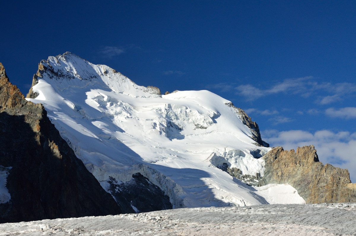
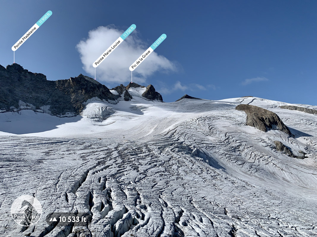
According to some scientific research concerning the topography of the region, the height of the mountains in the Écrins National Park and the Dauphiné region have been changing due to the erosion caused by small glaciers, such as the Glacier de Mont-de-Lans (the largest skiable glacier in Europe) on the slopes of the Pic de la Grave and the Glacier de Freydane in the Belledonne range. This topographic effect is called the glacial buzzsaw.
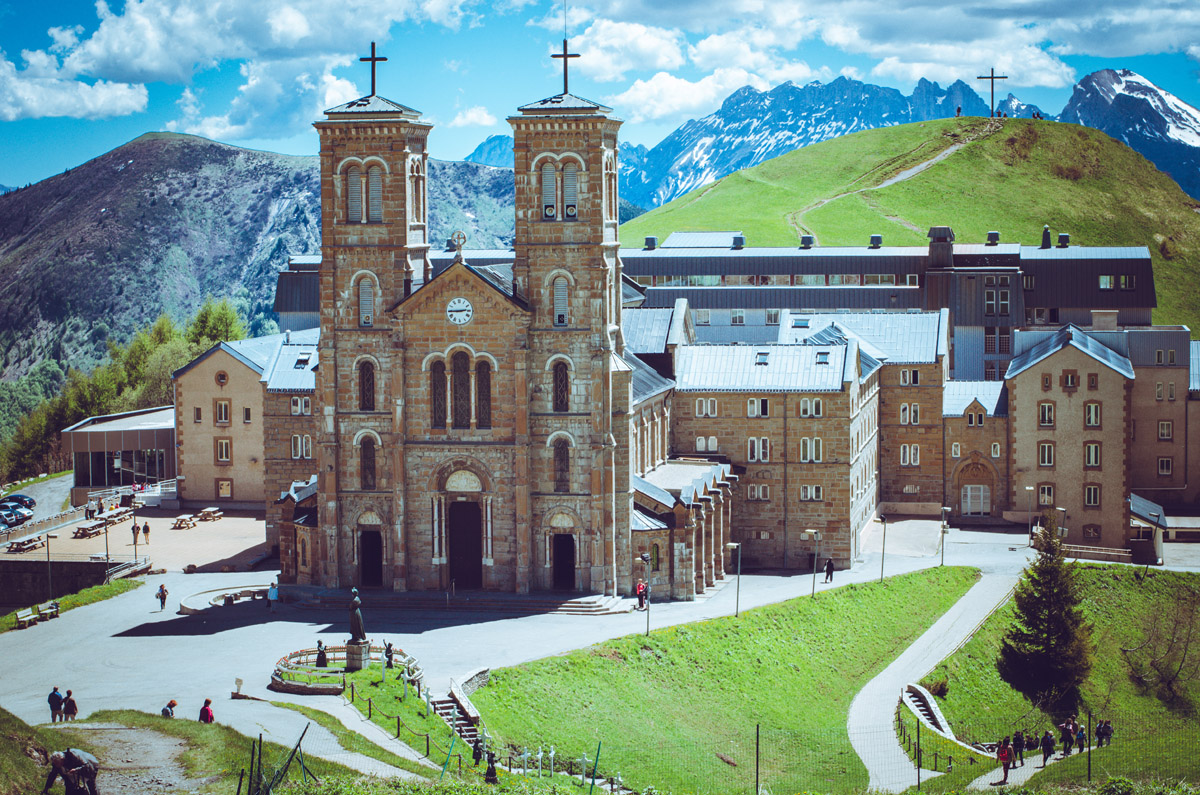
The sanctuary of Notre Dame de la Salette is located in the mountains (1,800m) above the village of La Salette-Fallavaux. It is a well-known pilgrimage site devoted to an 1846 Marian apparition. It is colloquially known as the Lourdes of the Alps. The impressive basilica is certainly worth a visit and has the equally impressive Écrins national park as its background.
Barre des Écrins is the subject of the longest photographed and recognised line of site on Earth. In July 2016, Marc Bret took a photograph of the Écrins from Pic de Finestrelles in the Pyrenees, a distance of 443km away. Bret used a Panasonic Lumix FZ72 with a 1200mm zoom lens.
The Ecrins National Park can be divided into seven big areas:
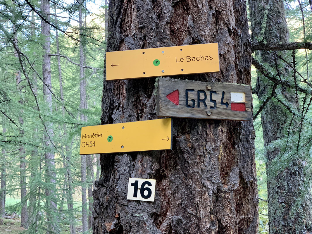
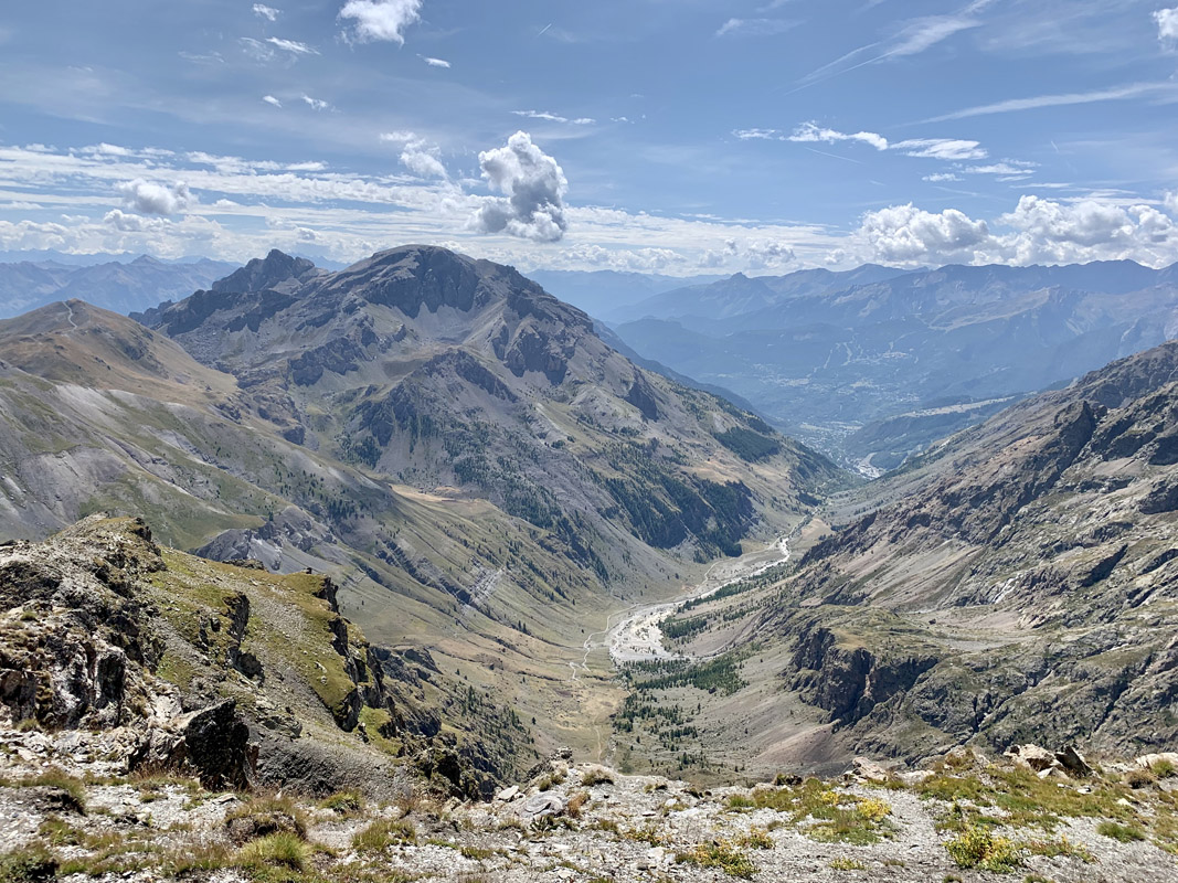
GR54 also known as the grand randonnée of the Écrins is at the heart of the national park. This is a great hike to do either in its entirety or in parts. The route follows the footsteps of mountaineering pioneers. The peaks of la Meije (3,983m) and Barre des Écrins (4,102m) are a sight to behold.
GR54 is the most mountainous grand randonnée of the Alps, yet it remains accessible to less experienced hikers. GR54 is peppered with several technically difficult sections. The scenery varies from alpine valleys to majestic high mountain passes. The whole route would take 10-15 days to cover completely, but you could always just choose the best bits for one-day hikes. Whatever you decide to do, the Écrins national park will certainly leave its mark and you will be eager to return!
GR54 is part of a trilogy of hiking trails in the French Alps (with Mont Blanc and the Vanoise national park being the other two). It is arguably the wildest of them all and the most difficult as a result. It spans 184km, 14 mountain passes and more than 12,800 vertical meters of elevation. There is a choice of two starting locations: Bourg d’Oisans and Argentière-la-Bessée.
Should you opt to start from Bourg d’Oisans, be ready for arduous climbs that begin with handrails to climb the small hamlets clinging onto the steep mountainside. The impressive nature of this route will lure even the most fastidious hiker to follow in the footsteps of the pioneers of the Écrins. It allows you to discover the most remote alpine pastures, high glacial lakes and waterfalls of the River Onde.
If you start from Argentière-la-Besséem this version is 2 days longer than that from Bourg d’Oisans. This itinerary starts gently alongside the waterfalls of the river Onde up to the foothills of the mountain pass of La Pusterle. It joins GR54 from Bourg d’Oisans, by the Col de la Cavale. On the return leg, the routes separate once more at the Vallouise.
The best time of the year to attempt this route is between June and mid-September. It will be less busy towards the end of the season, whereas the weather will still be pleasing and soothing to do a decent hike - September heat can easily extend into October. You will need to be aware of the changeable weather conditions of the high mountains, and snow conditions as well, therefore, check the weather forecasts for the area you are going to endeavour on a regular basis. Snow lies all year round on the highest peaks of the Écrins and may require the use of special equipment or apparel.
GR54 traverses Vallon de Chambran. The view of the valley from the summit of Rocher de l’Yret.
Barre des Écrins offers one of the biggest challenges in the Écrins national park and with that one of the best views across the vastness of the area. The snow is permanent here all year around and you will need some appropriate gear. The high altitude also poses quite a challenge that you will have to adapt to.
Starting in the parking area of Chalet Refuge du Pré de Madame Carle at the end of the Saint-Pierre Valley. Following signs to the Refuge des Écrins (8km from the start), you will reach the Glacier Blanc after about two hours of hiking. Continuing alongside the glacier, the path to the summit offers splendid views of Mont Pelvoux (3,946m) ahead.
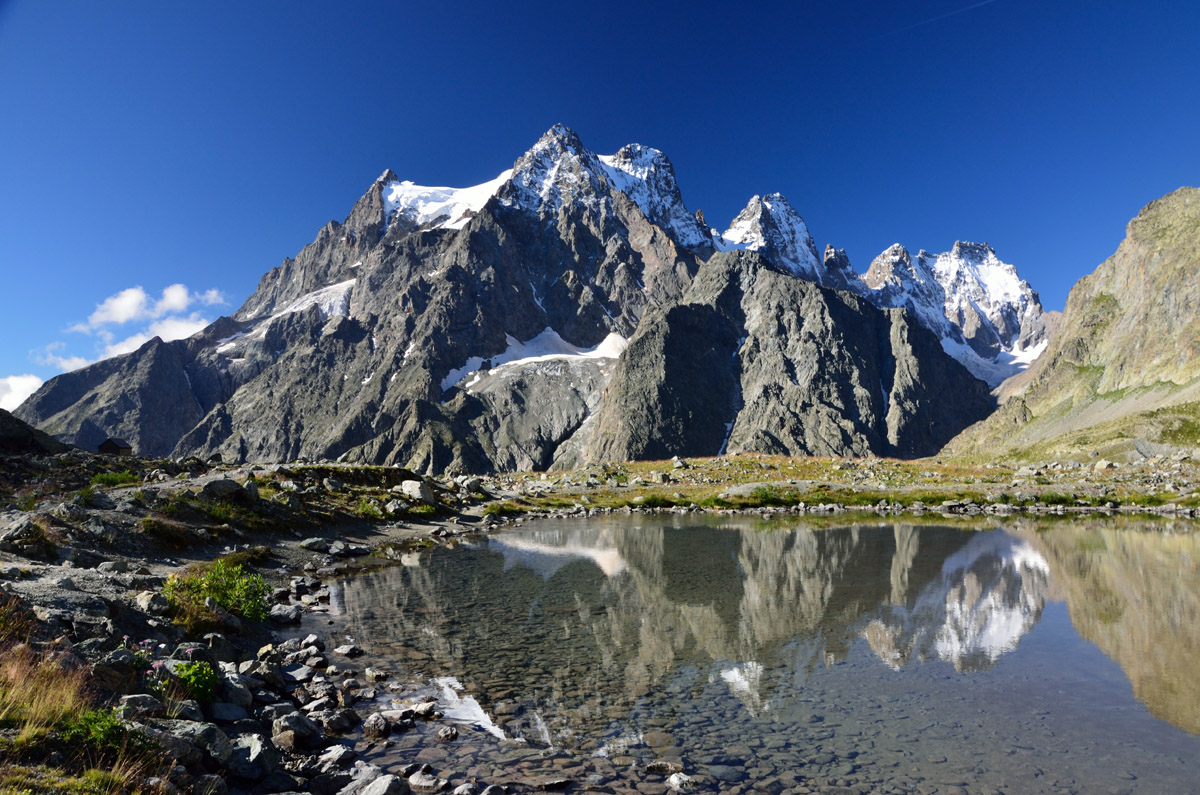
Once you have arrived at the Refuge des Écrins, you have a number of options. You can turn back, continue on or stay in the refuge overnight before deciding (you will have to book in advance, especially during peak months). If you decide to continue to the summit you will need some serious climbing gear as the route becomes more and more vertical. At the summit of 4,102m, there are genuinely breathtaking views across the whole of the Écrins national park and beyond.
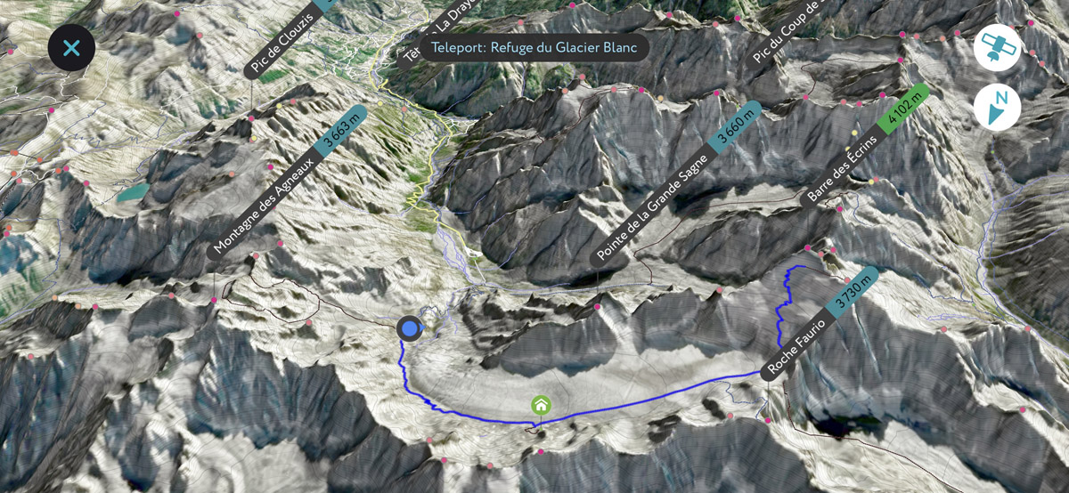
If you were to complete the entire hike in one go, you would need 2 days to do so, with a night at the Refuge des Écrins recommended. At 24km in length and with 2,037m of elevation gain, this is a hike reserved for experienced mountaineers looking for a challenge.
Whilst not being the highest point of the Écrins, La Blanche is virtually an unmissable hike allowing you to admire the Écrins in all their splendor. It provides the best opportunity to observe the high peaks of Barre des Écrins, les Cerces and Pic sans Nom. Starting from Puy Aillaud, this 13.67km loop with 1,479m of vertical elevation is recommended for experienced hikers. (estimated time is 7h35)
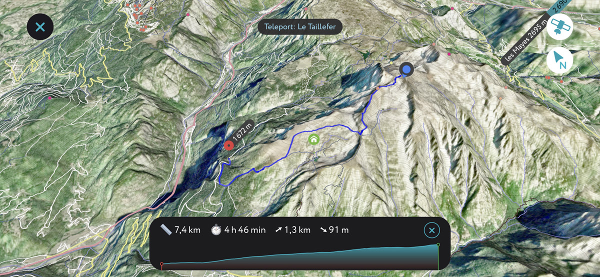
Le Taillefer is located on the northern boundary of the national park, there is a hike which includes the ascensions of Petit and Grand Taillefer, the first summits of the Belledonne mountain range, perfectly visible from the city of Grenoble. The vantage point from the summit provides a magnificent view of Mont Blanc, the summits of the Écrins Massif to the south, the Vercors High Plateaus Natural Reserve to the east and le Dévoluy to the west. At 12.87km in length with 1,304m of vertical elevation, this long loop is best suited for experienced hikers. (estimated time is 6h45)
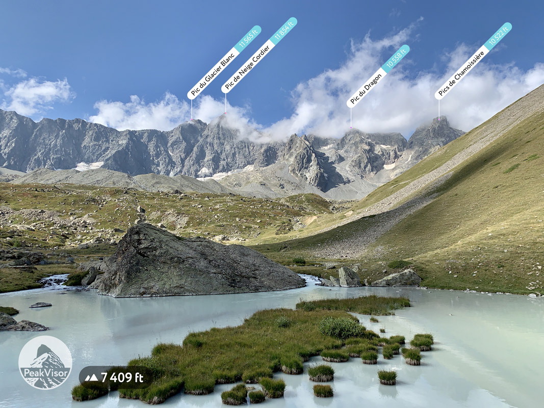
The valley is named after a small yet gorgeous glacial stream called the Petit Tabuc (small tabuc) running through it. The trailhead is located in the small village of Le Casset where hikers typically park their cars under the shadows of trees on a conveniently large parking lot. The trail is especially rich in natural wonders: glacial lakes, spectacular viewpoints, enormous jagged peaks, and ripe raspberries along the way.
The trail from Le Casset parking lot to Lac de la Douche and then to Col d’Arsine typically takes about 3 hours. From there you can return to Le Casset or proceed to Chalet-Refuge de Chamoissiere for lunch and further to Col du Lautaret (you’ll need to take a bus or a taxi to return to Le Casset).
A glacial lake close to Col d’Arsine
Flowing alongside GR54 trail, the glacial waters of the river Tabuc flow from the glacier du Casset farther up the valley.
Historically, the glacier du Casset was exploited for its ice. Workers used explosives to dislodge large sections of the glacier, these were then sent down the valley to Briançon where they were shipped by railroad to Provence and Marseille to be finally cut into smaller pieces to be offered with summer refreshment. This practice has long since been abandoned and the glacier has been preserved since.
As to the local fauna and flora, the white throated dipper is especially notable. This bird dives into the glacial waters for food. It spends its whole life near water which provides sufficient food in the cold depths.
If you think that if there’s the Petit Tabuc, there should be the Grand Tabuc as well, then you are totally right! The next valley is named after a bigger stream, hence the name. One of GR54 sections goes through Le Monetier-les-Bains and Col de l’Eychauda to the Valley de Chambran. We suggest deviating from GR54 route to the summit of Rocher de l’Yret. It is a truly spectacular location where you can see dozens (even hundreds) of peaks, have a close-up on several glaciers, and enjoy a fairy-tale lake named Lac de l’Eychauda (see the photo below). The trail takes about 3 hours one way but could be shortcut if you hop on a cable car. In any case, all the efforts are totally worth it.
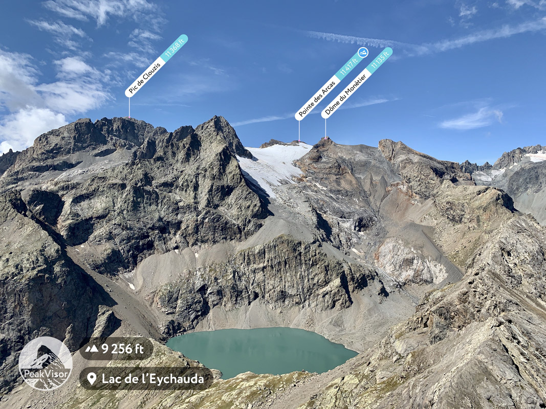
A view from the very top of Rocher de l’Yret
The river of the Grand Tabuc flows from the glacier du Monêtier which is on the mountain called des Agneaux. The river is known for its often heavy flow at the end of the winter months and during summer storms which bring a lot of rainfall in a very short span of time. The river banks swell and can slide down the mountain.
Winter has proven to be very severe in this area, with a large number of avalanches. A deadly concoction of steep slopes, heavy snowfalls and snowmelt leaves this area prone to avalanches. Large swaths of forest have been broken over time by these powerful and merciless events. Yet, these devastated forests bring new life in the form of plants, such as the blue flowers of the dauphinelle of the Dauphiné that grow alongside them in the spring and summer months.
Before the invention of winter sports, the high alpine valleys used to be a hive of agricultural activity. The acres of high mountain pastures allowed many families to build farms, chalets and huts and to live off the land. Alpine cows were raised here and families used their milk for cheeses - an activity which is proudly continued today, in a lesser degree though. It is still not an uncommon site to see herds of cattle grazing on the green grass.
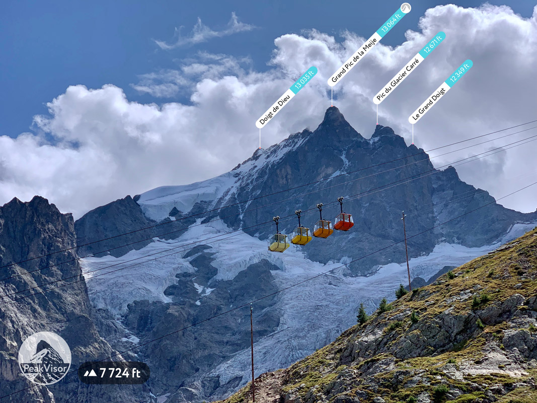
Coloured cabins of the La Grave - La Meije cable car
La Meije is the second most important peak of the Ecrins National Park with a long history in mountaineering. Starting from the small village of La Grave you can reach the glaciers in a matter of minutes should you take one of the coloured cabins running in the gradient groups of 4 (the photo above).
Every morning numerous mountaineers and outdoor enthusiasts arrive at the top station Col des Ruillans above the enormous Glacier de la Girose to start their ascents and glacier treks. The gaping crevasses of the glacier should be approached roped up and in the company of a mountain guide. For families less interested in alpinism, there are several spectacular viewpoints, a mountain restaurant with a sunny terrace, and a series of educational signposts about glaciers. For example, you might learn that the spectacular glacier de la Girose advances up to 24m (!) each year. Also, there you’ll learn what the crevasses and seracs are (you can do that soon reading our article on this very topic). Finally, on a clear day you can see Mont Blanc from there. What a treat!
Those eager to have a hike can start from the middle station and venture towards Lac de Puy Vachier, Evariste Chancel mountain hut, and the viewpoint high above very deep valley and Lac du Chambon.
Lac du Puy Vachier
A vast high altitude plateau at the very edge of the park is a perfect destination for a relaxing family hike. Several lakes, scenic photo spots, and mountain huts in the area will make the adventure delightful for everyone on the team. Probably the most convenient half day itinerary is to start from the parking lot near the remains of Chalet Josserand. From there you cross the plateau accompanied by marmots chirping and whistling to reach Lac Noir and Lac Lerie. Apart from the beauty of the plateau itself you’ll be rewarded with a spectacular reflection of La Meije and the glaciers in Lac Noir waters.
Lac Noir and La Meije
Col du Granon
Col du Granon is another bonus location which doesn’t fall within formal borders of the national park but being close to the city of Briancon and easily reachable by car via a somewhat narrow tarmac road it is a perfect place to enjoy the views of the park. On the top of the pass at the end of the tarmac road there is a large parking area and the Buvette du Granon with refreshing drinks.

Col du Granon view
From the parking area you can go along the ridge south through the summit of La Grande Peyrolle (it takes about 4 hours both ways) and even farther towards Briancon. Alternatively, you can summit a slightly closer La Gardiole (3 hours both ways). Both hikes are relatively short, boast spectacular 360-degree views, and great for families.
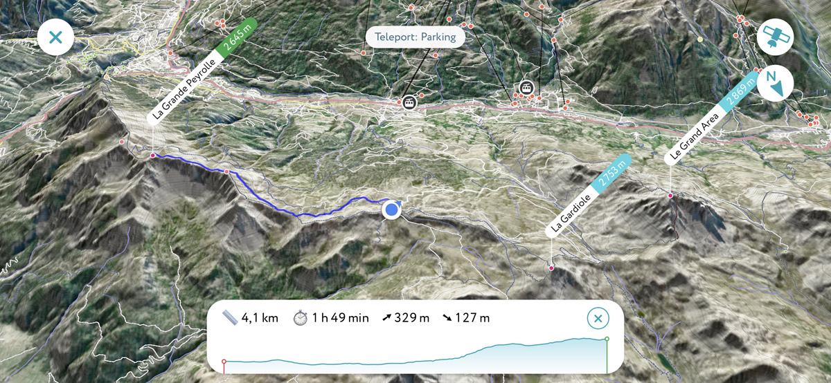
Col du Granon - La Grande Peyrolle trail
There are several major and minor cities in close proximity to the Écrins national park, offering a number of options for your base camp.
Le Bourg d’Oisans is a commune in the Isère department. It is located in the valley of the Romanche River on the route from Grenoble to Briançon. The town is famous for being the starting point of the famous cycling hill climb of the Alpe d’Huez.
Briançon is a commune in the Haute-Alpes department. It is situated just outside of the eastern border of the Écrins national park and offers an excellent starting point for excursions up to the eastern peaks. At an altitude of 1,326m, it is the highest city in France. Briançon is only 14km from the border with Italy via the ski resort of Montgenèvre. The cable car from Briançon allows easy access to Crête du Rocher Blanc at 2,550m or Sommet du Prorel at 2,556m. From the peak there are spectacular panoramas in every direction.
Gap is located south-west of the Écrins national park, and is ideally placed between the Dauhpiné Alps, the Provence-Alps and the Prealps mountain ranges. The city is situated along the famous route of Napoleon, a road symbolic of Napoleon’s northern journey through the Alps. Gap offers a perfect location for excursions into the mountains which surround the city. One of the most prominent peaks visible from Gap is Pic de Bure. It is accessible on foot and via a cable car in winter and summer months alike.
Grenoble is the largest city in the region. It is ideally suited as a basecamp for not only excursions in the Dauphiné Alps, but also for covering the Savoy Prealps to the north and the Dauphiné Prealps to the southwest. Grenoble airport is the closest to the Chartreuse range and is open all year round, however, since it is primarily catering ski-resorts in the winter, the summer flights are limited to around 3 per day. Grenoble’s train and bus stations offer further connections to the surrounding mountains and to the region.
Embrun is a small commune on the eastern shore of Lac de Serre-Ponçon in the Hautes-Alpes department. It has been nicknamed the Nice of the Alps because of its sunny climate and provincial style buildings.
There are more than 350 species of vertebrates and invertebrates. The largest populations are those of the Chamois (around 12000), the Alpine Ibex (around 600) and the typical marmotte. Grey wolves and lynx are also present in the area, with the latter thriving in the forests.
The flora varies according to the altitude in the Park. There are large swathes of coniferous forests at lower altitudes. At the sub-alpine level (1,500m - 2,000m), there are blueberries, junipers, and rhododendrons. Also, the mountain flowers of Génépi, Edelweiss and the chardon bleu are abundant in the alpine plains. Between 2,000m and 3,000m in the alpine zone, the flora is more sparse as a result of the high altitude and the long-lasting snow.
The Écrins national park has something to offer no matter the season. The best times to visit are probably during the spring and autumn months as there are fewer tourists and the weather is still quite good. For hikes in the high mountains it is best to wait until the snow has thawed completely, or be fully prepared with appropriate equipment for the adverse conditions. In the autumn months, September and October are perfect for hiking as the summer temperatures often linger on. There is also the added bonus of the autumn vibrantly colourful foliage!
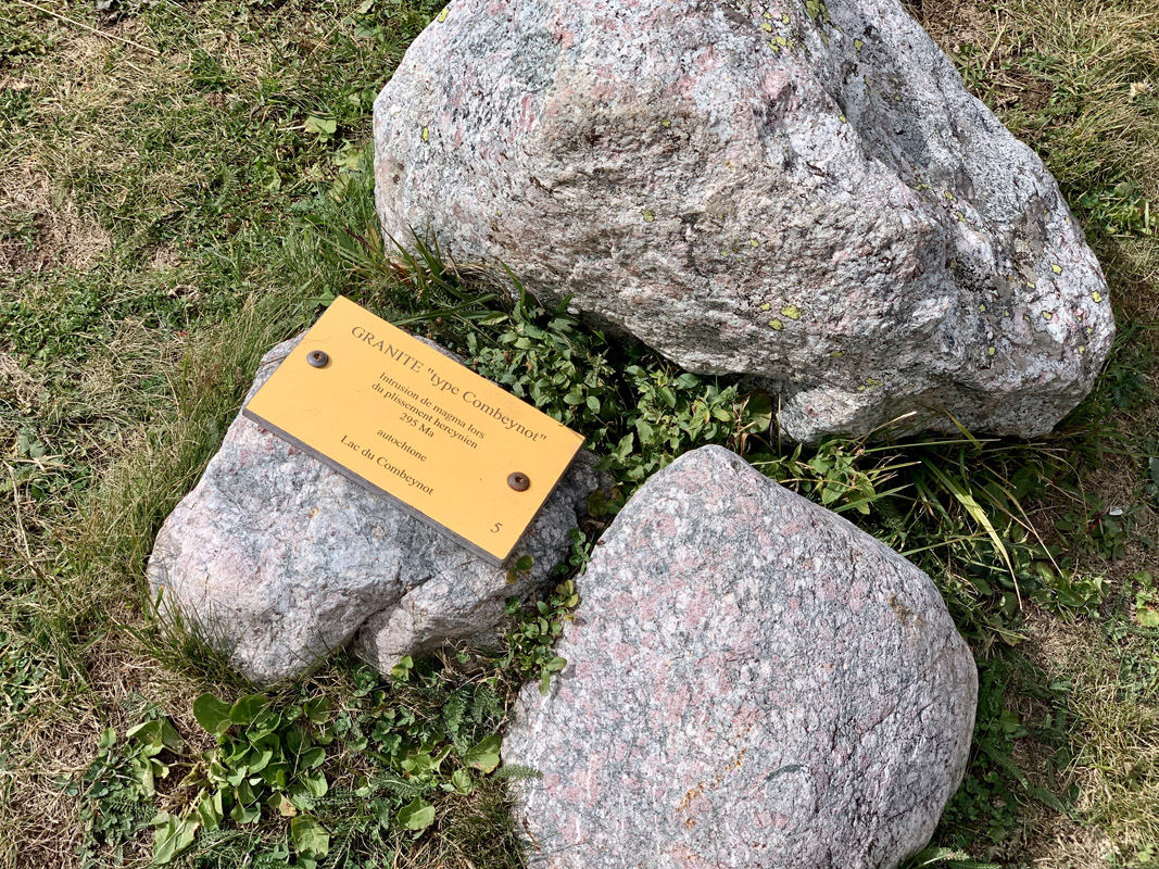
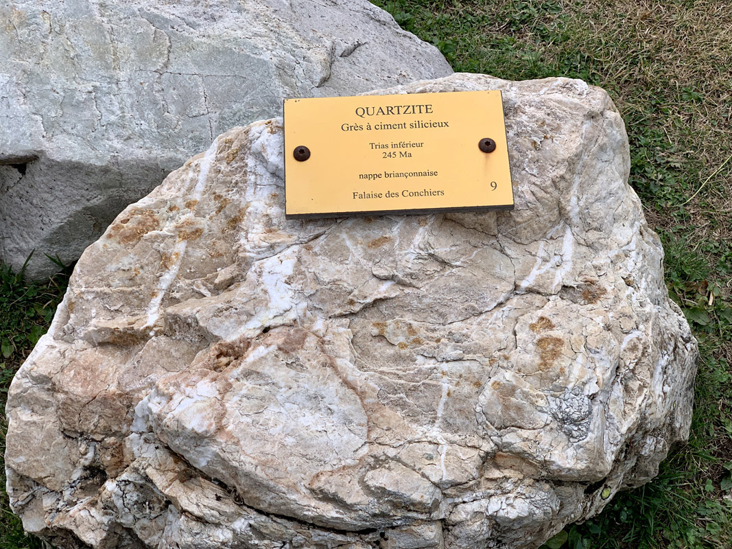
If you are puzzled how geologists distinguish all seemingly similar rocks, then you will enjoy a minerals exhibition at the top Bachas station above Le Monetier-les-Bains. There you’ll find more than a dozen huge rocks from the region with plates stating their name, age, and origin. Here are a couple of samples, so you can tell granite from quartzite!


top50
ultra
glacier
alps-4000ers
france-ultras
top50
ultra
glacier
alps-4000ers
france-ultras


