Available for connected Garmin and Suunto accounts.
Scan the QR code and open PeakVisor on your phone
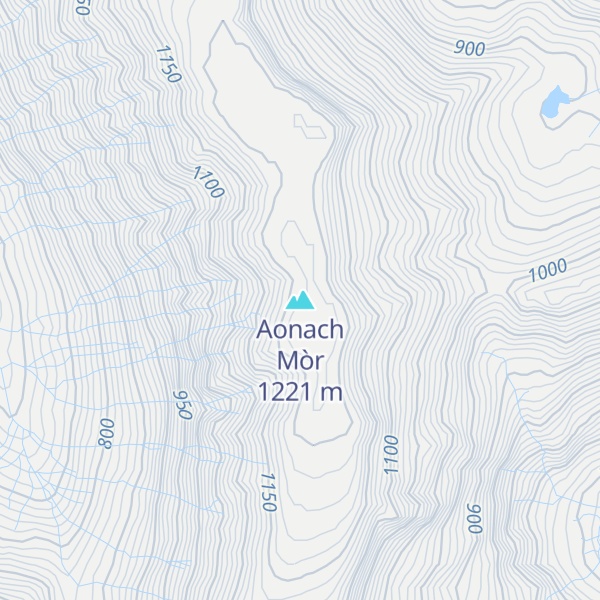
Aonach Mòr map
Aonach Mòr
Be the first photographer!
1 221 m
Elevation
Elevation is the altitude of a place above sea level.
133 m
Prominence
Peak’s prominence is the least vertical to be covered to get from the summit to any other higher terrain.
Proportional Prominence961 m
Munro
Mountains in Scotland with a height of over 914 m / 3 000 ft bear a special name, the Munros. They are named after Sir Hugh Munro, the 4th Baronet (1856–1919), who produced the first list of such hills, known as Munro’s Tables, in 1891.
Aonach Mòr is a mountain in the Scottish Highlands. It is located about two miles (three kilometres) northeast of Ben Nevis on the south side of Glen Spean, near Fort William. The mountain has a summit elevation of 4,006 ft (1,221 m) and is classified as a Munro.
The name Aonach Mòr (big ridge) might suggest that the mountain is taller than its close neighbour to the south, Aonach Beag (small ridge) to which it is linked by a high bealach. However, the names refer to the relative bulk of the mountains when seen from the glen, rather than their elevation; the summit of Aonach Mòr is 43 ft (13 m) lower than the summit of Aonach Beag.
The quickest and shortest ascent route for hikers is to take the gondola to the Snowgoose Terminal at an elevation of 2,133 ft (650 m) and then hike to the summit. More traditionally, the mountain is often climbed from the south from Glen Nevis and in conjunction with Aonach Beag.
There's a trail leading to the summit.
By elevation Aonach Mòr is
# 8 out of 4967 in Highland # 12 out of 18277 in Scotland # 12 out of 34760 in United Kingdom # 12 out of 5485 in the Grampian Mountains
We use GPS information embedded into the photo when it is available.
3D mountains overlay
Adjust mountain panorama to perfectly match your photos because recorded by camera photo position might be imprecise.
Move tool
Rotate tool
Zoom
More customization
Choose which peak labels should make into the final photo and what photo title should be.
Next
Photo Location
Satellitte
Flat map
Relief map
Latitude
Longitude
Altitude
OR
Latitude
°'''
Longitude
°'''
Apply
Register Peak
Peak Name
Latitude
Longitude
Altitude
Register
Teleport
PeakVisor
This 3D model of Sagarmatha National Park in Nepal was made using the PeakVisor app topographic data. The mobile app features higher precision models worldwide, more topographic details, and works offline. Download PeakVisor maps today.
Download OBJ model
PeakVisor
The download should start shortly. If you find it useful please consider supporting the PeakVisor app.
PeakVisor for iOS and Android
Be a superhero of outdoor navigation with state-of-the-art 3D maps and mountain identification in the palm of your hand!