
Scan the QR code and open PeakVisor on your phone
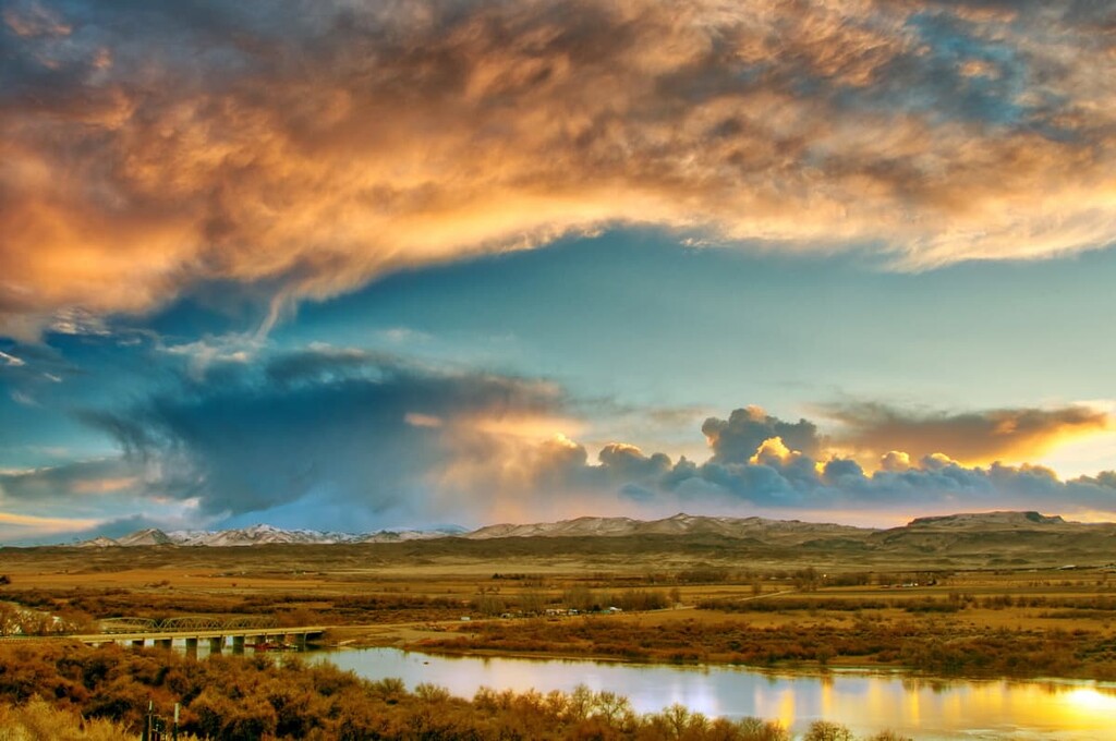
The Owyhee River Wilderness is a vast, remote region in the US state of Idaho, home to steep canyons, whitewater rapids, and hundreds of thousands of acres of wild land. There are 12 named peaks in the area, the highest of which is Bald Mountain at 6,138 ft (1,871 m).
The Owyhee River Wilderness occupies the southwest corner of Idaho, stretching from the Oregon border east to the Duck Valley Indian Reservation of the Shoshone-Paiute Tribes and south to the Nevada border.
The wilderness area itself covers more than 267,000 acres (108,000 ha) of land, including parts of the Owyhee Mountains. It’s part of a massive complex of federally managed wildlands covering millions of acres in Oregon, Idaho, and Nevada.
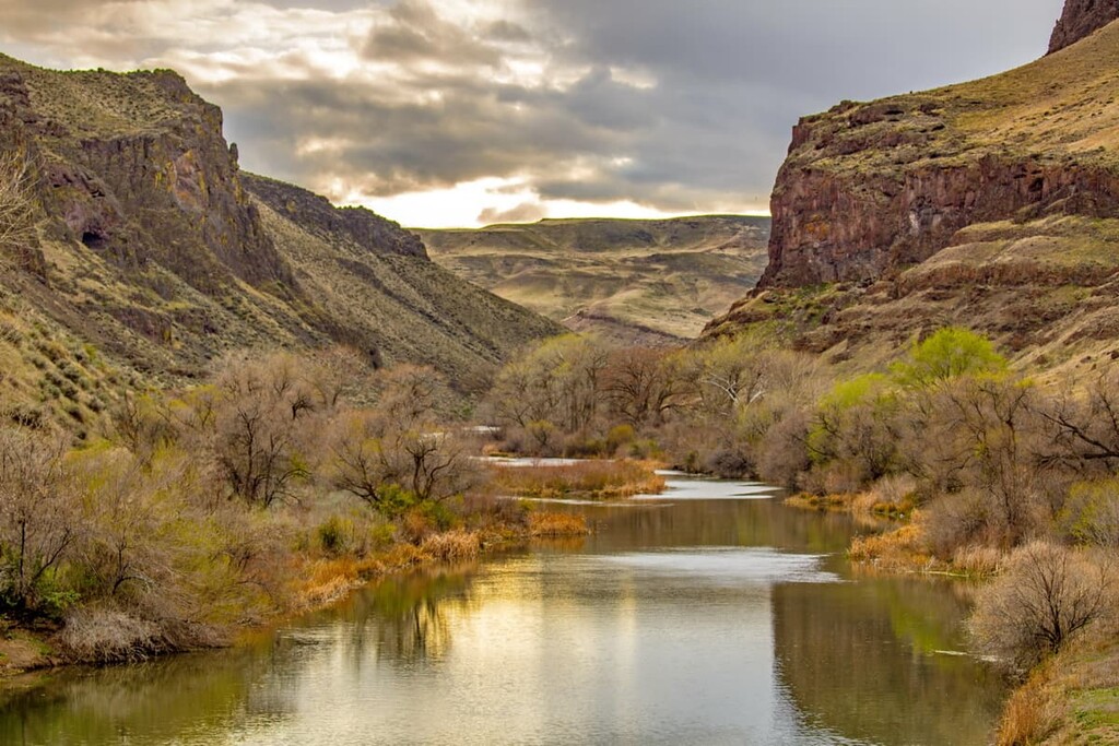
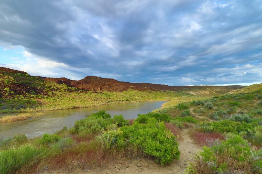
The Owyhee River Wilderness is part of the Owyhee Desert, which receives an average of about 4 inches (10 cm) of rain per year. The area’s boundaries largely follow the major waterways in the region, the Owyhee, Bruneau, and Jarbidge rivers. Most of the wilderness area is made up of deep canyons and the surrounding plateaus.
The terrain in the Owyhee River Wilderness is extremely remote, rugged and difficult to access. The few roads in the wilderness and the surrounding region are challenging even for four wheel drive vehicles with high clearance. There are limited footpaths in the wilderness and most hiking has to be done off-trail, with a map and compass.
The Owyhee River Wilderness is administered by the Federal Bureau of Land Management (BLM) and it was first established in 2009. It’s the second largest wilderness area in the US not located inside a national park, forest, or wildlife refuge.
As a federally designated wilderness area, any motorized or mechanical recreation (even bicycles) are prohibited in the Owyhee River Wilderness outside of designated access roads. River rafting is popular here and one of the best ways to see the area.

The Owyhee River Wilderness is surrounded by other wild lands and the whole area is collectively referred to as the Owyhee Canyonlands Wilderness Areas. The Bruneau-Jarbidge Rivers Wilderness Area, the North Fork Owyhee Wilderness, the Pole Creek Wilderness, the Owyhee River Canyon Wilderness Study Area, and the Big Jacks and Little Jacks Creek Wilderness areas are all nearby.
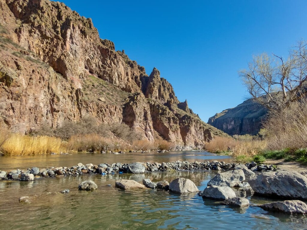
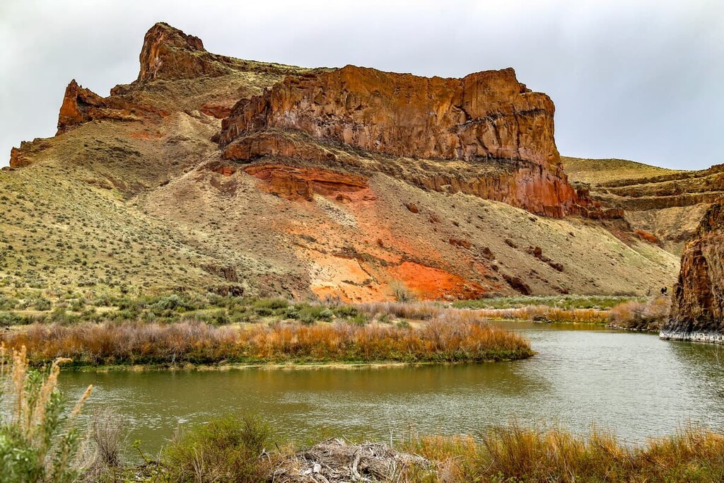
The Owyhee River Wilderness sits in the high basalt plateaus of the Owyhee Desert. Much of the exposed rock here was formed by massive volcanic eruptions that took place over the last 17 million years, making the rock fairly young in geological terms.
The volcanic hotspot that flooded the Owyhee River area with lava millions of years ago is still causing volcanic and geothermal activity today, 400 miles away under Yellowstone National Park. The hotspot that creates the geysers and hot springs in Yellowstone is stationary under the Earth’s crust, and the North American continental plate has drifted southwest over it in the past 20 million years or so.
This has caused the hotspot to appear to move northeast across the Snake River Plain to its present location in the northwest corner of Wyoming. The Yellowstone hotspot has erupted at least half a dozen times in this area.
The Owyhee River Wilderness is one of the oldest of these former Yellowstone Calderas, having erupted between 13 and 15 million years ago. Most of the rocks in the area are extrusive igneous rhyolites and basalts from the Pliocene and Miocene epochs, originating from these eruptions.
In between eruptions, layers of softer sedimentary rock built up, including weakly consolidated sandstone, siltstone, arkose, and conglomerates. Over the years, the Owyhee River and its tributaries cut deeply through the plateau, creating the dramatic canyons we see today. The alternating layers of these sedimentary and volcanic rocks are visible as striations in the canyon walls today.
The Owyhee River is a tributary of the Snake River and part of the larger Columbia River Drainage Basin. The highest point in the Owyhee River Wilderness is Bald Mountain, followed by Spring Butte and Cavieta Hill.
Despite the challenging desert climate and rugged terrain, more than 200 species of plants and animals live in the Owyhee River Wilderness. Due to the low population density and general remoteness, this area makes a great habitat for large mammals like cougars, elk, mule deer, pronghorn, and the largest herd of California Bighorn sheep in the country.
Birds in the Owyhee River Wilderness include prairie falcons, golden eagles, and the greater sage-grouse, which is considered a threatened species. There are also 14 species of bats in the area.
In terms of plant life, the Owyhee Canyonlands region is quite biodiverse. The area is particularly well known for its wildflowers, which bloom in late spring and early summer. There are more than two dozen species of plants in the area that grow nowhere else in the world, including Packard’s Blazing Star and Owyhee clover. Some of the other notable wildflowers in the area are lupine, stark bitterroot, and Bruneau River Flox.
The Owyhee Canyonlands region has been inhabited for at least 12,000 years. The area is the traditional territory of the Northern Paiute, Bannock, and Shoshone tribes, all of whom historically lived across the Great Basin region.
They traditionally speak languages in the Numic group, the northernmost branch of the Uto-Aztecan language family. Some of these languages are still in use today on the Duck Valley Indian Reservation, which is home to the Shoshone-Paiute Tribes, located just outside the wilderness area.
There are over 500 known archeological sites in the Owyhee Canyon Wilderness, including pictographs, petroglyphs, shrines, campsites, rock alignments, and hunting blinds. Numerous artifacts have been found in the area, including clay figurines, woven baskets, and shoes, along with weapons and tools made from obsidian, agate, jasper, and opalite.
The Indigenous peoples in the area were traditionally semi-nomadic and moved through the Owyhee Canyonlands frequently, but they didn’t leave behind many permanent settlements in the area. One local legend about a hostile creature called “Tsa-hau-bitts,” or “Jahabich” eventually lent its name to the Jarbidge Canyon, where it supposedly lived.
The name “Owyhee”, however, comes from an older spelling of the word “Hawaiʻi” (This spelling, which was common in the early 1800s, is phonetically closer to the Hawaiian language pronunciation.) The area was named for three Hawaiian members of an early expedition party who went missing in the Owyhee Canyonlands in 1820.
In the eighteenth and nineteenth centuries, settlers of European descent slowly began to move into the area. The remains of these early homestead and ranching sites are still visible around the Owyhee Canyonlands. Increasing numbers of settlers and hostility toward Indigenous peoples led to the removal of Indigenous peoples from their land and the creation of the Duck Valley Indian Reservation in 1877.
Less than ten years later, the Western Shoshone Tribe successfully resisted efforts to remove them from their homelands and relocate the Tribe to another reservation in Idaho. In 1886, Northern Paiute who had participated in the Bannock War were released from a prison camp in Yakima, Washington and allowed to return to their homelands in the Owyhee Canyonlands area. The Duck Valley Indian Reservation was expanded so they could settle there.
Over 1,700 members of the Shoshone-Paiute Tribes live on the reservation today. The tribal nations worked with the Idaho Department of Fish and Game to reintroduce Chinook Salmon to the Owyhee River in 2015. The salmon, which are important to the tribal nations for ceremonial and cultural practices, were absent from the river for 87 years after the construction of dams on the river.
In 2009, the Omnibus Public Land Management Act designated the Owyhee River Wilderness as a permanently protected wilderness area.
The Owyhee River Wilderness is genuinely remote land—there are almost no roads (both paved and unpaved) and few defined hiking trails.
You’ll likely need a vehicle with four-wheel drive and high clearance just to get to the Owyhee River Wilderness. Remember that no motorized vehicles are allowed in the wilderness area, so you’ll have to continue on foot once you reach the wilderness boundary.
Rafting is the main outdoor activity in the area, but with a map and compass or GPS, and a willingness to navigate off-trail, you can venture into the Owyhee River Wilderness on foot. The area is also popular for off-road driving.
The Tules, sometimes called the Owyhee Meanders, features towering cliffs and incredible 180-degree river bends reminiscent of Horseshoe Bend in Arizona. Unlike the popular Arizona Canyon, you’re not likely to see many people (if anyone) hiking in this area.
Because this area is so remote, you’ll want to fill your gas tank before heading into the area. The closest (and only) gas station near this part of the wilderness area is Our Grocery Store in Owyhee, Nevada. From the gas station, turn right onto Boney Lane and then right onto Pleasant Valley Road.
Pleasant Valley Road turns to dirt and extends north over the Idaho border. After about 20 miles (32 km), you’ll come to a gas pumping station where you can leave your car. Signage is poor here and regular road maps won’t show all of the roads in this area, so make sure to download or print your own maps. The Bureau of Land Management provides georeferenced PDF maps.
Once you leave your car, hike northeast to meet the canyon, then continue north along the rim to reach the Tules. If you follow the rim closely, it’s about 8 miles (12.8 km) to The Tules. While the hike looks flat, there are lots of minor ups and downs.
Remember, this a trailless backcountry trek, not a standard hike. You’re responsible for navigating and keeping track of your location at all times. Bring a map and compass and make note of landmarks around you so you can find your way back to your car. This hike is also totally exposed, so bring lots of water and beware the midday heat.
This remote stretch of the Owyhee features some of the tallest cliffs on the river. Towering 1,000 ft (305 m) high canyon walls house one of the most concentrated populations of raptors in the mountain west. It’s estimated there’s a raptor nest every 3 miles (3.8 km) in this part of the canyon.
The best way to see the canyon is from the river. Several different rafting companies offer multi-day trips that pass through Green Dragon Canyon.
One of the main draws to the Owyhee River Wilderness is that there’s not much other than stunning landscapes nearby. If you’re planning to visit rural southwest Idaho however, you’ll probably have to pass through one of these towns to get there.
Located about 150 driving miles (240 km) from the eastern reaches of the Owyhee River Wilderness, Twin Falls is one of the largest towns in southern Idaho and the county seat of Twin Falls.
About 45,000 people live in the town, which is the largest for about 100 miles (160 km). Downtown Twin Falls was revitalized in recent years with new public spaces, and there are lots of breweries and restaurants to choose from.
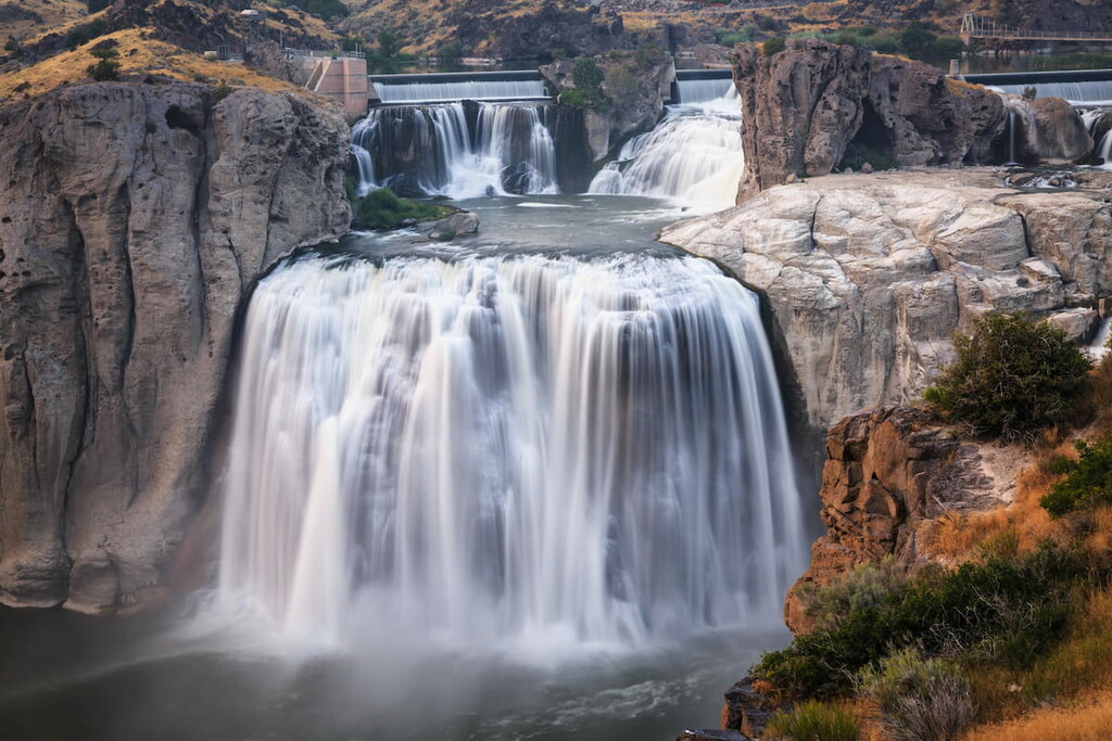
Most of the attractions in Twin Falls center around the Snake River Canyon, including scenic trails, rock climbing, and zip lines. The most famous attraction in town is Shoshone Falls, a 200 ft (60 m) waterfall on the Snake River called “the Niagra Falls of the West.”
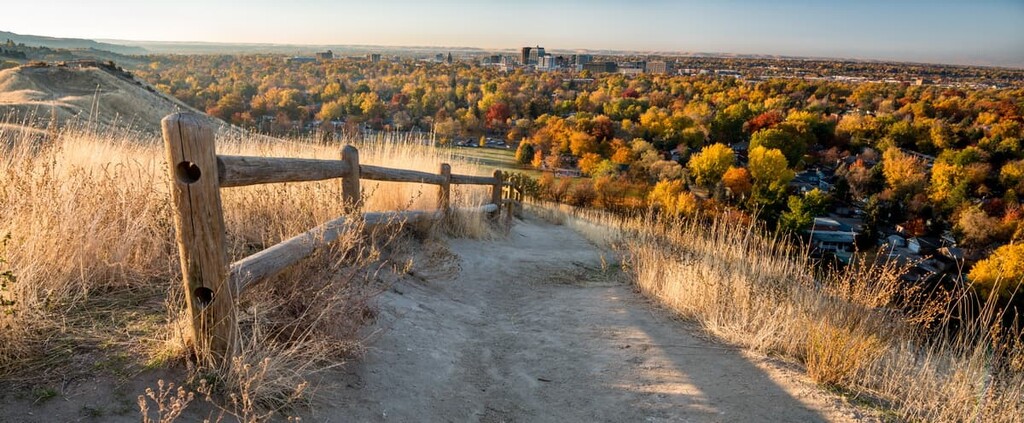
Boise is the capital of Idaho and its most populous city, with over 240,000 residents. Boise has the largest airport in Idaho (and the only international airport), so there’s a good chance you’ll be coming through the city if you’re flying in.
Boise is an outdoorsy, approachable city with extensive bike lanes and a 25 mile (40 km) greenbelt along the Boise River through the center of the city. The town is an arts and culture capital, with plenty of museums, galleries and a summer Shakespeare Festival.


