Scan the QR code and open PeakVisor on your phone
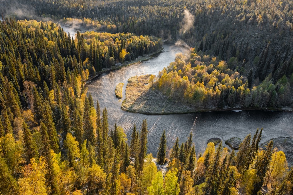
Oulanka National Park is one of Finland’s most popular national parks, located in Lapland region. The main feature that gives the park its name is the Oulanka River (Oulankajoki in Finnish, Olanga in Russian), which winds for more than a hundred kilometers (miles) through the wild landscapes at the junction of the forest belt and arctic tundra. It has many rapids and high cliffs—say, the natural viewpoints, making it as picturesque as possible. The Karhunkierros Trail, the most popular hiking trail in the entire country, runs along the river accordingly. There are 3 named mountains in Oulanka National Park. The highest and most prominent mountain is Korvasvaara (326 m / 1,069 ft).
The park gets its name from the Oulanki River, the full name of which is spelled Oulankajoki in Finnish, where "joki" is the actual river.
Oulanka is one of the longest rivers in Lapland, which begins in Ulkujarvi Lake, some 70 km (43.4 mi) to the east of Rovaniemi, the capital and largest city of the region, and flows eastward across the border between Russia and Finland, until it goes into the Pyaozero (Pääjärvi) Lake in the Paanajärvi National Park in the Republic of Karelia, and from there into the White Sea via larger Kovda River (233 km / 145 mi) in the Murmansk Oblast. The total length of the river is 135 km (83.8 mi). It is roughly equally divided among the countries of 67 km (41.6 mi) in each.

So Oulanka River is the main river of not one but two national parks (Oulanka and Paanajärvi), regions (Lapland and Karelia) and countries (Finland and Russia).
This incredibly winding river with its many rapids also changes its name in Russia to Olanga. This name comes from the native Russian Karelians.
The full name of the park itself in Finnish is Oulangan kansallispuisto.
Oulanka National Park is situated on the border of Finland’s two largest regions, Lapland to the north and Northern Ostrobothnia to the south. The park is 40 km (mi) south of Salla and 50 km (31 mi) north of Kuusamo, the two nearest largest settlements, the latter being much larger with 15,000+ inhabitants vs 3,000+ in Sala. The closest villages to Oulanka National Park are Käylä, Juuma, and Hautajärvi. The nearest railway station is Kemijärvi, 130 km (80 mi) away.
Accordingly, you can get to the park from all these cities by car or bus, as the bus service is very well developed, both in summer and in winter. You can even take a bus to the park from Rovaniemi or from the even more distant Baltic Sea city of Oulu, the capital of Northern Ostrobothnia. The nearest airport is Kuusamo, where there are regular flights from Helsinki. Slightly more distant airports are located in Ivalo and Rovaniemi.
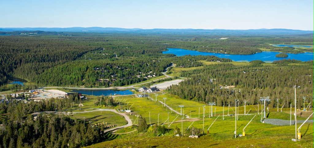
The park itself consists of two large parts—northern and southern, between which the map of the park shows a “gap”—the unprotected area. Further south is also the small Valtavaara-Pyhävaara Nature Reserve (Valtavaara-Pyhävaara luonnonsuojelualue) near the village and ski resort of Ruka, one of the biggest in Finland. Ruka is the finish point of the Karhunkierros Trail from the south (to the north it is Hautajärvi).
Oulanka National Park is located at the junction of the forest belt of Northern Ostrobothnia and more southern parts of the country and the arctic tundra of Lapland. This is one of two obvious features of the park's flora. The second one is the incredibly beautiful calypso orchid, which is hard to imagine in these harsh northern lands until you see it with your own eyes. It looks more like an insect than a plant, it looks alive. It also appears on the park's emblem, which every Finnish national park has.
The fauna of the park includes all the typical animals of both regions from fish and reptiles to small rodents and medium-sized animals like hares, foxes, and wolves to big ones like bears, moose, and of course reindeer. The latter are particularly abundant here. There are also a lot of birds.
In total, Oulanka National Park has more than 400 species of protected plants and animals, which grow and live in more than 4,000 specific locations.
There are 3 named mountains in Oulanka National Park. The tallest of them, Korvasvaara (333 m / 1,092 ft), is located in the extreme south of the northern part of the park on the border with Russia, not on the Karhunkierros Trail, which you probably won’t get to. But the other two, Hiidenvaara (270 m / 885 ft) and Jäkälävaara (243 m / 797 ft), are in the center of the southern part of the park directly on the trail, so you can climb them to see the surroundings. Their height of over 200 m (656 ft) is also quite good by the standards of the generally low mountains of Eastern Finland, which belongs to the Karelides range.
Among the other famous mountains, rocks and cliffs of the park can also be identified as a minimum of four:

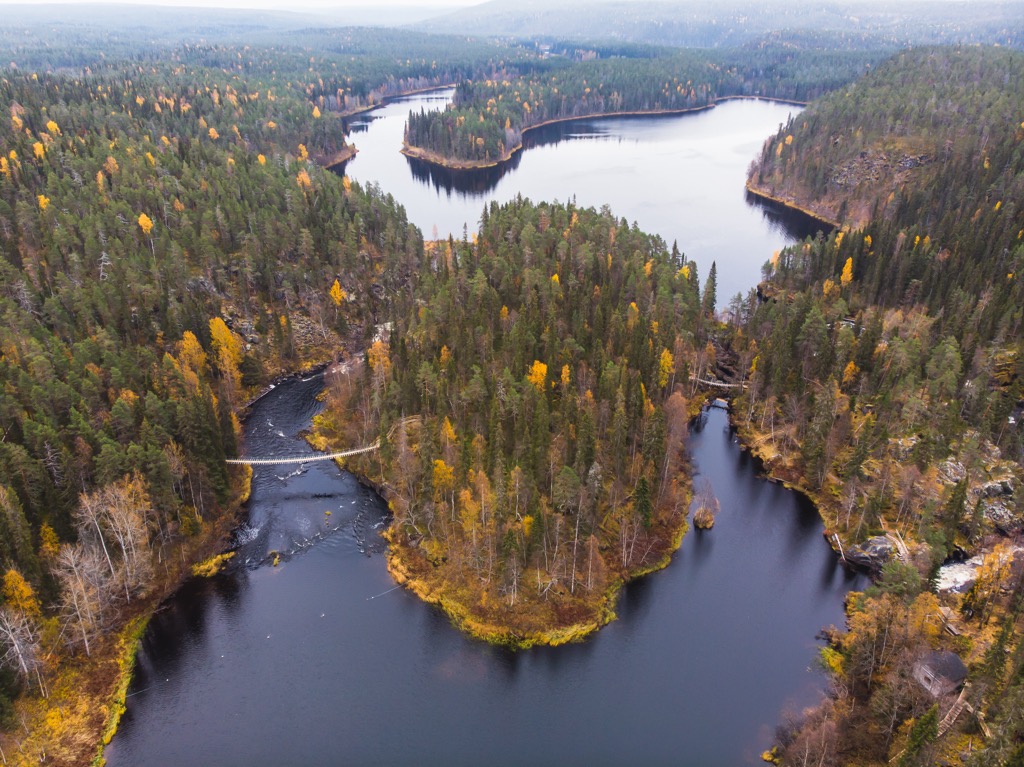
Another feature of the Oulanka mountains are actually numerous rapids on the river, which can be observed from the tops, as well as (and no less importantly) heard during the hike. The main rapids are as follows: Taivalköngäs, Kiutaköngäs, Niskakoski, and Jyrävä. Many of them can be approached up close at different parts of the Karhunkierros Trail from different locations such as Oulanka Visitor Center or Oulanka Camping Ground.
So Karhunkierros Trail is the main and most famous trail of the Oulanka National Park. Moreover, it is the most popular hiking trail in Finland, which attracts hundreds of thousands of tourists every year. This is due in part to the fact that the park itself with all its attractions close to the top 5 most visited in the country with 253,300 visitors in 2021 after Pallas-Yllästunturi National Park (699,200), Urho Kekkonen National Park (446,300), Nuuksio National Park (314,500), and Koli National Park (256,900). Karhunkierros is the subject of a guide the size of this one, so here are just the most important facts to know:

In addition to Karhunkierros, there is also Keroharjun kuiskaus Trail of 17 km (10.5 mi) long, which runs along the entire northern part of the park. It goes one way, but you can try to get to the park's southern part via local road 8693. Trails in the Ruka area are represented by three separate circular trails up to 6 km (3.7 mi).
As it has already become clear, Ruka is the nearest ski resort to Oulanka. It is one of the largest and most popular resorts in the country. It offers more than 20 km (12.4 mi) of slopes and more than 20 ski lifts. There are also 240 km (mi) of cross-country ski trails.
To the north and west of the park are also two smaller resorts: Sala Ski Resort in the village of the same name with more than 10 km (6 mi) of slopes and more than 5 ski lifts, and Suomu Ski Resort in the village of Kemijärvi with more than 13 km (8 mi) of slopes and more than 5 ski lifts.

Check the Lapland and Finland ski resorts map in the World Mountain Lifts section of the site. It includes information about open ski lifts / slopes in Finland in real-time with opening dates and hours. There are also year-round cable cars, funiculars, cog railways, aerial tramways, and all other types of mountain lifts.
Before or after the hike, visit one of its three official visitor centers to pick up a paper map and booklets, ask for advice, and buy souvenirs from Lapland:
Karhunkierros Visitor Centre in Hautajärvi
Hautajärventie, 414, 98995, Salla, Finland
+358400196741
Oulanka Visitor Centre in the middle of the park north of Laitila
Oulangan luontokeskus, Liikasenvaarantie, 132, 93900, Kuusamo, Finland
+358206396850
Kuusamo Customer Service Karhuntassu in Kuusamo
Torangintaival, 2, 93600, Kuusamo, Finland
+358206396804

Unlike the less popular areas in Finland, in Oulanka National Park you will have no problem finding a place to stay if you come here during the off-season. Otherwise, the number of free places may be very limited. In particular, the park has 7 open wilderness huts; 1 day trip hut and several lean-to shelters, which can be also used for overnight stay during the summer; and 50 camping and campfire sites where you can pitch your tent. There is also the official Oulanka Camping Ground, which is located right on the Karhunkierros Trail in the center of the park, and several private campings in Juuma such as Basecamp Oulanka and Oulanka Camping, another one with the similar name.
At the end, check again the three closest localities to Oulanka National Park from which the Karhunkierros Trail is best accessed, so you remember them for sure. These are Hautajärvi in the north, Juuma in the south (and in the center of Karhunkierros) and Ruka in the south of the entire route. The nearest town is Kuusamo in the south, as well as two larger villages of Sala in the north, and Kemijärvi in the west, compared to the ones on the park’s borders. The nearest real city is Rovaniemi, the capital of Lapland, 172 km (106 mi) away from the start of the trail in the north of the park.