Scan the QR code and open PeakVisor on your phone
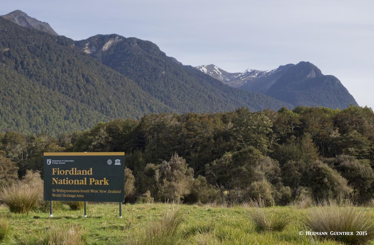
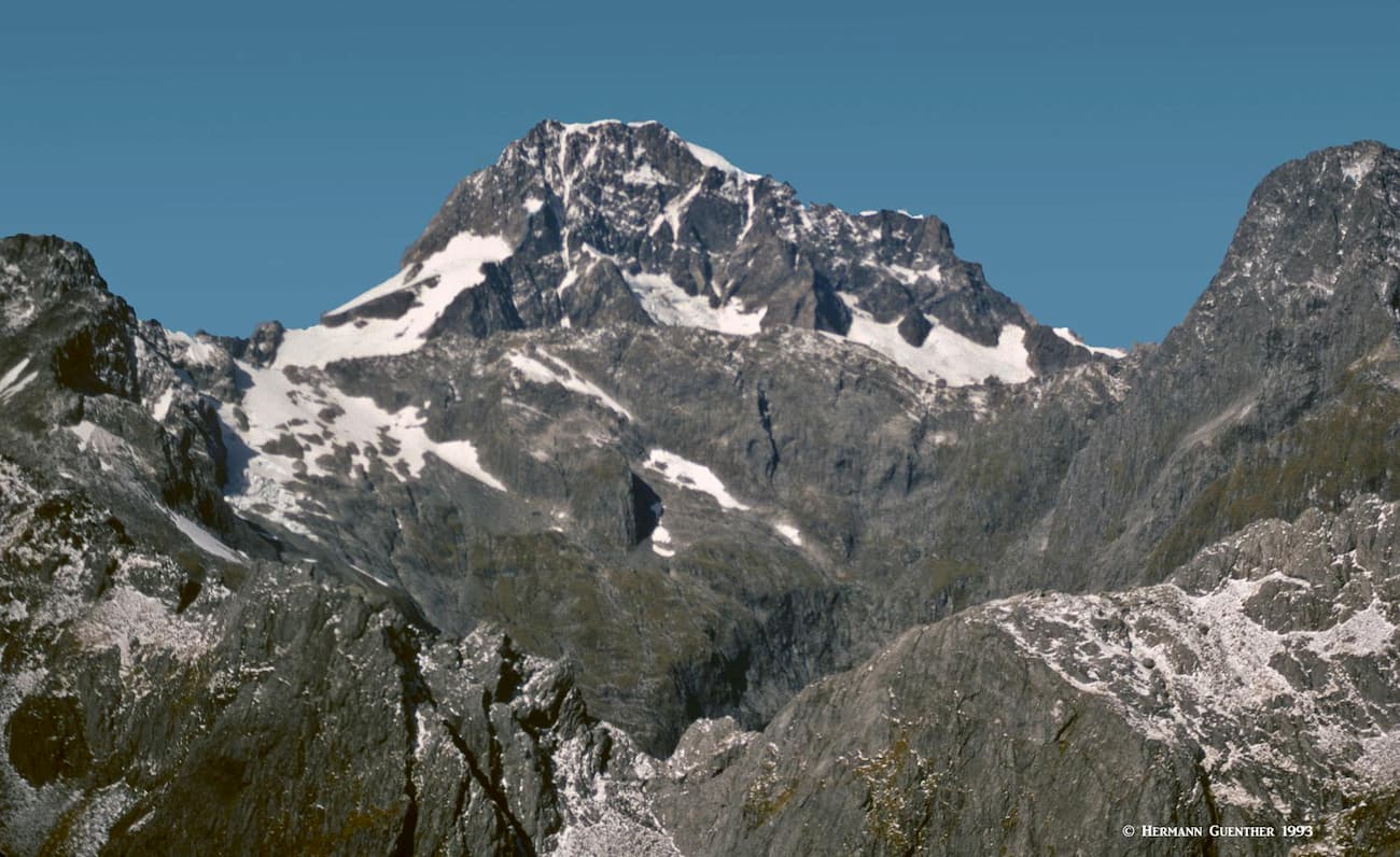
Fiordland National Park occupies the southwest segment of New Zealand’s South Island. It is overwhelmingly the largest of the 13 national parks in the country, with an area of 12,607 square kilometers (4,868 square miles). To put this into perspective, that is 40% larger than Yellowstone National Park in the United States. Fiordland has 884 named mountains – the highest and most prominent is Mount Tūtoko.
The park was originally set aside as a national preserve in 1904, at which time there were only two national parks in the country – Tongariro and Egmont. Then the National Parks Act of 1952 consolidated the three, thus making Fiordland the third national park in New Zealand. In 1986, the park was recognized as a UNESCO World Heritage Site. In 1990 it became part of the Te Wahipounamu World Heritage Area, which includes three other national parks to the north (Westland Tai Poutini, Aoraki/Mount Cook and Mount Aspiring National Parks).
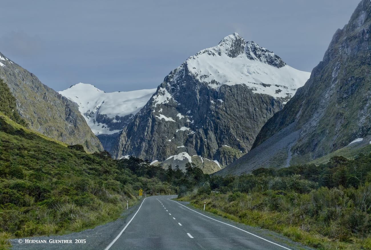
There is only one main road into the park, the Te Anau-Milford Highway (State Highway 94). But it wasn’t always there – it reached the site of the Homer Tunnel in 1935, and only after the tunnel was completed in 1953 did Milford Sound become accessible by road. And what a road it is. Starting at the town of Te Anau, the highway skirts the edge of the park before entering it at the Eglington Valley just north of Te Anau Downs. There are a few other minor unsealed roads that provide access to entry points into the park, mainly to hiking trails (tramping tracks in Kiwi-talk) and remote campsites.
Fiordland National Park is the most popular national park in the country, with over a half million foreign visitors gravitating to the park every year. But these visitors almost exclusively visit the northeastern part of the park between Te Anau and Milford Sound (“Piopiotahi”). That section of the park is truly spectacular and its easy accessibility via the only highway makes this the obvious target for the masses. Not only is Milford Sound one of the most spectacular fiords on the planet, the drive to get there is beyond description. Therefore, the highway can get very busy, especially these days of mass tourism. Extreme care is essential, since there is always the temptation to let your eyes wander. There are plenty of places to pull over and stop to admire the scenery.
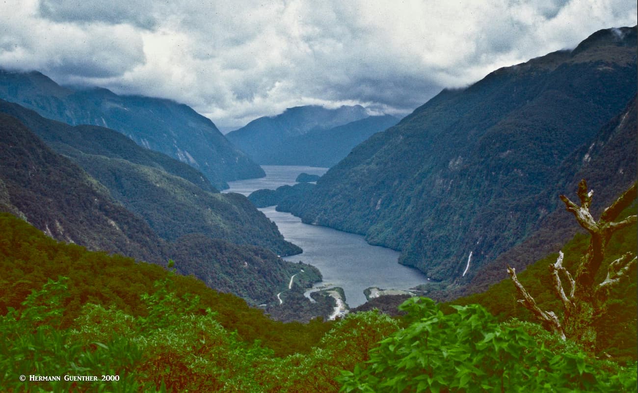
But most of what the park is named for, some 15 deep fiords reaching up to 40 kilometers (25 miles) inland, is rarely, if ever, seen by most tourists. Even most locals don’t dare to venture into this remote hinterland. The only access is on foot or by sea. The many mountains in the park, the southern ranges of the Southern Alps, are rarely climbed, simply because you just can’t get to them, the exception being those that are closer to the main highway and that can be reached by maintained hiking trails.
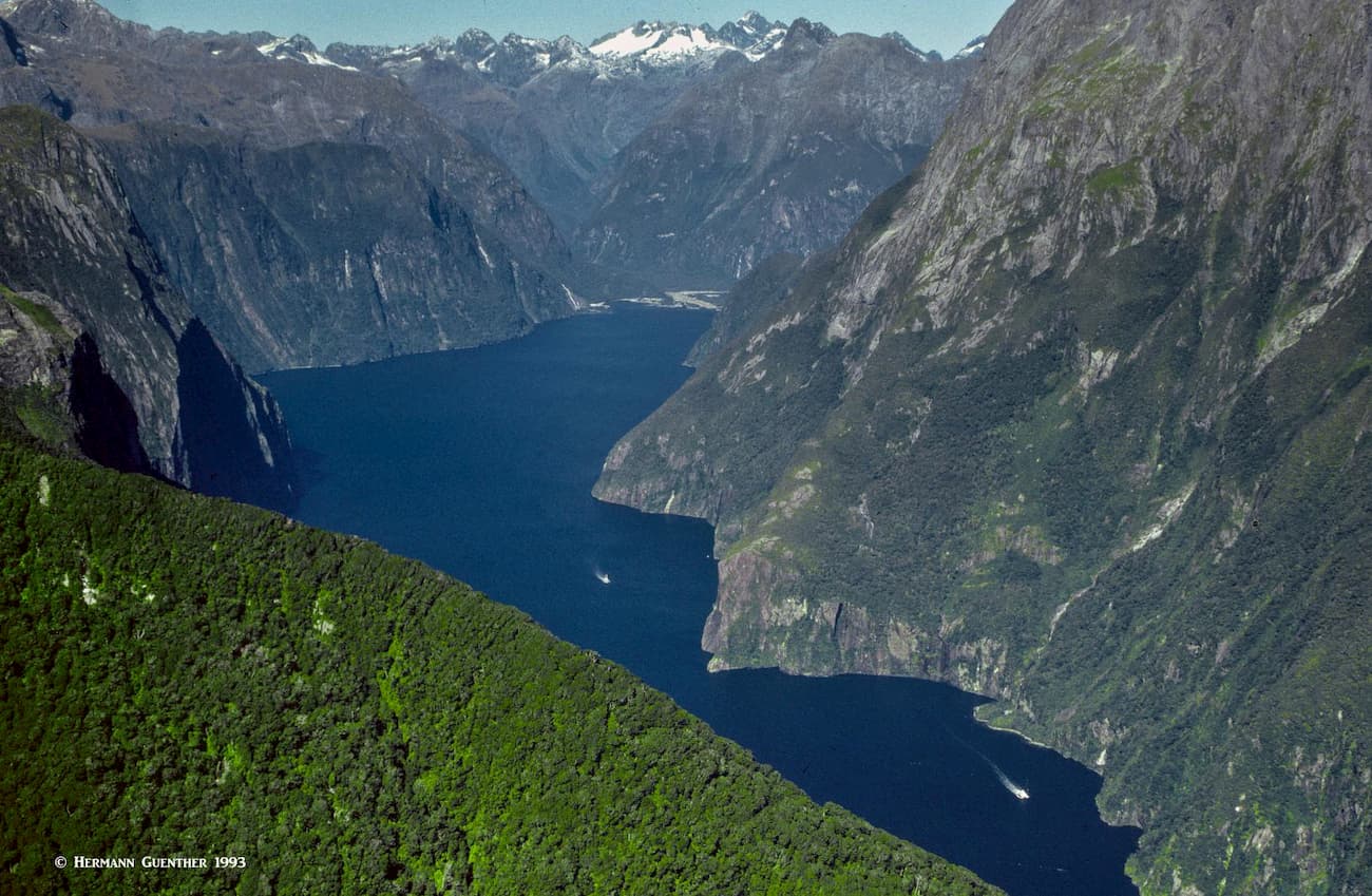
There is one fiord in addition to Milford Sound that could be considered a tourist destination. But it does not begin to approach the popularity of Milford Sound. That is Doubtful Sound, which requires a full-day time commitment to see. And that is if you are already based in or near the small town of Manapouri, 22 kilometers (13 miles) south of Te Anau. This entails a boat cruise to the far end of Lake Manapouri, from where a dedicated shuttle bus takes you overland across Wilmot Pass on a gravel road to a small jetty at the tip of Doubtful Sound. A boat then takes you the full length of the sound to its entrance at the Tasman Sea. The return to your starting point is the same route that you just came. This will take an entire day, but the experience is truly worth the time and expense.
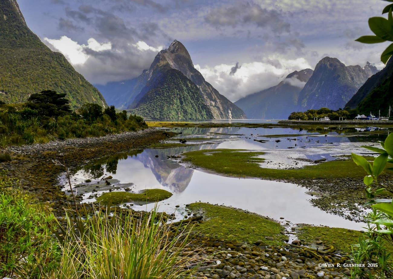
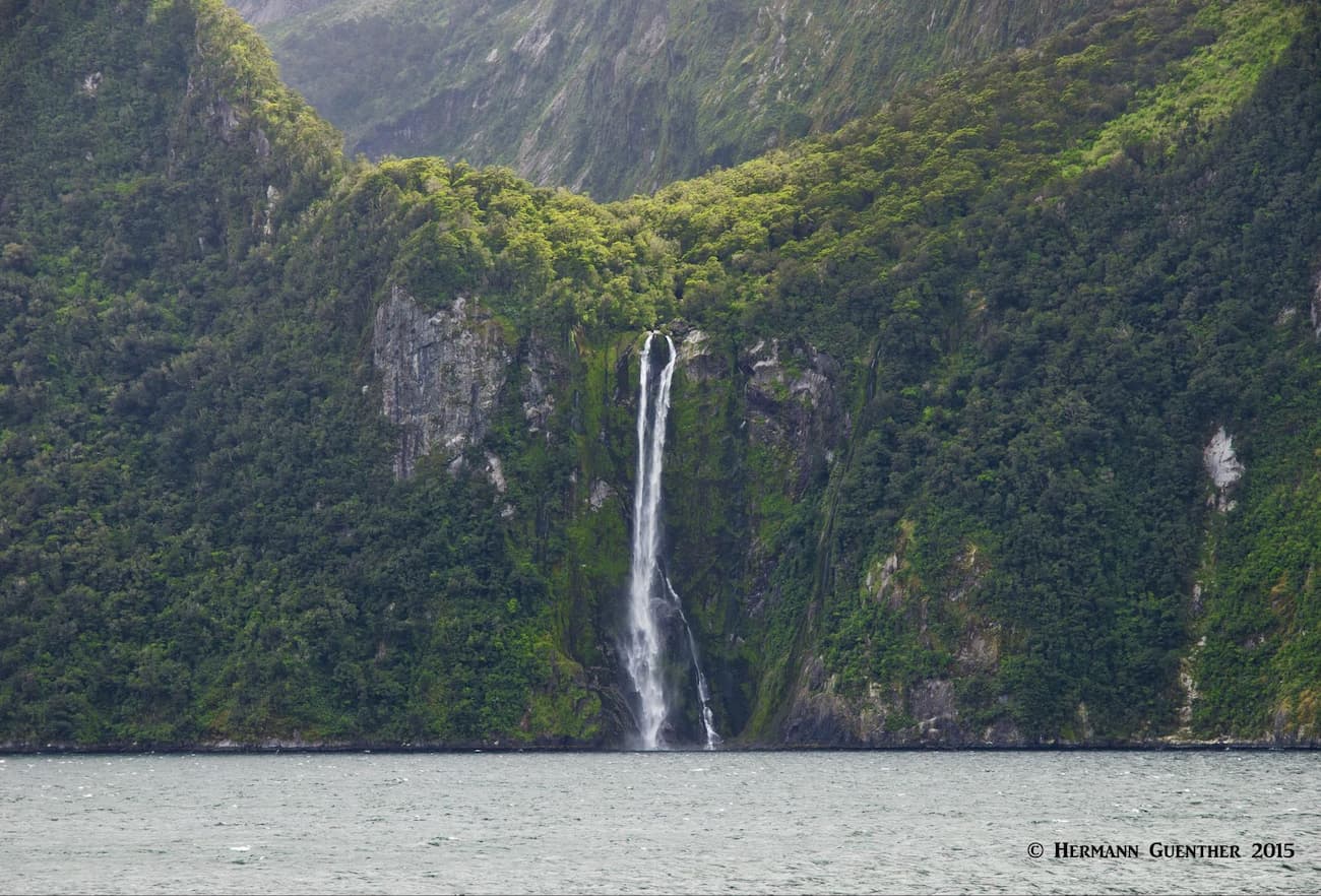
Now, one other thing that makes Fiordland so special, or infamous, is the weather. Yes, it rains here a lot – after all this is one of the wettest places on earth. Milford Sound, for example, receives 6,700 mm (22 feet) of rainfall a year. Yet the terrain has a major influence on the amount of precipitation – on the east side of the mountains in Te Anau, the average annual equivalent rainfall is only about 1,200 mm (47 inches or less than four feet). This might discourage many visitors, but it should not. While I have been in Milford three times and have had favorable weather each time, others have told me that a cruise on the sound during heavy rain can be very dramatic, with hundreds of short-term waterfalls cascading down the steep cliffs. Even if the weather is nice, the 155-meter (508 feet) tall Stirling Falls is impressive any time.
Tourism in Fiordland National Park is big business. It attracts visitors by the busload, most of which go to see the spectacular Milford Sound and to take a boat cruise on the sound to its opening into the Tasman Sea. Many of these tourists will come from Queenstown, 282 kilometers (175 miles) distant, arrive at the dockside to take one of the many two-hour cruises on offer there, and then make the return trip to Queenstown. That is typically a 14-hour day. Not for everybody, but thousands of people do it regularly. They are missing much of what this awesome area has to offer. I have done the Milford Sound experience three times, but by driving there myself (with my wife of course). There is so much else to see along the way from Te Anau that the freedom to stop and explore is essential.
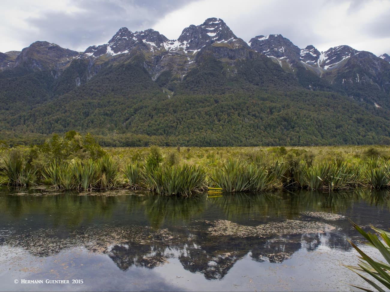
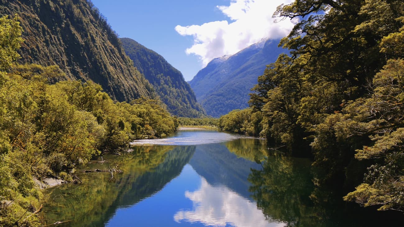
One pleasant place to stop is the Mirror Lakes. On a clear day without any wind, these lakes, which are right beside the Te Anau-Milford Highway, will show a perfect reflection of the Earl Mountains on the opposite side of the Eglington Valley.
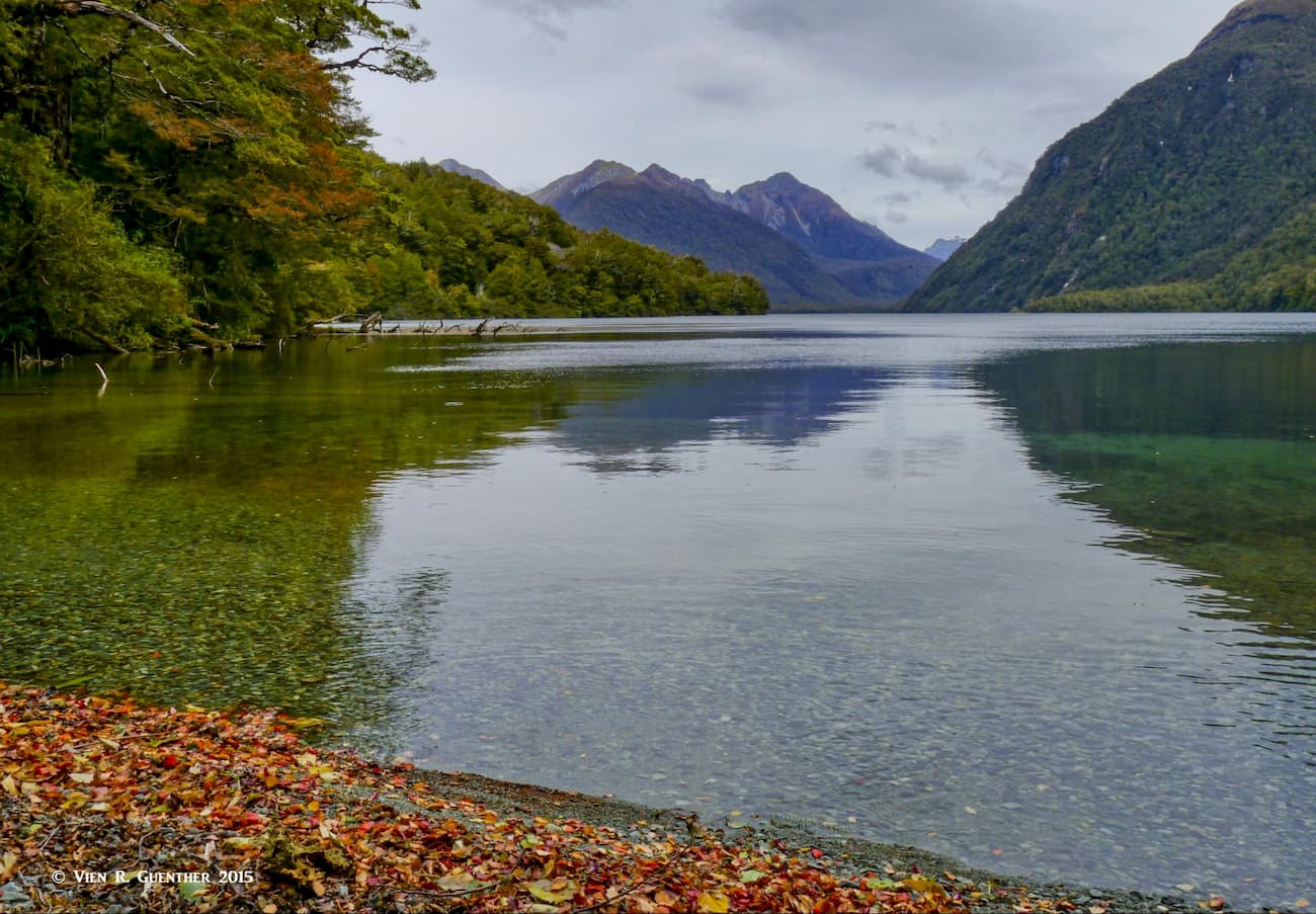
Nearby Lake Gunn, nestled at the foot of the mountains, has a campground and an easy nature walk. The tour buses don’t stop here - at least I have never seen one. When my wife took this picture, we were the only people there.
If you have plenty of time while in Milford, you can go kayaking on the sound. There you can even paddle over to Sinbad Cove from where ambitious climbers can begin their ascent of the formidable Mitre Peak, starting in the Sinbad Valley. Not for squeamish hikers.
Believe it or not, there is an airport in Milford Sound. Taking off from there, and especially landing, is not for white-knuckle flyers. But, wow, is it ever spectacular. I’ve taken a scenic flight from there once on a perfectly cloudless day (rare in Fiordland) in a small 4-seat plane. I was inspired to do that while I was on a cruise of the sound. When I saw all those planes flying low overhead, I had been unaware of the airport, so when we docked I inquired about that and found out that you can just walk to the airport from the jetty. I did and was lucky to get on a flight within minutes. Today, you would probably have to book way in advance and hope that the weather cooperates. This brings to mind one fact about Milford Sound – it is not a quiet place on a nice day. The drone of planes and helicopters goes on most of the day.
The lovely town of Te Anau is small and cannot compare with Queenstown two hours north in terms of tourist amenities, but that is what I always made my base from which to explore. Even from here, which entails a two-hour drive to Milford, it is likely that you will spend a full day, including the cruise on the sound. There is simply so much to see on the drive, and you will want to stop again and again to enjoy the splendid scenery.
But there is more to Fiordland National Park than Milford Sound, lots more, and the overwhelming majority of visitors will never see any of it. In fact, most of it is not even accessible, a wilderness like few others on earth. Although there are a number of very long hiking (tramping) routes in the park, they are few indeed given the immensity of the park. Some parts of the wilderness area don’t have any trails at all. Despite a number of easier tourist trails and some more advanced tramping tracks, Fiordland is a challenging tramping destination, and most of it is best left to highly experienced trampers. For those who really want to get into the backcountry, the only options available are off-track routes, which often follow wildlife trails. These places have so many hazards that most visitors will avoid them.
While most of Fiordland National Park is inaccessible even to experienced hikers, there are some opportunities for casual hikers and even families with children to get out into the wild and enjoy some of what the park has to offer. The remote peaks are best left to the truly adventurous mountaineers as there are no real maintained tracks to most of them. Yet the park does have many hikes and walks that are quite easy and don’t require any special experience.
But what the park is perhaps best known for are its longer tracks that typically require an entire day and are usually rated advanced and even expert levels of difficulties. And then there are those that require even three to five days to complete. These require a considerable level of fitness, experience and proper gear. Let’s look at some of the better known tracks as well as some not so well known ones.
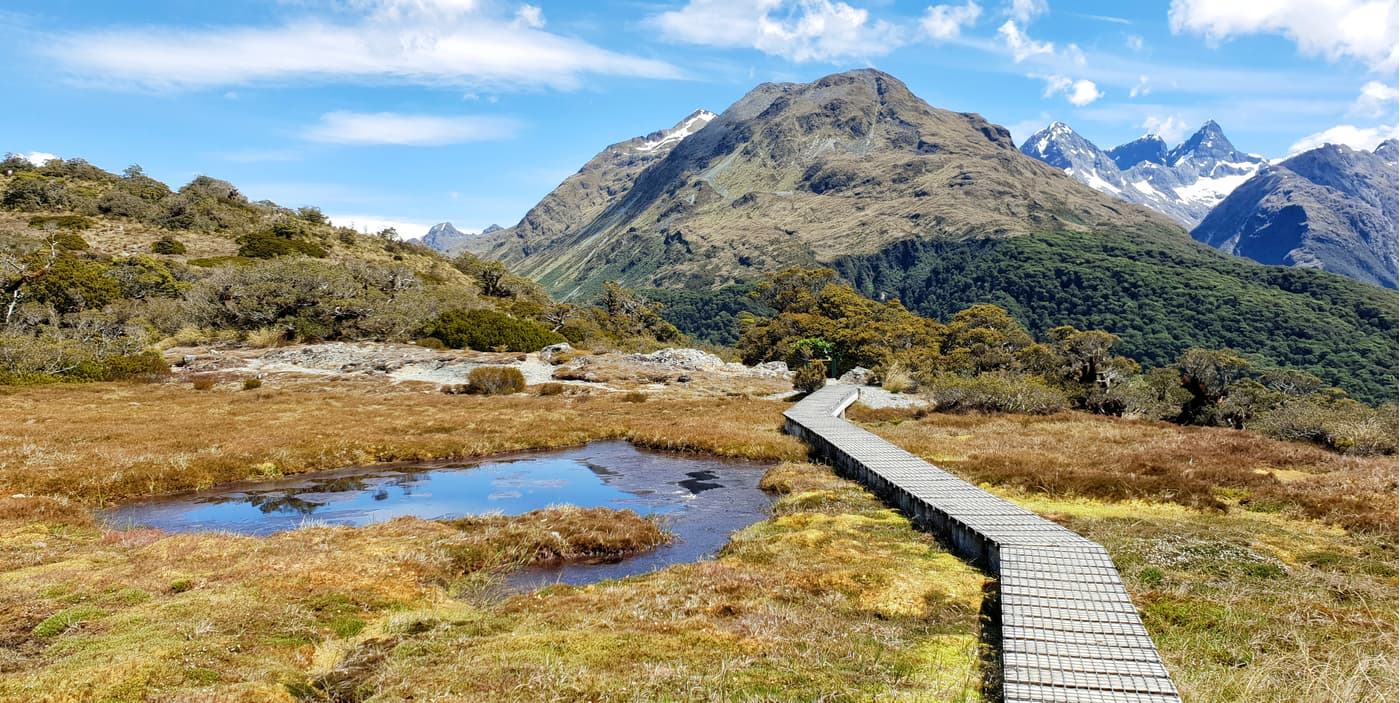
Why not start with the best-known of them all – the Milford Track. This is the one that many people will do just for bragging rights – perhaps because it has been labeled as “the finest walk in the world”. Not having done it, I cannot vouch for that description, but there must be some basis for calling it that. It is a four-day trek that is 53.5 kilometers (33 miles) and is rated as intermediate. It is designated as one of New Zealand’s “Great Walks”, which means that it is of a higher standard than other tracks. These tracks are quite wide and are surfaced with gravel, rock or dirt. Rivers and waterways are crossed by sturdy bridges. To get to and from the track you must take a boat – there is no other way. And you can only walk the track one way – from south to north, at least during the peak season. The track starts at the north end of Lake Te Anau and ends at Milford Sound. (Note that in February 2020, the northern half of the track had to be closed due to severe storm damage. The Department of Conservation therefore temporarily made the southern half available for two-way hiking.)
Along the way you will stay in a series of three huts, which must be pre-booked in the peak season, since camping is not permitted along the entire track. The huts have bunks with mattresses, untreated running water (cold only and no showers), flush toilets, heating, cooking facilities with fuel, but no utensils. You need to bring your own bedding (sleeping bags, and be sure you have a way of keeping them dry since you may be walking in lots of rain). But the views along the track are stunning, especially at McKinnon Pass, the highest point of the track, most of which lies in lowland river valleys. The climb to the pass can be quite strenuous, and if the weather is bad, unpleasant. Below the pass is a side track to the magnificent Sutherland Falls, long thought to be the tallest in the southern hemisphere.
The Routeburn Track is considered the ultimate alpine experience, even though its difficulty is rated only as intermediate. At 33 kilometers (20 miles), it is one of New Zealand's “Great Walks” and typically takes from two to four days. The track can be walked in either direction and links Fiordland and Mount Aspiring National Parks. One end of the track is near Glenorchy at the northern end of Lake Wakatipu, 68 kilometers (42 miles) from Queenstown; the other end is at The Divide, the high point on the Te Anau-Milford Road, 85 kilometers (53 miles) from Te Anau. While there are four huts along the track, a typical traverse of the track will take three days with two nights at different huts. But some trampers may simply prefer to hike to one of the huts, spend a night and then return the way they came. For those wanting to hike the entire track, it should be noted that the road distance between the two endpoints is 325 kilometers (202 miles), so you will need to arrange transportation at each end. Camping along the track is not permitted except at designated campsites.
Not having any alpine sections, the 56-kilometer (35 miles) Hollyford track is the only track in Fiordland National Park that can be walked year-round since it is rarely cut off by snow. The track can be completed in four to five days, but some prefer to stretch it out to as many as eight days. There are six backcountry huts spread out along the track so that there are good overnight options. All huts are on a first come basis year round, so no reservations are possible. Camping near the huts is permitted. Most of the huts are small and none have cooking facilities so that portable stoves need to be carried for cooking. But the huts are heated.
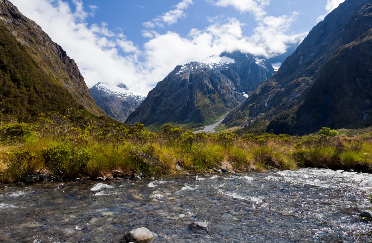
The track begins at the end of the Lower Hollyford Road, which turns off the Te Anau-Milford Highway (SH-94) shortly after The Divide. It follows the Hollyford Valley until it ends at sea level at the old port of Martins Bay, an old Māori settlement between 1650 and 1800. The track is rated as an advanced tramping track, the middle part of it maintained to a lower standard than the rest of it. It can be muddy, rocky and wet. Most river crossings use three-wire swing bridges. Parts of the track afford some fine views towards the high mountains, including Mount Madeline and Mount Tūtoko, the highest mountain in Fiordland. Much of the track follows the eastern shore of Lake McKerrow.
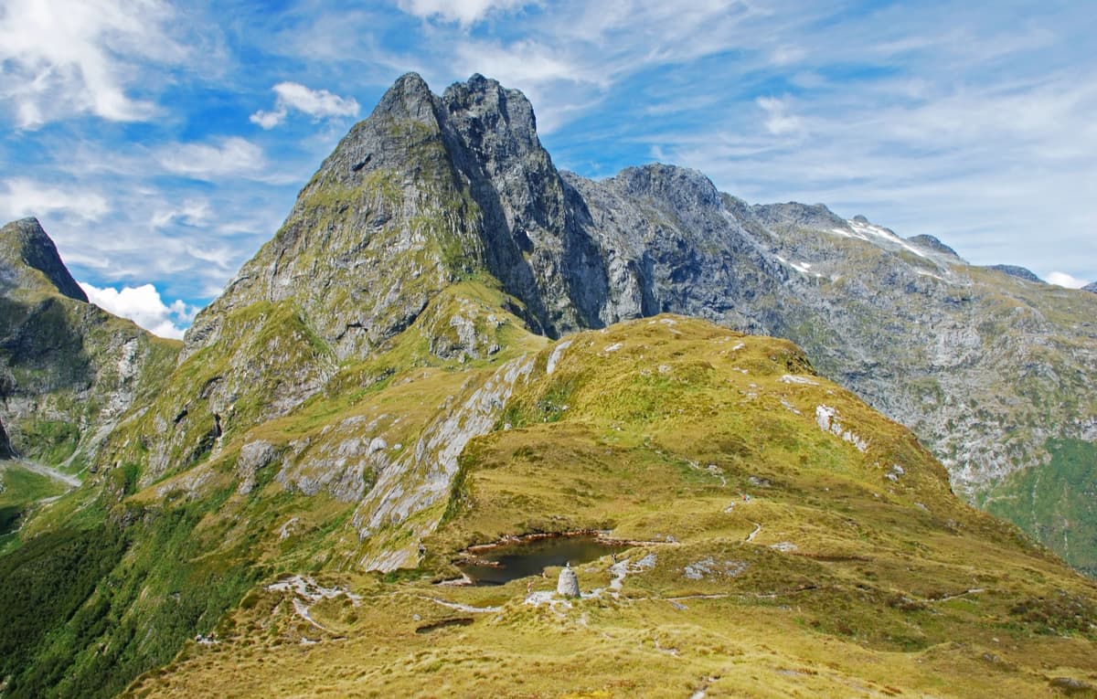
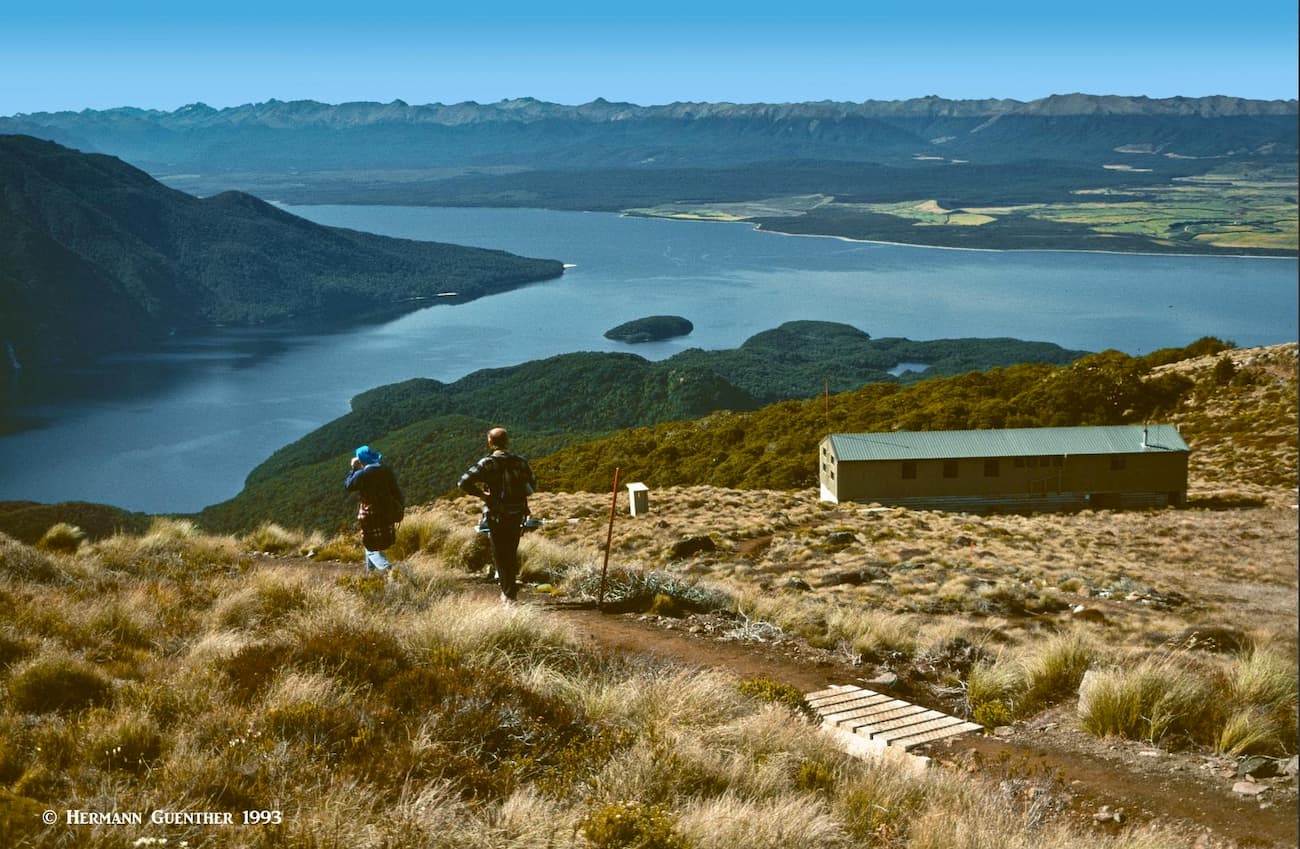
The Kepler Track is the only circular track in Fiordland National Park (apart from short nature walks) and it may be walked in either direction. It is 60 kilometers (37 miles) long and is one of the “Great Walks'' of New Zealand. Along the track there are three huts and two campsites, for which advance bookings are required. The huts have plenty of bunks, have running cold water, flush toilets, are heated and gas cook stoves are provided in the peak season. This is a magnificent track with great views, especially once you are above the bush-line, which down here is only at around 1,000 meters (3,300 feet). The view down to Lake Te Anau from the top of Mount Luxmore is stunning as is the view across the mountains of Southland. Parts of the track will also afford fine views down to Lake Manapouri.
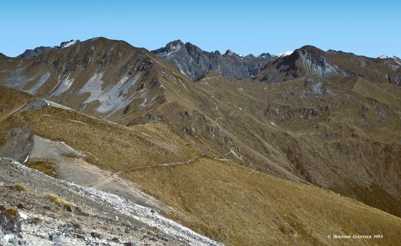
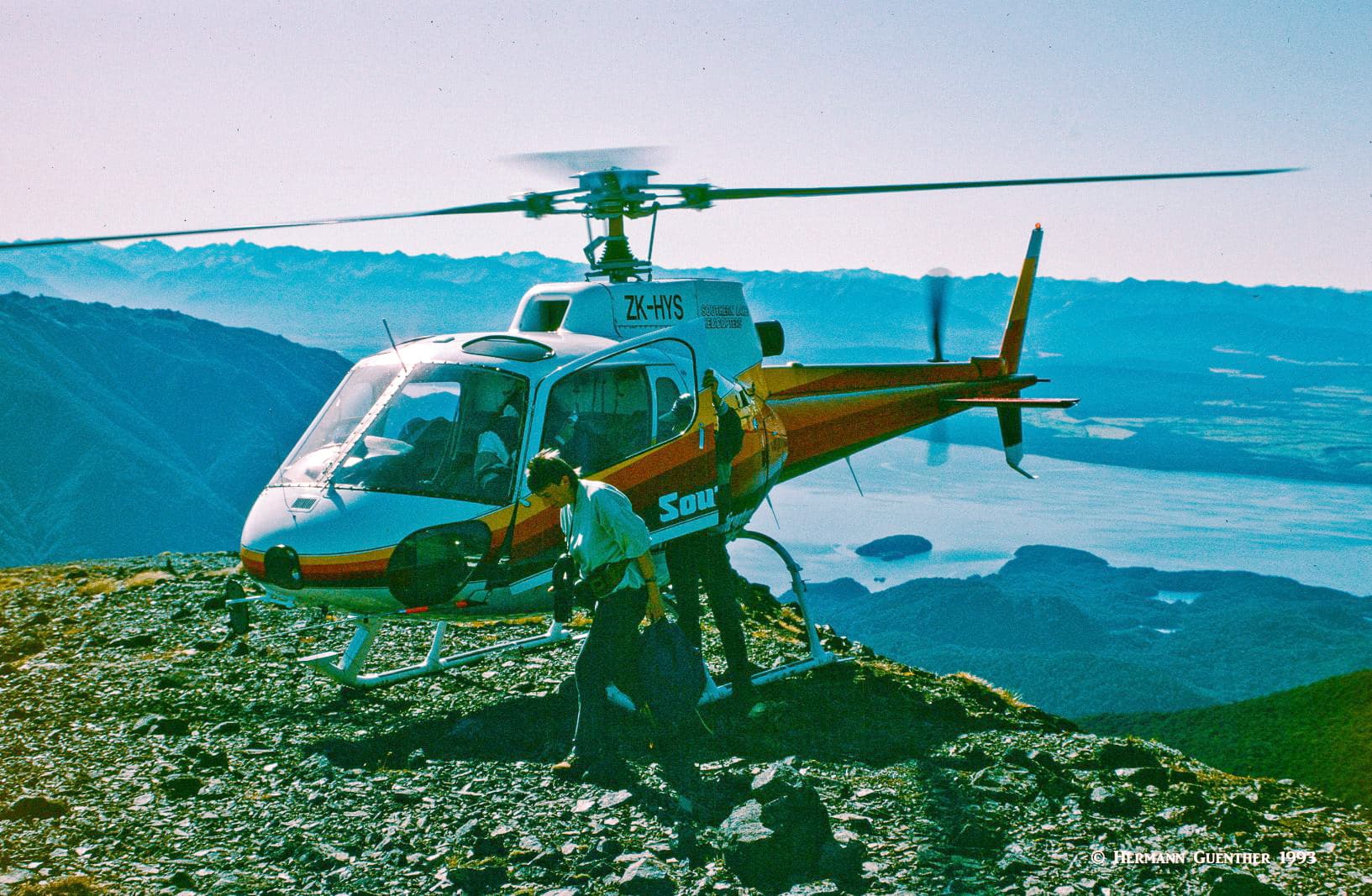
If you are somewhat limited on time but want to experience part of the Kepler, do what I did. You catch a ride on a helicopter from the lake shore in Te Anau. It then delivers you to the summit of Mount Luxmore, which is the high point of the entire track. Then you hike down the track, passing by the Luxmore Hut, and then all the way down to the Brod Bay Shelter on the far shore of Lake Te Anau, where you will get picked up by a motor taxi to take you back to town. Or you have the option of walking along the shore to the trailhead, and then on into town, but that adds about 10 kilometers (six miles) to the hike. I chose to take the boat – after all, that was included in the package, which they call the “Triple Buzz Helihike”. Do be aware, however, that there is a considerable elevation loss of about 1,300 meters (4,270feet), but at least it is all downhill. A fun experience as long as your knees hold out.
But I must qualify what I have experienced on that trip. I said that we landed on the summit of Mount Luxmore, which was correct. That was so much fun that I did it again on a subsequent trip seven years later, but was disappointed that the pilot only took us as far as a landing pad beside the Luxmore Hut, which is still far below the summit and its extraordinary views. That meant it would take a significant hike to get up there (another three kilometers - two miles; 420 meters – 1,380 feet elevation difference) each way. I do not know if there is now an option to land at the top. But either way, it is a different experience worth having.
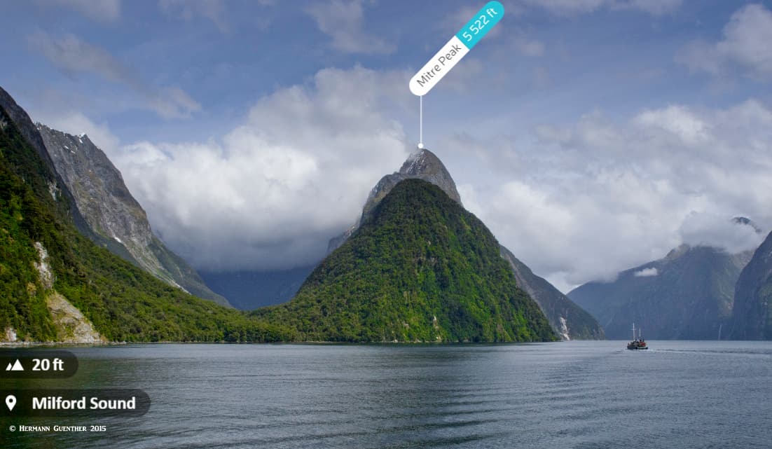
I can’t image how Mitre Peak (“Rahotu”) would not seduce you into climbing it – that is if you have the nerve, are not intimidated by extreme exposure, don’t mind bashing the bush in the lower reaches, and can be assured of a window of good weather for a couple of days. This latter factor is a strike against you, since it rains at least 200 days a year in Milford Sound. Let’s look at the reality of it. Mitre Peak, probably one of the most photographed mountains in the world, certainly in New Zealand, rises straight out of the sound to an elevation of 1,683 meters (5,522 feet). That is more than a mile of elevation gain, half of which has to be done in thick bush. It is not frequently climbed.
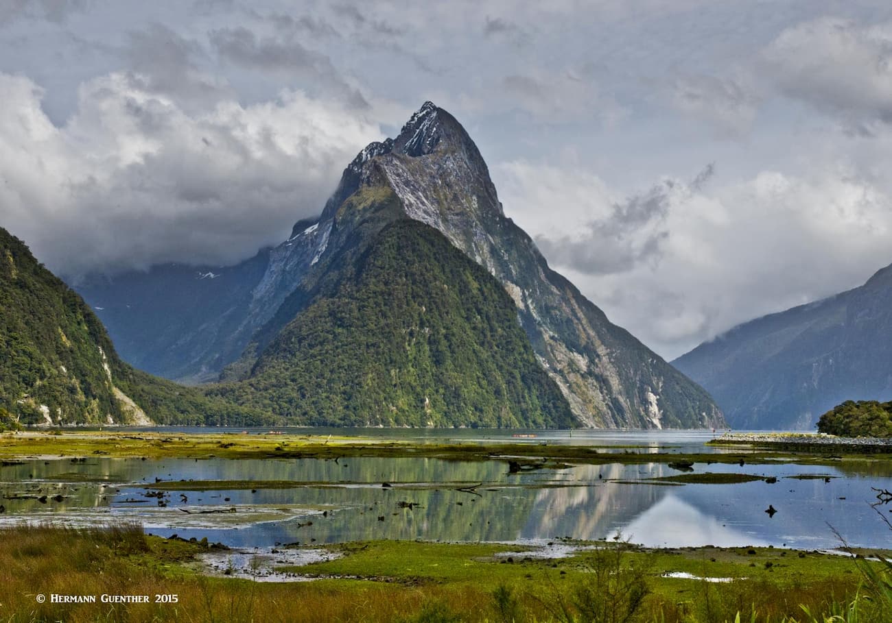
There is no marked track and you will be sure to stray off the route. But once on the main ridge, the rest of the route is “obvious”. It is not a technical climb. But the exposure is so extreme that roping up is highly recommended in some of the hairier parts. Many people don’t make it to the actual summit – some are overwhelmed by the exposure, others get so exhausted or run out of water, and some simply are not properly equipped or experienced. “Run out of water?” you ask. In one of the rainiest places on the planet? Well, there are no streams on a knife-edge ridge. And if it is raining, you shouldn’t be up there in the first place. I recommend that you read the following blogs if you are seriously considering doing this climb. Even if you are not, they are excellent reading and clearly demonstrate how intense a climb of Mitre Peak can be. The video embedded in the third blog is especially revealing. Watching that is enough to give me vertigo.
http://andrewlarson.blogspot.com/2010/01/climbing-mitre-peak.html
http://www.backpackingmatt.com/climbing-mitre-peak-new-zealand/
https://www.wildkiwiadventurer.com/mitre-peak/?v=7516fd43adaa
Let’s start with the simple fact that there are no major towns near, let along in, Fiordland National Park. By major, we are usually talking about something much larger than the best positioned town of Te Anau with a population of only 1,911. Even Queenstown, which is a major resort town 172 kilometers (107 miles) further north, has a population of only 15,650 inhabitants. But at least it has an international airport and lots of amenities. That is where many tourists to the area make their base. But if time is limited, then there are places to stay much closer that are reasonably convenient.
Queenstown is often called the “adventure capital of the world” and for good reason. For one thing, it is a major ski resort of the South Island. Its setting on the shore of LakeWakatipu, surrounded by spectacular mountains, is hard to beat. There are endless opportunities for recreation in and near Queenstown, including such activities as bungy jumping (invented here) and jet boating. This is the place where adrenalin junkies gravitate. Try to think of any adventure activities and you can find them here. And even more. Just the approach into the airport on a clear day is considered one of the most scenic in the world. Many might consider it a white-knuckle approach – I probably would on an overcast day when you are making an instrument approach through the clouds, between the mountains and you know what is out there but you cannot see it.
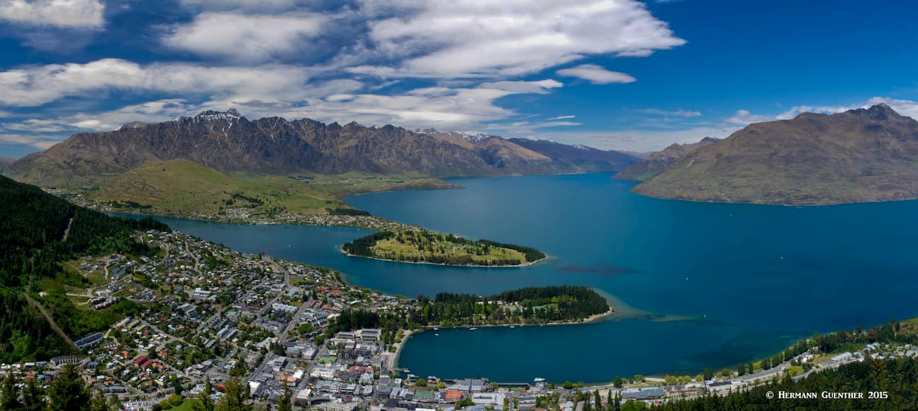
I have been in Queenstown several times and never tire of it, despite the fact that it is very touristy. But I have always gone there in the “off” seasons, not during the peak tourist invasions of winter and summer. The town is simply so charming and beautiful that one can easily deal with its popularity. In addition to the many activities you can find here, there is an outstanding selection of accommodations, restaurants and shopping venues. But Queenstown’s convenience as a base for exploring Fiordland National Park is somewhat compromised by its distance from it. But that does not deter many visitors from making 14-hour day trips from here to visit Milford Sound, for example. Now, if that is your only place you want to visit, you can fly there from Queenstown and back, but that will be sure to stretch some visitors’ budgets, not to mention the weather implications.
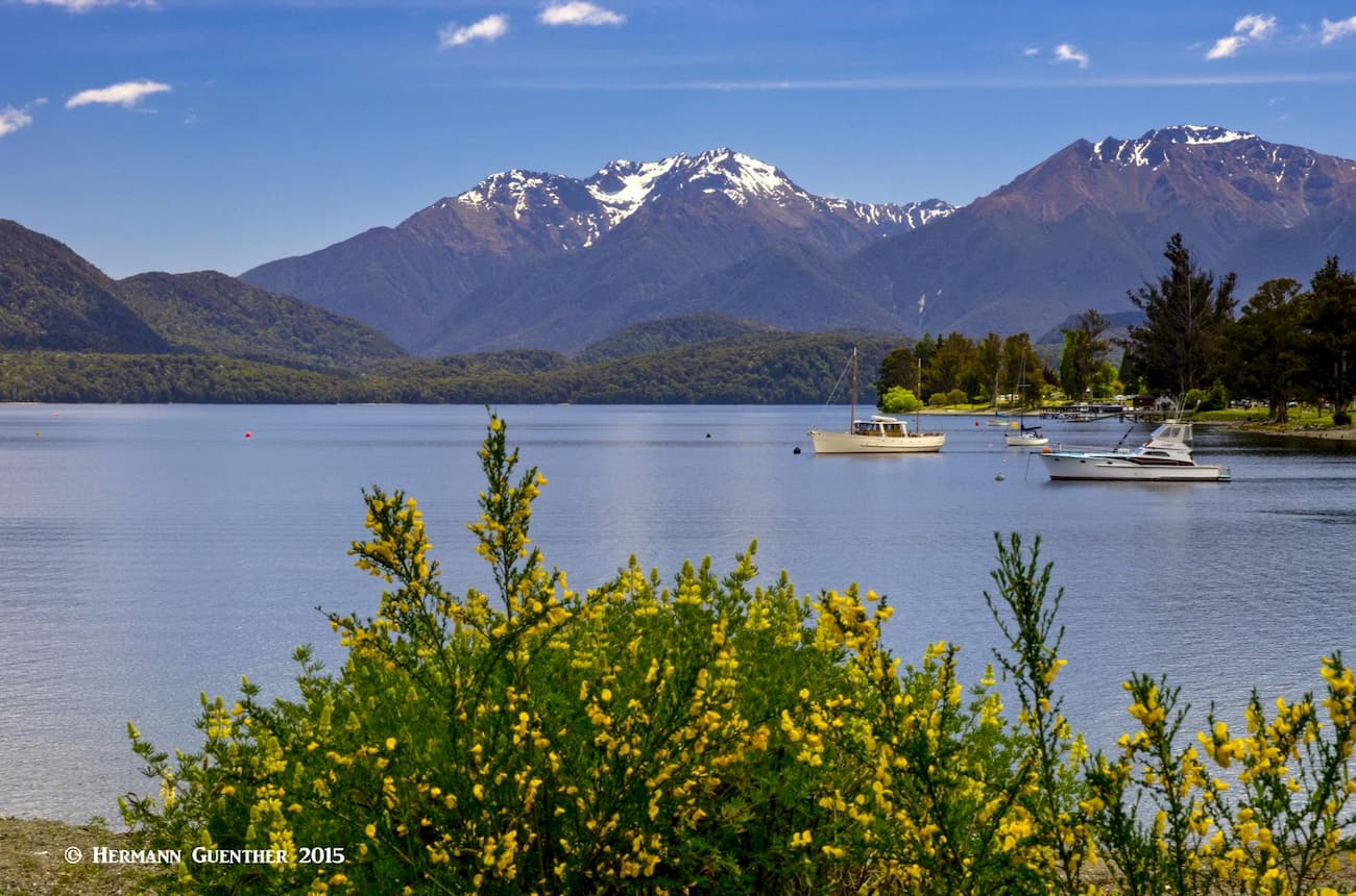
Not nearly as cosmopolitan and glitzy as Queenstown, Te Anau is hands-down my choice of places to stay when exploring Fiordland National Park. This is certainly a small town, yet it has over 4,000 beds available in the summer. I have stayed several times in the very pleasant Top 10 Holiday Park right near the center of town, which is very convenient if you have a rental campervan. But there are plenty of other places to stay at reasonable prices, plus all the other basic amenities you could want for several days. The famous Kepler Track starts within walking distance of the town center and Milford Sound is an exciting and extremely scenic two-hour drive north of the town. Te Anau also offers beautiful walks along the waterfront of Lake Te Anau, the largest lake on South Island and the second largest in the country after Lake Taupō. A short cruise across the lake takes you to the Te Anau Glowworm Caves.
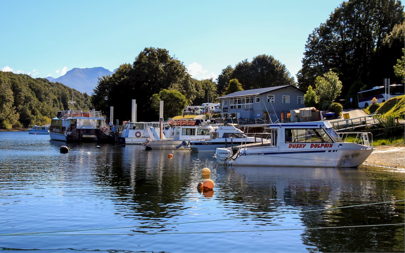
The even smaller town of Manapouri, about 20 minutes from Te Anau, is a popular tourist destination, especially in summer. It is the westernmost municipality in New Zealand and serves as the gateway to Doubtful Sound as well as the less often visited Dusky Sound. It is also the starting point for many walking tracks. With a population of only 228 inhabitants, Manapouri is obviously not a thriving metropolis, but it does offer some limited accommodations and restaurants. It also has a couple of motor camps (holiday park, caravan park, etc.). If a small, quiet town is what you prefer, you will do well to stay here, keeping in mind that one of the main attractions is Lake Manapouri and the boat cruises that start here, especially the all-day Doubtful Sound tour. This little town is totally geared toward Fiordland adventure.