Scan the QR code and open PeakVisor on your phone
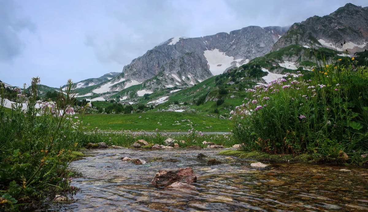
The full name of the reserve is the Caucasus State Natural Biosphere Reserve named after Kh. G. Shaposhnikov. It is the largest and the oldest protected natural area in the Northern Caucasus. It is located within three regions of the Russian Federation - the Krasnodar Region, the Republic of Adygeya and the Karachay-Cherkess Republic. It is the second-largest mountain forest reserve in Europe with a total area of 280 thousand hectares.
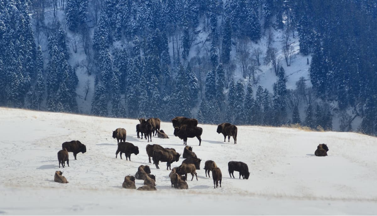
The reserve was created on the premises of the hunting lands that belonged to the former grand ducal family, aka the Russian tsars. The purpose was to preserve the shrinking population of Caucasian bison, since then the bison has become a symbol of the reserve and luckily has grown in numbers.
The Reserve is internationally recognized as a reference model of an area featuring virgin natural environments that have preserved pristine landscapes with unique flora and fauna. On February 19, 1979, by the decision of UNESCO, the Reserve was granted the status of a biosphere reserve. In 1999, the territory of the Caucasus State Natural Biosphere Reserve together with the territory of the Krasnodar region and the Republic of Adygeya was included in the World Heritage List under the name the Western Caucasus.
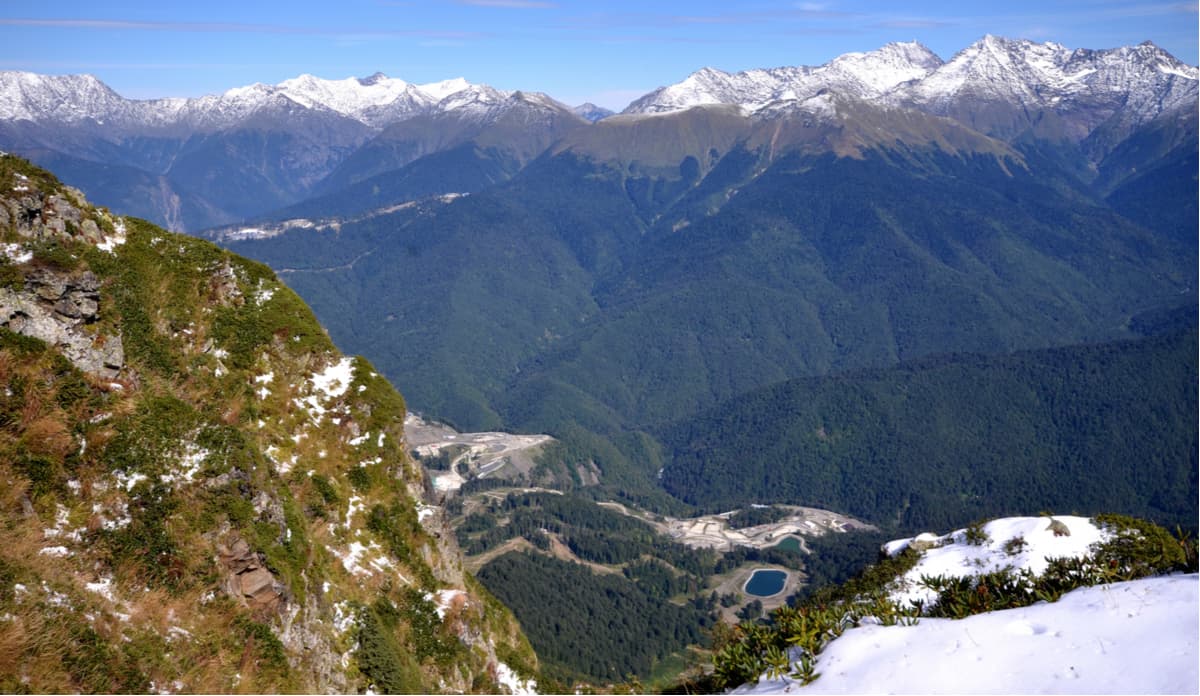
The Reserve has a special subtropical department located in the Khostinsky district of Sochi. It is a world-famous yew-boxwood grove with an area of 302 ha. The grove is surrounded by a conservation area, numerous wildlife sanctuaries, and natural landmarks, and the Sochi National Park adjoins its southern border. The Reserve is an open-air laboratory carrying out extensive scientific research and environmental monitoring. The territory of the Reserve features mountain and highland ecosystems with an absolute elevation from 640 m to 3346 m. There are over 124 named mountains, the highest is Tsakhvoa (3,345m).
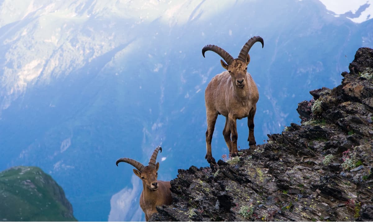
With a ban to extensive human activities, the Reserve is a safe haven for a huge number of animals. They freely roam the slopes of large mountains, subalpine meadows and green valleys. The number of species living in the Reserve exceeds 15000. According to the 2017 data, 1700 Caucasian red deer (aka royal stag), 1300 chamois, 3200 tours and 600 bears live in the reserve. There are 248 species of birds and 89 species of mammals. Other classes are represented as well – there are numerous reptiles, amphibians, insects, shellfish, as well as 33 species of fish.
Bison is surely the special pride of the reserve. It is the heaviest and largest mammal on the European continent and the last representative of wild bulls. The mountain bison is a genetic line of bison restored in the North-Western Caucasus in the second half of the 20th century. The scientists had to cross-breed the leftover of the once-mighty bison population with bison hybrids. To tell the truth, there was only one wild bison left on the planet when the project started and this bison alone generated so many offspring that now 1000 bison live on the mountain slopes. Speak of the bull virility! This is a success story recently repeated by a Galapagos giant tortoise who helped to save its species.
The employees of the Reserve are also involved in the restoration of the Persian leopard in the Caucasus. This programme was developed by the Russian Academy of Sciences in cooperation with WWF Russia. There are currently being built five centres of leopard reproduction in the Russian Caucasus in Krasnodar, Adygeya, Ossetia, and Dagestan. They will be linked into a single eco-corridor so that the population of these predators can successfully reproduce itself over time.
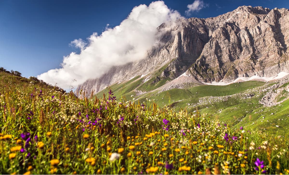
The flora of the Western Caucasus is rich in more than 2200 species of plants. Over 900 species grow in forests, 165 of which are trees and shrubs. There are 195 species of relict plants. In some areas, there are truly unique plants – thousand-year-old yews, alpine flowers, huge ferns. Here grow more than 30 species of orchids, 40 species of ferns, there are wintergreen and evergreen plants, many ornamental plants.
One of the most visited places of the Reserve is the Yew-Boxwood Grove which is located separately in the city of Sochi. This relict forest covers 300 hectares and has 400+ species of unique plants, including remnants of pre-glacial forests miraculously preserved in the only place on Earth. Across the entire territory of the natural biosphere reserve, you can spot the common yew – an evergreen coniferous plant capable of surviving 2000 or even 2500 years. Here, in the Khostinsky section of the Reserve, there are Colchian holly berry (Ilex colchica) and Carian figs, Colchian boxwood and Colchian leptopus (Leptopus colchicus) as well as many other ancient representatives of flora. Most of them are the Red Book plants.
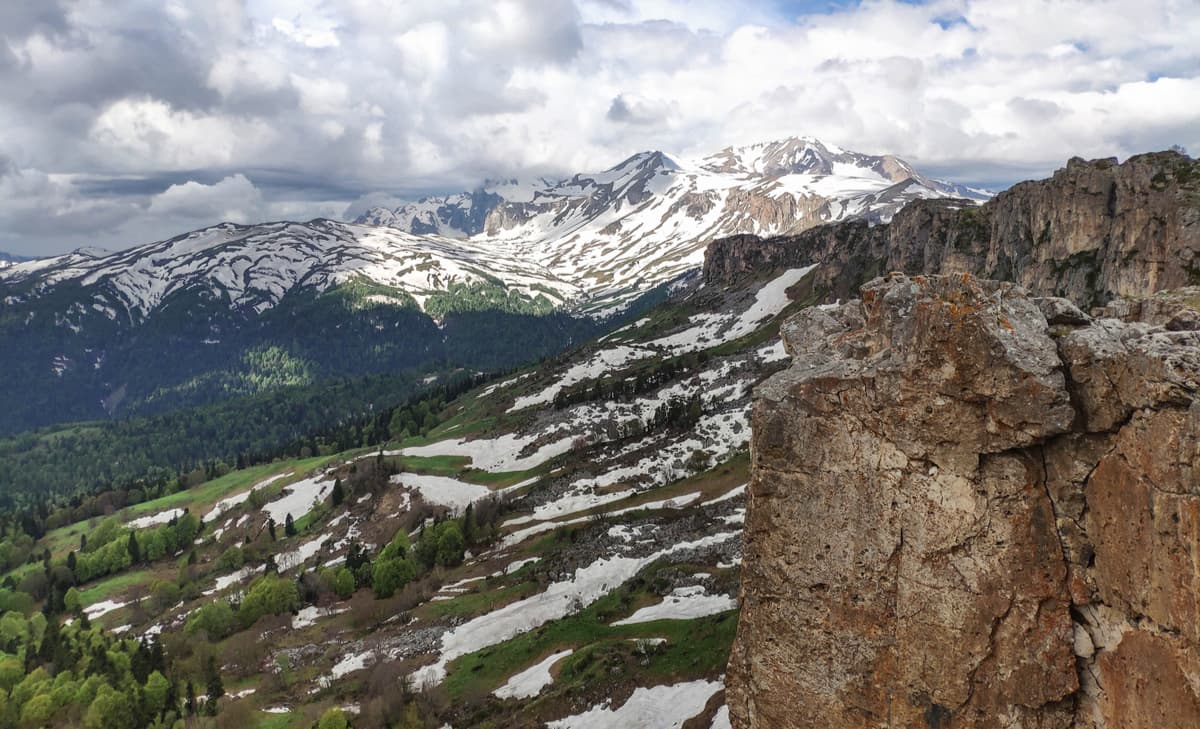
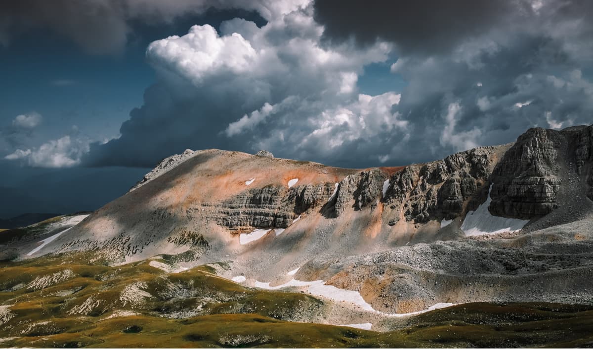
The area of the Reserve has a complex geological structure. In its axial part, the oldest crystalline rocks come to the surface and they are bordered by later limestone, sandstone, and clay shale. Some areas of the Reserve (the Lagonak Highland, mountains Fisht, Oshten, Pshekho-Su, Acheshbok, Tru, Akhun, etc.) are karst landscapes with an astounding number of caves. Just imagine, there are 130 caves in the Lagonak Highland alone. Glaciers are not a rarity in the reserve. In total, they are about 60, and the total area is 18.2 square kilometres. The largest glacier covers Pseashkho Mountain and is 1.5 sq.km.
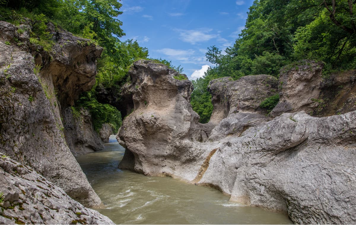
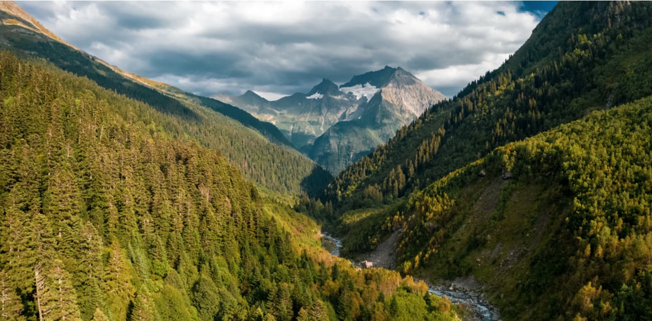
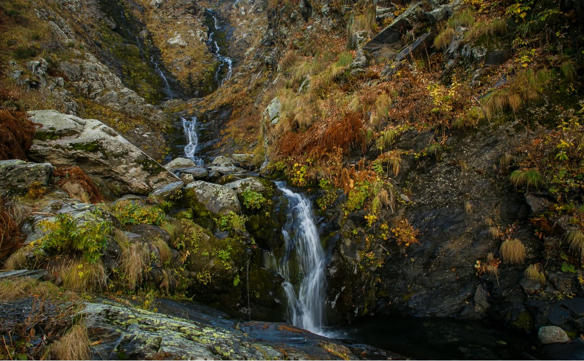
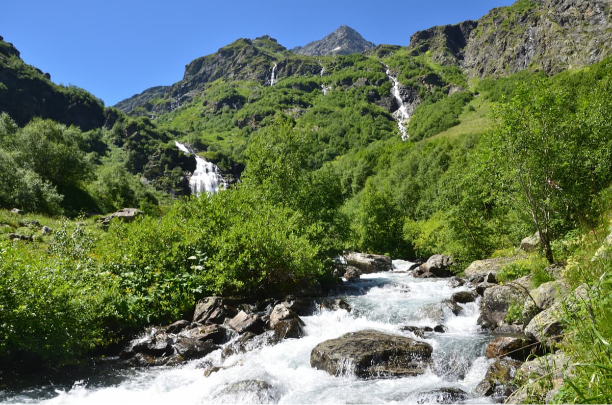
Fast rivers and azure-blue lakes take up about 2% of the Reserve's territory. On the southern macro-slope of the Greater Caucasus Range, there are rivers the Mzymta with its tributaries Chvizhepse, Laura, Achipse, Pslukh, Tikhaya, etc., the Khosta, the Sochi, and Shakhe with its tributaries Bzych, Azhu, Bushchy, etc.. The northern macro-slope features the river Belaya (White) with the Ches-su, Kisha, Pshekha and other tributaries, the Malaya Laba with the Tsakhvoa and Urushten tributaries, and the Zakan and Damkhurts rivers belonging to the Big Laba basin. The rivers running down the northern macro-slope are tributaries of the Kuban River. The rivers are typical mountain streams with plenty of rapids and waterfalls, narrow rocky gorges, ravines, and canyons.
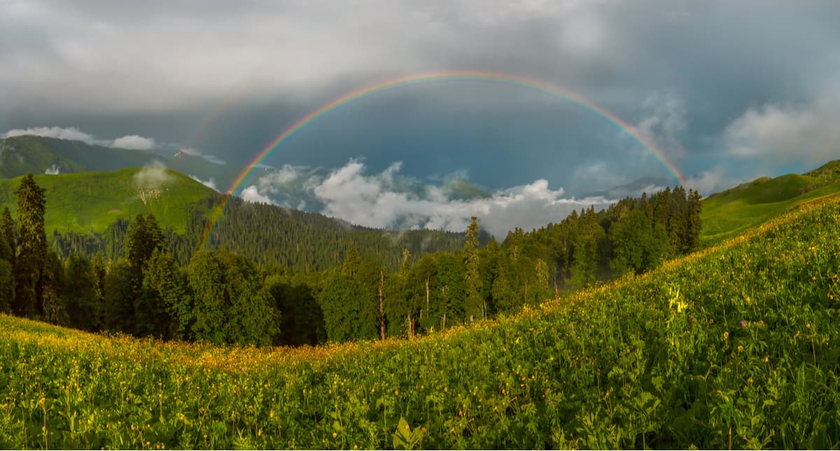
The lakes are numerous and offer great opportunities for outdoor leisure and photography. Currently, only about 240 lakes have been identified and recorded within the Reserve. Their diversity is amazing: there are both huge reservoirs whose shores stretch many kilometres, and a scatter of tiny blue pools, too small to have their own names. The colours of the water are staggering and would please even the most fastidious instablogger. Take your best shots of turquoise, green, azure, cobalt, ultramarine and greyish steel lakes that will please you in any weather. However, most of the year the lakes are almost inaccessible due to not only the adverse weather conditions but also thickets and rough rocks blocking the trails, so only big bisons and chamois can stare in the serenity of those natural ponds. To add to the enigma, the number of mountain lakes, their shape and size are not constant. As glaciers melt, new lakes form, rivers and avalanches change the shape of their banks, old lakes come to the end of their life cycle, turning into swamps.
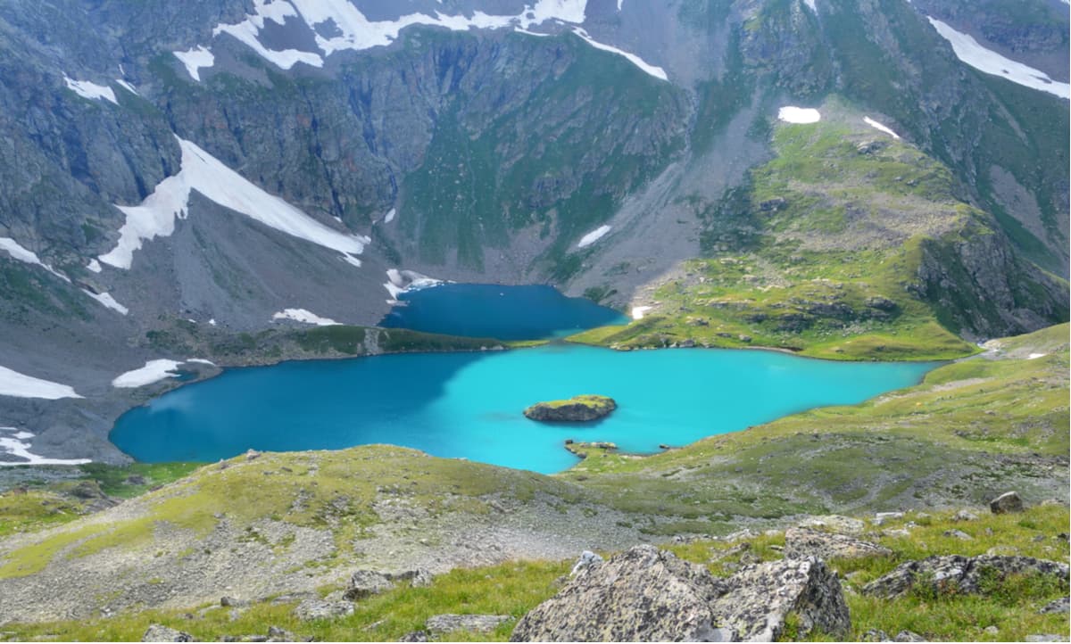
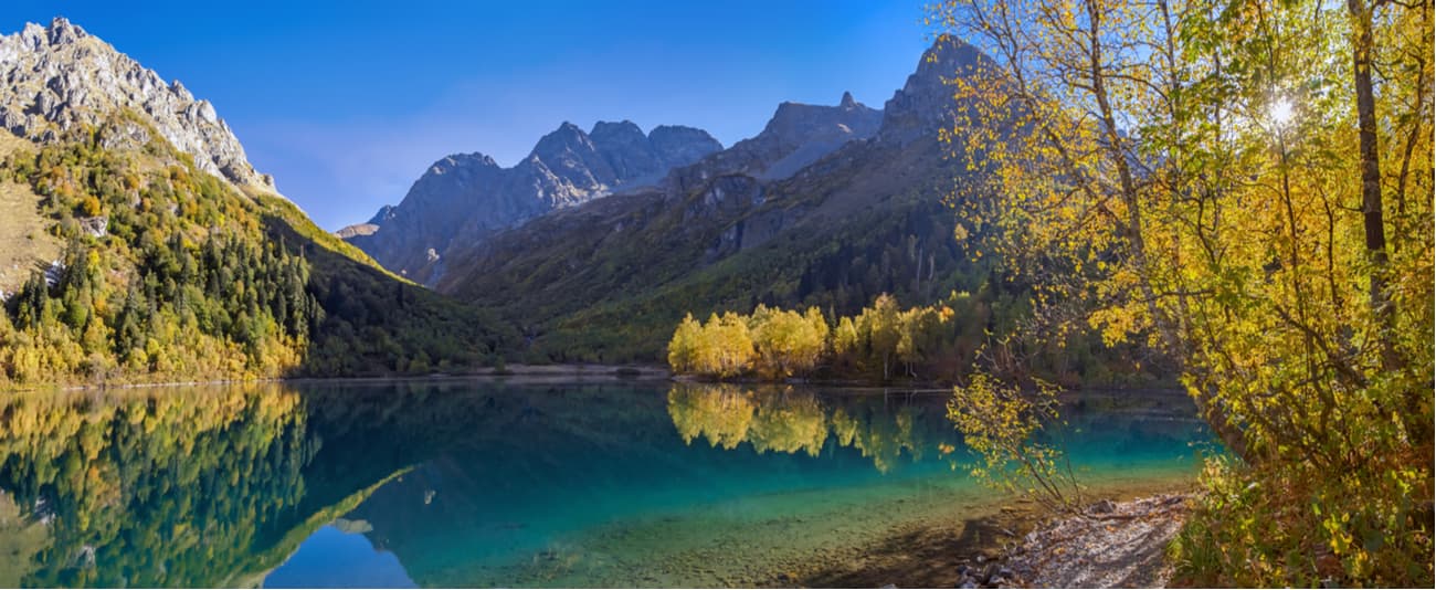
The lakes of the reserve are relatively small in size and often are completely free of ice only by mid-summer. The largest lake of the Reserve is Lake Silence (Bezmolvia) with a water face area of 200,000 sq.m. It lies at an altitude of 2, 530 meters above sea level. The name Silence did not appear at random. There is an amazing silence around it, uninterrupted by the bubbling noise of the rapid rivers. The largest damming lake is Kardyvach (1,850 m) from which the Mzymta River originates. Lake Khuko (1,843 m) on the Greater Caucasus Range, the Inpsi in the upper reaches of the Tsakhvoa River, the Blue and the Atzetuk lakes are particularly beautiful and popular.
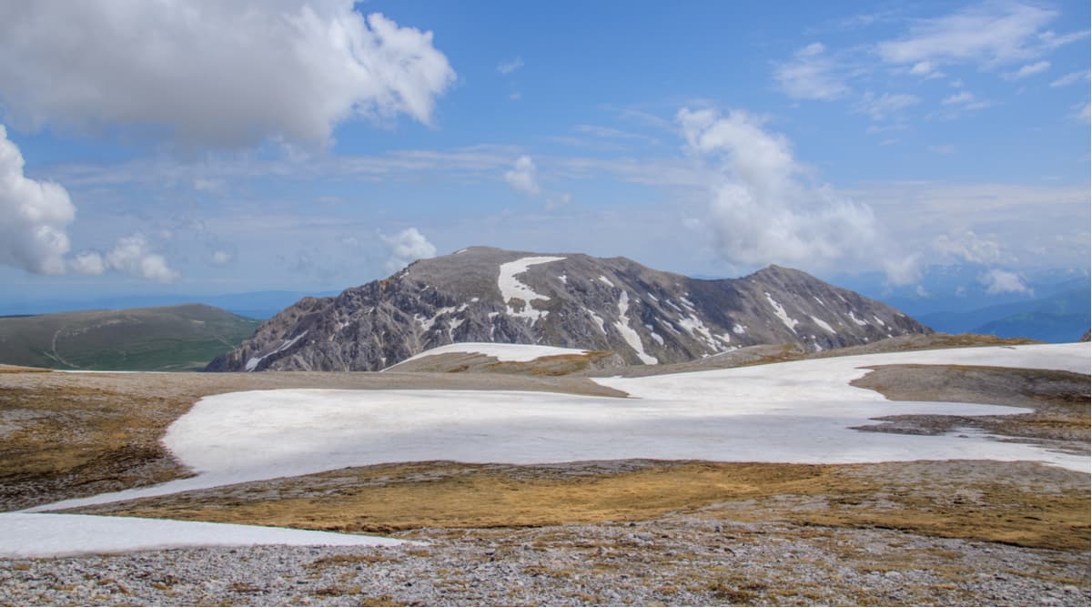
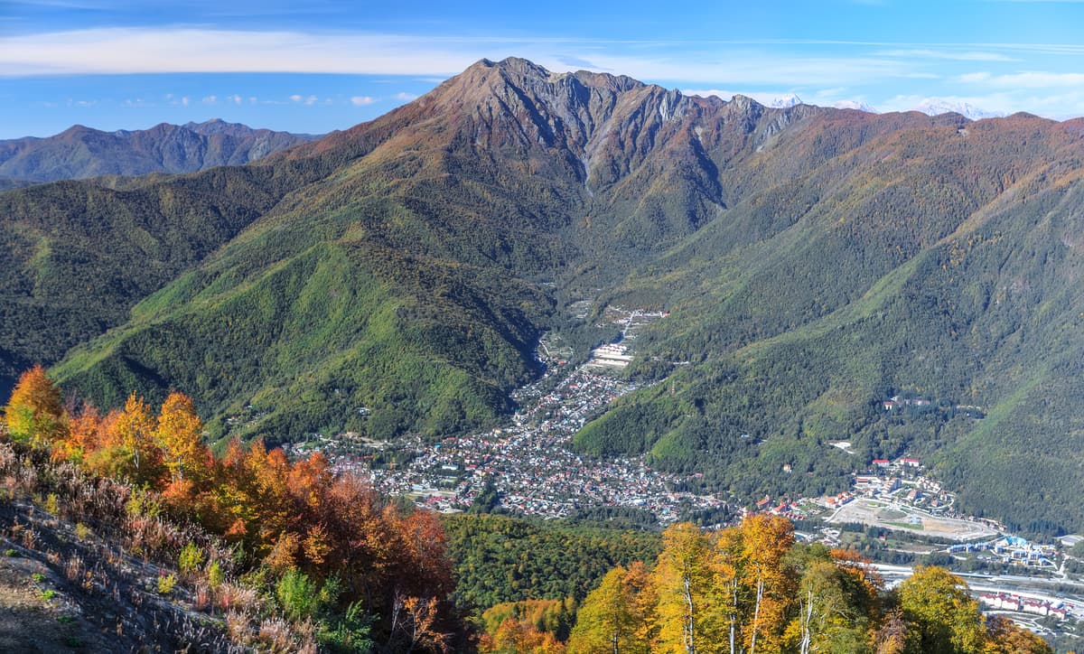
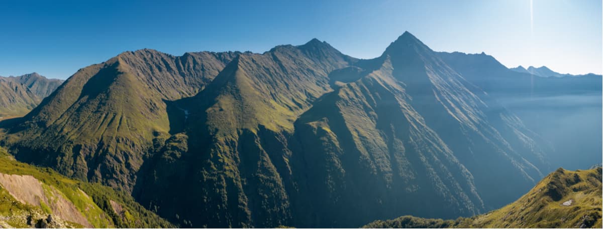
The main ridge (Greater Caucasus Range) can be traced quite clearly from the town of Fisht (2,867 m) in the west to the town of Adzhara (2,935 m) in the east. It divides into northern, wider and southern macro-slopes. The outpost of alpine relief and modern glaciation in the western part of the Greater Caucasus Range is the Fisht-Oshten Massif, Mount Fisht (2,867 m), Mount Oshten (2,804 m) and Pshekho-Su (2,743 m). The main peaks of the Greater Caucasus Range are Chugush (3,238 m), Urushten (3,020 m), Northern Pseashkho (3,257 m), Tsakhvoa (3,345 m). The Lateral Ridge is located to the north of Greater Range at a distance of 2-25 km, the main peaks are Tybga (3,065 m), Chelipsi (3,097 m), Damkhurts (3,193 m).
The Reserve partially covers the Southern Front Range as well, which is located south of the Greater Caucasus Range and stretches parallel to it from north-west to south-east. The range includes the highest point of the Greater Sochi, Mount Agepsta (3,256 m). The following peaks are also situated in the vicinity: Psegef (1,243 m), Psekhetuk (1,283 m), Stagoki (1,338), Autl (1,855 m), Bolshaya Chura (2,250 m), Achishkho (2,390 m), Aibga (2,462 m), Stone Pillar (2,509 m), Efremov Peak (3,114 m).
Tsakhvoa (3,346m) is the highest point of the Krasnodar Region. There is the largest glacier of the region located on the northern slopes of the mountain. Its total area is about 2,500 sq.m, it descends on steep rocky slopes in three narrow tongues. Mount Tsakhvoa is one of the most beautiful peaks in the Caucasus. It is popular among tourists and mountaineers alike. Climbing Tsakhvoa is of 1B-2A category of difficulty by mountaineering standards. Oftentimes the groups preparing for Elbrus climbing use Tsakhvoa as a base camp to acclimatize and get into better physical shape.
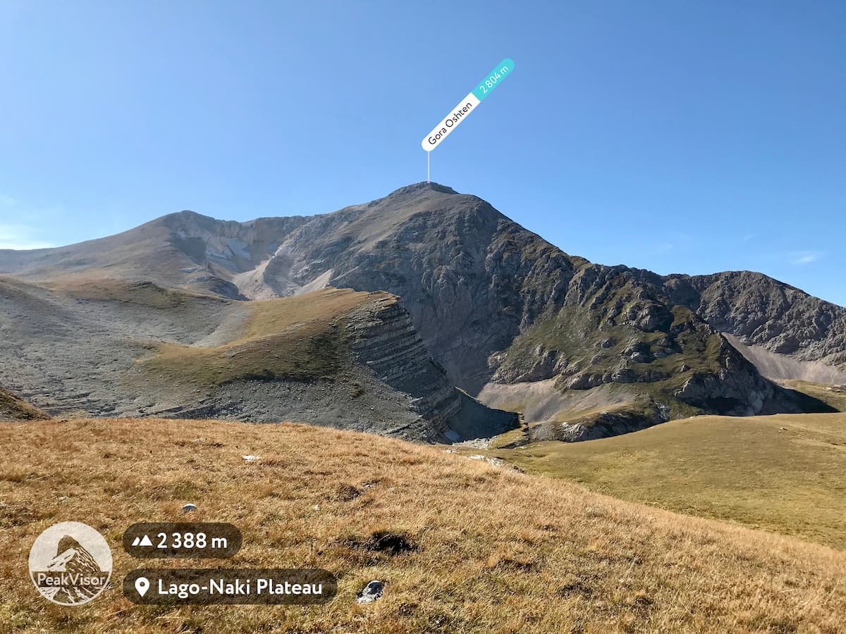
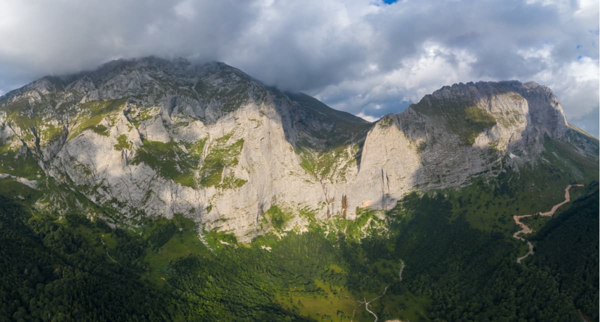
Fisht aka White Head (2,867 m) is a mountain peak in the western part of the Greater Caucuses Range. Fisht forms the so-called Fisht-Oshten massif together with the peaks of Oshten and Pshekho-Su. The peaks of the massif represent the first (moving from west to east) peaks of the alpine type in the Caucasus, i.e. rising significantly above the upper boundary of the forest with a wide belt of subalpine and alpine mountain meadows. In addition, Fisht is the westernmost peak in the Caucasus with glaciers on its slopes (Big and Small Fisht glaciers) and significant rock discharges. Oshten, Pshekho-Su and Fisht form one mountain massif with three well-pronounced peaks separated from each other by a saddle lying in a southeast direction. Oshten together with Fisht are also the first peaks from the western end of the Caucasus Range rising to the height of the snow line and covered not only with snow but also with small glaciers (there are about 10 glaciers shared by those two).
Unlike its big brother Mount Fisht which has become widely known for the Fisht Olympic Stadium built for the Sochi 2014 Olympic Games, Oshten aka Eternal Snow (2,804 m) is less famous but none the less spectacular. This place is considered one of the most beautiful in Adygea. The slopes of the mountain are inhabited by Caucasian chamois, or black goats as they are often called. From the top, there is a beautiful view of its neighbors – Pshekho-Su and Fisht. To the south and west, there are green mountain forests, low and narrow mountain ranges. In the north, from the top of all those three peaks, you can see the vast alpine meadows of the Lagonak Plateau, canyons of the rivers Tsitse and
Kurdzhips, the Stone Sea and Nagoy-Chuk Ranges. Climbing Oshten is very popular, to get here you need to buy a ticket at the cordon of the reserve.
Route No.30 of the Reserve features the Fisht-Oshten massif. The closest settlements are Dakhovskaya, Hamyshki and Guzeripl.
Pshekho-Su aka Princess’s Water mountain (2743 m, also sometimes spelt Pshekha-Su) is the lowest in the Fishten-Oshten area, but it is no less beautiful than its bigger brothers. On the northeastern slope of the mountain, there is a small glacier of 0.1 sq.km. in size. It is one of the three age-old Caucasian glaciers with deep, low-lying fractures. On the western side of the Massif, at the junction of Mount Fisht and Pshekho-Su, falls one of the highest waterfalls in Europe. It is also known as simply The Waterfall (or the Pshekho Waterfall). It is a symbolic boundary of two mountain peaks: Fishta and Pshekho-Su.
Hardly can you call Mount Pshekho-Su particularly famous for trekking, it is overshadowed by its neighbouring Fisht and Oshten. However, Pshekho-Su also has its own fans. After all, you can conquer this mountain even if you are not a die-hard mountaineer. It is enough to have an average level of sports training and some experience in moderate climbing.
Chugush (3,238m) lies on the border of the Krasnodar Region and the Republic of Adygeya. The name can be translated from Adygean as "the top of the earth". On the northern slopes of the mountain lie two glaciers with an area of 0.5 and 1.2 sq.km., and on the eastern slope, there is one more 0.5 sq.km glacier. Actually, there are more glaciers, they are much smaller and usually don’t have their proper names, just numbers. What should be mentioned though, regardless of the modest size, most of them are dangerous and have really tricky and deep crevices.
Chugush is a beautiful rocky peak well visible from Sochi, Akhuna and Achishkho peaks. It is usually closed for visitors, that is why if you are lucky to get a chance to climb it, you will see hundreds of Caucasian turs (European buffalos) roaming Chugush, the employees of the Reserve often leave special salt cattle lick for them. Beware though, those naughty animals climb much better than humans and have a nasty habit of stamping on the rocks so hard that you have a rockfall on your head. This is how they are trying to protect their realm and not let you pass higher. One more challenge is water. Sources are limited, but you can melt some snow (even in August!) from the snow patches and glaciers.
The Achishkho Range, or ‘the horse mountains’ as translated from Abkhazian language, in another version it is ‘goat mountains’, is a mountain range in the Western Caucasus, located in the Krasnodar Region of Russia. The major peaks of the range are Achishkho Main (2,390 m), 10 km north-west of Krasnaya Polyana; Achishkho I East (2,321.4 m), Achishkho II East (2,363.2 m), Achishkho West (2,317.7 m), and Horse Head (2,159.0 m). The range is composed of clay shale and volcanic tuffaceous stone. The landscape of the ridge is characterized by ancient glacial relief and ridge lakes including karst ones. On the slopes, there are stunning waterfalls, including the cascading Achypsinsky Falls in the upper part of the Achypsa River. The Achishkho slopes are covered with broad-leaved deciduous forests, mainly beech.
There are many fir trees in the north and mountain meadows at the tops.
The Achishkho Range is known for its unique microclimate. There used to be the permanent Achishkho weather station on the western shoulder of the range, now it is used only occasionally. The range is located in the humid climate zone – the annual precipitation amounts to 3200 mm, the highest in Russia. The thickness of the snow cap reaches 4.8 m. The number of sunny days does not exceed 60-70 days per year.
Trekking to the highest point of the massif – Achishkho Main Peak (2,390 m) - is one of the most popular routes in Krasnaya Polyana. There are also dolmens if you are interested in pagan mysteries connected with those table-stone edifices.
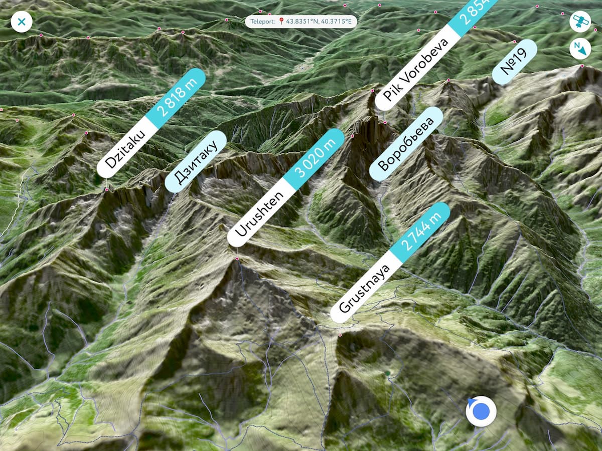
Only six passes have been described and investigated in the Urushten mountain range. All of them are difficult to pass. That's why encounters with other mountain aficionados would be quite rare, which greatly appeals to those genuinely interested in the pristine wilderness. The Urushten Ridge can be classified as one of the waterless mountain systems in the area. There are no lakes or rivers in its spurs. The highest peak is Urushten (3,020m). The height of passes here is more than 2700 meters, and one of them – Urushten North (2,930 m) – is one of the highest passes in the Krasnodar region. But the most unusual and mysterious among them is the Crystal pass.
Crystal Mountain aka Belorechenskaya (1,976m) lying between Urushten Mountain and the Aspidny Pass fully does justice to its name. In numerous caves and stone cavities, the so-called crystal cellars, travellers can find large outcrops of rock crystal. This colourless mineral, which is a kind of quartz, is a surprisingly transparent and sparkling crystal. In Soviet times, several hiking trails were laid through the mountain. Rock crystal was also used to lay a horse road used by the Circassians to travel to the Black Sea. This road was a part of the ancient Silk caravan route to the sea and later a military road. This is also a Caucasian ‘Trail of Tears’ that transported slaves in olden times and was also used by the Circassians to flee to Turkey.
Pseashkho (3,257 m) is located 20 km away from Krasnaya Polyana settlement, in the upper reaches of the rivers Urushten, Malaya Laba, Pslukh. The name literally means "a mountain with high water content", apparently due to the fact that on the slopes there are several rivers fed by glaciers. Pseashkho Mountain is the highest of the Pseashkho massif, which is a complex mountain junction with ridges of different directions and peaks starting from 2500 m. The following peaks are attributed to the range: Northern Pseashkho (3,256.9 m) – the main peak; Southern Pseashkho (3,251.2 m), Uzlovaya (3,004 m), Sakharniy (Sugar) Pseashkho aka Sugar Head (3,189 m), Western Pseashkho (2,899.8 m).
The Pseashkho massif features 11 glaciers. The largest of them, the Pseashkho glacier, is one of the largest glacier in the Krasnodar Region (evidently, not the largest glass field in the world but still an impressive ice body). The glacier is 3 km long and has an area of 1.5 sq. km. To the north of the highest peak of Northern Pseachkho, there is the Mramorny (Marble) glacier, which feeds to the River Mramornaya. Also on the northern slopes is the Kholodny (Cold) glacier, from which the Kholodnaya river originates, it then flows into the Urushten river in a few kilometres. The Pseashkho is popular among tourists and climbers. On some peaks, there are mountaineering routes of complexity categories ranging from 1B to 3B.
There are 11 officially approved routes through the territory of the Reserve with a total length of about 450 km. Those include one of the most popular Soviet tourist routes – Route No.30 to the Fisht-Oshten massif. You must obtain a permit to visit the Reserve. All routes have marked trails and equipped parking lots. The routes can take from one day up to a week to cover, depending on the length and complexity. The most popular natural attractions are Fisht, Oshten and Pshekho-Su, Khuko and Kardyvach lakes, the Aishkha Pass, the Pseashkho Massif and the Achishkho Range, and the Engelman Glades. The routes are listed on the official website: https://kavkazzapoved.ru/index.php/routes but the description is in Russian.
Climbing Bzerpi Peak (2,483m) and Mount Achishkho are the two most popular day hikes suitable for tourists of all levels. They start from the Alpika-Service rope station at Krasnaya Polyana. The cable car 3S can climb to a height of 1,660 meters from where a leisurely ascent to the alpine meadows of Bzerpi takes only 2-2.5 hours. The Bzerpi cornice (kind of a ledge rock with the ground rising on one side and falling away on the other) is about 2,100 meters above sea level. From the cornice, there is a beautiful view of the Krasnaya Polyana and majestic mountains. Then you can climb Bzerpi Peak (2,483 m). You can undertake a one-day walk, or hike for two, three or even five days. The beauty of these hikes is an opportunity to spot turs and chamois and sometimes even a Caucasian bear. Subalpine herbs fill the air with the intoxicating aroma of herbs and flowers, and busy bees fly from flower to flower collecting plenty of healing alpine honey.
The Bzerpi cornice ends in a steep cliff towards the Achipse River, hence its name. The route to the Bzerpi cornice lies over the Tabunny ridge. You can go around it along or conquer it, see alpine glades, cliffs and rocks, as well as mountain rivers.
There are several mountain chalets in the area. You can have a hearty snack on the porch with a beautiful view of the mountains, and from the top of Mount Tabunnaya, you can enjoy a beautiful panorama of the gorge of the Mzymta River, Krasnaya Polyana, Olympic facilities, ski slopes, high peaks of the Greater Caucasus Range and even, if you are lucky with the weather, enjoy a glimpse of the faraway the Black Sea.
The route follows a forest trail to the alpine zone of the Achishkho massif, it presents no technical difficulties and is accessible to almost everyone. Trekking along the picturesque alpine meadows to the Achipse waterfalls begins over the village of Krasnaya Polyana, Lake Khmelevskoye and Lake Zerkalnoe (Mirror) passing on the Achishkho Range. Lake Mirror has viewing platforms with views of Aibga (2,462 m), Chugush (3,238 m) and Assara (2,631 m). The trail runs along the eastern slope of Achishkho to the sources of the Achipse River where the Achipse waterfalls are located.
The waterfalls there are the so-called azangwaras, sometimes loosely translated as ‘the fence for the dwarves’, they are ancient stone buildings, the origin of which is controversial, but they are assumed to date back to 5000 BC. From the Achipse Falls, the path goes up to the northern circus of Achishkho. The best time to visit the waterfalls is in summer and the first half of autumn when the alpine zone is completely covered with snow and the waterfalls are full and appear before the traveller in all their glory.
The route starts from the confluence of the Bolshaya Adjara River into the Damkhurts River and goes 18 km upstream of the Karapir cordon. It winds through the valleys of the rivers Bolshaya Adjara, Mzymta through the Kvata Pass and lakes Inpsi and Kardyvach in the forest and alpine zones. On the way from Lake Kardyvach, you can admire Turya Mountain (2,716 m), and behind it opens the rocky Mount Agepsta (3,256 m) capped with eternal snows and glaciers. The Engelman glades (1450 m a.s.l on average) stretch in a narrow strip along the Mzymta River. They are lavish meadows with abundant mineral springs. Along both banks of the river, there are over 120 mineral water springs. Here the water springs from under the ground with bubbling jets.
Lake Kardyvach (1,838 m), formed as a result of the glacier movement about 3500 years ago. It is of moraine/proglacial origin and has an ellipsoidal shape. Due to the fact that the lake is hidden under the ice 7-8 months a year, even in summer, the water does not warm up above +12°C. The lake occupies an area of 133,000 sq.m., it is 450-650 meters long, 230-450 meters wide and 23 meters deep. The size depends on the season and the current precipitation. The longest river on the Russian Black Sea coast, the Mzymta (89.6 km), originates in the south-western part of the lake. Not far from the lake is the Emerald Falls.
Lake Bolshoe Imeretinskoye (aka Lake Silence) is the largest lake in the Caucasus Reserve. Its area is 198,000 sq.m. The lake is cirque/tarn and occupies a huge circus at an altitude of 2,530 meters. Despite its beauty and uniqueness, the lake has not been visited by people for a long time. It has one distinctive feature: thirty meters from the eastern shore, a massive rocky island with abrupt, steep banks rises above the transparent blue surface. The island is covered in grass which makes its reflection in the serene lake waters even more spectacular.
The route to the Zakan cordon and Imeretinsky lakes is famous for its beauty. It is one of the most popular officially permitted recreational routes in the Reserve. To get to the lake you have to overcome about 15 km and gain more than 1000 meters of elevation. Along the way, you pass by a variety of natural phenomena. Starting with a fairytale dense forest, you get into the thickets of subalpine high grasses that are so long, a human may not be seen walking in them. Then you walk through blossoming alpine meadows, and should you wish to rise above Lake Silence, you will see the grimly looking stones and blindingly white snowfields. The great advantage of the route is that it is not difficult to navigate: it runs along the Imeretinka River. Along the way, there are two very impressive waterfalls. The lower one is a cascade of 120 meters high and the upper one is 60 meters high. In July, during the high water period, the Imeretinsky waterfalls look very powerful.
Lake Silence shows up quite unexpectedly when you enter an old, grass-covered final moraine cut by the river, you will see the lake circus. The lake is unusually beautiful. It is shaped like a moon and stretches in the north-south direction. In the southwestern part, it is connected by a shallow channel to an oval bay fed by snow plumes coming down from the northern slopes of the giant circus. This kind of shallow strait can be waded through – in August the depth can hardly reach an average man’s waist. This is where Caucasian turs live. They are absolutely not afraid of people, tourists sometimes feed them. This route can continue to other lakes in the area: the Riviera, the Geografov, the Bush and the Celestial Empire. From Lake Celestial Empire (Podnebesnoe), you should definitely climb the Celestial Pass but only if the weather is decent. From there, you can see lakes Humanoids and Oblivion.
The territory of the reserve is located on the border of moderate and subtropical climatic zones and belongs to the humid western subarea of the high mountain climatic region of the Caucasus. The climate is rather mild, warm and humid. In the low mountains, the weather usually features positive average January temperatures (+4.2) and high average July and August temperatures (+20 or + 21). Snow cover lasts 5 months or more in the mountains. Summers are moderately warm with maximum precipitation in early summer, the mean July temperatures are ranging from 16° to 22°.
Winters are characterized by thaws brought about by warm dry continental winds, the so-called foehns. At this time, the absolute maximum temperature in January can reach +15° at altitudes of 1500-2000 m. In winter, the rivers are rarely covered with ice. However, in snowy winters, in the upper reaches you can witness snow bridges which hold fast throughout the summer.
The Administration of the Reserve is located in Sochi (Adler), and there is one more representative office and Scientific Department in Maykop, the capital of the Republic of Adygeya.
Since the territory of the Reserve is huge, there are several offices, cordons, and checkpoints, the choice depends on what route you plan to visit:
Sochi is the largest resort city in Russia, an important transport hub, as well as a major economic and cultural center of the Russian Black Sea coast. It is also informally called the capital of summer, southern and resort life of Russia. In 2012, Forbes Magazine accredited Sochi as the best city to do business in the country.
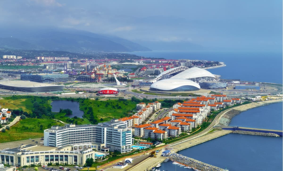
In 2007, Sochi was elected the capital of the 22nd Winter Olympic Games held in 2014. On September 15, 2009 Sochi joined the World Union of Olympic Cities. During the preparation for the Olympics, 500 billion rubles were spent on the development of the city and its infrastructure.
In 2018, the city hosted matches of the World Football Championship.
The most important factors that attract tourists to Sochi are warm subtropical climate, lush sea, abundant mineral springs, close proximity to the mountains, well-developed tourism and recreational infrastructure. The virgin Colchian forests of the Western Caucasus on the territory of the city (the Caucasus State Biosphere Reserve) are included in the UNESCO World Heritage List.
Of the 3502 sq. km. total area of the resort city, 81% are specially protected areas and sites, e.g. the Caucasus State Biosphere Reserve, the Sochi All-Republican State Nature Reserve, and the Sochi National Park. More than 80% of the city's territory is covered by vegetation represented by a wide range of species that can grow at different altitudes. You can see subtropical forests and glacial highlands vegetation on a single day.
Sochi is an all-season resort, there are 705 classified accommodation facilities on its territory, among them are 66 health resorts, 20 spas and recreation centres, 1 balneary centre and 618 hotels featuring 42 new hotels managed by 12 world leading hotel chains, including Swissotel, Rezidor, Hyatt, Accor, Marriott, Rixos, etc. Among them are resorts, which are famous in their own right, i.e. Matsesta, Khosta, Krasnaya Polyana, Dagomys, and Adler. There are 183 beach areas, more than 100 tourist facilities, and about 70 tour operators.
Founded in 1857, Maykop is now the capital of the Republic of Adygeya. The town grew out of a small fortress on the right bank of the White River. Maykop is one of the most beautiful towns of the North Caucasus, the administrative and cultural center of Adygeya. It has plenty of amenities and can serve a perfect base for hiking in the Caucuses Nature Reserve. If you plan to visit the Reserve from the Lagonaki checkpoint or the Eastern District Forestry, it is more convenient to stay in Maykop. The Adygea Science Department of the Reserve is also located here.