
Scan the QR code and open PeakVisor on your phone
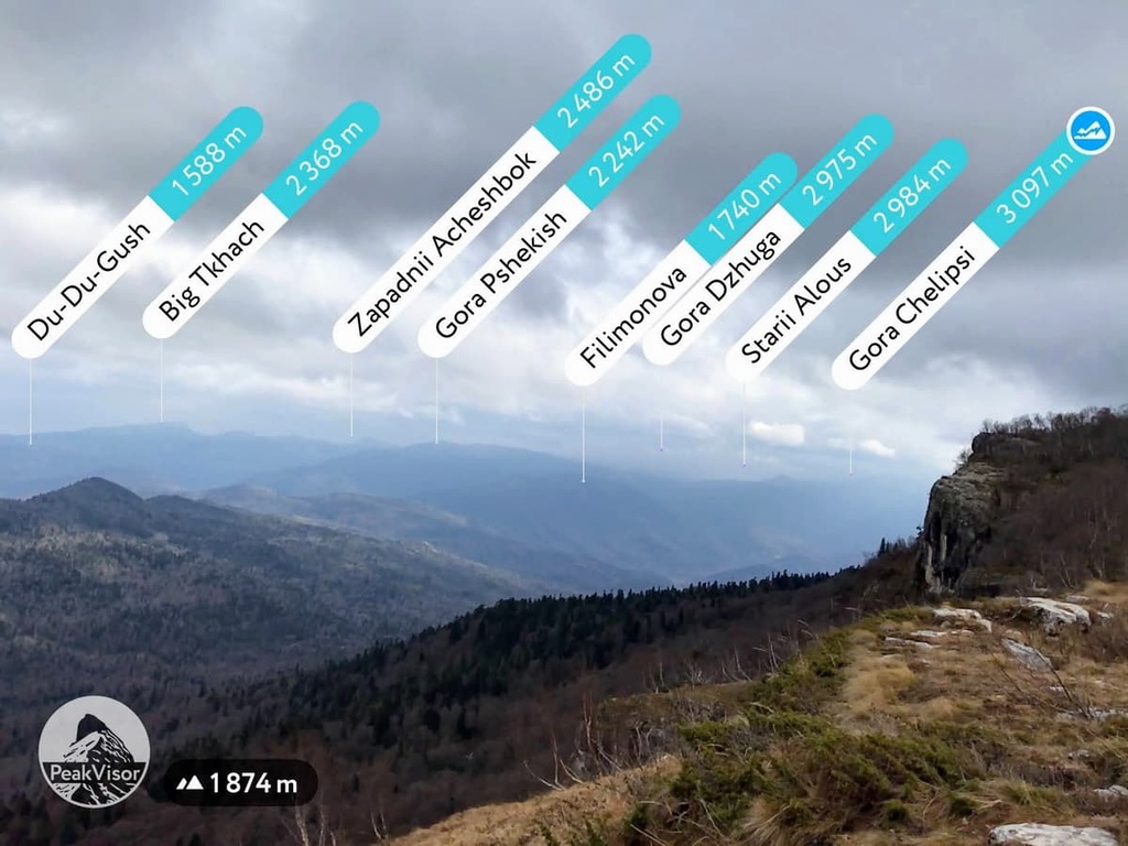
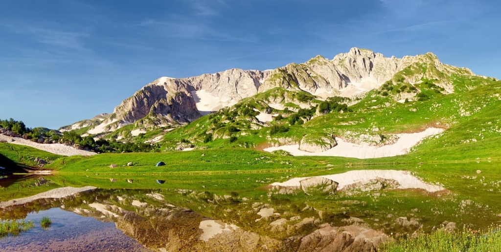
Adygea is home to 100 named mountains. The highest is Gora Chugush at 3,238 m.
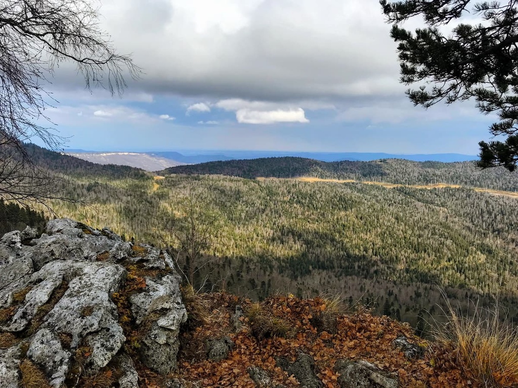
A small republic of Adygea is hidden in the heart of the Krasnodar Region in the south of Russia. Despite its small size, there are 102 named mountains here and so many natural attractions that no matter how many times you come here, each trip will open up new facets of this wonderful country.
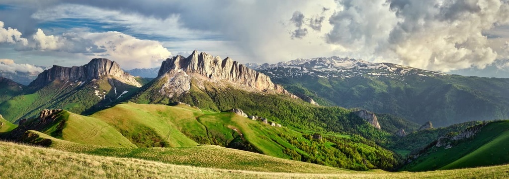
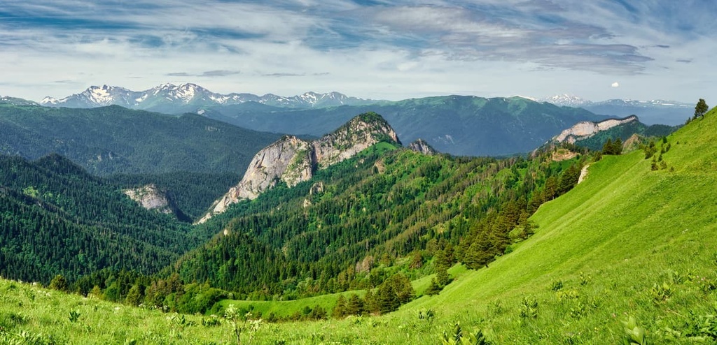
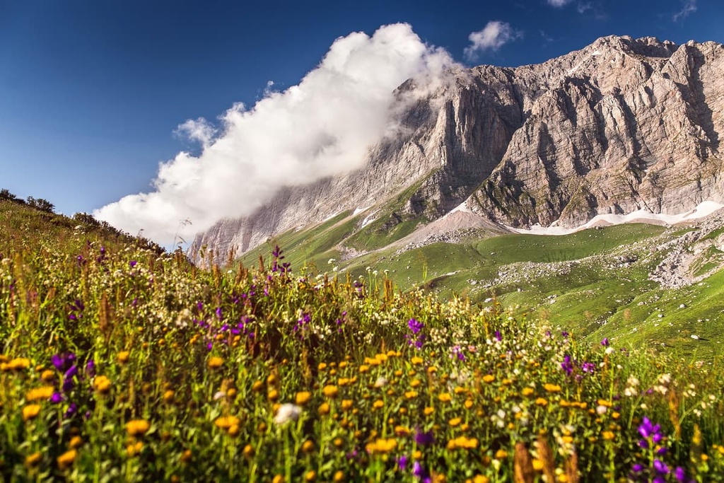
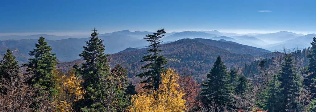
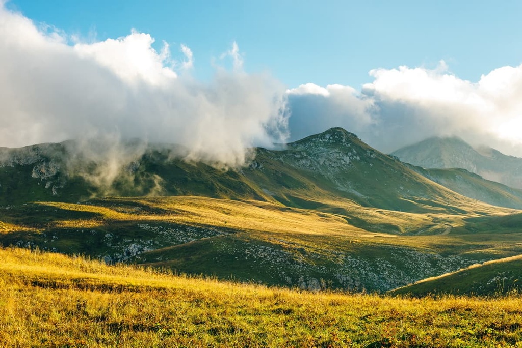
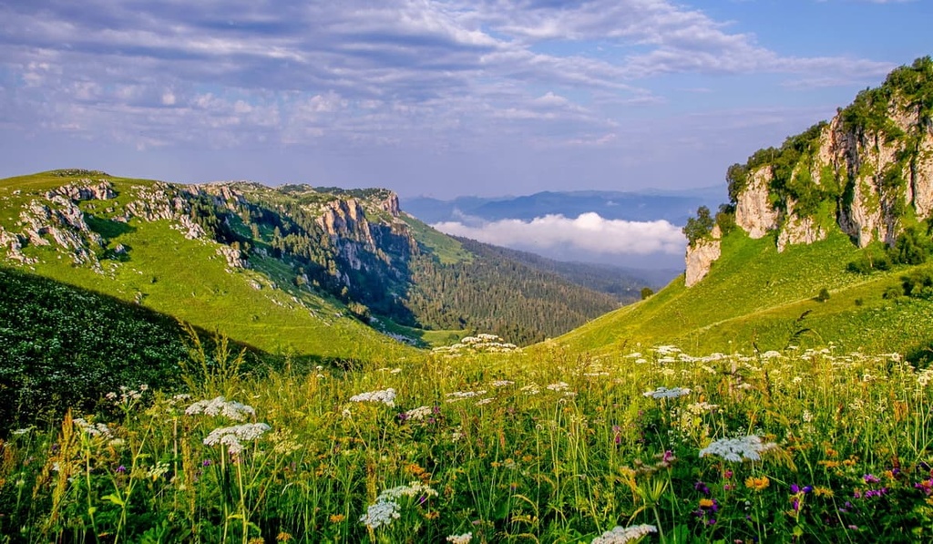
There are snow-capped mountains and alpine meadows, the waterfalls and mysterious caves, the canyons and magical forests in Adygea. It is the land suitable both for families with children and travellers who prefer active kinds of rest, you can have any type of fun here at any time of the year.
The republic is quite young and is considered to be one of the smallest subjects of Russia. Adygea is part of the Southern Federal District. Maikop is the capital of Adygea. The population of Adygea is 463,167 people (as of 2021). Adygea has 2 cities, 3 small towns and 48 villages which are called rural settlements and have different names depending on the type of the village and its size - auls, stanitsas, villages and khutors.
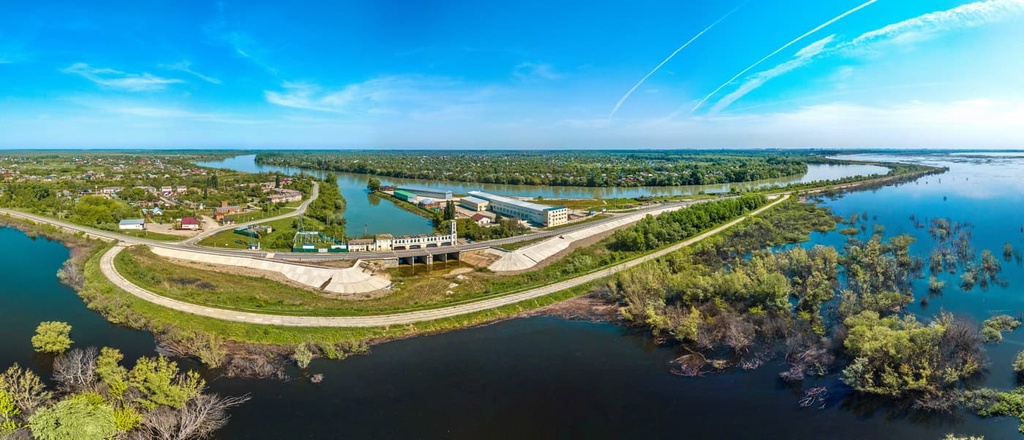
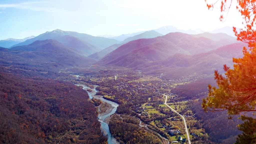
Adygea is located in the southwest of the Russian Federation, occupying the central part of the Prikubanskaya (Zakubanskaya) Sloping Plain as well as the northern slopes of the Northwest Caucasus. On the map, the contour of the territory resembles the shape of a mushroom with a thick stalk, in the middle of which the Belaya River flows. The mountain ranges occupy the entire southern part of the republic.
There are 102 named mountains in the region. The highest is Chugush (3,238 m) but the most popular mountain is Fisht (2,867m).
The region is surrounded on all sides by the territory of Krasnodar Region, and borders in the north with the city of Krasnodar. In the north and northeast, Adygea is bounded by the Kuban River and its tributary - the river Laba, whereas in the south there is the Greater Caucasus Range as a natural border.
The main territory of Adygea is located in the valleys of the two main tributaries of the Kuban River - the Laba River and the Belaya River.
The area of the republic is 7,790 sq.km, which is comparable with the area of Wrangel Island (7,800 sq.km) or the three states of Luxemburg (2,600 sq.km). The length of Adygea territory from north to south is 208 km, from west to east - 165 km.
The water resources of Adygea are rich and varied. There are 85 big and small rivers, the main rivers are the Kuban and the Belaya, 4 water reservoirs as well as many high quality mineral springs, the Matsestinskie and others.
The Kuban and the Laba rivers are navigable. The former is considered one of the largest rivers in the entire Caucasus. The rivers have predominantly mixed feeding sources. The Sakhrai, Kisha, Dakh, Fars, Hodz and other relatively small rivers originate among glaciers and eternal mountain snows.
The Belaya River
Since Adygea is a mountainous country, there are plenty of waterfalls, which freeze in winter. Adygea is also famous for lakes and thermal springs. Thermal springs are scattered throughout the region, almost each has tourist complexes built nearby. In the valley of the river Psekups, there is a balneological resort complex called Goryachy Klyuch (The Hot Spring).
Lake Psenodakh is located on the Lago-Naki Plateau. The lake is small, shaped like a wide smile. The scenery here is amazing: there are mountains, rocks, and alpine meadows. Bear in mind that there is a special protective regime aimed at preserving the ecosystem of the lake.
Khadzhokh Quarry is situated near the village Kamennomostsky. Once it was a limestone mining site. Thanks to numerous springs a lake gradually formed at the bottom of the quarry. And due to the fossils of the quarry, the colour of the lake is bright red. The water is transparent and very cold. Nearby there is a tourist race.
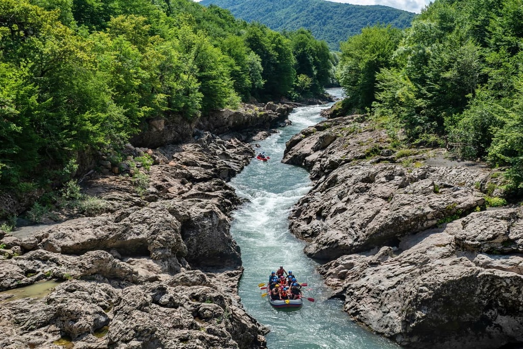
Adygea is a really great place to try active recreation on the water - quad bikes and rafting.
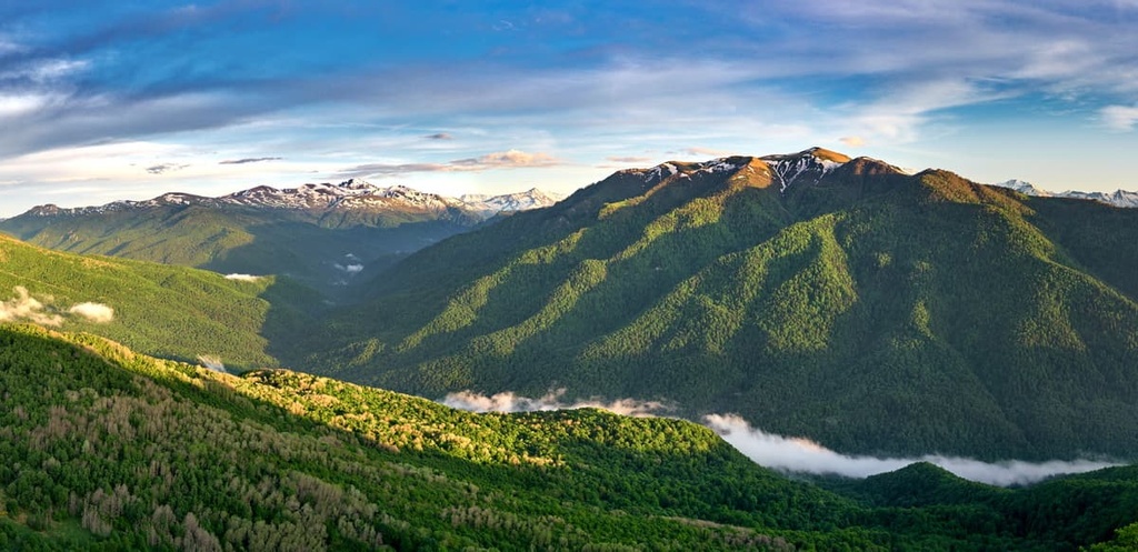
Due to climatic conditions, fertile soils, the proximity of the Black Sea, and the layered terrain, the flora of Adygea is diverse and quite unique. According to scientists, in ancient times the climate here was much warmer, and the vegetation resembled that of a tropical one. Nowadays, over 2000 species of higher plants grow here. Forests are lavish and occupy almost half of Adygea’s territory, mostly in the southern part of the region.
Caucasian fir, oriental beech, yew berry, holly, Rhododendron ponticum, Colchis ivy, and Caucasian bilberry grow in the forests. There are medicinal plants, fruit plants, grains, and fodder plants grown here as well. Many of the species are included in the Red Book, e.g. Caucasian belladonna, Caucasian lily, arcuate birdwort and others. There are also endemics, which can be seen only in Adygea, e.g. Otrana bellflower, Oshtenian gentian and others. Imagine that the Fisht-Oshtenovsky Ridge alone has about 120 endemics.
The animal world of Adygea includes 87 species of mammals, 11 amphibians, 19 reptiles and several thousand species of invertebrates, here also live 275 species of birds, 91 species of fish. You can clearly see the animals distributed according to climate zones. The greatest diversity of species is observed in the forest-steppe belt. And with the ascent to the mountains and transition to the pre-Caucasian plain the number of species decreases dramatically.
The fauna of the forest-steppe zone has no endemic species. Widespread are field and yellow-throated mice, common white-toothed mole, Caucasian mole, less common arу the European hare and fox. During the warm season, there are many birds of prey that feed on rodents and insectivores in this area. Moose occasionally enter Adygea. However, such steppe dwellers as the little bustard (Otis tetrax) and the great bustard (Otis tarda) are practically exterminated.
The forested areas of the lower and middle mountain belt are inhabited by Caucasian subspecies of animals that are usually common in the broad-leaved forests of Europe - bear, deer, forest cat, lynx, badger, and otter.
The animal world of the high landscape zones is rich in endemic species. For example, in the Maikop district one can find Caucasian chamois, Caucasian mouse, Promethean vole, Kuban auroch, stone marten. The forests on the mountain slopes are inhabited by chamois, Caucasian brown bear, Caucasian red deer, Caucasian auroch, fox, wood and stone marten, Caucasian otter, badger, lynx, wild cat and others.
The main attraction of Adygea fauna is the Caucasian bison.
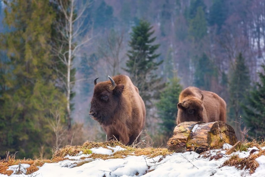
After World War I, only about 500 bison remained in the region. And even the creation of the Caucasian bison reserve in 1924 did not help to save these animals from extinction. In 1927, the last bison was poached and killed by herdsmen. That's how the Caucasian bison disappeared as a species. However, scientists did not give up and set out to revive the population of these animals. A descendant of the Caucasian bison was found in a German wildlife park, and the decision was made to bring a female bison to it. By cross-breeding these animals, the scientists eventually succeeded in reproducing new bison. That was how the Caucasian bison repopulated the Caucasian bison reserve in Adygea. Unfortunately, even today there are cases of poaching, but inaccessible parts of mountain ranges and protection of the reserve help to preserve the restored population.
Despite the small length of the territory from north to south, the climate of Adygea is quite diverse. In the northern flat part of the republic, the climate is moderate continental, in the Caucasian foothills it becomes warm and humid, whereas in the southern and more mountainous part the climate is getting colder as you move up to the highlands. This is determined by the peculiarities of the geographical location of the region - the proximity of the warm and ice-free Black Sea, the vastness of the flat area, the height and location of mountain ranges. On the one hand, the Black Sea is a kind of an accumulator of heat. It accumulates thermal energy in summer and releases it gradually into the surrounding areas in winter. On the other hand, the Black Sea is the cradle for cyclones which carry moisture to coastal areas. The mountains serve as a natural barrier to humid winds, that is why the territory of Adygea enjoys significant humidification in spring and summer. Because of this, precipitation in Adygea is much higher than in the nearby Krasnodar Region, and it is quite uneven, especially in the Caucasian foothills and the mountainous zones.
Winter in Adygea is moderately cold, mild, with little snow. It does not begin immediately, first there is a period of some cold settling in and occasional thaws. The coldest month is January. Its average temperature varies from -2.0°C (28.4F) in the plain part to -4.4°C (24F) in the foothills. Absolute minimum can reach -30 to -35°С (-22/-31F). Winter thaws are possible, they cause snow melt, the ice cover gets broken and rivers often become flooded.
Snow cover on the plain has a small height of 6 to 10 cm, which cannot be said about the foothills and mountain areas, where the snow thickness ranges from 50cm to 2 or 5m on average.
As to the summer, the average monthly air temperature in July is +23.2°C (73.8F) in the plains and +20 to +22°C (68-72F) in the foothills. Summers are hot and dry in the plains and much cooler in the foothills. High in the mountains, the air rarely gets warmer than +10°С (50F).
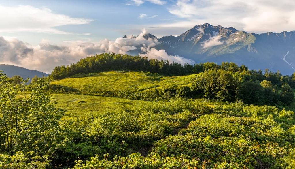
Adygea can boast of a great abundance of hiking routes that would acquaint visitors of any degrees of fitness with the local traditions and the main attractions. Most trails are available in the winter as well. Keep in mind that visiting the mountainous part of the region involves staying in specially protected areas (parks, reserves or wildlife preserves), which have their own rules, permits and restrictions.
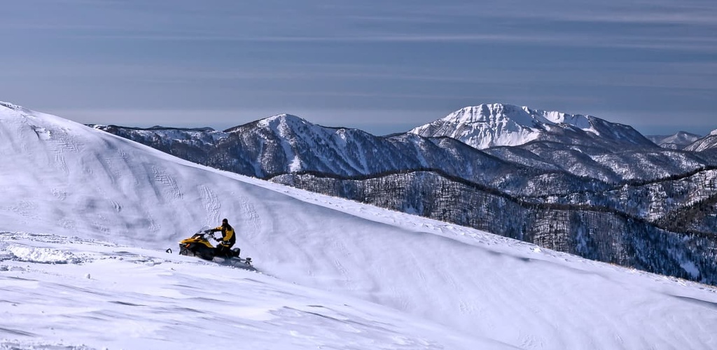
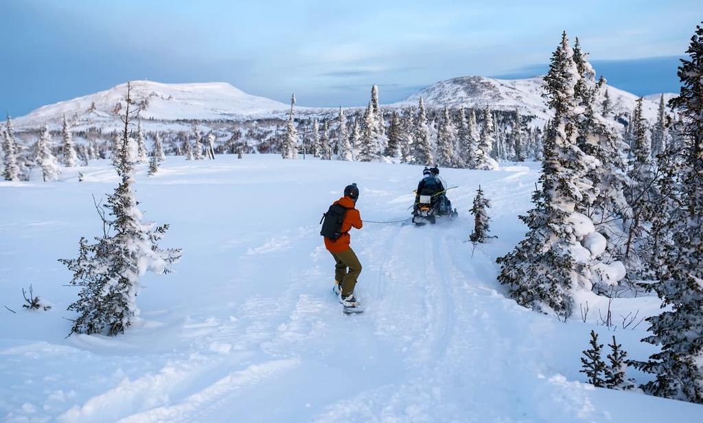
Adygea offers ample opportunities for winter holidaymaking. In addition to mountain skiing, snowboarding and tubing, fans of extreme sports can go winter rafting on the ice-free Belaya River. The trips last from 1 hour minimum to almost a day, and the impressions will last a long time! In the cold season, there are also available rock-climbing parks, winter jeeping, snowmobile rides, and pilgrimage to St. Michael the Athonite Monastery.
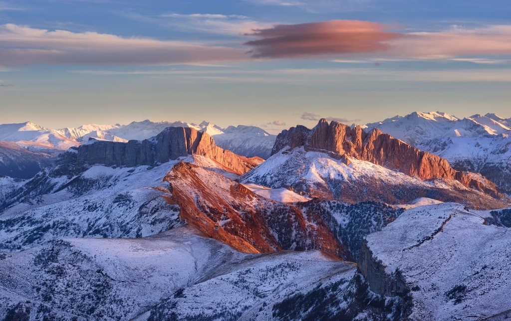
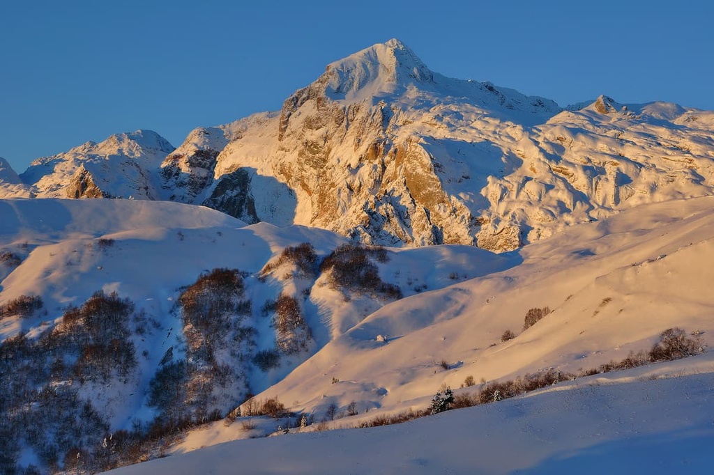
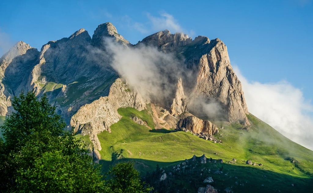
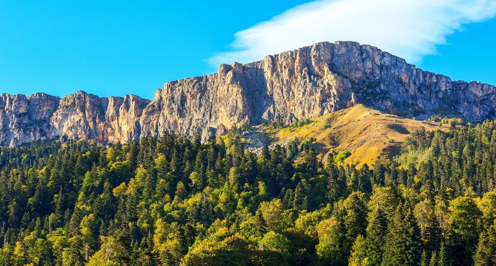
The name of Chugush Mountain has Adygeian roots and according to one version it translates as the Peak of the Earth. ThelLocals respect and take pride in this mountain which is covered with glaciers and numerous trails. The mountain is located in the very south of the Republic of Adygea, on the border with Krasnodar Region. The highest peak is Chugush (3,238 m), which is surrounded by West Chugush (2,700 m), East Chugush (2,675 m) and South Chugush (2,760 m) Peaks. There are many other high peaks, whose height reaches 3000 m, but they do not have official names. Chugush is the mountain where the Berezovaya River originates.
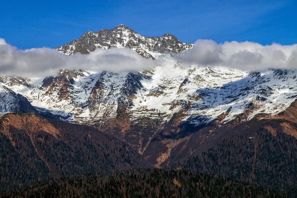
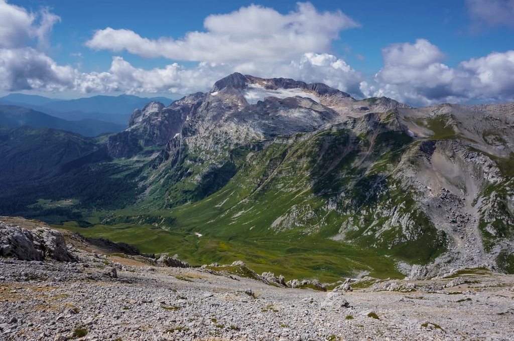
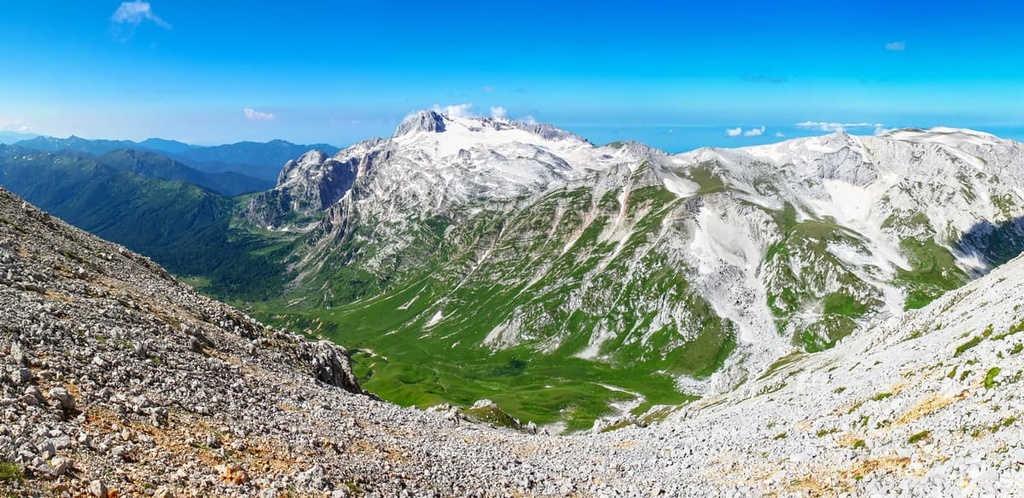
Fisht Mountain (2,868 m), as well as the Lago-Naki Plateau, is located not only in Adygea, but also in the Krasnodar Region. And it is the highest point of the plateau. The name in translation from the Adygean language means ‘a white head’ or ‘a grey head’. Fisht has become widely known due to the Olympic Stadium in Sochi, which was named in its honour.
As usual, there is Fisht and the nearby Oshten come with egends attached. According to one, when the locals were attacked by enemies, the elders organised three detachments. The first, consisting of old experienced warriors, was led by Fisht. The unit was defeated. The second troop of middle-aged warriors, commanded by Oshten, also failed. The youngest ones were led by Lago. But they too fell on the battlefield. Then Lago’s bride Naki took up arms, led the rest of her soldiers into battle and defeated the enemy. Since then, the nearby plateau became known as Lago-Naki, and the two neighbouring mountains - Fisht and Oshten.
You can climb to the top by one of several routes of varying difficulty level. There are routes for beginners and for experienced travellers. According to one of the versions proposed by explorers of the territory, once upon a time Fisht Mountain used to be an island. This version is confirmed by the coral structure of the mountain. The mountain holds several treasures. One of them is the Maly (Small) Glacier, which is the lowest glacier in the Caucasus. It is located at an altitude of 1,980m above sea level. Another treasure is the Pshekhsky Waterfall. It is one of the highest waterfalls in Adygea and Russia - the powerful streams of water fall from a height of 250m, and its depth is still unknown.
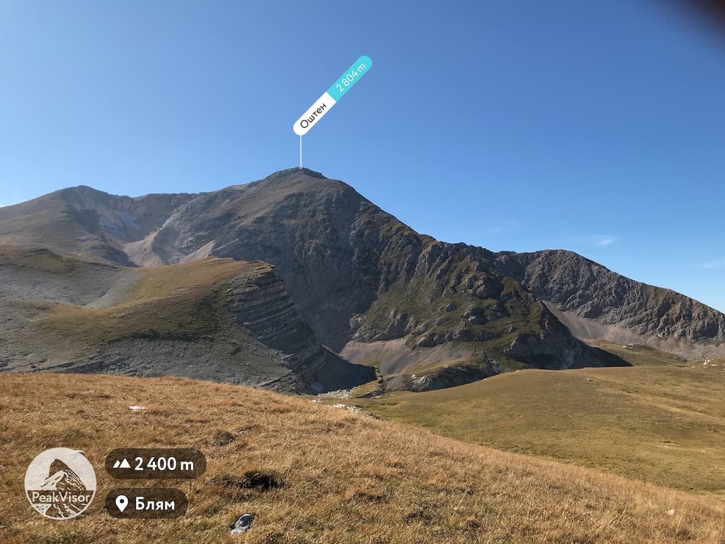
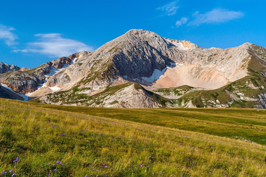
Oshten Mountain (2,804m) is part of the so-called Fisht-Oshten Ridge, which in turn is part of the Caucasus Range. Oshten is less known, but attracts many climbers. The snow line begins at an altitude of 2,737m. All other neighbouring mountains are covered with forests to the very top.
Mount Oshten actually has five peaks of slightly different heights. The highest (2,804 m) of them has a wide flat top in the form of a sloping table, it offers enough space for several large tourist groups to camp. On the eastern side of the slope, there is a large firn cirque. From the northeast runs a long canyon, the favourite place of freeriders.
At the top of Oshten, the snow doesn't melt for most of the year, thanks to which the mountain has got its name. In winter, the thickness of the snow cover is up to 6m. In the Adygean language the word Oshuten means ‘eternal winter’ or ‘eternal snow’, other interpretations of the name run as the gatherer of clouds, the place where hail gets stuck or the water mountain. Rightfully so, Oshten is notorious for its bad temper. Most of the time, the peak is covered in clouds. You can see its beauty only early in the morning (the most advisable time to start your climb because there is usually no precipitation before noon) or right before a bad weather spell. The locals say if you see the tops of Oshten and Fisht well during the daytime, a storm is coming.
The best time to visit is mid May to the end of September. There are 10 glaciers on Fisht and Oshten slopes, the ice has a bluish colour and striped texture. It is formed from granular snow, which is called firn. The glaciers are the sources of several rivers: the Tsitse, Pshekha, Armyanka, Kurdzhips, Mutny Teplyak, and Belaya.
Oshten is composed of limestone, which makes the mountain light grey. The peak is quite easy to climb. Several hiking trails lead to the top; they are marked with special signs and conical pyramids of stones (stone tours). Most tourists start from the northern slopes of the Greater Caucasus Range - from the Yavorovaya Glade. Climbing can be done from the south from Fisht Shelter through the Fisht-Oshten Pass. The difficulty of the routes is not high - 1B and 2B.
The usual route from checkpoint Uzurub is 8 km long, so if you set off early, you can climb to the top and come back in one day. Yet, if you wish to take photos and stop for rest, allow two days for a trip. You can stay overnight at the camp near the Instructor's Gap. Another picturesque place for camping is the shore of Lake Eighth of March. The total elevation gain is about 1,200m.
Before going to Oshten and Fisht trails, you pass through the checkpoint Uzurub of the Caucasus State Nature Biosphere Reserve. Here you must buy a ticket (for single tourists) or show the pass (for organised groups by prior order). The cost per day is 300 rubles for adults, 150 rubles for school children under 14, preschoolers go free of charge.
Oshten is one with the neighbouring Fisht Mountain (2,867 m), the natural boundary with which runs through a deep gorge in the rock massif. Along the gorge, stretches a path to the Shitlibk Pass, which can be used to exit to the Black Sea. Mountain Pshekho-Su (2,743 m) is next to Oshten’s western slope, there is a pass of the same name between them (another name is Fisht-Oshtenovsky Pass).
To be fair, Fisht-Oshten massif consists of three peaks, the third mountain is called Pshekha-Su (2,734m), it is also spelt as Pshekho-Su.
Pshekha-Su is translated from the Adygean language as ‘Water of a Countess’. The second name of the peak is Chuba. This peak is the lowest of the Fisht-Oshten Ridge, but no less beautiful than Oshten and Fisht. On the north-eastern slope of the mountain is a small 100 sq.m. glacier. This is one of the three ancient glaciers of the Caucasus with deep, low-lying crevasses. Approximate dimensions are about 5 km long and almost 3 km wide.
At the bottom of the northeastern slope, there is a karst Lake Pshenodakh, which can be accessed from several sides - from Maikop, the Fisht-Oshten Pass or from the Instructor's Gap.
Climbing Pshekha-Su requires an average level of fitness, but you should bear in mind the elevation gain can be from 500 to 1000m from the parking place, depending on the chosen route. Also, remember to buy a ticket in the Caucasus State Natural Biosphere Reserve, as the mountain is located on its territory.
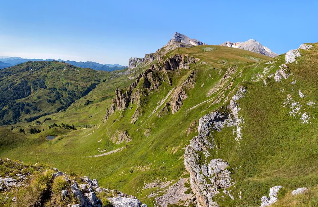
To the northeast from Fisht-Oshten Ridge, rises Blyam Mountain (2,378m), an intermediate point before climbing Oshten. Blyam is covered with snowfields. The summit offers fascinating views of the Lagonaki Plateau, the Armenian and Caucasian Ranges as well as the tree-covered humps of the Stone Sea Ridge.
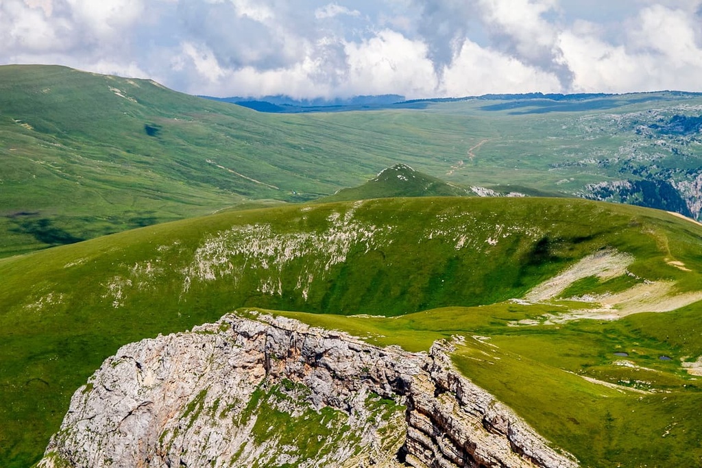
One can say that the Lago-Naki Plateau is a natural treasure not only of Adygea and the Caucasus, but of the whole world. The views from the plateau are ethereally beautiful!
The plateau is located in Adygea and the Krasnodar Region. It is partially included in the Caucasus Nature Reserve. There is a good trail where you can have the great panoramas from the viewing platforms, visit the Boevoy Grotto, take beautiful pictures and enjoy the scenery. In addition, there is a beautiful glacier cosily placed on the plateau.
You can go dog sledding, snowmobiling, sledding, skiing and even horseback riding here.
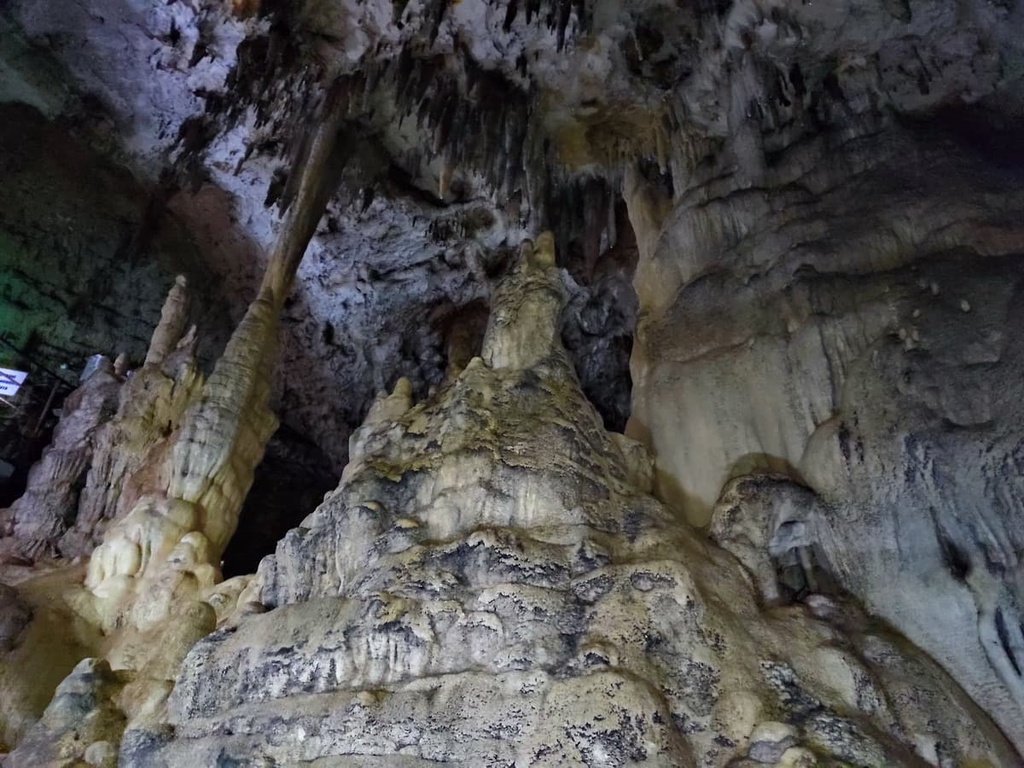
The Azish-Tau Ridge is an elevation in the northeastern part of the Lago-Naki Plateau. In addition to viewing platforms, there are many interesting things here: swings over the abyss, a soaring pavilion, the Pine Glade. And those who visit the Big Azish Cave will see an unbelievable sight. Stalactites and stalagmites grow into huge columns here. Tourists have an opportunity to see only 220m of the 690-metre long cave which has 5 halls. Places for the inspection are well equipped - there are handrails, decking, and lighting.
In winter, you can go skiing, have snowmobile rides, and enjoy hilarious snow tubing from the equipped snow slopes. You can easily rent skiing equipment here. There are many camping sites, cafes, and restaurants in the vicinity.
Bolshoi Tkhach (2,300m) is located on the territory of the Tkhach Nature Park. The name is translated as ‘a forever young god’. It looks like an uneven wall with indented jagged teeth. The mountain immerses you into a fairy-tale atmosphere: its top resembles an ancient city, and the slopes are shrouded in a fluffy green mantle of forests.
Raskol is actually just a mountain (1.161m) but a crevice and a rock. The very edge of the rock is as if cut off from a mountain with a sharp knife, like a piece of cake, which is how the name Raskol came about.
The rock appeared after an earthquake when a huge crack went through the mountain and produced a smaller rock on the side. Over time, the rock moved away from the mountain base, and now looks like an independent mount. The rock reaches up to 110 metres in height that is why some places at the bottom of the crevice do not get any sun at all and it is always cold here, even in hot weather. The width of the fracture varies from two to eight metres and it is better not look up. Nearby flows the river Bzykha with picturesque waterfalls, which reach a height of up to five metres.
It is not easy to reach Raskol because there are many trails in the forest, some signs are non-existent and the terrain is tricky. It is better to hire a local guide. If you go on foot, leave from the place where Maykop road crosses the river Bzykha, walking on the right bank of the river, cross to its other side on a log after about 150m of the road. After crossing on the log, the path will continue, follow it to the next river, cross it over the bridge, then in 500m the path will divide - you take the left, continue through the brook and gardens. In a couple of kilometres, you come to the Bzykha head, go up the path from there and you will see Raskol Rock. Be careful on the last lap because the path goes on a loose stone field.
The southern entrance to Raskol feels like the portal from Lord of the Rings. In the north, Raskol ends up in a steep cliff, that is why it is better to come back the same way.
Raskol offers stunning views of mountains Monakh, Bolshoi Tkhach, Acheshbok, Dzhuga, Pshekish and others. From the southern entrance, you can see the slopes of the Engineer Ridge.
A visit to this landmark is possible only if you like long walks in the woods. Even the sign indicates that you have to walk a long way to your destination. The rock is about 2.5 km from the village Dakhovskaya located on the Una-Koz Ridge. The trail to Devil’s Finger Rock is interesting, on the way you can see many other curious objects, such as the Devil's Arch. By the way, if you cannot walk long distances, you can go on horseback or even by car.
The route to Molotok (Hammer) Rock is 3-4 km long. You can set off from two starting points: at the parking lot of the Khadzhokhskaya Cave or at the bridge over the river Aminovka. The trail goes up along the left side of the Aminovskoye Gorge and leads to a big cliff - Molotok Rock. This rock or more a boulder actually is literally balancing over the abyss. On the way up, there is a view of the deep canyon called the Rocket Mine, as well as a through hole called by the locals the Window to Europe.
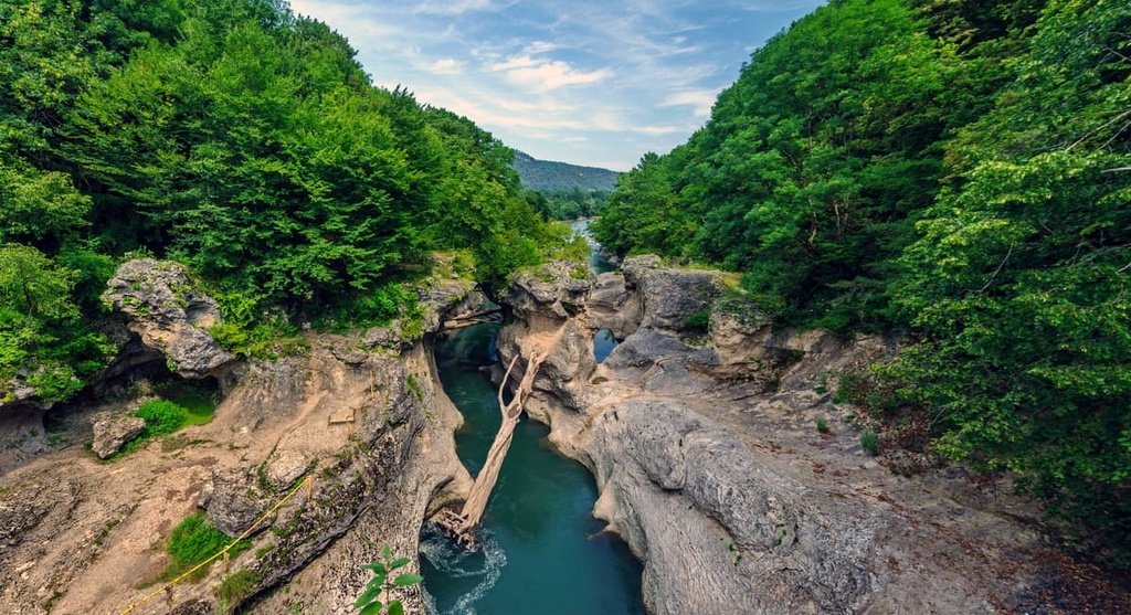
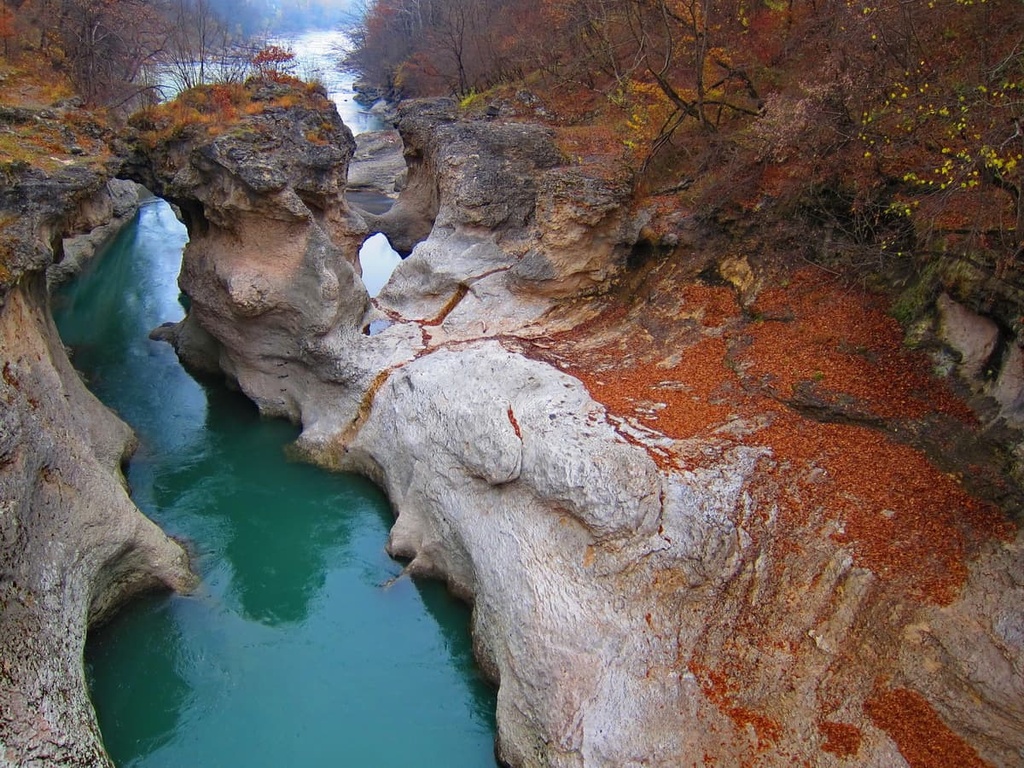
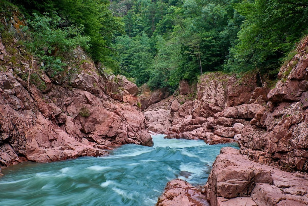
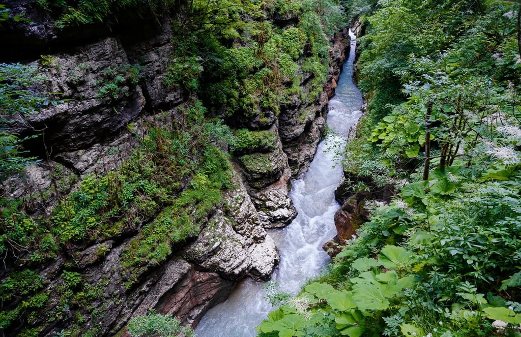
The Khadzhokhon Gorge is a small canyon naturally made by the Belaya River. The length of the canyon is about 400m, its width is 7m. There are observation platforms, natural stone bridges, and interestingly shaped rocks on the way to the gorge. The trail is equipped with railings in some parts. Local beauties can be admired at any time of year. Below the gorge, there are aviaries with representatives of local fauna.
A simple route, 2-5 km long, depending on what sights you decide to see. All landmarks are located on the territory of the Caucasus Biosphere Reserve. Here you can walk the leopard's eco-trail, visit the artificial waterfall on the Molchepa River, or have a look at the Nature Museum.
Near the village of Guzeripl is the Yavorova Glade (Yavorovaya Glade) - the starting point of many guided hikes. The trails are marked, there are gazebos and benches along them, and many signs to guide the way.
The Khamishki Route is 6-8 km long. The highway bridge over the river Bzykha is the starting point of the route. On the way, you will see the waterfalls of the river Kutanka. In summer, they dry up but in spring and winter, they are filled with powerful waters and you can get a very beautiful view. After the first waterfall, there is a steep ascent to the Angel's Wing Grotto. Closer to the end of the route, there are Monakh (Monk) Mountain viewing platforms. You should take flashlights and a navigator with you when hiking because you might not be able to come back before dark.
Monakh (Monk) Mountain is not high, just 1,508m tall, but it is remarkable. Its flat top will not let you pass by. There is a legend that the image of the mountain was carved by a monk, making amends for his sins. From a certain angle, the mountain does resemble the face of a stern old man. Going to the Monakh, you can visit grottoes, the remains of dolmens, and a spring.
The Rufabgo Route is 8-10 km long, it has a minimum level of difficulty, which makes it suitable for walks with children. It is one of the most popular places in Adygea. The trail starts from Khadzhokhskaya Gorge. In total, the route has 16 waterfalls, you can easily and quickly get to four of them - the Maiden's Plait, the Heart of Rufabgo, the Cascade, and the Noise. Once you pass them, the equipped trail is over. If you wish, you can get to the fifth one by climbing up the slope and then moving along the unequipped mud trail. You will see the cascade of two waterfalls, one of which is called the Cup of Love. This path can be shortened by choosing a toll bridge over the Belaya River. The highest waterfall in the gorge is called the Grandiose, and the lowest is The Three Brothers, which is twice shorter than the Grandiose.
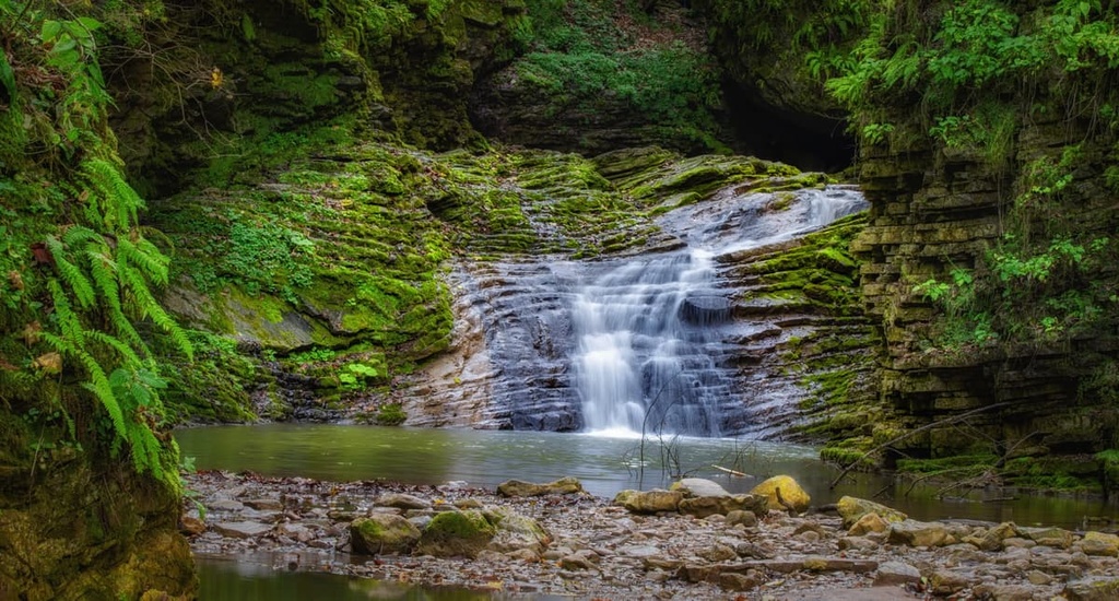
The Rufabgo Gorge is picturesque not only in summer, but in winter as well. There are grottoes, stone labyrinths, and frozen waterfalls. The height of rock passages sometimes reaches 150m - an impressive sight! In addition, there are historical sites in the gorge: an ancient altar, an underground prison in a mediaeval fortress, and many menhirs - vertically placed huge oblong stones.
The Meshoko River Gorge has a fascinating 3-km long route. The trail is not equipped, there are no handrails or stairs, so you should move carefully. On the route, you will see majestic 70-metre tall rocks with grottoes and several small waterfalls. The Meshoko Gorge is also called the Bear Valley. It is here that the archaeologists found the camp of primitive people. Near the upper observation decks there is a park called Meshoko for extreme fun. You can walk in the park for free.
The river Belaya forms the Granite Gorge, the route along the gorge is several kilometres long. The river channel narrows significantly in this place. The river seems to be squeezed from two sides by beautiful steep cliffs, which generates a powerful and noisy stream of river water. Through the gorge, there is the road to Guzeripl village. The route is equipped with viewing platforms. There are many other natural attractions in the vicinity. For example, you can go to Trezubetz (Trident) Mountain (1,050m) or the Golden Spring.
Another beautiful place in Adygea is the Guam Gorge. In ancient times, there was a highland lake here. Nowadays there is a huge picturesque gorge in that place. Winter brings out a particular charm - there are frozen waterfalls that offer a fabulous view. When it snows and you hear the rumbling sound of the Kurdzhips River, you get the feeling that you are in a magical place.
The Dudugush Ridge is one of the most beautiful places in Adygea, but it is not popular. First of all, this is due to the fact that there are no equipped routes and good roads on the ridge. Therefore, rare tourists climb to the top, they use off-road vehicles to get closer. But almost no one goes here on foot because of the long distances. In translation from Adyghe language, Dudugush means strange, unpleasant, cold, frightening. Who knows, maybe just because of the difficult way to the top, it got such a name. Those who have been there, on the contrary, usually call this place cosy, sunny, and picturesque.
The Dudugush Ridge is just a bit over 1,500m high and extends for 20 km. The ridge stretches from the Granite Canyon to the Kisha cordon. In the northern part, it is entirely covered with forest, in the south the ridge is open. It offers views of the Lagonaki Plateau, the Kamennoe More (Stone Sea), Mount Pshekish, Bolshoi Tkhach and the mountains of the Caucasus Nature Reserve. The ridge itself is not part of the reserve. Villages from which you can start climbing are Novoprokhladny and Khamyshki.
According to the maps, there is no sea in Adygea. But actually there is! It is not just any sea, but a stone one. You can go for a walk on the Stone Sea (Kamennoe More) Ridge. It is a simple one-day trip, suitable for families with children. On the way you can encounter steep rocky precipices, deep sinkholes covered with snow and endless alpine meadows.
The Stone Sea is a long rocky ridge that stretches from the Azish-Tau to Mount Oshten. The average height of the ridge is 1,800m. The slopes are gentle on the side of Mount Oshten, they are home to the head of the river Kurdzhips. On the other side though, the slopes are steep and drop into a bottomless abyss. From that edge opens a remarkable panorama of the mountains of the Western Caucasus.
The Big Azish Cave is dark and mysterious, it hides at an altitude of 1,520m, surrounded by beech and fir forests. The visit will take a good two hours. There are huge vaults, an underground river, and various speleothem objects. Make sure to visit the Great Gallery located in the eastern part of the cave.
The names of the Big Azish Cave halls are symbolic. The 18m-long Bogatyr Hall got its name for the impressive size, the Nuptial Hall is a symbol of eternal love: here two limestone pillars of different colours merged into one. There is also the Wishing Palm Hal with an illuminated green lantern-rock pillar. You cannot touch it. It is better not to touch anything since it destroys the microclimate of the hall and can prevent the formation of a new stalactite. But you can stand nearby and make a wish: such is the tradition here. It is also worth approaching the Lamp of Aladdin here but again, no touching.
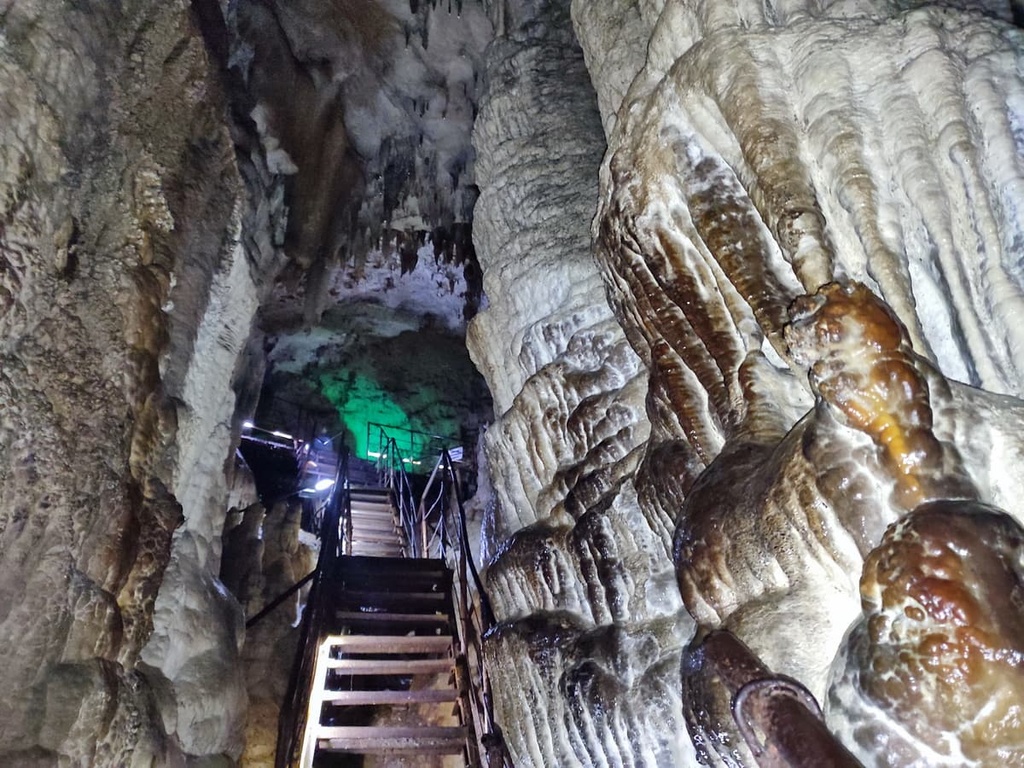
It is very cold in the cave. The constant humidity reaches up to 98%, the temperature is +5.9C (43F). In winter it can get as cold as 0.6C (33F). We strongly advise not only dressing as warmly as possible, but also wearing thermal underwear. Even if you're going to the cave in July, take a sweatshirt, or better yet a hat and gloves. No heels and flip-flops are allowed in the cave. Stairs are high and slippery, so make sure your footwear is comfortable.
Not far from the Big Azish Cave is the Small Azish Cave which used to be considered a part of a single cave system and was connected to the Big Azish Cave. But it is an independent entity. The length of this cave is 66m, three halls are available for exploration. The Small Azish Cave was discovered in the 1970s.
The Dusty (Pylnaya) Cave entrance is visible from the trail to Devil’s Finger Rock, it is just 500m from the rock. The entrance is a large triangular fault with rock debris at the beginning. The cave is completely dry inside, so it is dusty and thus justifies its name. The length of the cave is about 30 m, according to some reports, it continues farther as a narrow passage leads to another hall.
The Nickel Tunnels have been of great interest for those who are interested in mineral exploration. It is the abandoned site of old Soviet nickel mines (mostly mined in the 1960s) next to a tourist base called Mountain Village. The beautiful minerals and rocks here can be collected and taken home as a souvenir.
Khod v Preispodnuyu aka Entrance to Hell is one of the deepest mines of the Bolshoi Tkhach Mountain. The total length of the cave is 230m, 192m deep,. The entrance is located almost in the centre of the Knyazheskaya Glade - a parking place for tourists, near a small drying lake on the watershed of the rivers Hodz and Maly Sakhrai at an altitude of about 1800m.
The opening of the cave to the underworld is a series of wells 15-40m deep which are connected by short steep-sloping passages. At a depth of 40m, there is a small branch with a dry 5-metre-deep well. In general, there are not that many speleothems, the most attractive in this respect is the entrance well. It is impossible to descend into the cave without special speleological equipment.
The cave is located in the valley of the river Rufabgo, 400m from the first waterfall. Unlike other caves, Skvoznaya (Through) Cave has an elongated shape, tapering to the top and forming a karst gap, which allows the daylight to come in. The bottom is strewn with stones of different shapes and sizes. There are several ways to get to this cave. The easiest starts from the waterfalls Rufabgo, to get to which you can go through a toll bridge or bypass the bridge by a free path running along the precipice and the infamous rock called ‘Jesus, take the wheel!’.
There is a picturesque rock, full with grottos, located on the southern slope of the Rocky Range in Adygea near Pobeda village. The outcrops of rock form a long series of niches here; one of these recesses is called the Skull Grotto because of its characteristic similarity in shape. There are several other niches and cornices in the rock near the grotto, some of which were even used as fireplaces and tent sites. Inside, the Skull grotto is enormous.
From the grotto, you can see a wonderful view of the Lago-Naki, Tkhach (from the back side), Dudugush and Pshekish mountains. When the weather is good, you can even see Elbrus.
The trail is easy, about 7 km long with 280 m altitude difference; it starts from the Monastery in Pobeda village.
The mountainous part of the Republic of Adygea is on the UNESCO World Natural Heritage List. It is there that most of the natural attractions of the region are concentrated.
The list of specially protected natural territories includes:
Each specially protected natural area has its own rules of visitation. For example, the Caucasus Biosphere Reserve allows only for one single one-day excursion in winter. A permission for a longer period of time at this time of year will not be granted due to the inability to predict the vagaries of nature. Winter weather is turly unprdictable in Adygea. Thus, in order not to put travellers in danger, the staff of the reserve give permission only for one-day routes in cold season.
All recreation facilities of the Republic of Adygea are concentrated on the Lago-Naki plateau - from the Stone Sea Ridge up to the Fisht-Oshten massif. It is worth noting that the local recreation bases are still in the initial stage of their development. So most of the trails are intended for experienced sportsmen only. But there are also excellent slopes for beginner riders. Extreme tourists usually prefer the slopes of Abadzesh, Pshekha-Su, Oshten, Blam mountains.
The most famous ski resorts are the Lago-Naki Centre and the Azish-Tau Tourist Complex. In addition to mountain skiing, the resorts offer related services, including guided tours to the natural attractions of Adygea.
In winter, mountain climbing, skitouring, freeride, drytooling (passing rock routes using ice tools), and one-day snowmobile tours are in high demand.
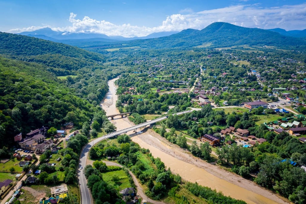
Maikop aka Maykop is considered one of the most beautiful and comfortable cities in the North Caucasus. It is the administrative and cultural centre of the Republic of Adygea. It can also be called the industrial capital of Adygea because about 60% of the industries of the region are concentrated there. The town was founded in 1857. Originally, it was a settlement that grew out of a fortress standing on the right bank of the Belaya River, at the northern foothills of the Caucasus Range. According to the most widespread version, the name comes from the Adyghe word ‘Myekuaphe’, which means the Valley of Apples.
The city is world famous for its archaeological excavations of the late 19th century, during which the scientists discovered Oshad mounds in Maikop; those mounds date back to the Bronze Age. Today some of these finds are exhibited in the Hermitage Museum in Saint Petersburg, Russia. The place where the first mound was excavated is marked by a small monument; it can be found in Kurgannaya Street.
Friendship Square with the monument called Friendship is naturally in the city centre. The monument is dedicated to the 400th anniversary of the union of Circassia (formerly known as Adygea) with Russia. There is also a monument called Hearth - the Monument of Memory and Unity dedicated to the memory of the victims of the Caucasian War (1817-1864). Nearby is Lenin Square, surrounded by government buildings.
There are plenty of opportunities for culture vultures. In Maikop, there are a large number of professional and amateur music bands, the Chamber Music Theatre, the Philharmonic Hall, two drama theatres (National and Russian), the Nalmes Concert Hall, the National Museum, the North Caucasus branch of the State Museum of Oriental Art.
The outskirts of Maikop also have plenty on offer. There are the main tourist sites of Adygea - picturesque gorges, canyons and caves, waterfalls, the Lago-Naki Plateau etc. In Goncharka Village, you can see an arboretum with a total area of 150 hectares. On its territory, there grow more than 350 plants, many of which are exotic. Walking here, drop by a zen garden. Near Dakhovskaya village, there is an architectural monument - Dakhovsky Bridge.
This 60-metre-long stone bridge spans the Dakh River. For many years, it was used to its full capacity, withstanding multi-ton cargoes and even tanks passing over it. Not a single crack ever occured. Nowadays the main traffic goes by the highway built nearby, and the bridge has become a local landmark.
You can have a bird's eye view on Adygea from the Savran Cableway.
The Savran Cableway is located on Dakhovskaya Glade in front of the junction Guzeripl - Lago-Naki, just 500 metres from the tourist complex Dakhovskaya Sloboda. The cableway is quite young, it was launched in 2014. The length is 1.5 km. It rises to a height of 1 km. The final point in the route does not mean the end of your personal route - you can go father to the cave in the Grotto of Wishes or to take a walk on the Greater Caucasian Range.
Another way to have no cheap thrills is to visit the Tethys or Mishoko Rope Adventure Parks. They are both located on the Una-Koz Ridge near Kamenomostsky village. You can walk over the abyss on an aerial trail, fly on a huge swing over the abyss, do some paragliding and bungee jumping or try going at high-speed down the canyon. In winter, you can go ice climbing and conquer frozen waterfalls. You will have an unforgettable experience!
There is no airport in Adygea, but you can fly to Krasnodar and then take a bus, a car or a train to Maikop or Belorechensk or the villages Kamenomostsky, Guzeripl, or Dakhovskaya. Alternatively, you can drive from Sochi, there is no bus or train service from there.
Adygean cheese is the top league present! You can buy different kinds of Adygean cheese in the market or even in the reserves: salty, smoked, young, brynza, or cheese popcorn (hollow balls of dry smoked cheese).
Adygean cheese, aka Matakuaye or Latakay or Circassian cheese, is one of the main products of Adygean (Circassian) cuisine, it is a relative of bryndza, feta, and mozzarella. It is made from whole sheep, goat, or cow milk. Adygean cheese is mainly a soft young cheese of white colour, often with a creamy hue. It has a sour, slightly salty taste and a delicate, soft consistency. Externally, fresh Adygean cheese usually comes in the shape of a low cylinder with slightly convex sides and rounded edges, weighing no more than 1.5 kg. The outside of the cheese head is quite elastic, the inside is relatively soft. Smoked Adygean cheese is drier, its surface is darker, but it keeps longer, especially if you have to travel.
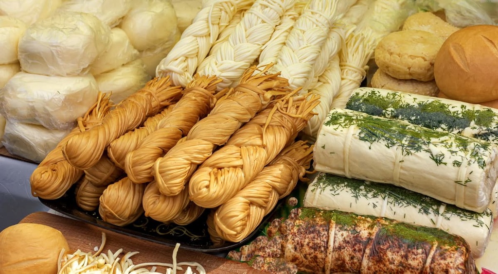
The longest stored Adygean cheese is the dried one. It is a local variety of qurut or Kashk, a typical cheese of Iranian, Afghan, Pakistani, Turkish, Kurdish, Mongolian, Central Asian, Transcaucasian and the Levantine cuisines. Traditionally, it was the food of hunters, shepherds, warriors - anyone who needed to take cheese on the road. Dried cheese is very hard and salty. For comparison, Parmesan retains up to 40% of moisture, whereas Adygean cheese has just 20%. Roquefort has 1.8% of salt, while the dried Adygea cheese has 2%. Adygean dried cheese is not dried in the sun, always in the shade. For long-term storage the dried cheese is covered with grain in boxes, it is kept in barns, which provides a stable humidity to the cheese and eliminates the temperature fluctuations. Such cheese can be stored for several years. Traditionally, before use, dried head of cheese is rinsed by boiling water or is dipped in boiling water, previously being wrapped in a linen cloth. If you are looking for a gift with a twist, Adygean cheese is a nice option.


Yes. Adygea has 100 named mountains. The highest is Gora Chugush at 3,238 m.
The highest mountain in Adygea is Gora Chugush, at 3,238 m.
Adygea has 100 named mountains.


