
Scan the QR code and open PeakVisor on your phone
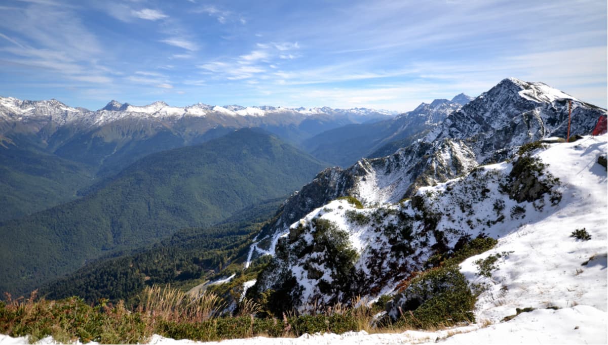
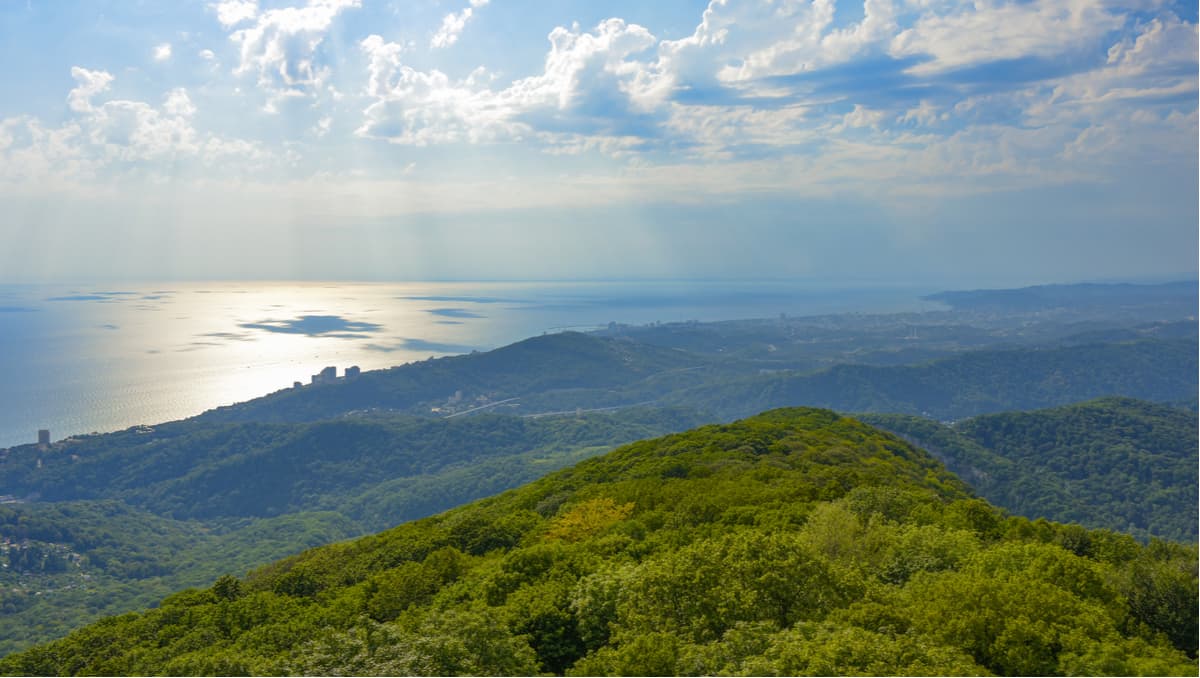
The Sochi National Park is one of the first national parks in Russia. It is situated on the territory of the Greater Sochi stretching from the borders with the Tuapse Region, between the estuaries of the Shepsi and Magri rivers in the north-west to the borders with Abkhazia in the southeast and the Black Sea coast up to the watershed line of the Greater Caucasus Range. Most of the park's territory is occupied by mountains separated by river valleys. The foothill zone occupies a narrow strip along the Black Sea.
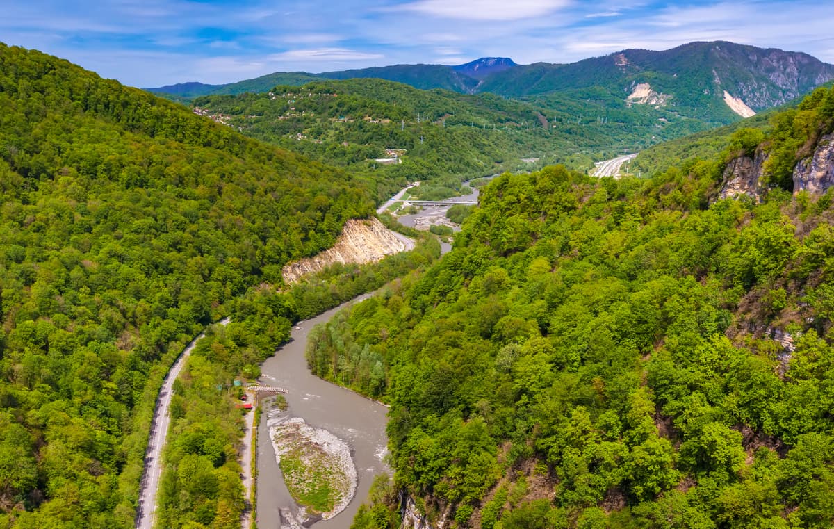
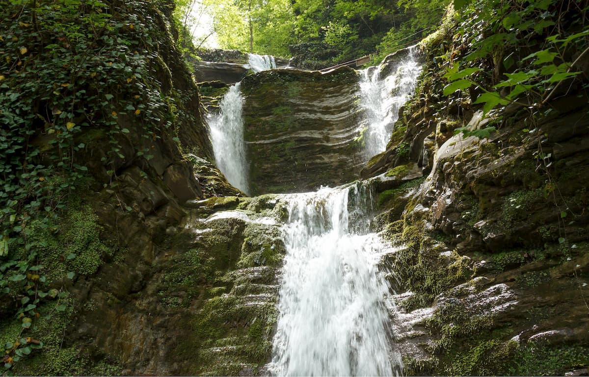
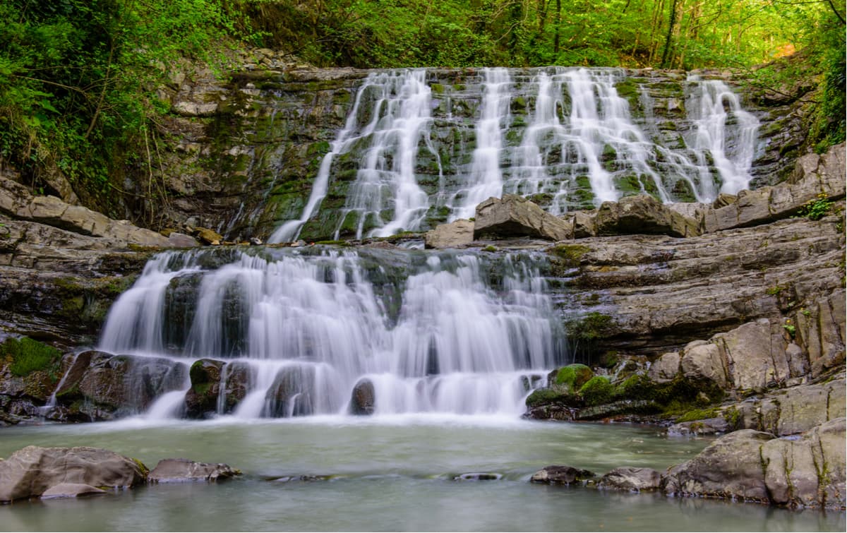
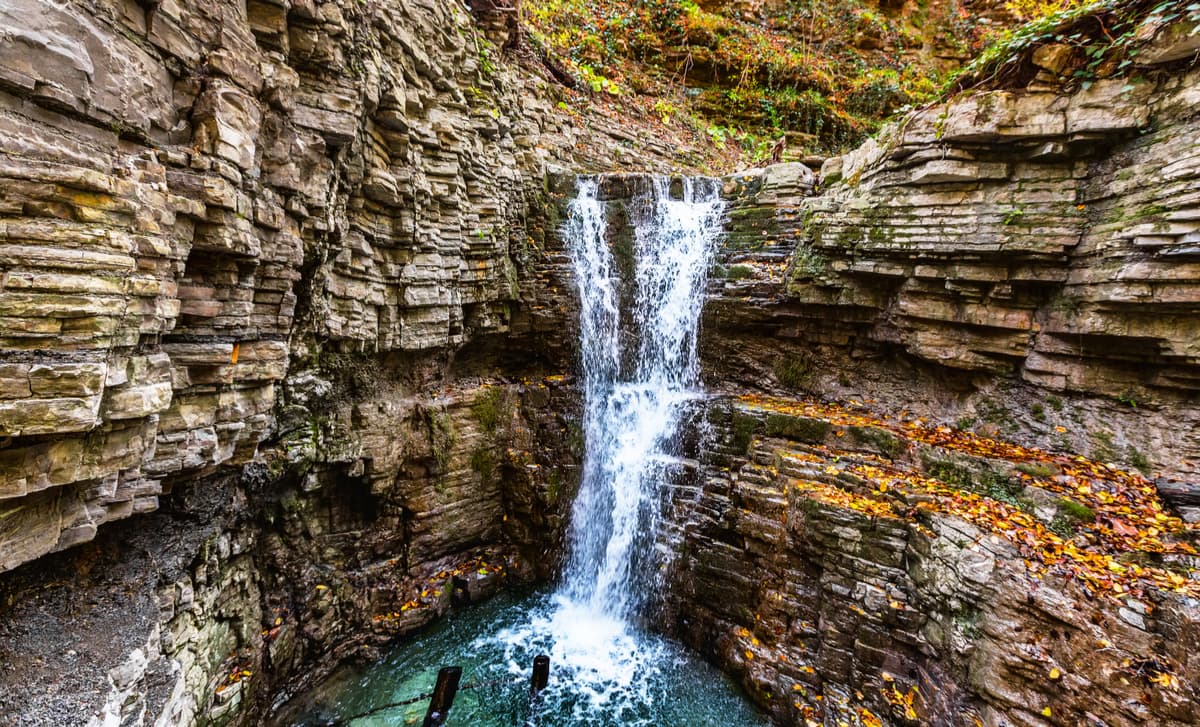
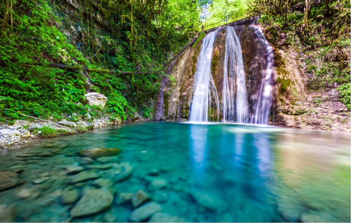
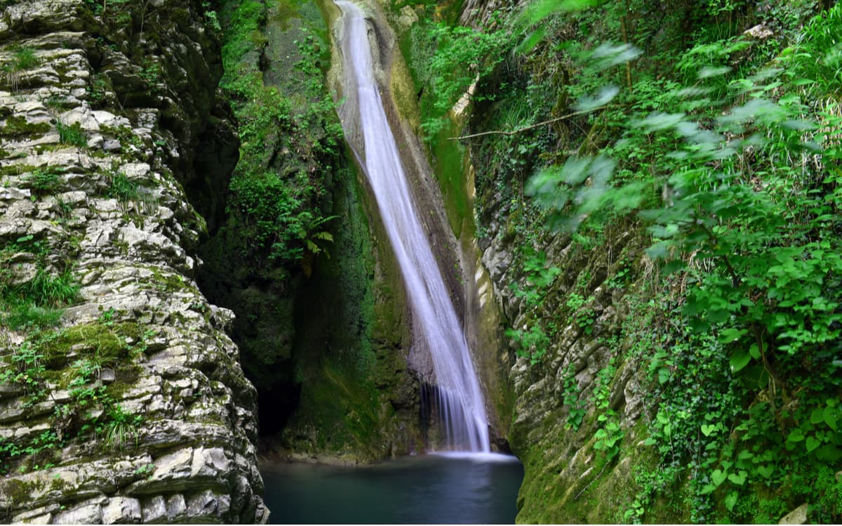
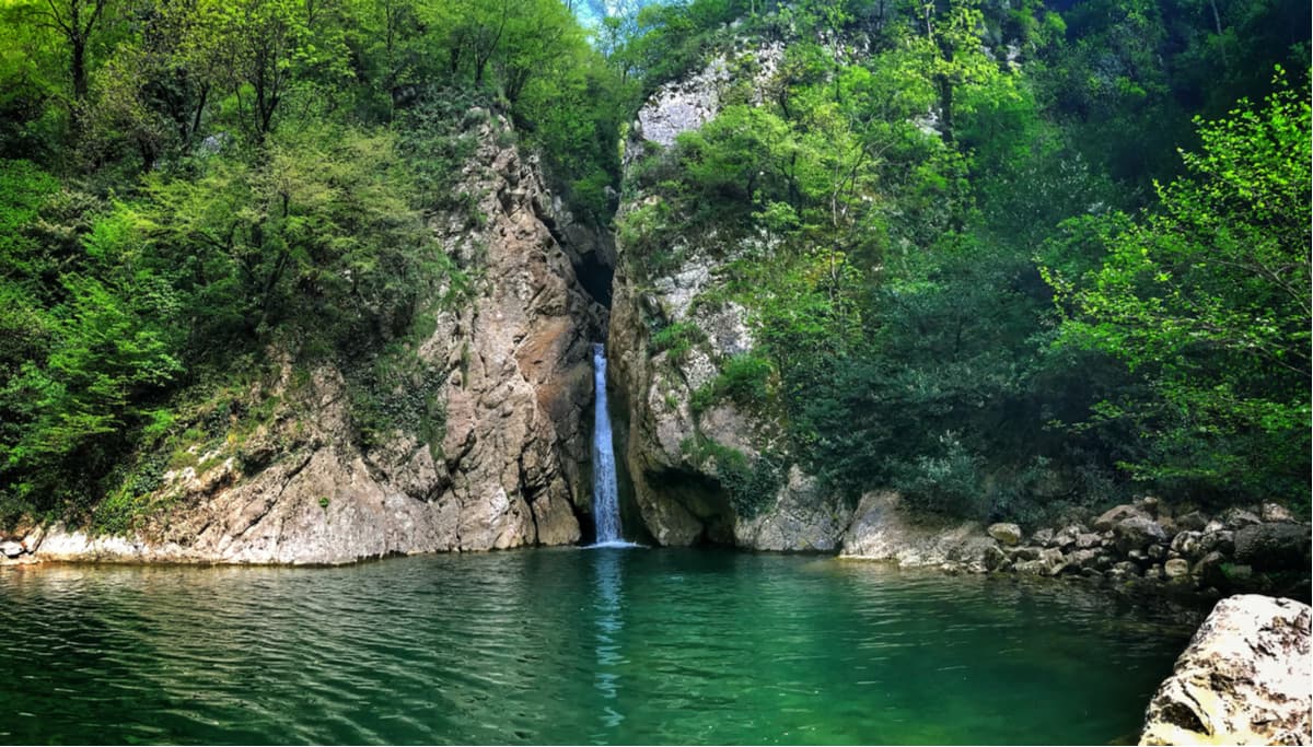
The territory of the park is laced with a network of rivers and streams originating in the mountains and flowing into the Black Sea. The rivers are typically mountainous with rapids, strong currents and splendid landscapes. The water comes mainly from atmospheric precipitation and ground sources. The total number of rivers is 40, the largest of which are the Mzymta, the Shakhe, the Psou, the Ashe, the Psezuapse, and the Sochi. The rivers and streams of the Park have numerous picturesque waterfalls and canyons. They are mainly found in the upper sections of rivers, in minor rivers and their tributaries, and the waterfalls threshold height varies from 2 to 72 m. The highest waterfall Bezymyanniy (72 m) is located on the right tributary of the Psou River. The second highest waterfall Orekhovsky (33 m) is located on the right tributary of the River Sochi. In total, the park has about 70 waterfalls. The territory of the park has long been known for its mineral springs. Their chemical composition is very diverse, e.g. there are hydrogen sulfide, iodine-bromine, radon mineral waters and the much famed Narzan (melted water from the glaciers naturally enriched with vital minerals and salts). Many mineral springs have healing properties and have long been very popular among the locals and guests of the region. The most famous are the hydrogen-sulphide ones in Matsesta, the ones in Chzhizheps and Krasnaya Polyana.
The main treasure of the national park is the mountain forests of unique beauty and richness of vegetation, they occupy 94.1% of the area. There are hundreds of species of different trees growing here. A large area is covered by beech forests, oak groves, and European chestnut woods. Boxwood plantations are very picturesque; boxwood is a rare relic plant, which is found only in southern regions. Many plants growing in the park are listed in the Red Book.
Here in the natural environment live brown bears, roes, forest cats, wolves, martens, red deer, wild oxen aka European buffalos (which used to be referred to as unicorns in the Bible). The world of birds and reptiles is also astounding. Rare fish species can be found in rivers. The main objective of the park is to educate the population and encourage respect for nature and endangered species of animals and birds. The national park is implementing a program to restore the population of the West Asian leopard in the wild. In 2013, for the first time in Russia, a pair of leopards had their offspring in captivity.

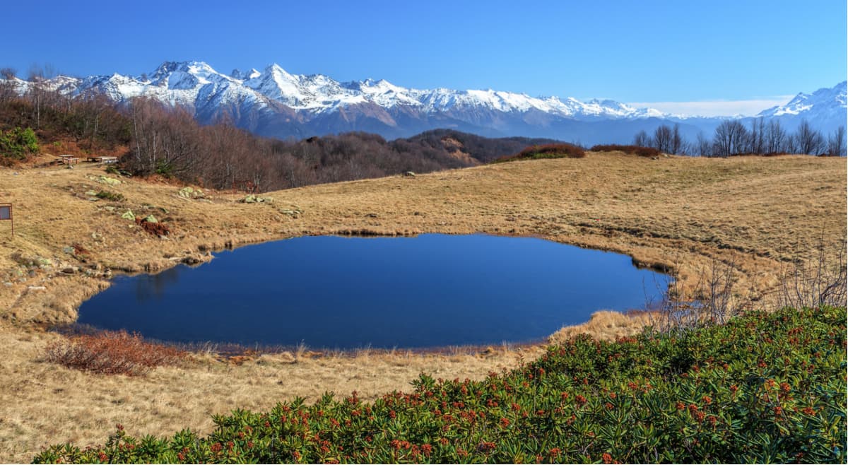
Sochi National Park may well be called a leader in the system of protected areas of the Russian Federation in terms of rich biodiversity, the number of relict and endemic species, the range and variety of landscapes. The subtropical climate of the park is conditioned by its latitude and the influence of the Black Sea and the proximity of the Greater Caucasus Range.
From the coast to the mountains, the average monthly and average annual air temperatures drop by 0.5 C with the elevation gain of every 100 m. Average temperatures in the village of Lazarevskoye (the northern part of the coast) are about 5°C in January, 23°C in July whereas in Sochi (the southern part of the park) they are 7 and 25°C respectively. The absolute minimum temperatures at the coast can drop to -15°C and in the mountains to -30°C.
There are dozens of tourist routes in the National Park, many of which have a long history.
The Aibga Range is a mountain range east of Krasnaya Polyana, near the border with Abkhazia, so it lies partly in the Sochi National Park. It consists of four main peaks: Peak Aibga I (2,391 m), Peak Aibga II (2,450 m), Peak Aibga III (2,462 m) and Peak Black Pyramid. The highest point of the Aibga Range is Stone Pillar Mountain (2,509.7 m) located 5.5 km southeast of Aibga Peak III. The northern slopes at the top of the Aibga Range are steep and precipitous as they are cut into cross-shaped depressions formed by ancient glaciers – the so-called kars. You can perfectly see Black Pyramid Mountain (2,375 m) in all its glory from Krasnaya Polyana. The peak is popular with local climbers due to its regular shape, it somewhat reminds you of Matterhorn.

On the northern slopes of the range, there are ski resorts called the Alpika-Service, Mountain Carousel and Rosa Khutor.
The highest point of the city of Sochi – Mount Agepsta (3,256m) – is located in the southern lateral ridge of the Aibga Range.

The Achishkho Range, or ‘the horse mountains’ as translated from Abkhazian language, in another version it is ‘goat mountains’, is a mountain range in the Western Caucasus, located in the Krasnodar Region of Russia. The major peaks of the range are Achishkho Main (2,391.4 m), 10 km north-west of Krasnaya Polyana; Achishkho I East (2,321.4 m), Achishkho II East (2,363.2 m), Achishkho West (2,317.7 m), and Horse Head (2,159.0 m). The range is composed of clay shale and volcanic tuffaceous stone. The landscape of the ridge is characterized by ancient glacial relief and ridge lakes including karst ones. On the slopes, there are stunning waterfalls, including the cascading Achypsinsky Falls in the upper part of the Achypsa River. The Achishkho slopes are covered with broad-leaved deciduous forests, mainly beech. There are many fir trees in the north and mountain meadows at the tops.
The Achishkho Range is known for its unique microclimate. There used to be the Achishkho weather station on the western shoulder of the range. The range is located in the humid climate zone – the annual precipitation amounts to 3200 mm, the highest in Russia. The thickness of the snow cap reaches 4.8 m. The number of sunny days does not exceed 60-70 days per year.
Trekking to the highest point of the massif – Achishkho Main Peak (2,391.4 m) - is one of the most popular routes in Krasnaya Polyana. There are also dolmens if you are interested in pagan mysteries connected with those table-stone edifices.
The Eagle or White Cliffs is a recreational facility located in the Matsesta Forestry of Sochi National Park in the Khostinsky district of Sochi. Eagle rocks go along the right bank of the Agura River, 2 km from its mouth, near the Agura waterfalls.
Absolutely vertical cliffs rise 125 meters above the river and 379 meters above sea level, they are covered with light limestone and yellow sandstone, hence the name White. There grow pines, oaks, and oriental hornbeams on their summits. In the vicinity of the Eagle Cliffs, there are several karst caves, the largest of which has a depth of 15 metres.
The Pseashkho Range is located in the adjacent Caucasian State Nature Biosphere Reserve and relates to the Greater Caucasus Range. The name of the range can be roughly translated from Adygean language as ‘a mountain of high water’. The Pseashkho technically belongs to the Western Caucasus, it is approximately 20 km from the village of Krasnaya Polyana, in the upper parts of the rivers Urushten, Lesser Laba, Pseashkho. The Pseashkho massif is a complex mountain junction with ridges of different directions and peaks starting from 2500 m. The following peaks are attributed to the range: Northern Pseashkho (3,256.9 m) – the main peak; Southern Pseashkho (3,251.2 m), Uzlovaya (3,004 m), Sakharniy (Sugar) Pseashkho aka Sugar Head (3,188.9 m), Western Pseashkho (2,899.8 m).
The Pseashkho massif features 11 glaciers. The largest of them, the Pseashkho glacier, is the largest glacier in the Krasnodar Region (evidently, not the largest glass field in the world but still an impressive ice body). The glacier is 3 km long and has an area of 1.5 sq. km. To the north of the highest peak of Northern Pseashkho, there is the Mramorny (Marble) glacier, which feeds to the River Mramornaya. Also on the northern slopes is the Kholodny (Cold) glacier, from which the Kholodnaya river originates, it then flows into the Urushten river in a few kilometres. The Pseashkho is popular among tourists and climbers. On some peaks, there are mountaineering routes of complexity categories ranging from 1B to 3B.
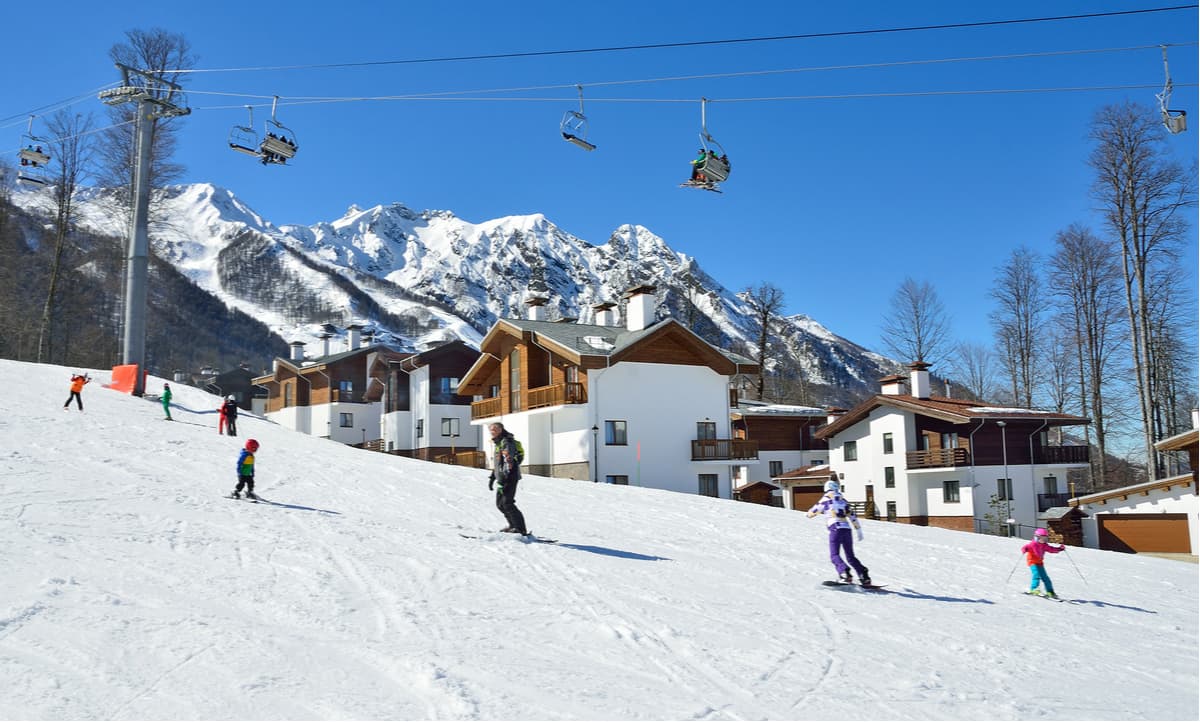
For skiing and snowboarding enthusiasts, there are 3 large ski resorts near Sochi, which are located to the north of Adler District in Krasnaya Polyana area:
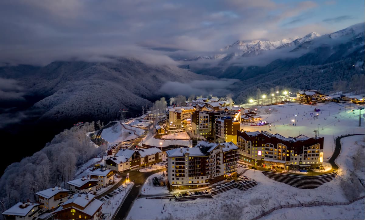
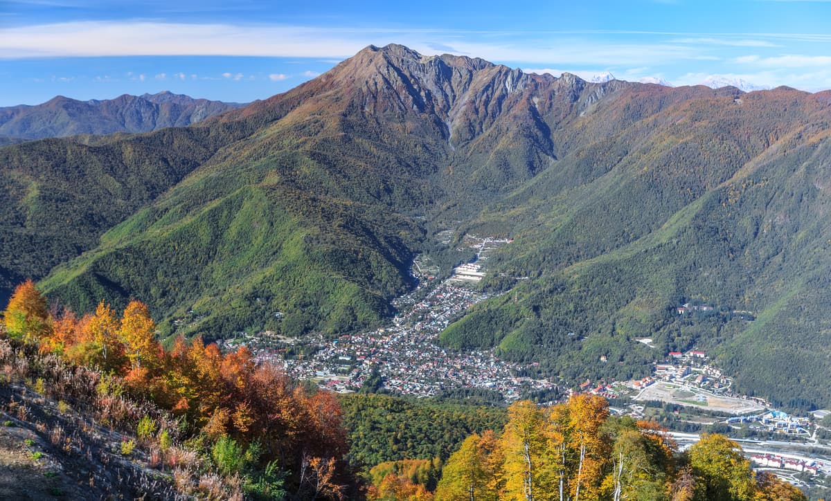
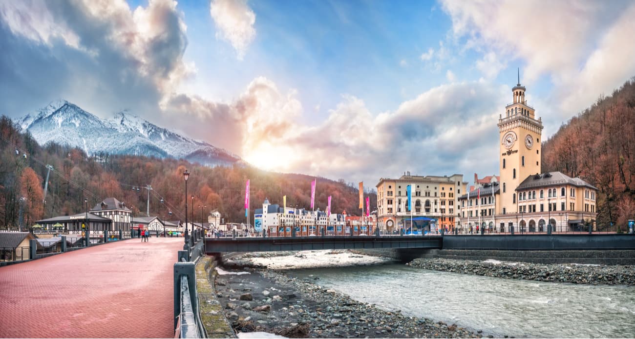
Krasnaya Polyana belongs to the territory of the Sochi National Park. The picturesque village with rich history and unique natural conditions is located in the middle span of the Mzymta River, 38 km from the Black Sea coast at an altitude of about 500 meters above sea level. It is located 64 km south-east of Central Sochi. Krasnaya Polyana is a residential area stretching along the Mzymta River, it is divided into several administrative areas, including Krasnaya Polyana itself (the centre), Esto-Sadok and Rosa Khutor settlements.

The location of the village is really picturesque. The valley of the river Mzymta forms a unique basin surrounded by high mountains: from the north-west, there is Achishkho Mountain and its spurs, from the southeast there is the Aibga Range with its highest Stone Pillar Mountain, which is also the highest observation deck should you wish to look at Krasnaya Polyana from above. The watershed of the Greater Caucasus Range is 15 km north of Krasnaya Polyana.
Krasnaya Polyana seems to be hidden from prying eyes by mighty mountain ranges, it has preserved in its original, truly extraordinary natural environment. Krasnaya Polyana has a mild climate, diverse vegetation, clean mountain air, there are mineral springs nearby and the warm sea.

3d map of Krasnaya Polyana Resort in the PeakVisor app with cable car routes.
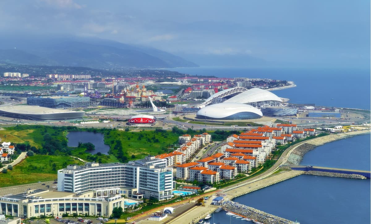
Krasnaya Polyana hosted the XXII Olympic and Paralympic Winter Games in 2014. It was probably the first winter Olympic Games in a subtropical climate. It actually applied as a candidate to host the Winter Olympic Games in 2002 by was bypassed. Still, the Olympic Committee recognized the efforts and the zest and chose Sochi a decade later.
According to the program of the 22nd Winter Olympic Games approved by the IOC, the Krasnaya Polyana cluster accounted for 10 sports, including biathlon, cross-country skiing, mountain skiing, snowboarding, freestyle, luge, bobsleigh, skeleton, ski jumping and Nordic Combined. First of all, this meant that by February 2014, Krasnaya Polyana had provided thousands of guests from all over the world with high quality facilities for holding international competitions: modern sports complexes and equipped ski slopes, comfortable accommodation, logistics and good working conditions for athletes, journalists, various officials, referee panel and thousands of fans.

Thanks to the Olympic movement, there have been built new ski pistes and stations, ski lifts, recreational facilities including an aqua park, a swimming pool, paragliding facilities and many more. Now it is a hype place to go with friends, family and children, everyone can have some fun here. By the way, they even have cybersport club and a chamber of horrors (hopefully not that Panic Room).
Krasnaya Polyana Ski Resort is a multilevel complex on the northern slope of Mount Aibga. The first and the lowest of the three lifts is 540 m above sea level in Esto-Sadok district. Three more stations are located at 960, 1460 and 2200 m respectively. Due to the special location of the mountains, the resort has the longest skiing season – from December to May. In winter, there are 30 kilometres of ski slopes of different difficulty levels, illuminated slopes for evening skiing and artificial snowing.
In winter, there are 13 gondolas, chair and rope-tow lifts. The total capacity is up to 2400 people per hour.
In winter, it specializes in skiing and snowboarding, but life does not stop here with the snow gone. In summer, the Gazprom Ski Resort offers a wind range of touristic services as well. There is a recreation centre, a health centre, a sports and training base. It also has an all-season water park, an entertainment centre, cinemas, and an ice arena.
There are two ski slopes at Alpika, the cosy Laura has the skiing pistes running in the fir forest on the Psekhako plateau. And the legendary Alpika features the ski tracks with a height difference of up to 1,154 meters on the Aibga Range, the first ski resort in Krasnaya Polyana.

In total, the resort has 35 pistes of all levels of difficulty: green, blue, red, and black, you can ski daytime and in the evening. The pistes are wide - up to 66 meters.
There is an opportunity to go cross-country skiing as well. Laura has 12 km of tracks for the biathlon and cross-country skiing. At an altitude of 1500 meters, there is corduroy for skate skiing and track - for the skiing classics.
Rosa Khutor is a year-round mountain resort located on the northern, north-eastern and southern slopes of Mount Aibga. The highest point of Rosa Khutor is 2,509 m above sea level.
The resort has a total of 29 gondolas, chair, rope-tow and conveyor lifts. The resort is home to the Olympic Extreme Park featuring Snowboard Park and Freestyle Center.
There are 102 km of pistes of varying difficulty - from green to black. The altitude difference is 1,534 m. There are 28 ski lifts at the resort which can carry tens of thousands of people per day. The average speed of the main ski lifts is at least 6 m/s. The current system of artificial snowing of the pistes is the largest in Europe. Due to this innovative snow system, the skiing season lasts up to 180 days a year, depending on the piste height.
The ski slopes are located on the northern slopes of the Aibga Range and can simultaneously host competitions in all mountain ski disciplines: downhill riding, slalom, super giant slalom.
Bernard Russi, a famous alpine skier, a 1972 Olympic champion in downhill skiing and an architect of the International Ski Federation (FIS), designed all the ski slopes. According to Jean-Claude Killy, many-time Olympic and world champion, an IOC representative, the downhill piste of Rosa Khutor is the best in the world. The pistes have also been positively assessed by the outstanding American skier Bode Miller.
The resort has an indoor ice palace with a full-sized ice arena and stands for 438 seats.
The lifts operate at the resort in summer as well, providing mountain walks including climbing the highest observation deck in Sochi – the top of the Stone Pillar 2,509 meters high. In May 2018, the beach of the Rosa Khutor resort was awarded a blue flag certificate of quality.
Check the Sochi ski resorts map on the larger Krasnodar Krai and Russia ski resorts map in the World Mountain Lifts section of the site. It includes information about open ski lifts / slopes in Sochi in real-time with opening dates and hours. There are also year-round cable cars, funiculars, cog railways, aerial tramways, and all other types of mountain lifts.
Climbing Bzerpi Peak (2,483m) is one of the most popular day hikes suitable for tourists of all levels. It starts from the Alpika-Service rope station at Krasnaya Polyana. The cable car 3S can climb to a height of 1,660 meters from where a leisurely ascent to the alpine meadows of Bzerpi takes only 2-2.5 hours. The Bzerpi cornice (kind of a ledge rock with the ground rising on one side and falling away on the other) is about 2,100 meters above sea level. From the cornice, there is a beautiful view of the Krasnaya Polyana and majestic mountains. Then you can climb Bzerpi Peak (2,482 m).
The top of Stone Pillar (2,509 m) is the most accessible mountain in the vicinity of Krasnaya Polyana. The reason for this accessibility is that just one kilometer from the top there is the upper station of the Rosa Khutor cable car. From the top, there is a magnificent 360-degree panorama of the Western Caucasus mountains, and if you are lucky and there is no haze, you can even see the Black Sea on the horizon.
Despite the hostile outlook as seen from Krasnaya Polyana, absolutely anyone, even not the most athletic person, can climb Stone Pillar. From the cableway station to the top, there is an excellent trail (in fact, a dirt road), marked with signs. The second part of the ascent can be done by another chair lift which leads almost directly to the top. The length of the trail is 5 km. The altitude gain on the route is 450 m. However, it is not always possible to climb Stone Pillar. The route is closed In winter and spring time due to the danger of avalanches and breaks of snow-covered cornices.
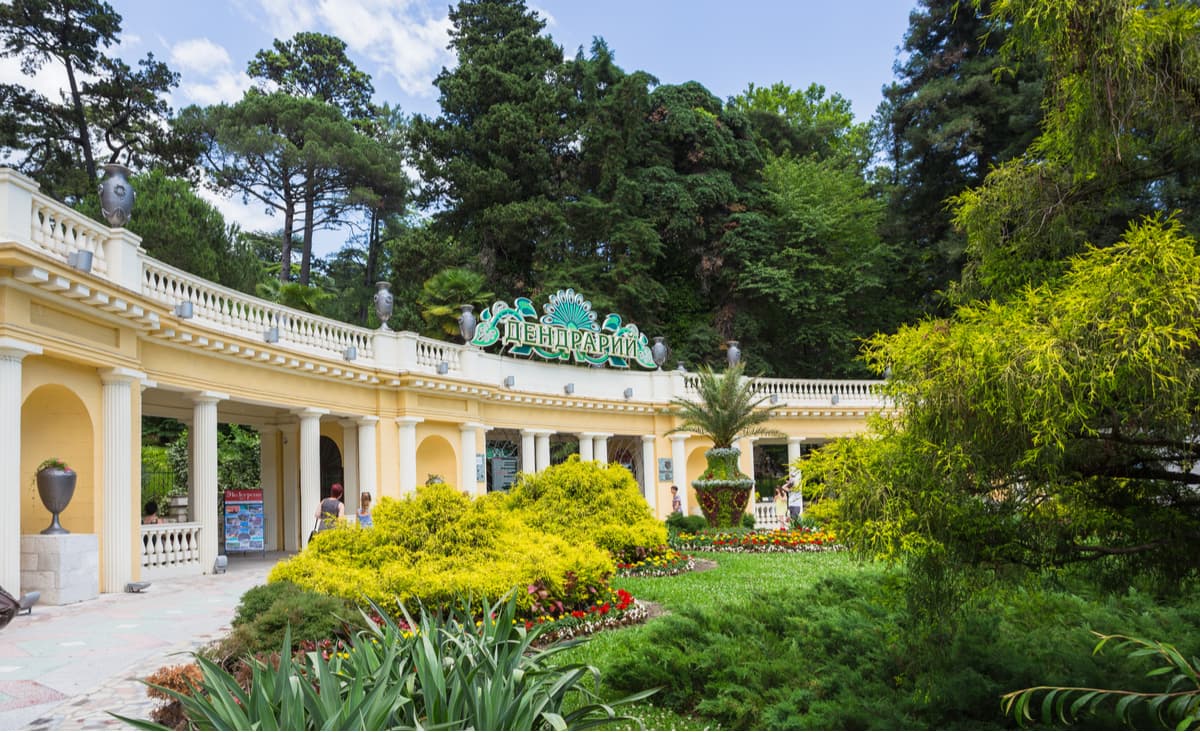
The Arboretum Park is rightfully considered one of the iconic places of Sochi, it is often called the ‘green heart of the resort’, which is quite justified. The park can boast of a unique collection of subtropical flora and fauna, it is a pinnacle of garden and park art. The area of 46.4 hectares features trees and shrubs brought from all over the world. To date, the living collection of the park has more than 1800 species, including 66 species of oaks, 74 pines, 54 palms and a huge number of rare exotic species.
The park is located on both sides of Kurortny Avenue in Sochi. Apart from the historic center in the upper part of the Arboretum, there are landscape and geographic sections that represent subtropical forests of East Asia, North America, Australia and New Zealand, and, of course, the endemic Caucasian flora.
Once you are in the park, visit the sequoia grove where the most giant long-living trees on the planet flourish. They can reach a height of 100 m and more. It takes a couple of thousand years for the trunks to grow to their giant size. Palms, oaks, eucalyptus and conifers also grow in the park.
The navigation in the Arboretum is easy, firstly because many of the green exhibits are equipped with tables featuring text information and secondly there is a free mobile application called Arboretum Guide, just scan the QR codes and learn what you are looking at. The app also offers funny photos with virtual animal projections using augmented reality technology built into the functionality of the app.
The park is an important experimental base of the Research Institute of Mountain Horticulture and Forest Ecology. There have been many experiments with rare forest and ornamental exotic plants which now make up collections of botanical gardens in the Carpathians, Central Asia, Romania, the Czech Republic and many other countries. Every year more than 1000 samples of seeds of rare plants are sent from the Arboretum to different institutions of the world. The place that benefits most from those experiments is Sochi itself, the plants, even the most exotic ones, used for the city landscape design are usually grown here.
The Akhun is a mountain massif located between the Khosta and Agura rivers in the Khostinsky district of Sochi, which is relatively close to the city centre. The highest point of the massif is Mount Big Akhun, it can be perfectly seen from the bypass road towards Adler. From there, you can see that the shape of the mountain is visually reminiscent of a volcano, but it is only an external similarity.
The Akhun Mountain Ridge is a unique place. Firstly, this 5-kilometre ridge is located close to the sea. Secondly, you can find two seemingly conflicting types of forest here: beech and hornbeam woods from the south and north are mixed with broad-leaved Colchians subtropics from the east and west. There are mineral springs found in this relatively small area (a total area of the range is about 2,000 hectares). There are over 200 species of plants here, but the real gem is the Caucasian lily, first discovered on these steep limestone slopes. There are also fungi, adder’s ferm, orchids and other rare plant species. The animal world is also particularly diverse. Almost all species of animals and birds who prefer the lowland forests of the Northwest Caucasus live in this part of the park. Even a bear can be spotted occasionally.
Here, on the slopes of the Akhun, you can explore about 20 caves, see the ruins of ancient fortresses, dig out fragments of ancient pottery.
The Akhun View Tower itself is not that old, it is less than a hundred years old. It was built in 1936 by order of Joseph Stalin. Thousands of workers toiled there – everybody was trying to outdo themselves: quarry workers, masons, carpenters. As a result, it took just 108 days to erect the tower from the local white limestone, and 122 days to lay a 12-kilometer road. The architect described his creation as "a construction in the Romanesque style, with a transition to the early Italian". Every detail had been meticulously calculated here. The height of the Tower is not that impressive, still it does not allow growing trees to cover the picturesque panoramas.
The Psydakh and Shapsug are two waterfalls located in the mountains of Lazarevsky district. To get to the recreational facility of the Sochi National Park, you need to turn from the main road (Sochi-Lazarevskoe) towards the village of Kalezh. Then go to the parking lot by the Ashee River, from there you can walk to the waterfalls. It will take about half an hour to get there. The walk will not be tiresome, there are stunning views around: majestic mountains tower over the lush green of a dense forest, you can see some rocks exposed intermittently, which from afar resembles a huge layer cake.
The Psydakh Falls is not visible from afar as it is hidden in the rocks and green forests. The approach to the waterfall is equipped with a wooden staircase with railings and observation platforms, which offer a beautiful view of the waterfall and the Ashee River valley.
The Psydakh translates as "Beautiful Water", it consists of three cascades which are located size-wise, the lesser cascades are more accessible than the bigger ones. At the very bottom, you see the first cascade, which is only a couple of meters high. A little higher is the second cascade, which is about 5 meters high. But the most beautiful, majestic part of the waterfall opens up to those who climb to the very top via wooden bridges and stairs. From a height of twenty meters, streams of water rush down in two cascades. The upper cascade falls into a narrow, blade-shaped crevice and lands in a small round lake.
One of the unofficial, folk names of this waterfall is Bride's Falls. It's nicknamed because its sparkling splashes resemble the bride's wedding veil.
The Shapsug Falls is about half a kilometer above the Ashee River. The Shapsug is more powerful and impressive than the Psydakh. The name Shapsug is much easier and more understandable - it is named in honor of once numerous tribe people who lived in this area since ancient times.
The height of the Shapsug Falls is about 50 meters, it consists of three cascades, you can climb to each of them via a special wooden staircase with railing. The climbing steps are quite steep, so you should be able to step up high in those super comfortable shoes. There are also several viewing platforms on this ascent, they offer stunning views of the Ashee valley and the waterfall itself with its picturesque steps. Here, just next to the waterfall, there is a thirty-meter suspension bridge over the mountain river.
Mount Snake (Zmeika) has a fast river, also called the Snake, rushing down the mountain slopes. The mischievous serpent runs along steep banks, spilling over into troughs and stony plains, overcoming small rapids and rushing from steep rocks. The cascades of beautiful waterfalls create ethereal landscapes. Selfish and unpredictable as any mountain river, it can in a matter of minutes turn into a roaring deadly gush sweeping away everything in its path. That is why the first settlers of these places nicknamed the river Savage. It was a long time ago, but the character of the river remained the same throughout all those years and frequently reminds of its first generic name.
The waterfall consists of seven cascades, climbing to them is not easy because the path runs along steep mountain trails. Yet, the effort is well worth it, every step takes you closer to breath-taking views and picturesque landscapes. The first waterfall is ten meters high, it is quite powerful and falls into a small swimming pool formed at its foot. The third waterfall is a mighty straight-line nine-meter stream which rushes into the bowl beneath it creating a vicious boiling turmoil of water. Closer to the middle of that natural bowl, the water calms down and near the shore it becomes almost still and transparent.
The fourth cascade may seem less impressive to someone since the height is relatively small, only about one and a half meters. But here the stream is beautifully divided into two parts and flows on both sides of a huge stone block into the bluish sparkling pool. The walk to it is quite comfy as the path mostly runs on an almost even rocky surface. Prepare for your jaw to drop once you get farther. The fifth cascade drops into a pool of a right rectangular shape chiseled by eons of water falling from the 3-meter height. You can get to the waterfall by a wooden ladder and descend from there to the equipped path. Once up at the cascade, take a look down the river, you will see that this spot is a logical continuation of the previous. The River Snake flows along a deep furrow laid by somewhat rectangular tiles of rock. Such a picturesque relief is nothing but the result of hard work. Billions of jets of the Snake washed their way through in the layers of rock forming countless labyrinths, and the work is not finished yet.
The Nadzhigo canyons and falls are one of the most picturesque places in Sochi, they are actually the most western falls and are closer to Tuapse than Sochi. Huge stone canyons are cut by the Makopse River in the rocks, there are many springs with crystal clear water and magnificent waterfalls. The waterfalls have interesting names: Dysheps, Myzheps, Tyzhineps. If these names are translated into Russian, we get the names "Golden Water", "Stone Water", and "Silver Water".
The length of the walking section of the road is about 700 meters. Drive from Tuapse to Nadzhigo village (called ‘aul Nadzhigo’ by the locals). Hiking trails start from the village, you will see the falls in 2 km or so. The Nadzhigo Falls are surrounded by a quiet forest, dominated by Colchian vegetation, you will also see the representatives of rare flora species listed in the Red Book of Russia and the Krasnodar Region.
The falls are a sight to behold and definitely a go-to place for a photographer. Glittering with mischievous sparks, the stream picturesquely descends down a scatter of colored stones. The highest waterfall is 35 meters, the water falls down a stunning high rock section. Then there is a 32-meter waterfall and some smaller ones ranging between 5 to 10 meters.
The 33 Waterfalls are located in the Golovinskoye Forestry in the Sochi National Park. This is the place frequented by city visitors and residents alike. This fairy-tale-like place is quite far away from any civilization. Are there really 33 falls? Not exactly, it is more a conditional figure than a real one, but still, the waterfalls are plenty. In fact, walking along the route, you can see 13 large rapids formed by the streams of the Dzhegosh tributary.
The first and the highest waterfall (over 10 meters) is also the noisiest and the most impressive. All subsequent cascades are approximately 1.5 to 5 meters high. Almost at the farthest point of the well-equipped route, there is the second highest waterfall, it is the thirteenth and is about 7 meters high.
The 33 Falls are located on the Dzhegosh stream, a tributary of the mountain river Shakhe. You can get to the waterfalls by the main highway Sochi-Lazarevskoe, go to the village Golovinka, then turn to aul Bolshoy Kitchmai. Then drive seven more kilometers along the Shakhe River on an asphalt road and about one and a half kilometers on a dirt road.
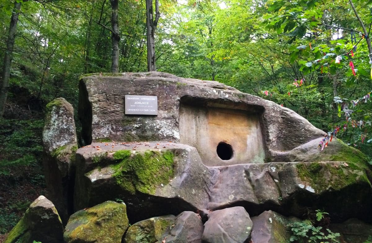
In the Lazarevskoe district, 200 meters from the highway Novorossiysk-Sochi, near the village of Volkonka, there is a place which many professional travelers, scientists, historians, as well as esotericists, occultists and just lovers of mysteries and legends seek to visit. This place is next to the spring of the mineral sulphurated hydrogen water, in the gorge along which runs the mountainous rocky river Godlik. That's where the famous Volkonsky dolmen is located.
In translation from Breton language dolmen means "a stone table" (taol maen). This is the word to call structures reminding of a table shape and used for funeral, cult, ritual purposes. Ancient megaliths are also made from stone slabs mounted on the same stone supports.
The Volkonsky dolmen is the only dolmen monolith in the Caucasus. It is a unique monument of megalithic culture. Not only nature and time shaped the appearance of this stone block. The material from which the dolmen is made is sandstone. The size of the dolmen is impressive: its height is up to 6 meters, width is 7.5 m., the inside cut of a spacious chamber is 1.6 m x 1.9 m and it can accommodate several people, in case they manage to squeeze through a small round hole on the outer wall. Inside the walls and the ceiling are round, so the division is kind of arbitrary, but the floor is flat and there is a funnel hole made presumably for the flow of water or other liquids. On the roof of the dolmen, there is also a hollow of about 60 cm in diameter.
The assumptions around dolmens sometimes beat the wildest imagination. After all, those edifices date eons back and their creators/users are long gone. Yet, many researchers believe that they were built at the same time when the famous Egyptian pyramids were built.

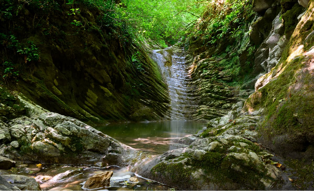
The Svirskoye gorge in the Sochi National Park in the Lazarevskoye District is a picturesque canyon formed by the Svir River. As usual, the river has several waterfalls that are majestic and enigmatic. You feel even more so when on your way the canyon ends abruptly with a dead wall from which rushes down the first Svirskiy Falls, all in foam and splashes.
A canyon leads to the first waterfall. Even on the hottest summer days, direct sun rays do not penetrate down to the bottom of the canyon, which makes the colors appear brighter and the air fresher. The locals believe that if you stand under the jets of the first waterfall, you redeem your sins as if they are washed with holy water. So the whole canyon is also called sacred.
The first and second waterfalls are only 800 meters apart, this distance is easy to cover. In order to get to the second waterfall, you have to take a dirt road that runs above the river. The second waterfall opens up suddenly. Its height is about 9 meters.
In the vicinity of Lazarevskoye you can take a small but fascinating walk to the Crab Gorge. It is called this way because there are freshwater crabs in this mountain creek, which speaks of the purity of the water and the good ecology. A well-kept forest path and wonderful views along the way will make your journey unforgettable. You will see the Mermaid Laver and Adam's Laver, the Karst Canyon and the Wish Canyon. And at the end of the trip, you will see the main local wonder: the Crab Canyon, which is about 10 meters deep. Here the creek forms a cascade of small waterfalls and water bowls where you can swim.
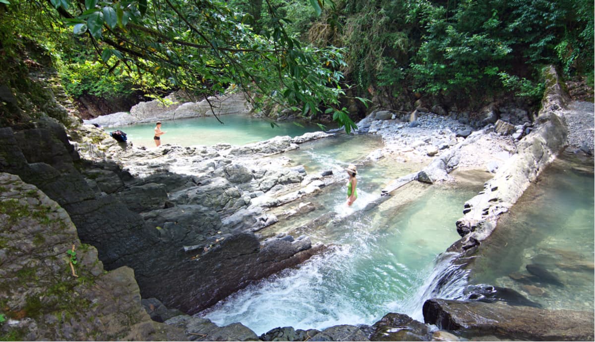
The Dagomysskiye Koryta aka Troughs is a picturesque place located in the middle reaches of the West Dagomys River, 9 km from the village of Dagomys.
The bed of the river in this place is divided into separate cells by vertical rock layers of marlstone and clay shales of greenish-brownish-yellowish colors, those cells are located perpendicular to the channel. The river seems blocked by plates, each cell is a kind of a separate trough. Over time, a whole cascade of reservoirs was formed downstream. From all sides, the troughs are framed by the emerald green of chestnuts, beeches, hornbeams and boxwood. Tea plantations can be seen upstream in the surrounding hills. It was in the area of Dagomys near the Troughs that the first Russian tea plantation was established in the village of Solokh-Aul.
The Wonder-Beauty (Chudo-Krasotka) Gorge is a unique blend of natural landscape formed by forest massifs and particular geological features. The river with a surprising name Wonder-Beauty (Chudo-Krasotka) flows through the gorge and forms small waterfalls on its rapids. The rhythmic murmur of water, gentle sputter of the waterfall, fresh forest air rich in ozone – everything creates the ambience fit for healthy rest boosting your vitality and good mood.
The length of the route is 5 km in both directions. There are cafes, souvenir shops, meadows for recreation. The gorge is located on the highway Novorossiysk-Batumi. You can get there from Lazarevskoye by bus routes № 68,72,147, a request stop is called Samshitovoe Gorge, notify the bus driver in advance you wish to get off there.
The waterfall is located at the exit of the highway Adler - Krasnaya Polyana, just behind the village of Chvizhepse, 6 km from the village of Krasnaya Polyana. The source of Girl's Tears is a small stream. It comes down from a 13-meter high cliff. The stream falls splashing onto the rocks and boulders beneath, and then flows towards the Mzymty River, which later flows into the Black Sea.
It is noteworthy to mention the so-called dry season from May to October when the streams are no longer as powerful and full due to the dry and hot weather conditions in southern Russia at this time of year. In some years, most part of the waterfall will dry out for several months. At the same time, thin streams of the dripping water still continue dropping from the rock.

In the Kuapse River valley, there is a picturesque spot called the Berendeevo Kingdom. It is a place with a magnificent panorama of mountains and rocks, waterfalls and mountain folds. Two large waterfalls located here are the Kupalo and the Nameless. From these waterfalls the walking path starts its sharp ascend up, it then passes through the bridge Mezgirya, and gets you to the fantastic valley which is crowned with the most beautiful waterfall – the Berendey’s Beard.
Once you go over the hanging bridge, you will get to the hospitable Berendey’s Kingdom, sit on the Tzar Berendey’s throne and dine at a cozy cafe. Farther along a well-equipped trail (900 meters long, 100 meters elevation gain), you will see seven waterfalls from 12 to 30 meters high, the altar of the goddess Lada (she is the patroness of people in love and families), picturesque karsts, a variety of ferns, mosses, the Lel creek and Lake Happiness.
The excursion route to the Agura River gorge is the oldest in the park. The trail was laid back in 1911 by enthusiasts of the mountain club which was organized by Vasily Konstantinovich Konstantinov – an engineer who led the construction of the road to Krasnaya Polyana and the second section of the Black Sea railway at the turn of the 20th century.
The path leading to the first 30-meter-high waterfall is carved in the rock. The waterfall consists of two cascades of 12 and 18 meters, the jets of which fall at an angle to each other. A bit higher above, there are two other waterfalls, smaller in height but no less beautiful. The second ‘big’ waterfall is 21 meters high and splatters into many jets. The height of the third waterfall is 23 meters.
The Agur Falls are located 3 km from Sputnik place, the access to the waterfalls is possible only by a hiking trail (2.5 km).
The route called the Khmelevskie lakes is 3.3 km long and runs through the territory of Krasnopolyanskoye Forestry. You can get there by a timber road, just make sure you drive a jeep or similar 4-wheeler. The road is 11 km long and 3 to 4 meters wide. There are 7 bivouac parking places along the road. You can stop, let other transport pass by, relax and admire the surrounding nature.
The Khmelevskie lakes are located 6 km east of Mount Achishkho on the leveled ridge surface of the Achishkho Range. There are 4 relatively large, heavily overgrown lakes: the Big, the Eastern, the Southern and the Western, and several smaller ponds and swamps. The Khmelevskie lakes are located almost exactly to the north of Krasnaya Polyana, 4 kilometres from the centre of the settlement. The Khmelevskie lakes are at 1,822 m a.s.l., thus the panoramas from them are truly beautiful, you can see the Achishkho, the Fisht, the Chugush, the Aibga and other mountain ranges.
By plane to Sochi (Adler) airport, by rail or road to Lazarevskoe, Sochi, Adler.
Sochi is the largest resort city in Russia, an important transport hub, as well as a major economic and cultural center of the Russian Black Sea coast. It is also informally called the capital of summer, southern and resort life of Russia. In 2012, Forbes Magazine accredited Sochi as the best city to do business in the country.
In 2007, Sochi was elected the capital of the 22nd Winter Olympic Games held in 2014. On September 15, 2009 Sochi joined the World Union of Olympic Cities. During the preparation for the Olympics, 500 billion rubles were spent on the development of the city and its infrastructure.
In 2018, the city hosted matches of the World Football Championship.
The most important factors that attract tourists to Sochi are warm subtropical climate, lush sea, abundant mineral springs, close proximity to the mountains, well-developed tourism and recreational infrastructure. The virgin Colchian forests of the Western Caucasus on the territory of the city (the Caucasus State Biosphere Reserve) are included in the UNESCO World Heritage List.
Of the 3502 sq. km. total area of the resort city, 81% are specially protected areas and sites, e.g. the Caucasus State Biosphere Reserve, the Sochi All-Republican State Nature Reserve, and the Sochi National Park. More than 80% of the city's territory is covered by vegetation represented by a wide range of species that can grow at different altitudes. You can see subtropical forests and glacial highlands vegetation on a single day.
Sochi is an all-season resort, there are 705 classified accommodation facilities on its territory, among them are 66 health resorts, 20 spas and recreation centres, 1 balneary centre and 618 hotels featuring 42 new hotels managed by 12 world leading hotel chains, including Swissotel, Rezidor, Hyatt, Accor, Marriott, Rixos, etc. Among them are resorts, which are famous in their own right, i.e. Matsesta, Khosta, Krasnaya Polyana, Dagomys, and Adler. There are 183 beach areas, more than 100 tourist facilities, and about 70 tour operators.


