
Scan the QR code and open PeakVisor on your phone
Budapest is home to 71 named mountains. The highest is János-hegy at 527 m.
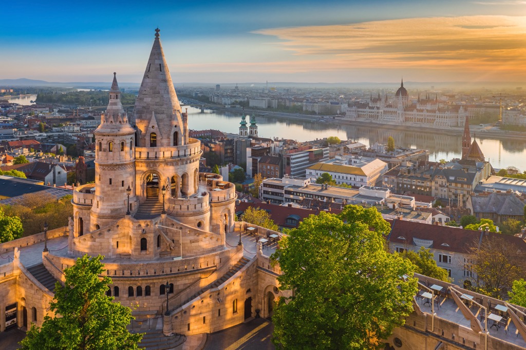
Budapest is the largest city of Hungary in Central Europe and one of the greatest European capitals in general. The main feature of the Budapest mountains is Gellért-hegy or Gellért Hill (235 m / 771 ft). It's not the tallest, but it is centrally located and offers the best panoramic view of the city, the Danube River, and several bridges crossing it. As for the Budapest highest mountain, it is János-hegy (528 m / 1,732 ft), which is known for the impressive Elizabeth Lookout on the top, which can be reached by Libegő cable car, but even better on foot by one of the marked hiking trails. The most prominent mountain is Hármashatár-hegy (495 m / 1,624 ft) with 236 m (774 ft) of prominence. In total there are 71 named mountains in Budapest.
The origin of the name of the city of Budapest is one of the major such stories in Europe, if not in the world in itself—and a very simple one at that. The city is a result of the merger of the two smaller original settlements, Buda and Pest, on either side of the Danube River, so remember it right away: Buda is the western part, and Pest is eastern. But the city was originally called the other way around, Pest-Buda, most likely because of the sunrise in the east. Or Pest was a larger settlement. But in reverse order, the two words more naturally merge into one, so this version has settled.
What the words themselves mean is difficult to say. Most likely, 'buda' means 'house, any structure or settlement' and 'pest' means 'furnace, dwelling'. What is certain is that these words are of Slavic origin. The Slavs lived in this area before the arrival of the Hungarians. Even earlier it was one of the northernmost and easternmost Roman colonies called Pannonia.

Budapest is a city and at the same time a county, which is located in the region of Central Hungary, whose name speaks for itself. In addition to it, the region also includes Pest County, which borrowed the name of the eastern part of the city. It surrounds Budapest on all sides and is essentially Central Hungary. It borders the regions of Northern Hungary (Észak-Magyarország) and the Northern Great Plain (Észak-Alföld) to the east, the Southern Great Plain (Dél-Alföld) to the south, and Central Transdanubia (Közép-Dunántúl) to the west.
The city itself, as has already become clear, lies on both sides of the Danube River. If you look at the flow of the river, Buda is on the right bank and Pest is on the left, which is the opposite of the direction west-east. It is the second largest city on the river after neighboring Vienna, the capital of Austria, only slightly behind it. The cities' populations are 1.9 and 1.7 million people, respectively. In terms of it, Budapest is also 9th in the top 10 largest cities in Europe.
Internally, it consists of 23 districts in Roman numerals, where I is Buda proper, but Pest is V, as II, III, and IV are located north of Buda. So I and V make up the center of the city.
Budapest is a city with two opposite faces: Buda, its right (following the Danube River) western side is hilly, and Pest, its left eastern side, is flat.
So the hills of Budapest are named Buda Hills or Buda Mountains. But we’ll talk more about them right next.
The Pest Plain is a microscopic part of the Great Hungarian Plain (that’s how big it is If you compare them), whose boundary is easily traced thanks to the arc of the Carpathian Mountains, which surround it from the east, as well as the Dinaric Alps to the south and southwest, and the Alps to the east. Together with the Little Hungarian Plain to the north, it is also known as the Carpathian Basin or Pannonian Basin (remember it was part of the Roman Empire?) of the same Danube River. To complete the picture of the main landscape of Central Europe, to the north of the plain are the Bohemian Ranges in Czechia.
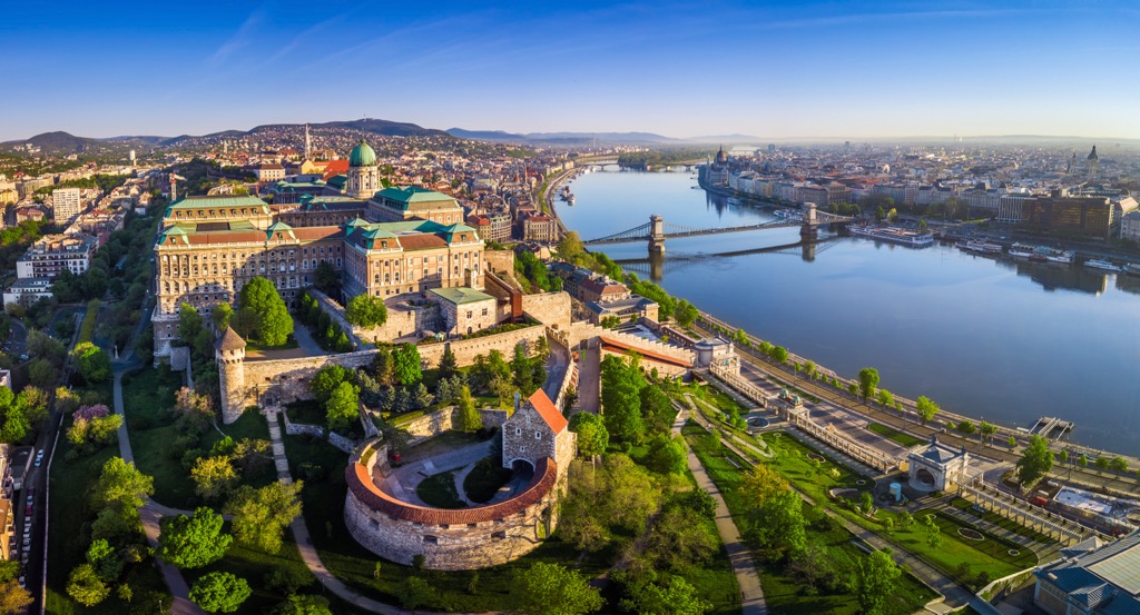
But we need to go back to the center of Budapest because it is also known for the islands in the Danube River. There are more than seven in total, the two largest of which are Margit-sziget and Óbudai-sziget to the north of the center. There are also two huge parks, where you can go for a walk after walking across one of Budapest’s several famous bridges crossing the river (of course).
Another feature of Budapest’s landscape that cannot be overlooked is the fact that the city is also located on a tectonic fault, which explains a large number of thermal springs on its territory and even more in its surroundings. Budapest’s thermal baths make the city famous throughout Europe and the world. I mean, there are literally dozens of outdoor hot water pools right in the city center. They are also known as the Turkish baths due to the fact that the city was also part of the Ottoman Empire. The largest and most famous of them is Széchenyi Baths—no, it is just huge. Smaller ones are Gellért Baths, Rudas Baths, Lukács Baths, Király Baths, Veli Bej Baths, Dandár Baths, and many others. They are also on the Margit-sziget island—Palatinus Strand Baths.

So the mountains of Budapest are called the Buda Hills or the Buda Mountains (Budai Hegyek in Hungarian). They are a small mountain range to the west and northwest of the Danube River and have more than 60 peaks. These mountains are part of the larger Dunazug Mountains along with the Gerecse Mountains and Pilis Mountains to the north of them.
In turn, the Dunazug Mountains are part of the long internal mountain range, the Transdanubian Mountains, which stretches from the capital of Hungary to Balaton Lake, the largest in the country, in the direction from north-east to south-west or vice versa, separating the Little Hungarian Plain and the Great Hungarian Plain. Along with the Dunazug Mountains in the same range are also three other ranges: Bakony above the Balaton, Vértes Mountains, and Velence Hills.
It is important to note that the Transdanubian Mountains formally do not belong to the Carpathian Mountains but are often referred to as part of them in various sources.
Geologically, all these mountains, including the Buda Mountains, are mostly made up of sedimentary rocks, mainly limestone, some dolomite, and others, which were formed mostly in the Triassic period, like the better-known Dolomites in Italy and Austria.

As for the most important individual peaks of the Budapest Mountains, it is worth mentioning at least five of them, namely:

If you go further north of the Pilis Mountains, you will find another small range, the Visegrád Mountains, which are part of the North Hungarian Mountains, the southernmost part of the Western Inner Caucasus Mountains, one of the eight major ranges or parts into which this mountain system is divided.
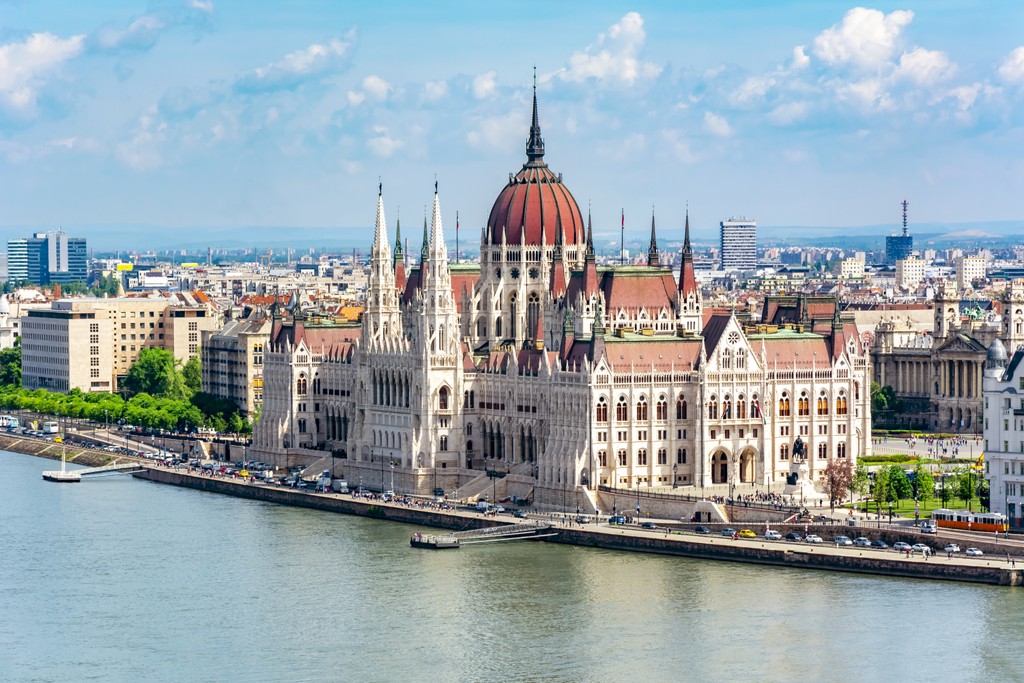
To conclude this part of the guide, it should also be noted that the right eastern side of the Danube River is not entirely flat after all, but has some hills as well. There are about a dozen of them, but these three should be noted in the first place: Nagy-szikla (115 m / 377 ft), Mimóza-domb (115 m / 377 ft), and Királydomb (137 m / 449 ft). They are located in Budapest City Park (Városliget), the main one on the eastern side of the city, where you can also find the city’s largest Széchenyi Thermal Baths.
In the City Park, you can also take an air balloon flight to see the whole city from a bird’s eye view, including all the Budapest mountains.
Budapest is a very green city, a significant part of which (83 sq km / 32 sq mi out of 525 sq km / 203 sq mi or about 1/4) are parks and other natural areas. The main and largest of these areas is Duna-Ipoly Nemzeti National Park, one of 10 national parks of Hungary, which is located north of the city in Pest County and consisting of two parts, Duna-Ipoly and Nemzeti, also on either side of the Danube River, which flows west to east here.
Formally, as a territory, it covers only the Pilis Mountains, Visegrád Mountains, and Börzsöny Hills, but as an organization, it also manages a huge number of smaller natural terrains scattered literally around the whole of Budapest, namely eight protected landscape areas and 13 nature reserves.

Of the separate natural areas, not related to the park territorially or administratively, is above all Normafa Park, formed around the highest mountain of the Buda Mountains, János-hegy, which can be hiked on a circular trail of 6 km (mil). In addition to Elizabeth Lookout and Libegő cable car, there are many other attractions: for example, Tündér-Szikla (“Fairy Rock”), an unusual rocky outcrop that went out from the slopes of Tündér-hegy ("Fairy Hill") of 402 m (1,318 ft).
Another great destination for hiking in these and other natural areas of Budapest are the karst caves (remember their limestone nature?) such as Pál-völgyi Cave and Szemlő-hegyi Cave, and many others.
For family hiking with children, I also recommend visiting Budakeszi Wildlife Park (Budakeszi Vadaspark) with bears, wolves, lynxes, and other animals, located near the town of Budakeszi between Normafa Park and Budai Landscape Protection Area.
Budapest, like Hungary as a whole, is not a major ski destination in Europe. The largest resort in the country, Síaréna Vibe Park, located southwest of the capital above Balaton Lake, has only 7.7 km (4.7 mi) of slopes and 8 ski lifts.
Consequently, the nearest major resorts to Budapest are in the surrounding countries: Austria, Slovenia, Croatia, Bosnia and Herzegovina, Serbia, Romania, and Slovakia.
Check these and other countries' ski maps in the World Mountain Lifts section of the site. It includes information about open ski lifts / slopes in Europe and other parts of the world in real-time with opening dates and hours. There are also year-round cable cars, funiculars, cog railways, aerial tramways, and all other types of mountain lifts.

During your stay in Budapest, visit its official tourist office to get more information on the spot, take paper map, meet locals, ask advice, and do other useful things:
Budapestinfo Tourist Information Centre
Károly körút, Városháza Park, 1052 Budapest, 1052, Hungary
Daily from 9 am to 7 pm
Budapest Card Information Hotline: +36309550398
Visithungary.com/discover-budapest

Given that all the natural areas around Budapest are close to the city, you can easily find all kinds of accommodations, from hotels to private holiday homes. If you want to spend the night in nature, you can also look for accommodation directly in or near the parks.
For example, around the northern borders of Normafa Park, there are several hotels, B&Bs, and campsites that will save you a couple of hours of hiking that you spend in transport getting to the park from the city center. In particular, these are Hotel Tiliana, Hotel Bobbio Kft, and IBS Garden Hotel; Buda Side apartment, Cabin&Canvas—literally a small cabin in the forest; Keszi Panzió B&B, Margareta Pension and Beatrix Pension and Hotel; and Ave Natura Camping.
As elsewhere in Europe, wild camping is allowed in the regular campgrounds and (and only) in designated areas within natural areas.

Among the myriad attractions of Budapest, hikers, skiers and other nature lovers should not miss the Hungarian Natural History Museum, even when the weather is fine, not to mention rainy and cold days when visiting museums is ideal.
A must-do day trip out of the city is Balaton Lake, 113 km (70 mi) to the west from the center. In my experience, the lake itself is not spectacular: in summer, in August, when I visited it, it has murky water and a huge number of people swimming, but its entire northern shore is occupied by the Balaton Uplands National Park (Balaton-felvidéki Nemzeti Park), so it is another great place for hiking close to Budapest.
From the city, it's also incredibly convenient to travel for two or more days to other neighboring European capitals. Vienna in Austria and Bratislava in Slovakia are just 260 km (161 mi) to the north, and adjacent to each other. The nearest major cities to the south of the city are Zagreb in Croatia and Belgrade in Serbia. To the east is Cluj-Napoca in Romania.


Yes. Budapest has 71 named mountains. The highest is János-hegy at 527 m.
The highest mountain in Budapest is János-hegy, at 527 m.
Budapest has 71 named mountains.


