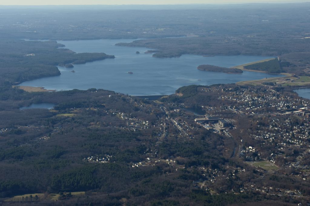
The Wachusett Reservoir is the second largest body of water in the state of Massachusetts. It is located in central Massachusetts, northeast of Worcester. It is part of the water supply system for metropolitan Boston maintained by the Massachusetts Water Resources Authority (MWRA). It has an aggregate capacity of 65 billion US gallons (250,000,000 m3) and an area of almost 7 square miles (18 km2). Water from the reservoir flows to the covered Norumbega Storage Facility via the Cosgrove Tunnel and the MetroWest Water Supply Tunnel. The reservoir has a maximum depth of 120 feet (37 m) and a mean depth of 48 feet (15 m). The reservoir serves as both an intermediate storage reservoir for water from the Quabbin Reservoir, and a water source itself, fed by its own watershed. The reservoir is fed by the Quinapoxet and Stillwater rivers, along with the Quabbin Aqueduct, which carries water from the Quabbin Reservoir. It is part of the Nashua River watershed, forming the headwaters of the river. Because it is an intermediate storage reservoir, its water levels are kept relatively constant while the Quabbin Reservoir fluctuates based on precipitation and demand. At times when the Wachusett Reservoir becomes high due to its own watershed producing a large amount of runoff such as during snow melting, the flow from the Quabbin is shut off and water from the Ware River flows backwards down the Quabbin Aqueduct into the Quabbin Reservoir for storage.
We use GPS information embedded into the photo when it is available.
3D mountains overlay
Adjust mountain panorama to perfectly match your photos because recorded by camera photo position might be imprecise.
Move tool
Rotate tool
Zoom
More customization
Choose which peak labels should make into the final photo and what photo title should be.
Next
Photo Location
Satellitte
Flat map
Relief map
Latitude
Longitude
Altitude
OR
Latitude
°'''
Longitude
°'''
Apply
Register Peak
Peak Name
Latitude
Longitude
Altitude
Register
Teleport
PeakVisor
This 3D model of Sagarmatha National Park in Nepal was made using the PeakVisor app topographic data. The mobile app features higher precision models worldwide, more topographic details, and works offline. Download PeakVisor maps today.
Download OBJ model
PeakVisor
The download should start shortly. If you find it useful please consider supporting the PeakVisor app.
PeakVisor for iOS and Android
Be a superhero of outdoor navigation with state-of-the-art 3D maps and mountain identification in the palm of your hand!