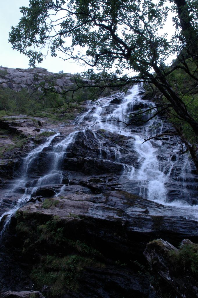
Glen Nevis (Scottish Gaelic: Gleann Nibheis) is a glen in Lochaber, Highland, Scotland, with Fort William at its foot. It is bordered to the south by the Mamore range, and to the north by the highest mountains in the British Isles: Ben Nevis, Càrn Mor Dearg, Aonach Mòr, and Aonach Beag. It is home to one of the three highest waterfalls in Scotland, Steall Falls, where the Allt Coire a'Mhail joins the Water of Nevis in the glen. Below the waterfall is a steeply walled and impressive gorge. The scenic beauty of the glen has led to its inclusion in the Ben Nevis and Glen Coe National Scenic Area, one of 40 such areas in Scotland. A public road runs for 10 km up the Glen, becoming single track after 7 km. There is a hotel, Scottish Youth Hostels Association hostel, and campsite at the bottom of the glen, near Fort William, and a small hamlet further up at Achriabhach. From the car park at the end of the Glen Nevis road, a path continues through a gorge. After a scramble up this rocky path, the view opens up and the path leads into the peaceful upper glen. A wire bridge crosses to the base of the waterfall. Rebuilt by the famous engineer Tom Russell while a member of the Junior Royal Engineers (Dover) JLRRE 82 Fld Sqn MacPhee troop. This bridge was closed for three months in 2010 when one of the cables snapped. The path has been improved periodically to ease access and to reduce the damaging effects of soil erosion caused by many walkers, but it remains challenging in places and, as the sign at the car park warns, potentially fatal. There have been several accidents in Glen Nevis, including the death of a young walker in August 2006. Several films have been shot in Glen Nevis, including some scenes from the Harry Potter movies, Highlander, Highlander III: The Sorcerer, Braveheart and Rob Roy.
We use GPS information embedded into the photo when it is available.
3D mountains overlay
Adjust mountain panorama to perfectly match your photos because recorded by camera photo position might be imprecise.
Move tool
Rotate tool
Zoom
More customization
Choose which peak labels should make into the final photo and what photo title should be.
Next
Photo Location
Satellitte
Flat map
Relief map
Latitude
Longitude
Altitude
OR
Latitude
°'''
Longitude
°'''
Apply
Register Peak
Peak Name
Latitude
Longitude
Altitude
Register
Teleport
PeakVisor
This 3D model of Sagarmatha National Park in Nepal was made using the PeakVisor app topographic data. The mobile app features higher precision models worldwide, more topographic details, and works offline. Download PeakVisor maps today.
Download OBJ model
PeakVisor
The download should start shortly. If you find it useful please consider supporting the PeakVisor app.
PeakVisor for iOS and Android
Be a superhero of outdoor navigation with state-of-the-art 3D maps and mountain identification in the palm of your hand!


.jpg)


