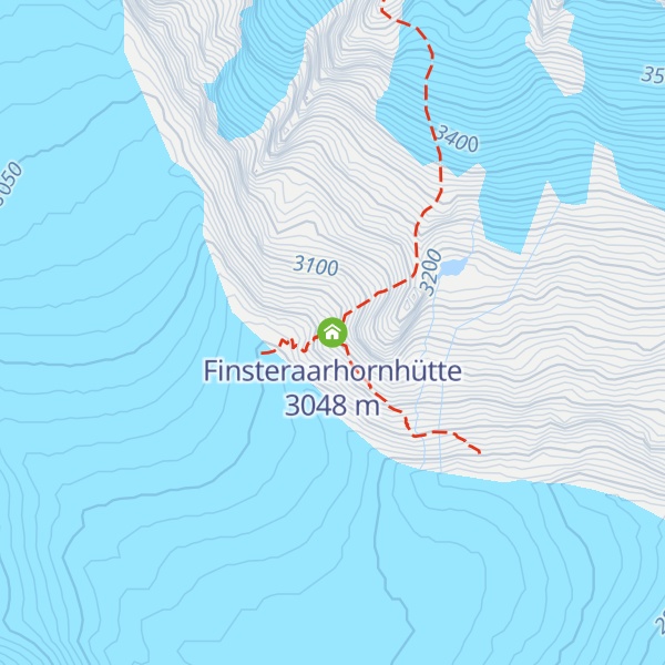
The Finsteraarhorn Hut (German: Finsteraarhornhütte) is a mountain hut of the Swiss Alpine Club, located north of Fieschertal in the canton of Valais. It lies at a height of 3,048 metres (10,000 ft) above sea level at the southern foot of the Finsteraarhorn, the highest peak of the Bernese Alps. The hut overlooks the upper basin of the Fiescher Glacier, which is among the largest of the range. It is located a few kilometres east of the Grünhornlücke. The hut is set in a very remote area and is accessible only to mountaineers as all accesses involve glacier crossing. The shortest access is from the Jungfraujoch train station (6 hours). The Finsteraarhorn Hut is the base of the normal route to the summit of Finsteraarhorn, it is also used to climb other high summits in the area (Gross Fiescherhorn, Grünhorn).
We use GPS information embedded into the photo when it is available.
3D mountains overlay
Adjust mountain panorama to perfectly match your photos because recorded by camera photo position might be imprecise.
Move tool
Rotate tool
Zoom
More customization
Choose which peak labels should make into the final photo and what photo title should be.
Next
Photo Location
Satellitte
Flat map
Relief map
Latitude
Longitude
Altitude
OR
Latitude
°'''
Longitude
°'''
Apply
Register Peak
Peak Name
Latitude
Longitude
Altitude
Register
Teleport
PeakVisor
This 3D model of Sagarmatha National Park in Nepal was made using the PeakVisor app topographic data. The mobile app features higher precision models worldwide, more topographic details, and works offline. Download PeakVisor maps today.
Download OBJ model
PeakVisor
The download should start shortly. If you find it useful please consider supporting the PeakVisor app.
PeakVisor for iOS and Android
Be a superhero of outdoor navigation with state-of-the-art 3D maps and mountain identification in the palm of your hand!