The Verdugo Mountains, also known as the Verdugo Hills or simply The Verdugos, are a small, rugged mountain range of the Transverse Ranges system in Los Angeles County, California. Located just south of the western San Gabriel Mountains, the Verdugo Mountains region incorporates the cities of Burbank, Glendale, Pasadena, and La Cañada Flintridge; the unincorporated communities of Altadena and La Crescenta-Montrose; as well as the City of Los Angeles neighborhood of Sunland-Tujunga.
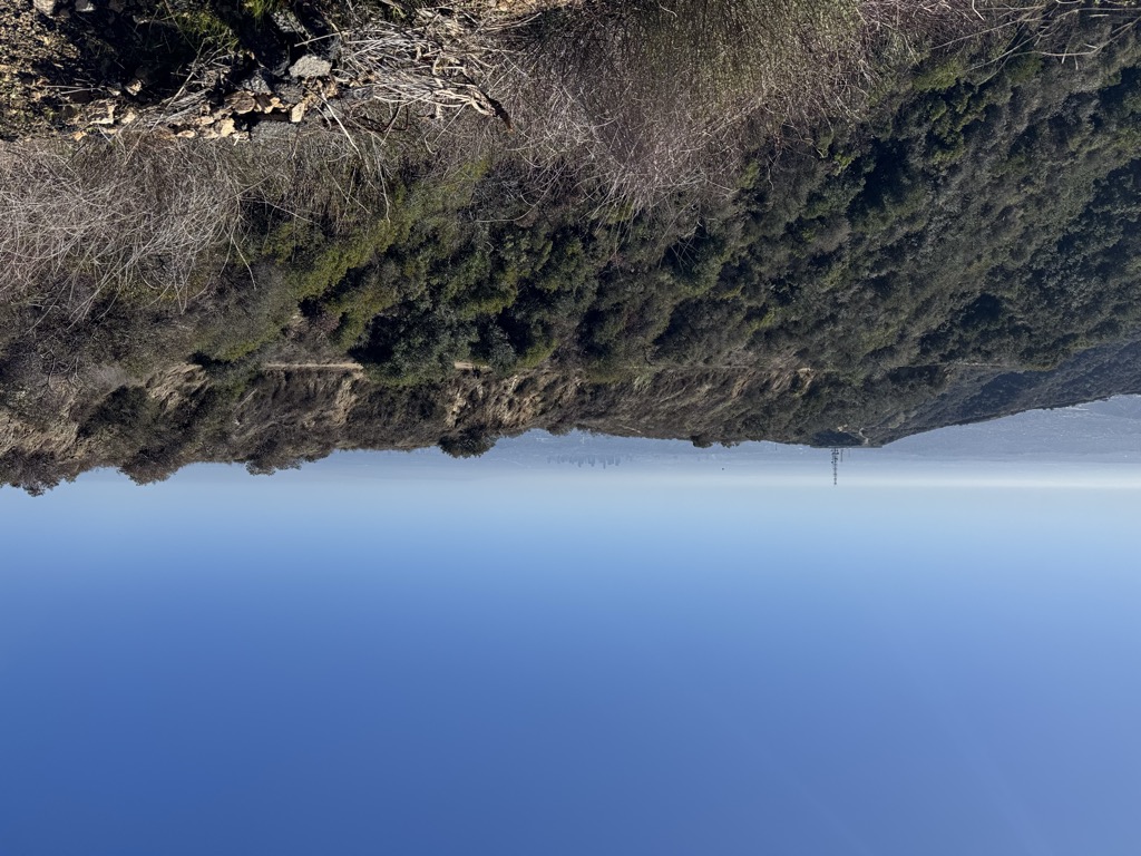
Surrounded entirely by urban development, the Verdugo Mountains represent an isolated wildlife island and are in large part under public ownership in the form of undeveloped parkland. The mountains are used primarily for recreation in the form of hiking and mountain biking, and as the site of communications installations on the highest peaks.
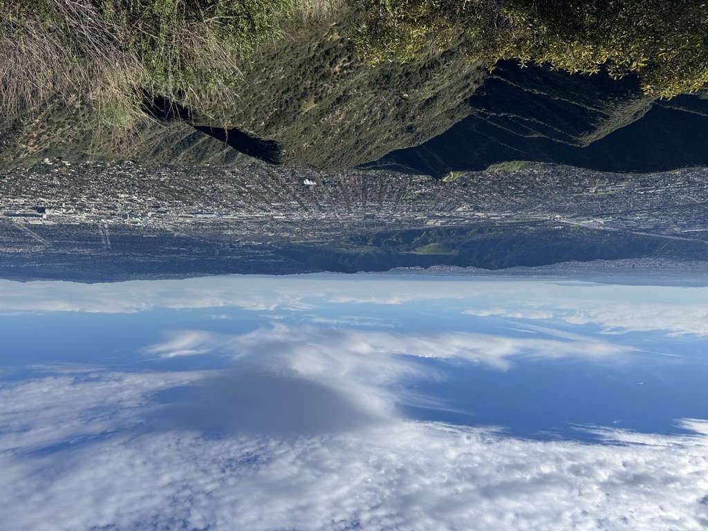
The mountains arise directly from the eastern floor of the San Fernando Valley, exaggerating their height from some vantages. Beginning with foothills, they rapidly rise to rugged sections, with the highest peaks topping 3,000'.
The northwest-trending range is approximately 8 miles (13 km) long by 3.25 miles (5.23 km) wide, and roughly parallels the southern front of the San Gabriel Mountains at a distance of 1 mile (1.6 km) to 2 miles (3.2 km), with the Crescenta Valley lying between the two. The southern front of the range forms part of the northeastern boundary of the San Fernando Valley; at their southeastern end the Verdugo Mountains are separated from the San Rafael Hills by the Verdugo Wash.
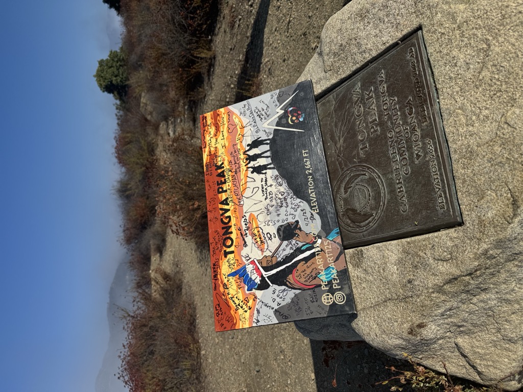
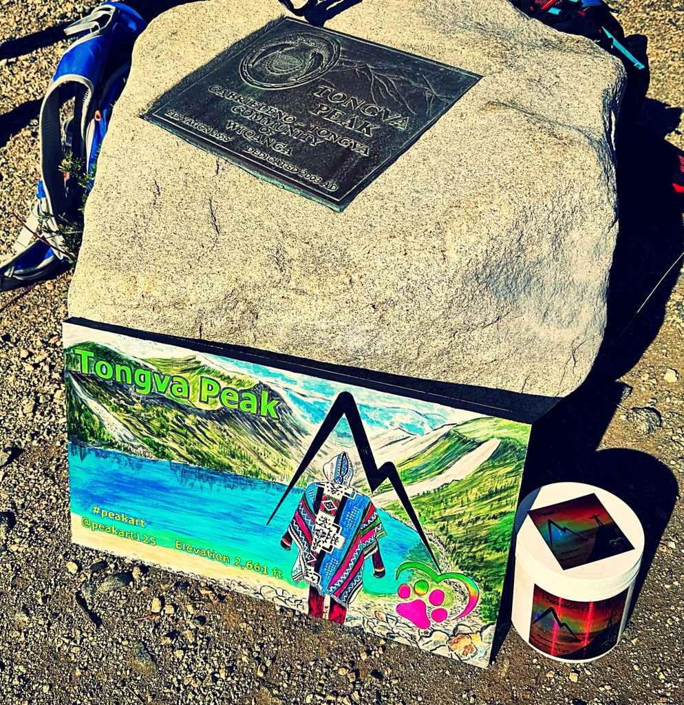
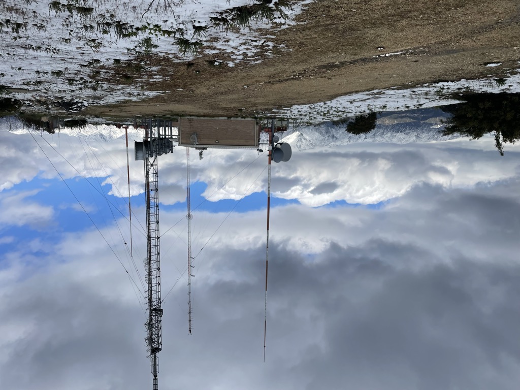
The highest summit is the informally named Verdugo Peak (3,126 feet (953 m)), located near the center of the range and rising to approximately 2,200 feet (670 m) above its southern base. Other peaks include Tongva Peak (2,656 feet), recently named in honor of the Tongva (Gabrielino) people, the original inhabitants of much of the Los Angeles Basin, Santa Monica Mountains, and San Gabriel Valley areas. Other informally named peaks are Mount La Tuna on the north end and Mount Thom on the south end of the range. With the exception of Mount La Tuna, all these summits, as well as several others, are occupied by communications towers.
The Verdugo Mountains lie within the corporate boundaries of the cities of Glendale, Burbank, and Los Angeles. The neighborhood of La Crescenta, most of which lies within Glendale, is adjacent to the range's northern end, as are the Los Angeles neighborhoods of Tujunga, Sunland, Shadow Hills, and Sun Valley (the last of which includes La Tuna Canyon).
The Verdugo Mountains consist of an east-west-trending antiformal fault block, bounded on the south by the Verdugo Fault, a north-dipping reverse fault, and on the north by the Sierra Madre thrust fault near the front of the San Gabriel Mountains, thus including the sediment-covered Crescenta Valley within the Verdugo Mountains Block. The Verdugo Fault lies slightly south of the topographic range front and is completely covered by sediments.
The rocks within the Verdugo Mountains block are almost entirely igneous and metamorphic similar to the crystalline basement rocks exposed to the north in that portion of the San Gabriel Mountains south of the San Gabriel Fault. These consist of gneiss, and gneissic diorite and quartz diorite, intruded by irregular bodies of equigranular granitic rocks, predominantly quartz diorite and granodiorite, with accompanying pegmatite and aplite. Exposed rocks in the Shadow Hills neighborhood at the extreme northwestern end of the Verdugos are typically marine sedimentary rocks of Miocene age, predominantly sandstone and shale.
The Verdugo Mountains are part of the western Transverse Ranges, which have risen in the last 7 million years as the result of contractional deformation resulting from transpressional motion and rotation of crustal blocks in the "Big Bend" region of the San Andreas Fault. The amount of crustal shortening since the beginning of the Pliocene has been estimated to be on the order of 7 kilometers (4.3 mi). The Verdugo fault and Sierra Madre thrust are part of a complex system of faults that accommodate some of this shortening and generally become younger to the south, with the Verdugo Fault possibly being the youngest member of this system and forming the current boundary between this portion of the western Transverse Ranges and the Los Angeles basin. Uplift along the Verdugo fault may total approximately 2.5 km (1.6 mi), at a minimum rate of 1.1 km (0.68 mi) per million years since 2.3 million years ago, moving the crystalline rocks of the Verdugo Mountains up and over younger Tertiary and Quaternary sediments to the south. The Verdugo Mountains are, therefore, young and rapidly rising, reflected in their steep topography and rapid rates of erosion.
Glendale
Pasadena
La Cañada Flintridge
Burbank
Altadena
La Crescenta-Montrose
Sunland-Tujunga
The Verdugo Mountains lie almost entirely within the chaparral plant community, as defined by Munz and later authors, including Sawyer et al. This dense, shrub-dominated community of the California chaparral and woodlands is more highly developed on the north-facing slopes than on the drier, hotter south-facing slopes. Among the shrub species that characterize this community, prominent in the Verdugos are laurel sumac (Malosma laurina), toyon (Heteromeles arbutifolia), poison oak (Toxicodendron diversilobum), chamise (Adenostoma fasciculatum) and two species of California-lilac (Ceanothus crassifolius and Ceanothus oliganthus). Native trees are restricted to protected canyons, especially on the shadier north slope of the range, where soil moisture levels are higher. Coast live oak (Quercus agrifolia), California bay laurel (Umbellularia californica), California sycamore (Platanus racemosa), California walnut (Juglans californica), and several species of willow (Salix spp.) are the most common native trees. Non-native trees, particularly pines (Pinus spp.), cypress (Cupressus spp.), locust (Robinia pseudoacacia), and Australian eucalyptus (Eucalyptus spp.) have been planted locally along the fire roads and, most notably, in the Fire Warden's Grove, established in the wake of a wildfire in 1927.
Except for a tenuous link to the large wild area in the San Gabriel Mountains through Big Tujunga Wash at their northwestern end, the Verdugo Mountains are an urban wildlife island completely surrounded by development. Among the large mammals, coyote (Canis latrans) and mule deer (Odocoileus hemionus) are the most common; mountain lions (Puma concolor) and black bears (Ursus americanus) have occasionally been reported. The many rodent species support a population of western rattlesnakes (Crotalus viridis). Of the numerous bird species present, the most characteristic of the chaparral here, and throughout California, is the small, seldom seen but often heard wrentit (Chamaea fasciata). With its call of three or four chirps followed by an accelerating trill, often likened to the sound of a dropped ping-pong ball, the wrentit provides the most characteristic sound of the chaparral.
The Verdugo Mountains have warm, dry summers and cool wet winters. Snow infrequently falls along the crest during the coldest winter storms, but melts rapidly. Annual average precipitation increases with elevation (due to the orographic lift effect), from 17-21 inches at the base to about 24–28 inches at the crest. Annual rainfall totals are highly variable from year to year, with the higher totals usually in El Nino years. Most of the rain falls between November and March during periodic frontal passages.
The mountains were part of the indigenous Tongva people's homelands for over 7,000 years, with villages at some springs in the canyons. The village of Wikangna was located in the area, possibly located at what is now the Verdugo Hills Golf Course.
The Verdugo Mountains were named for Jose Maria Verdugo, holder of the Rancho San Rafael land grant, which covered the mountains during California's Spanish and Mexican periods. On October 20, 1784 Pedro Fages, the military governor of Alta California, granted Jose Maria Verdugo permission to use the rancho, known officially by the name San Rafael but informally called "La Zanja" by Verdugo. The rancho's boundaries were primarily defined by the Verdugo Mountains, the Arroyo Seco and the Los Angeles River, with the boundary following north along the east bank of the river and wrapping westerly around Griffith Park to a point near the Travel Town Museum in the park.
One of the earliest attempts to access and develop the interior of the Verdugo Mountains was the 1912 proposal by Colonel Lewis Ginger to build a cable incline railroad to the summit of Mount Verdugo, now known as Mount Thom. The proposed Glendale & Verdugo Mountain Railway was to run in a straight line from the Pacific Electric's Casa Verdugo station at the top of Brand Boulevard to the summit of Mount Verdugo, employing cars with stepped seating similar to those of Angels Flight on Bunker Hill in Los Angeles. Initially, Colonel Ginger had proposed that his cable railway would lift a Pacific Electric car directly to the summit, but Henry E. Huntington did not approve of this scheme. The railway was to have four or five stations along the incline and a large visitor's center at the summit. Several months after the initial proposal, the route was altered to run up the west side of Verdugo Canyon from a hoped-for extension of the Pacific Electric up Verdugo Canyon to Montrose. Interest in the cable railway continued for about a year, but the project was abandoned before a company could be formed, largely as the result of the Pacific Electric's decision not to build the Montrose extension.
Fire is a natural component of the chaparral ecosystem, and the plants that comprise it are largely adapted to survive fire or to reproduce after it. More specifically, the members of this plant community are adapted to a particular fire regime, which is characterized by intensity and seasonality, but most importantly, by the frequency of fires. In the southern California chaparral, natural frequencies of 30 to 40 years are typical, with some areas going as long as 100 years without fires and others burning more frequently. It has been estimated the chaparral plant community can persist over the long term only with a fire frequency at a given site of no shorter than several decades, or perhaps longer, although there is variability in the tolerance of different species. Repeated shorter intervals between fires promote so-called "type conversion", in which the shrubby species are replaced by grasses, particularly non-native grasses, and other weedy species.
The Verdugo Mountains have been subject to repeated wildfires in historical times. Major occurrences in the twentieth century include the December, 1927 Burbank Canyon Fire, which started in Haines Canyon in the San Gabriel Mountains and burned south into the range, consuming approximately 100 homes in Burbank's Sunset Canyon.
The La Tuna Canyon Fire of November, 1955 burned over almost the entire western portion of the range, ultimately destroying approximately 4,500 acres (1,800 ha).
The Whiting Woods Fire of March, 1964, started by a power line downed by high winds, burned from the northern edge of the range southward over to crest to consume homes in Glendale.
A fire in November, 1980, also called the La Tuna Canyon Fire, burned 10,000 acres (4,000 ha) in the northern and western portions of the range.
Since 2000, three major fires have occurred in the Verdugo Mountains. In September, 2002, the Mountain Fire burned over two days approximately 750 acres (300 ha) above Glendale, largely on the southern side of the range.
The Harvard Fire started on September 29, 2005, and consumed 1,024 acres (414 ha) both north and south sides of the range north of Burbank during a six-day period.
In September, 2017, the La Tuna fire started north of the Verdugos, jumping Interstate 210 forcing the closure of it, burning both the north and south face of the ranges. The fire ultimately destroyed four homes and 7,003 acres (2,834 ha) of land.
Beginning in 1921, the Los Angeles County Fire Department began a county-wide program of building fire breaks (or more properly, fuel breaks) to slow the spread of fire, and by 1923 the initial breaks had been constructed in the Verdugos. In 1934, the City of Glendale built a 60-foot lookout tower on Verdugo Peak, which was staffed with an observer until it closed in the mid-1950s. In order to conduct the work necessary to build fire breaks and roads, temporary construction camps were located throughout the fire-prone areas of the county. In the Verdugo Mountains, Construction Camp #2 was located in the lower reaches of Deer Canyon, at the end of present-day Beaudry Blvd, for a period during the late 1930s and early 1940s. It is difficult to determine from published sources the dates of construction for the fire roads so important to present-day recreational use of the mountains. The report of the 1955 La Tuna Canyon fire, however, indicates that at least some of these roads were in place by that date.
Verdugo Mountains State Park, California Department of Parks and Recreation
Verdugo Mountains Open Space Preserve, jointly operated by the Santa Monica Mountains Conservancy and the City of Glendale
Brand Park, Glendale
Stough Canyon Nature Center, Burbank
Wildwood Canyon Park, Burbank
La Tuna Canyon Park, Los Angeles
Tujunga Ponds, Los Angeles
The Verdugo Mountains are being considered as part of the proposed Rim of the Valley Corridor National Park.
Other than the Foothill Freeway (I-210) and the nearly parallel La Tuna Canyon Road, both of which traverse only the northwestern tip of the range, the Verdugo Mountains are crossed by no paved roads. By contrast, the range contains more than 25 miles (40 km) of graded and well maintained fire roads that are used extensively by hikers and mountain bike riders. Several abandoned and overgrown fire roads and ridge-top fire breaks are used recreationally as well. Trails, in the sense of engineered and maintained footpaths, are few, the most notable being the 2.2 mile (3.5 km)-long La Tuna Canyon Trail, which was constructed in 1989 by the Los Angeles Conservation Corps with funds provided by the Santa Monica Mountains Conservancy.
La Tuna Fire
Tectonics of the San Gabriel Basin and surroundings, southern California. Robert S. Yeats. Corvallis, Oregon: Oregon State University, Department of Geosciences, 2004.
Los Angeles River: Its Life, Death, and Possible Rebirth. Blake Gumprecht. Baltimore & London: The Johns Hopkins University Press, 1999. ISBN 0-8018-6642-1.
Afoot & Afield in Los Angeles County, 2nd edition, Area B-5. Jerry Schad. Berkeley, California: Wilderness Press, 2000. ISBN 0-89997-267-5.
Tectonics of the San Gabriel Basin and surroundings, southern California. Robert S. Yeats. Corvallis, Oregon: Oregon State University, Department of Geosciences, 2004.
Paleoseismology, active tectonics, and seismic hazards of the Verdugo fault zone, Los Angeles County, California. James F. Dolan. The University, 1997.
Segmentation, slip rates and earthquake dimensions in the active fold-thrust belt of northern Los Angeles Basin, California. Robert S. Yeats. Dept. of Geosciences, Oregon State University, 1996.
Geology of Earthquakes. Robert S. Yeats, Kerry E. Sieh, and Clarence R. Allen. Oxford University Press, 1997. ISBN 0-19-507827-6.
Living with Earthquakes in California: A Survivor's Guide. Robert S. Yeats. Oregon State University Press, 2001. ISBN 0-87071-493-7.
The geology of a portion of the western Verdugo mountains. Robert L. Johnston, 1938.
Geology Underfoot in Southern California. Robert Sharp and Allen Glazner. Mountain Press, 1993. ISBN 0-87842-289-7 (2nd Edition released in 2020).
Assembling California. John McPhee. Farrar, Straus and Giroux, 1993. ISBN 0-374-10645-2.
Cycles of Rock and Water: At the Pacific Edge. Kenneth A. Brown. HarperCollins, 1993. ISBN 0-06-016056-X.
Birds of Los Angeles: Including Santa Barbara, Ventura and Orange Counties. Chris C. Fisher and Herbert Clarke. Lone Pine Publications, 1997. ISBN 1-55105-104-4.
A Flora of Southern California. Philip A. Munz. University of California Press, 1974.
Native Trees of Southern California. Victor P. Peterson. University of California Press, 1970.
Illustrated Guide to the Oaks of the Southern Californian Floristic Province: The Oaks of Coastal Southern California and Northwestern Baja California. Fred M. Roberts Jr. F. M. Roberts Publishing, 1995. ISBN 0-9643847-0-1.
Plant Life in the World's Mediterranean Climates: California, Chile, South Africa, Australia and the Mediterranean Basin. Peter R. Dallman. University of California, 1998. ISBN 0-520-20808-0.
Island Called California: An Ecological Introduction to Its Natural Communities. Elna Bakker. Second Edition. University of California Press, 1984. ISBN 0-520-04947-0.
Natural History of Vacant Lots (California Natural History Guides). Matthew F. Vessel and Herbert H. Wong. University of California Press, 1987. ISBN 0-520-05250-1.
Growing California Native Plants. Marjorie D. Schmidt. University of California Press, 1981. ISBN 0-520-03762-6.
Introduction to California Beetles. Arthur V. Evans and James N. Hogue. University of California Press, 2004. ISBN 0-520-24035-9.
Geography and evolution in the pocket gophers of California. Joseph Grinnell. USGPO, 1927.
Evolutionary Dynamics of the Pocket Gopher Thomomys Bottae, With Emphasis on California Populations. James L. Patton and Margaret F. Smith. University of California Press, 1990. ISBN 0-520-09761-0.
The Verdugos of Hispanic California. Marie E. Northrop. 1978.
Angeles Front Country Trail Map. San Rafael, California: Tom Harrison Maps, 2001. ISBN 1-877689-65-3.
Verdugo Mountains trail map. Matt Maxon, 2005 http://pctmap.homeip.net/data/PDF/Verdugo%20Mtns%2001-16-05.pdf
Burbank, California, 7.5 minute topographic quadrangle map. United States Geological Survey.
Pasadena, California, 7.5 minute topographic quadrangle map. United States Geological Survey.
Mount La Tuna - 34.22327°N 118.33763°W / 34.22327; -118.33763
Mount Thom - 34.18717°N 118.25596°W / 34.18717; -118.25596
Outdoor LA Hiking Trails - Hiking trails in the area with maps and directions to the trailheads.
Verdugo Mountains Park Property - California State Parks page for the Verdugo Mountains Park Property
Rim of the Valley Corridor Special Resource Study - National Park Service page about the Rim of the Valley Corridor
LA Trails - Verdugo Mountains - a listing of most of the hiking trails in the Verdugo Mountains.
Verdugo Hills Community Hike - an annual community hike and trail run in the Verdugos involving the Glendale, Burkbank, and Crescenta Valley communities
Parks in the Verdugo & San Rafael Mountains Region - Santa Monica Mountains Conservancy page, with an interagency list of parks and other protected areas in the Verdugo Mountains/San Rafael Hills area
There's a trail called Verdugo Motorway leading to the summit.
We use GPS information embedded into the photo when it is available.
3D mountains overlay
Adjust mountain panorama to perfectly match your photos because recorded by camera photo position might be imprecise.
Move tool
Rotate tool
Zoom
More customization
Choose which peak labels should make into the final photo and what photo title should be.
Next
Photo Location
Satellitte
Flat map
Relief map
Latitude
Longitude
Altitude
OR
Latitude
°'''
Longitude
°'''
Apply
Register Peak
Peak Name
Latitude
Longitude
Altitude
Register
Teleport
PeakVisor
This 3D model of Sagarmatha National Park in Nepal was made using the PeakVisor app topographic data. The mobile app features higher precision models worldwide, more topographic details, and works offline. Download PeakVisor maps today.
Download OBJ model
PeakVisor
The download should start shortly. If you find it useful please consider supporting the PeakVisor app.
PeakVisor for iOS and Android
Be a superhero of outdoor navigation with state-of-the-art 3D maps and mountain identification in the palm of your hand!