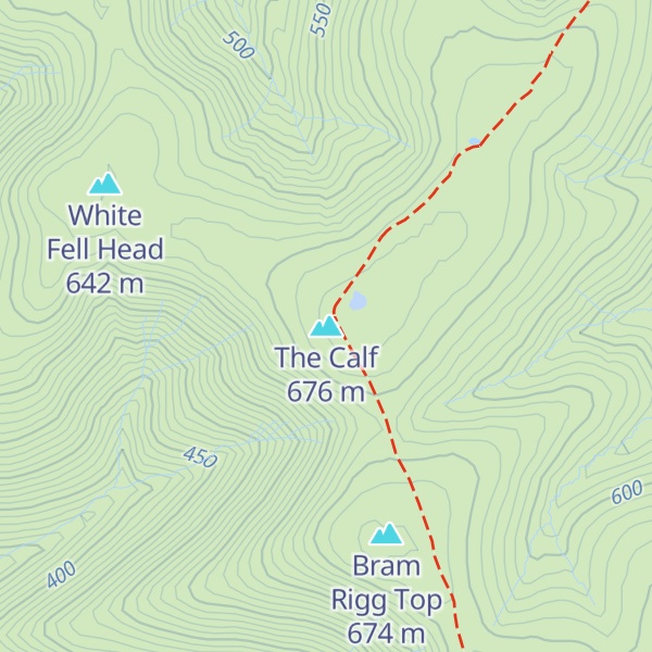
The Calf, at an elevation of 676 metres (2,218 ft), is the highest point in the Howgill Fells, an area of high ground in north-west England. It is in the north-west of the Yorkshire Dales in Westmorland and Furness in the county of Cumbria (historically it was on the West Riding of Yorkshire/Westmorland boundary). It can be ascended from the town of Sedbergh to the south, by way of Cautley Spout from the east, or up the long valley of Langdale from the north. The Sedbergh ascent is the most popular, and has the distinction of being on good paths all the way.
The summit commands an extensive panorama, although foreground detail is obscured by the extreme flatness of the plateau. A twenty-mile skyline of the Lakeland peaks can be seen, as well as the Yorkshire Three Peaks and many of the nearer Howgill Fells.
Alfred Wainwright, in his Walks on the Howgill Fells, describes a route from Sedbergh to Calders and The Calf as "the classic high-level walk on the Howgill Fells". He includes a drawing of the trig point on the summit of The Calf, discusses a "reclining" standing stone 400 yards to the north-east which appears on large-scale Ordnance Survey maps, and spends a column of text discussing "the altitude of Calders", which he estimates as 2215 ft. He gives diagrams of the views covering the full 360 degrees, and sketches of the Lakeland skyline and the view of the Yorkshire Three Peaks to the south-east. He also describes ascents of the Calf from Castley ("this impressive expedition", "a beautiful walk"), Beck Houses farm on the west of the Howgills (" this high-level traverse of the plateau splendidly reveals the topographical details of the Howgills") and Bowderdale ("the longest direct ascent of The Calf").
Calders, at 674 metres (2,211 ft), is about 1 km SSE of the summit of The Calf. It is classified as a Hewitt.
There's a trail leading to the summit.
By elevation The Calf is
# 20 out of 786 in Yorkshire Dales National Park
By prominence The Calf is
# 19 out of 12948 in the England Hills # 3 out of 786 in Yorkshire Dales National Park # 19 out of 13057 in England # 11 out of 1704 in Cumbria
We use GPS information embedded into the photo when it is available.
3D mountains overlay
Adjust mountain panorama to perfectly match your photos because recorded by camera photo position might be imprecise.
Move tool
Rotate tool
Zoom
More customization
Choose which peak labels should make into the final photo and what photo title should be.
Next
Photo Location
Satellitte
Flat map
Relief map
Latitude
Longitude
Altitude
OR
Latitude
°'''
Longitude
°'''
Apply
Register Peak
Peak Name
Latitude
Longitude
Altitude
Register
Teleport
PeakVisor
This 3D model of Sagarmatha National Park in Nepal was made using the PeakVisor app topographic data. The mobile app features higher precision models worldwide, more topographic details, and works offline. Download PeakVisor maps today.
Download OBJ model
PeakVisor
The download should start shortly. If you find it useful please consider supporting the PeakVisor app.
PeakVisor for iOS and Android
Be a superhero of outdoor navigation with state-of-the-art 3D maps and mountain identification in the palm of your hand!