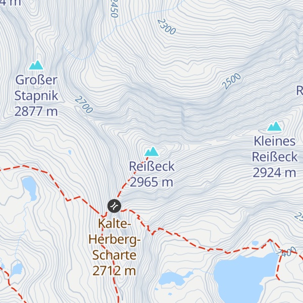
The Reißeck, also Großes Reißeck ("Great Reisseck") is, at 2,965 metres above the Adriatic (9,728 ft), the highest peak of the Reißeck Group in the High Tauern of Carinthia, Austria. The range forms the southern part of the larger Ankogel Group with its highest summit, the Hochalmspitze, separated by the col of Mallnitzer Scharte at 2,673 m (8,770 ft). The mountain also gives its name to the Reißeck municipality, located to the south in the Möll valley.
The name Reißeck is derived from an old waterbody name, something like Reisach = "mountain stream" or "torrent", which became the Middle High German rîs = "the falling one".
West and south of the summit block lie the reservoirs of the Verbund Reißeck-Kreuzeck hydropower group, connected with the neighbouring Kölnbrein Dam in the Malta Valley. The Reisseck Railway (Reißeckbahn) funicular and the narrow-gauge Reisseck Mountain Railway, built in the 1950s for the construction of the power station, later ran passenger services and was used for the access of tourists from the Möll valley up to the Alpine huts. Operations on both lines ceased in 2014/2016 and were not resumed so far. The Reißeck Hut, built in 1908 and managed by the ÖGV section of the Austrian Alpine Club, is located at 2,287 m (7,503 ft) in the immediate vicinity of the former Schoberboden top station, right below the dam of the Großer Mühldorfer See reservoir. A nearby hotel and the adjacent small ski area, opened in the 1960s, today are closed.
The normal route runs via the Kalte Herberg col and south arête, an easy climb, to the summit, but it does require sure-footedness. Starting points are the Reißeck Hut or the unmanaged Neue Moos Hut. East-northeast of the Großes Reißeck lies the Kleines Reißeck peak ("Little Reisseck", 2,924 m); the ridge crossing runs along steep grassy slopes, but is otherwise technically easy. The Reißeck summit offers panoramic views to the surrounding High Tauern ranges, as well as to the Dolomites, Karawanks and Julian Alps in the south.
There's an alpine trail (T4) leading to the summit. Reißeck is one of the 1 peaks along the Wanderweg 562.
The nearest mountain hut is Mooshütte located 1 894m/6 214ft W of the summit.
By elevation Reißeck is
# 32 out of 450 in the Ankogel Group
By prominence Reißeck is
# 8 out of 450 in the Ankogel Group # 41 out of 1052 in Spittal an der Drau # 52 out of 1786 in the Hohe Tauern
We use GPS information embedded into the photo when it is available.
3D mountains overlay
Adjust mountain panorama to perfectly match your photos because recorded by camera photo position might be imprecise.
Move tool
Rotate tool
Zoom
More customization
Choose which peak labels should make into the final photo and what photo title should be.
Next
Photo Location
Satellitte
Flat map
Relief map
Latitude
Longitude
Altitude
OR
Latitude
°'''
Longitude
°'''
Apply
Register Peak
Peak Name
Latitude
Longitude
Altitude
Register
Teleport
PeakVisor
This 3D model of Sagarmatha National Park in Nepal was made using the PeakVisor app topographic data. The mobile app features higher precision models worldwide, more topographic details, and works offline. Download PeakVisor maps today.
Download OBJ model
PeakVisor
The download should start shortly. If you find it useful please consider supporting the PeakVisor app.
PeakVisor for iOS and Android
Be a superhero of outdoor navigation with state-of-the-art 3D maps and mountain identification in the palm of your hand!