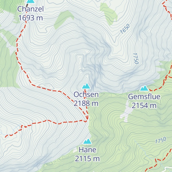
The Ochsen (or Ochse) is a 2,188.4 metres high mountain in the Bernese Alps, overlooking Schwefelbergbad in the canton of Bern. It is the highest mountain of the Gantrisch chain. The Louigrat is the easiest path (T3, slightly exposed at the top: very steep rocky passages), taking approximately 3 hours. Another path goes via the north ridge via Chli Ochsen (T4, steep, rocky and slippery). There is a memorial just below the small summit area.
There's a hiking trail (T2) leading to the summit.
The nearest mountain hut is Mittliste Morgete located 1 653m/5 423ft ESE of the summit.
By elevation Ochsen is
# 1 out of 201 in Verwaltungskreis Bern-Mittelland # 3 out of 94 in Gantrisch Nature Park
By prominence Ochsen is
# 53 out of 1882 in the Swiss Prealps # 2 out of 201 in Verwaltungskreis Bern-Mittelland # 11 out of 279 in Verwaltungskreis Frutigen-Niedersimmental # 41 out of 1615 in Bern # 2 out of 94 in Gantrisch Nature Park
We use GPS information embedded into the photo when it is available.
3D mountains overlay
Adjust mountain panorama to perfectly match your photos because recorded by camera photo position might be imprecise.
Move tool
Rotate tool
Zoom
More customization
Choose which peak labels should make into the final photo and what photo title should be.
Next
Photo Location
Satellitte
Flat map
Relief map
Latitude
Longitude
Altitude
OR
Latitude
°'''
Longitude
°'''
Apply
Register Peak
Peak Name
Latitude
Longitude
Altitude
Register
Teleport
PeakVisor
This 3D model of Sagarmatha National Park in Nepal was made using the PeakVisor app topographic data. The mobile app features higher precision models worldwide, more topographic details, and works offline. Download PeakVisor maps today.
Download OBJ model
PeakVisor
The download should start shortly. If you find it useful please consider supporting the PeakVisor app.
PeakVisor for iOS and Android
Be a superhero of outdoor navigation with state-of-the-art 3D maps and mountain identification in the palm of your hand!