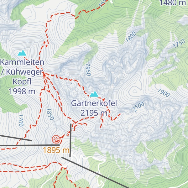
Gartnerkofel (2,195 m) is a mountain of the Carnic Alps in Carinthia, Austria. It is located on the main chain of the Carnics above the Naßfeld Pass, near the border with Italy. The nearest town is Hermagor-Pressegger See. The mountain has two summits, and ravines fall down from its northern slopes, which are separated by rocky ridges. The normal route is from the northwest, from where it an easy climb across the ridge to the summit. The mountain is also a popular ski touring destination.
There's a hiking trail (T2) called Gartnerkofel Normalweg leading to the summit.
The nearest mountain hut is WatschigerAlm located 1 329m/4 362ft WSW of the summit.
By elevation Gartnerkofel is
# 87 out of 302 in Hermagor
By prominence Gartnerkofel is
# 6 out of 302 in Hermagor # 26 out of 2446 in Carinthia # 29 out of 1900 in the Carnic and Gailtal Alps
We use GPS information embedded into the photo when it is available.
3D mountains overlay
Adjust mountain panorama to perfectly match your photos because recorded by camera photo position might be imprecise.
Move tool
Rotate tool
Zoom
More customization
Choose which peak labels should make into the final photo and what photo title should be.
Next
Photo Location
Satellitte
Flat map
Relief map
Latitude
Longitude
Altitude
OR
Latitude
°'''
Longitude
°'''
Apply
Register Peak
Peak Name
Latitude
Longitude
Altitude
Register
Teleport
PeakVisor
This 3D model of Sagarmatha National Park in Nepal was made using the PeakVisor app topographic data. The mobile app features higher precision models worldwide, more topographic details, and works offline. Download PeakVisor maps today.
Download OBJ model
PeakVisor
The download should start shortly. If you find it useful please consider supporting the PeakVisor app.
PeakVisor for iOS and Android
Be a superhero of outdoor navigation with state-of-the-art 3D maps and mountain identification in the palm of your hand!