The East Tintic Mountains are a mountain range in central Juab, Utah, and Tooele counties in Utah, United States on the east margin of the Great Basin just west of the Wasatch Front about 50 miles (80 km) south-southeast of Salt Lake City. The community of Eureka is an old mining town near the center of the range. U.S. Route 6 Passes through the central part of the range and through Eureka.
The Tintic Mining District is located in the central part of the range. The district was an important producer of silver, gold and base metals during the late 19th and early 20th centuries. The mountain range, Tintic Valley, and the mining district are named after Chief Tintic of the Goshute.
The Tintic Smelter Site, the Sunbeam Mine, and the Silver City Cemetery, listed on the National Register of Historic Places, preserve some remnants of the district.
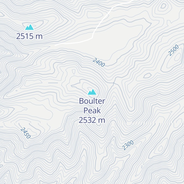
By elevation Boulter Peak is
# 1 out of 48 in the East Tintic Mountains # 19 out of 92 in Juab County # 78 out of 215 in Tooele County
By prominence Boulter Peak is
# 1 out of 48 in the East Tintic Mountains # 63 out of 3409 in Utah # 6 out of 92 in Juab County # 9 out of 215 in Tooele County
We use GPS information embedded into the photo when it is available.
3D mountains overlay
Adjust mountain panorama to perfectly match your photos because recorded by camera photo position might be imprecise.
Move tool
Rotate tool
Zoom
More customization
Choose which peak labels should make into the final photo and what photo title should be.
Next
Photo Location
Satellitte
Flat map
Relief map
Latitude
Longitude
Altitude
OR
Latitude
°'''
Longitude
°'''
Apply
Register Peak
Peak Name
Latitude
Longitude
Altitude
Register
Teleport
PeakVisor
This 3D model of Sagarmatha National Park in Nepal was made using the PeakVisor app topographic data. The mobile app features higher precision models worldwide, more topographic details, and works offline. Download PeakVisor maps today.
Download OBJ model
PeakVisor
The download should start shortly. If you find it useful please consider supporting the PeakVisor app.
PeakVisor for iOS and Android
Be a superhero of outdoor navigation with state-of-the-art 3D maps and mountain identification in the palm of your hand!