
Scan the QR code and open PeakVisor on your phone
Upper Mayun River Special Conservation Area has 6 named peaks. The highest is Chepingliaoshan at 699 m. Other notable peaks include Wuzhishan, Chepingliao Shan and Neishuangxishan.
The Upper Masu River Special Conservation Area is located just south of the Dajianhou Mountain Special Scenic Area of Yangmingshan National Park in northern Taiwan. The highest and most prominent peak in the conservation area is Cheping Liaoshan (車坪寮山), standing at a solid 699 metres (2,293 ft) in elevation. The area contains a total of 6 named mountains.
The Upper Masu River Special Conservation Area (瑪鋉溪上游水源涵養核心特別景觀區) is situated in the Xizhi District (汐止區) of New Taipei City (新北市). It is located to the south of the Dajianhou Mountain Special Scenic Area (磺嘴山大尖後山外圍核心特別景觀區) of Yangmingshan National Park (陽明山國家公園) in the northern part of Taiwan.
The easternmost mountain of Yourui Shan (友蚋山), sometimes called Wutu Shan (烏塗山), which is one of the area’s most prominent peaks, straddles the border with Keelung City (基隆市) . Meanwhile, the area’s fourth and fifth highest peaks, Neishuangxi Shan (內雙溪山) and Xiangdui Shan (香對山) , extend over the area’s western boundary into the Wanli District (萬里區) of New Taipei City.
Interestingly, the conservation area’s Cheping Liaoshan forms the northern peak of Wuzhishan (五指山). Wuzhishan is translated as ‘five finger mountain;’ thus, five peaks emerge from Wuzhishan, with Cheiping Liaoshan being the grandest of the group.
The other five named mountains in the Upper Mayun Special Conservation Area are Whuzishan (五指山) , Cheping Liaolun (車坪寮崙) , Neishuangxi Shan (內雙溪山) , Xiangdui Shan (香對山), and Yourui Shan (友蚋山) .
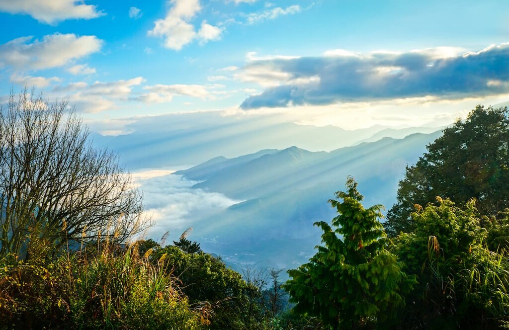
The Masu River (瑪鋉溪) begins its surge in the valleys of Dajian Mountain (大尖山) and Cheping Liaoshan. It flows eastwards for 22.5 km (14 mi) toward Wanli Beach, where it connects with the waters of the Pacific Ocean. During the rainy season, the river becomes turbulent; however, its course is relatively gentle for most of the year.
Yangmingshan National Park (陽明山國家公園) is located right to the north of the Upper Masu River Special Conservation Area. The northern tip of the Northeast Coastal Reserve (東北角沿海保護區) is situated to the east of the region. The Tamsui River (淡水河) runs through Taipei City (台北市) to the west, while the popular hiking trail towards Xinshan (新山) summit lies in the south.
The Upper Masu River Special Conservation Area was once an underwater zone before the island of Taiwan surfaced. The seawaters of the Pacific Ocean once swept over the plates where Taiwan now stands.
Bits of sediment from disintegrating granite were carried from the riverbeds of the South China Sea, forming an accumulation of the seabed of Taiwan. Geologists have traced the sedimentary strata of the Wuzhishan peaks back to about 24 to 30 million years ago.
The rock strata of the Wuzhishan mountains are composed primarily of layers. Orthoquartzite and paraquartzite sandstone mainly comprise the rock strata. In addition, medium-sized gravel-like sandstone, black and grey shale, tiny specs of coal seams and sand rods are found in the upper and lower layers in the hills of Wuzhishan.
A subtropical rainforest and an evergreen temperate broadleaf forest characterise the vegetation of the Upper Masu River Special Conservation Area. The northeast monsoons affect the plant life in this area as the cold dampness nurtures the plant growth commonly found in higher elevations. In addition, the torrents of rain ensure that the ground is well watered to nourish the ecological environment.
An evergreen broadleaf forest of acacia, mountain palm, Taiwan white pine, olive tree, chestnut tree, and the tung tree, also known as Vernicia fordii, forms a viridescent tunnel of foliage from the muddy earthen path to the verdant forest canopy. In addition to this, the mountains are graced with the sightly blooming of wild ginger, hibiscus, white egret flower, and tung blossoms (油桐花).
Swarms of silvergrass (Miscanthus sinensis) dominate the mountain peaks of Wuzhishan, while bamboo forests featuring Pseudosasa japonica are found in the sheltered forest areas below the summit. In addition to bamboo, a forest of pine trees is present, particularly on the mountain pass between Wuzhishan and Meihuashan (梅花山).
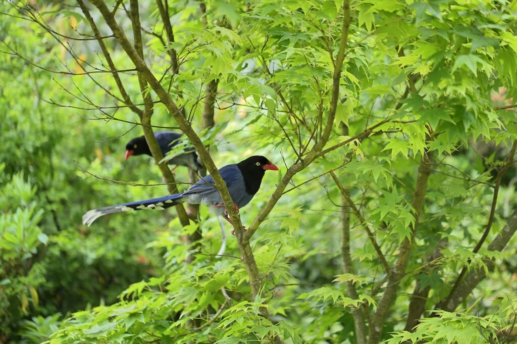
The sheltered forest hills are a haven for butterflies and birds. Female brown shade butterflies are relatively easy to spot on the trails. Furthermore, the trilling tweets of the Taiwan blue magpie, red-billed black bulbul, and five-colour birds are noticeably familiar in the region. In addition, the area houses many frogs due to the proximity of the Masu River, most notably the Taipei tree frog and central Formosan toads.
The elevated zone of the Upper Masu River Special Conservation Area houses ancient roads that were once used as old passageways, connecting the area of Xizhi to the merchant city of Taipei.
Han Chinese settlers migrated to what is now known as Yangmingshan National Park between 1736 to 1795, where they established rice farms and mastered the craft of stone masonry. Relics of sculpted stone are dotted along the ancient mountain roads.
During the Japanese Occupation Era, the Japanese built a ranch and a golf course on Wuzhishan. This area is now home to Wuzhishan Military Cemetery (五指山國軍示範公墓), which opened on the 29 March 1982. A total of 9,417 graves are lined in organized rows in the well-maintained and groomed cemetery. The cemetery is divided into ten sections, following the military ranking of the deceased.
Instead of being a morbid place, the cemetery is quite a popular destination for locals. Due to its scenic position on 226 ha (558 ac) of elevated land, visitors can enjoy impressive vistas of Taipei, with Taipei101 in full view, and overlook Xizhi District and Keelung City, all from the cemetery.

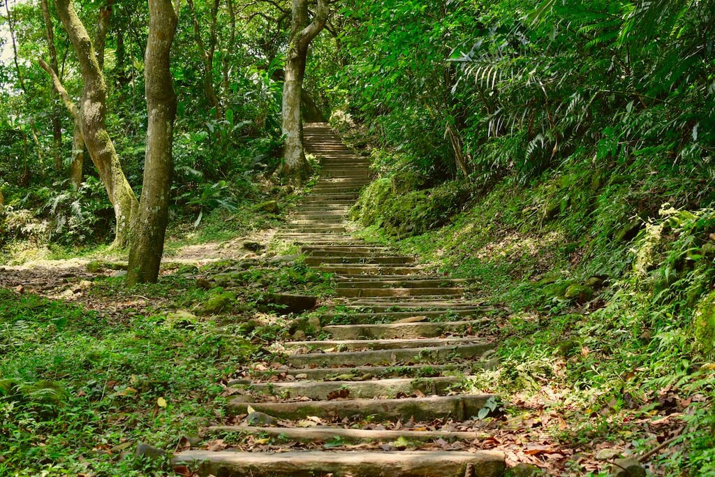
A series of ancient paths and mountain trails are key features of the Upper Masu River Special Conservation Area, together with the expansive vegetation of the Nei Shuangxi Nature Park.
Wuzhishan Historic Trail commences adjacent to the large natural pool of the Beigang River (北港溪). The stoned pathway traces through the forest where elegant ferns sway like soft feathers in the cool breeze.
As hikers ascend the gentle slope of Wuzhishan (五指山), they can still enjoy the gurgling rush from the Beigang River. Historical artefacts in the form of old stone steps, abandoned stone houses, and the Tu Di Gong temples, which was built in earlier times and showcases the ancient nature of the trail.
The climb gets noticeably steeper as hikers pass the fork road to Xinshan Dream Lake. Wooden barriers safeguard hikers from veering off the path, while rope assists help hikers ascend the mountain, especially when muddy shoes weigh hikers down.
A chorus of cicadas signals the entrance into an arrow bamboo (Pseudosasa japonica) forest with furry moss lining the stone steps leading the path through the woods and into a clearing. Wuzhishan Farm can be seen from the clearing, as is the mountain path's verdant nature, which features an abundance of fern and bamboo forests.
The Beigang Creek continues to bubble softly along the course as hikers appreciate the splendid lotus ponds and water lilies that bloom in the calming waters. Hikers then cross Chongrou Bridge (重柔橋) which escorts hikers up a series of steps amongst a primitive forest woodland of bamboo. Along the way, hikers can distinguish the flowing white spray of the Kezilin Waterfall.
Another series of ancient stone steps are climbed after crossing the Sanban Bridge (三板橋), which leads to the Youruishan South Peak (友蚋山南峰). Hikers have the option to continue further to progress to the impressive and revered Wuzhishan National Army Cemetery, or they can make their way back to the entrance of the trail to the natural pool of the Beigang River.
Set between the area of Shuangxi and Wuzhishan, the Shuangxigou Ancient Road is sometimes referred to as a private road due to its remote setting. As the Shuangxigou Ancient Road begins in the mountains, to get there, enter the Bishan Mountain Pass located at 20.5 km (12.7 mi) on the Wuzhishan Highway.
Hikers will tread on an asphalt road that features two stone statues of deities as the trail comes to a fork. Take the right forked route to Wuzhishan, which will gradually rise through the verdant sheltered forest. The mountain road and Wuzhishan Highway will intersect, which is where the actual start of the Shuangxigou Ancient Road begins.
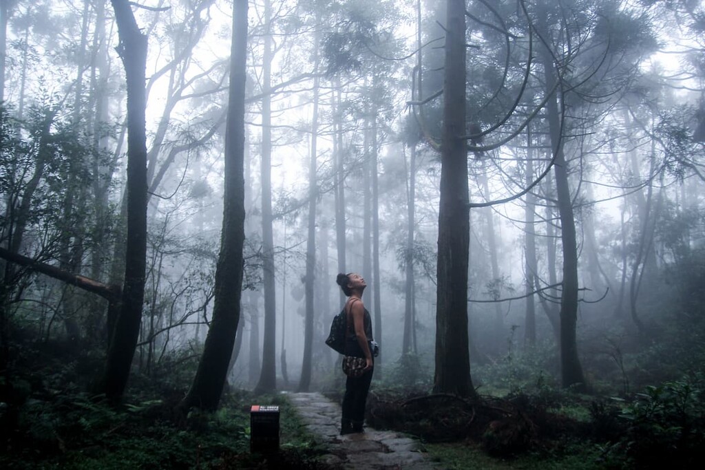
The mountain road divert into two paths; the right path heads uphill towards Meihuashan (梅花山) and Wuzhishan, while the left course descends towards the Shuangxigou Ancient Road. This pristine mountain trail features the incredibly still and calming tranquillity of being totally immersed in nature as the trees line the forest sky and the dead leaves pave a crunchy path up and down the gentle mountain slopes.
The murmuring waters of the Shuangxi Stream lightly bubble and gurgle as the stream makes its way down the mountain, providing the soothing sound of gently moving water as you hike.
Hikers then make their way toward Wanxi Industrial Road, where a huge rocky viewpoint is perched. This viewpoint can accommodate up to 20 people who wish to appreciate the view of the meandering Wanxi Industrial Road below.
Hikers can either exit the trail from here, approximately at the 5.5 km (3.4 mi) mark on the Wanxi Industrial Road or return to Bishan Mountain Pass. When returning, hikers have the option of making a detour to Meihuashan, though this doesn’t offer any exceptional views due to the unwaveringly thick and tall silvergrass in the area.
The Nei Shuangxi Nature Park (內雙溪森林自然中心) encompasses 104 ha (257 acres) of temperate broadleaf forest and ecologically diverse land. One section of the nature park features 0.3 ha (0.7 acres) of a medicinal herb garden, such as herbal tea plants, 12 zodiac medicinal herbs, and native medicinal herbs.
Common poisonous plants are featured to educate visitors on the dangers of accidentally consuming these plants. Meanwhile, fruit-bearing trees offering health benefits further inform visitors on treating their ailments with natural fruit.
The nature park offers several viewing decks, which provide sublime views of the sinuous rivers and verdant valleys below, with the mountains of Daluntoushan (大崙頭山), Dalunweishan (大崙尾山), and Yuanshanzishan (圓山仔山) in clear sight. The viewing platform on the hiking trail is constructed from black sandalwood, which stands at 6 metres (20 ft) tall, a bold view in and of itself.
During the springtime, the gardens of Nei Shuangxi Nature Park bloom to life as lavender, iris, and African lilies unfurl and grace the greenery with delicate pastels.
Fengguizui is prized for its scenic viewpoint, from which hikers can locate Keelung Island (基隆嶼) and Keelung Mountain (基隆山) in the distance. This 6.4 km (4 mi) trail stretches between Fengguizui (風櫃嘴) in the south to Qingtiangang pastures in the north.
As hikers embark towards Qingtiangang (擎天崗), a field of feathery silvergrass sways collectively, creating nature’s dance against the howling wind. The windswept landscape forms a stark contrast to the still and calm atmosphere of the ancient mountain roads. The force of nature is evident here in the hustling wind that drowns out any surrounding sounds as it ripples and whistles through the elongated spindly grass.
The stone paths ascend along the ridgelines of Shitiling (石梯嶺), where views of Dajianhoushan (大尖後山), Huangzuishan (磺嘴山), and Dajianshan (大尖山) are displayed. The summit of Shitiling at 862 metres (2 828 ft) is the highest point of the trail. Moving further onwards, hikers encounter a barrage of silvergrass, signalling the trek to Qingtiangang is drawing near. Passing Jinbaoli Gate, hikers soon glimpse the vast low-lying fields dotted with cows and water buffalo grazing on the fertile ground.
Hikers can end their trek in Qingtiangang or trek back to Fengguizui by frequenting the mountain trail of Shitiling, making the total mileage of the lengthy hike 12.8 km (8 mi).
While Xinshan (新山) does not fall in the proximity of the Upper Masu River Special Conservation Area, it leads a trail to Youruishan, the easternmost extension or ‘finger’ of Wuzhishan. Hikers begin the hike at the Baoxian Road Trailhead, from where hikers trek for 3.2 kilometres (1.9 miles) to Dream Lake (夢湖), which rests on the southern slope of Xinshan.
Dream Lake is a gorgeously picturesque lake, with a light layer of fog hovering over its still aquamarine surface in the afternoon, creating a somewhat dreamlike scene. Hikers set forth towards the summit of Xinshan, surveying the TaiPower Tower erected on the western slope of Xinshan. Xinshan is a notoriously challenging mountain to scale due to the steep, sharp boulders that rest near the summit.
Hikers will then need to use rope assists to pull themselves up the 60 degree slopes of this rock-covered peak to the summit where they can appreciate the expansive views of Wuzhishan, Youruishan, Shisikengshan (十四坑山), and the Xizhi District of New Taipei City.
Hikers then embark towards Xinshan East Ridge (新山東稜), a forest area bathed in the emerald hue of wild and unruly foliage, which leads to the base of Xinshan. Descending the mountain in parts of the clearing, hikers can distinguish Keelung Island in the distance.
As hikers now cross the mountain pass that leads to Youruishan, they may start to hear echoes of military songs from the Wuzhishan Military Cemetery. At the viewing platform on the mountain pass, hikers can appreciate the striking feature of face-shaped rock (人面岩) protruding from the verdant cliffs along the trail.
Troupes of silvergrass welcome hikers to the incline of Youruishan, as hikers have plenty of opportunities to stop at the viewing platforms along the course. From the summit of Youruishan, hikers can locate Qixingshan (七星山) in the northwest, the iconic skyscraper of Taipei 101 in the south, and the coastal fishing harbours of Yehliu (野柳) to the east.
Hikers can end the hike at the Wuzhishan Military Cemetery, or if they are brave enough, turn around and trek back to the start of the trail, scaling Xinshan once again in the process.
Due to Upper Masu River Special Conservation Area’s proximity to Taipei, visitors can enjoy both Taiwan's capital city and its fantastic natural environment in one trip. New Taipei City offers equal amounts of fascinating appeal with the added benefit of being located near enough to Taipei City for an occasional change of pace and scenery.
Taipei City is the capital of Taiwan. It is home to more than 2.6 million people in its urban core while more than 7 million live in its greater metropolitan area. This makes Taipei City the 40th largest metropolitan area in the world.

The National Palace Museum is situated in the northern Shilin District (士林區) of Taipei City, close to the Upper Masu River Special Conservation Area. As one of the most well-known museums in Asia, it holds an assortment of 700,000 artefacts as well as the former collection of Beijing's Forbidden City. The building itself embodies a stately grandeur through its enormous presence and traditional Chinese architecture.
The buzzing and oh-so-popular Shilin Night Market, and its equally electrifying Raohe Night Market, are situated in north Taipei, in the districts of Shilin (士林區) and Songshan (松山區), respectively. Both of these top-rated night markets awaken all of one's senses. Fascinatingly foreign foods are haphazardly paraded along the food booths, offering an intriguing smell as a joyous din of merry food vendors efficiently serve their eager patrons.
Try the sweetly smooth papaya milk or take a bite of the salty squid fried to perfection. Have a bite of the local Taiwan delicacies such as the black pepper bun, deep-fried potato spirals, stinky tofu, and grilled boar sausage.
For a more peaceful experience, Da'an Forest Park occupies a central position in Taipei's Da'an District (大安區). This park occupies 26 ha (64 ac) of land and is renowned for its pleasant ambience, and the abundance of camphor, ficus, and maple trees add to its forest-like appearance. Many residents visit this park to exercise along the shaded trails or take in the lush environment by picnicking or lounging on the grass.
Another popular attraction for visitors seeking a great workout is climbing the nearby city mountain of Elephant Mountain, or otherwise known as Xiangshan (象山), in the eastern district of Xinyi (信義區). Visitors climb a series of steps for 1.5 km (0.9 mi) up the mountain to admire the impressive views of Taipei Basin, with the iconic Taipei101 skyscraper standing in clear sight. The climb down the hill is not as gruelling, but the combination of exercise and grand views is worth the journey.
Probably one of the most noteworthy and popular outdoor attractions of Taipei City is Yangmingshan National Park. A mishmash of mountains, forests, fumaroles, flower fields, ancient paths, and hot springs, Yangmingshan National Park has something to please everyone from multi-peak hiking trails, leisurely walking routes and public thermal baths.
Home to more than 4 million people, New Taipei City is the special municipality and most populous city that surrounds the island’s capital, Taipei City.
The dormant volcanic peak of Qixingshan is one of the main attractions; however, visitors are treated with ample choice to discover this national park that fits their interests.

Tamsui Fisherman's Wharf in the western district of Tamsui (淡水區) is favoured by many. Tamsui Lover's Bridge, unveiled on Valentine's Day in 2003, attracts couples to this area for this reason. The bridge is most vibrant at night as it is illuminated in a variety of colours. From the bridge, visitors can overlook the river port holding 150 fishing boats.
Locals consider it the perfect spot to witness the dazzling sunrise and sunset. A 300 meter (984 ft) walkway spans across the waterfront, where visitors can take a leisurely stroll along the water's edge, appreciating the vast expanse of water stretching from the waterfront to the northern waterbody of the Taiwan Strait and the immense East China Sea.
The Wuji Tianyuan Temple, also situated in Tamsui District, is a well-favoured cherry blossom-viewing location in March and April. The combination of romantic rose-coloured blooms framing the rust roofed circular five-tiered Taoist temple is both elegant and striking. Visitors can stroll along one of the many charming cherry blossom-lined paths and appreciate the picturesque landscape.
Situated in the south of New Taipei City, the gorgeously picturesque Wulai Scenic Area is a charming mountain village famed for its hot springs, waterfall, and scenic beauty. Wulai Waterfall is an imposing 80-metre (262 ft) silken water feature. The thermal waters of the hot spring are both colourless and odourless and contain carbonic acid.
Visitors can take a ride on the 'trail train,' which offers glimpses of the stunning scenery of the mountains and valleys below. In addition, a cultural center in the area provides insight into the traditions and customs of the Indigenous Atayal community.
A day trip to the last stop on Taipei MRT's green line greets one with the outdoor playground of Bitan Scenic Area in Taipei's southern district of Xindian (新店區). The sea-green Xindian River is the core feature of this area, as the grand suspension bridge straddles over the river, which is usually brimming with paddle boats on the weekend. Visitors can hike the forest trails of the shrubby emerald hills that line the river and from where sweeping panoramas of the river and valley below.
From the major Taiwanese cities of Kaohsiung, Tainan, Chiayi, Taichung, Hsinchu, and Taoyuan, take the Taiwan High Speed Rail (HSR) or local express train (TRA) to Taipei Main Station.
From here, board the MRT red line to Jiantan MRT Station. Take the S1 bus from Jiantan MRT Station and alight at Nei Shuangxi stop.
Visitors can also rent a car or scooter to visit the Upper Masu River Special Conservation Area. From Taipei, it is a 15 km (9 mi) drive to the Nei Shuangxi Nature Park or a 27 km (17 mi) journey to the Wuzhishan Military Cemetery.


The highest peak in Upper Mayun River Special Conservation Area is Chepingliaoshan, at 699 m.
Notable peaks in Upper Mayun River Special Conservation Area include Chepingliaoshan, Wuzhishan, Chepingliao Shan, Neishuangxishan and Xiangduishan.


