
Scan the QR code and open PeakVisor on your phone
Guanyin Coast Major Wildlife Habitat has 4 named peaks. The highest is Nan Shan at 614 m. Other notable peaks include Hai’an Shan, Zhōng Rǔ Shí Qiào Bì and Aowei Shan.
A remote fertile forest along northern Taiwan’s coastline is an important habitat for wildlife and many plant species. Nan Shan (南山) is the tallest of the four named mountains at 614 meters (2,014 ft), while the most prominent peak is Hai’an Shan (海岸山), measuring 422 meters (1,385 ft).
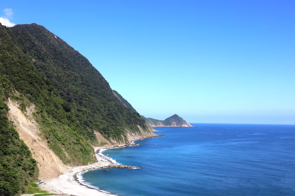
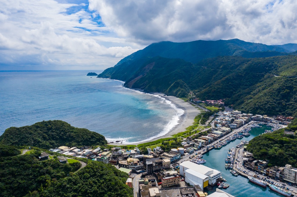
The Guanyin Coast Major Wildlife Habitat (觀音海岸野生動物重要棲息環境) is situated in Nan’oa Township (南澳鄉) in Yilan County (宜蘭縣). The reserve lies on the eastern sloping coastal hills and valleys that run towards the Pacific Ocean shore. Covering an area of 519 ha (1,282 ac), the distance from north to south spans 8.5 km (5 mi). Its shape resembles a belt along Nan’ao Township’s coast.
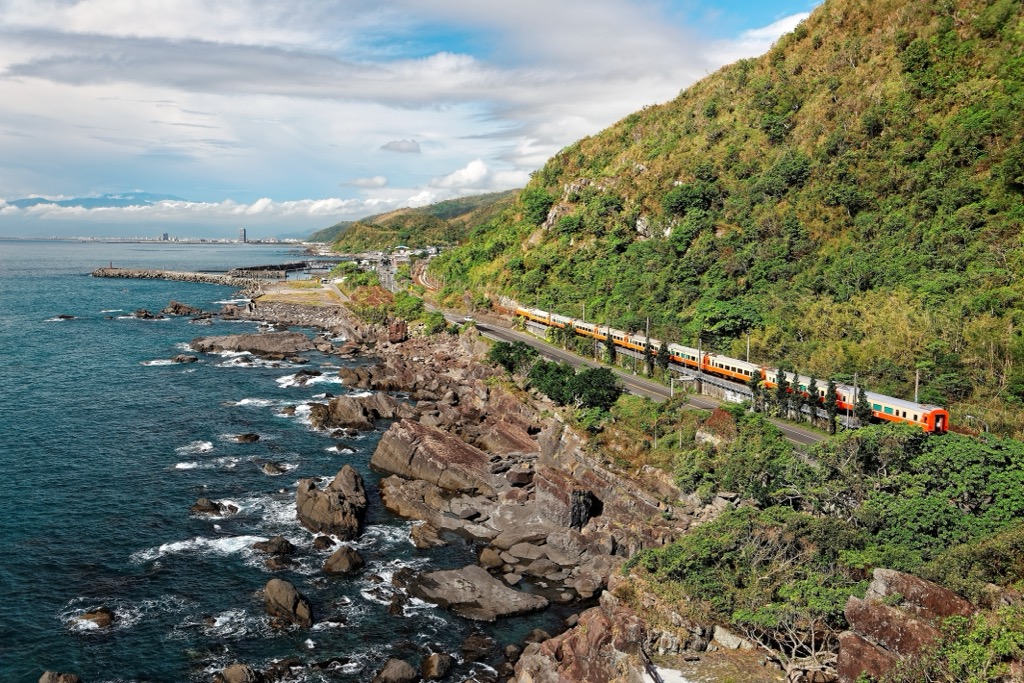
While the Suhua Highway dissects the primitive wildlife habitat, the area has little human interference. This is mainly due to the hilly landscape with dense shrubbery and thick forests, which make it somewhat inaccessible to road users.
Being on Taiwan’s east coast, the yearly rainfall average lies in the mid-to-high levels of 2,400 mm (94 in). Some months are rainier than others, showering Guanyin Coast Major Wildlife Habitat with catastrophic rainfall. These usually result in landslides and collapses on high cliffs, so it’s never a good idea to visit during the rainy months or during typhoons.
The coastal region has gentle, rolling hills of smaller stature than central Taiwan’s jagged giants. Belonging to the northernmost section of the Central Mountain Range (中央山脈), the mountains are smaller, hardly measuring above 1,000 meters (3,281 ft). Aowei Shan (澳尾山) and Zhong Ru Shi Qiao Bi (鐘乳石峭壁) are the other two named hills in the region.
Although the region is secluded, there are notable areas nearby. In the north is one of the world’s only coldwater springs, Sua’o Cold Spring (蘇澳冷泉). Situated northwest is the stunning Taipingshan National Forest (太平山國家森林遊樂區), one of Taiwan’s three largest logging bases.
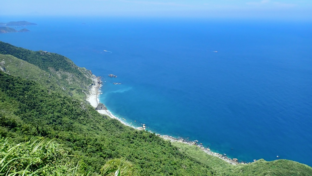
In the south is eastern Taiwan’s scenic Qingshui Cliffs (清水斷崖), where the emerald land suddenly drops into the sapphire sea. While the world’s largest ocean, the Pacific Ocean, laps on Nan’ao Township’s seashore.
Nan Shan and the three other name peaks all belong to the Central Mountain Range. Taiwan’s longest sierra stretches for 270 km (168 mi) from southern Pingtung County (屏東縣) to northern Yilan’s coastline. Peaks at these two ends are usually much smaller than the giant and jagged mountains in Taiwan’s central backcountry.
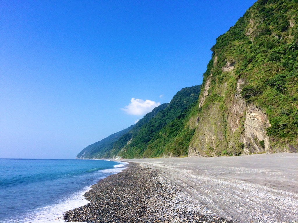
Along the shore, Guanyin Coast’s beaches are composed of alluvial gravel of a striking dark grey appearance. A mix of black, quartz, and chloride schists and marble from the Permian Period comprise the Ewen Cliff’s rock bed.
Four major plant species are identified in Guanyin Coast Major Wildlife Habitat. They are Boehmeria platyphylla D. Don belonging to the nettle family, Coriaria shrubbery, the flowering Debregeasia orientalis, and the grassy Arundo donax. There are mainly forests of Taiwan alder, banyan and phoebe trees.
The forests are alive with birdlife, from crested goshawks, black bulbul, and the Taiwan blue magpie. Other wildlife thrives in the wildlife habitat, such as Taiwan macaques, red-bellied squirrels, and crabs.
Nan’ao Township is Taiwan’s largest township, with an area of 74,065 ha (183,019 ac). Most of its residents belong to the Atayal tribe, but there are residents, particularly in the Aohua Village (澳花村), who still speak Japanese. This is because locals in this remote community were forced to speak Japanese during the Japanese Occupation Era. Even when the Japanese retreated from Taiwan, the language stayed behind.
A few years before Japan’s invasion, the Qing dynasty sanctioned the construction of roads connecting the north to the south. As eastern Taiwan was and is still somewhat inaccessible, roads were built to increase the line of defence. What prompted this was the Mudan Incident in southern Taiwan. A shipwreck stranded 66 Ryukyuan sailors who ventured to safety on land.
However, the Paiwan people of southern Taiwan, known for being unwelcoming to outsiders, felt the Ryukyuan sailors trespassed on their land and killed 54 of them. While Japan had not yet invaded Taiwan, they were angry at the Qing dynasty, who did not take punish the Paiwan people. Which then resulted in the Japanese avenging the Paiwan people by killing them.
The major hiking trails and areas to explore in and around the Guanyin Coast Major Wildlife Habitat are:
Accessible only at low tide, the Nan’ao Mysterious Beach Trail (南澳神秘海灘步道) is a 7km (4 mi) stretch of gravel shores bordered at one side by steep, sharp cliffs. Along the beach trail, you’ll find sea-eroded caves in the coastal cliffs from millions of years of weathering.
Also known as the Suhua Ancient Road, locals would trek the path to venture south towards Hualien (花莲市) and Qilai (䓫萊村). Near the end of the route, around the 5.5 km (3.4 mi) mark, you’ll notice the largest cave that is 10 meters (33 ft) deep. Swallows use this secluded grotto to nest, so you may notice a flurry of activity on your coastal walk.
While back on the shore, you’ll come across marble stone walls, striking rock formations, and various kinds of pebbles dotted along the beach. It’s a beautifully scenic walk, taking in the dramatic cliffs overgrown with plants and the wide, open sea echoing its whispering rhythm.
Falling outside Guanyin Coast Major Wildlife Habitat’s scope is the ravaging hill of Yuenshan (御恩山) and the alpine Mysterious Lake (神秘湖). The 6.5 km (4 mi) trail leads you up Yuenshan and towards the natural pond of rich biodiversity.
You’ll venture through aromatic cedar groves as you ascend Yuenshan’s gentle mound. Although the forested peak obscures views from the mountaintop, the highlight of the trek is Mysterious Lake. As cloud cover usually hovers above the surface, looking mysterious and eerie, that’s how the lake got its name.
Look out for frogs hopping around Mysterious Lake’s perimeters and many bird species that perch in the forest trees. It’s a calming melody on the mountain with the chorus of birdsong. Walk on the wooden boardwalks that encircle the lake to view the flourishing aquatic plants and admire the still water against the dense woodlands.
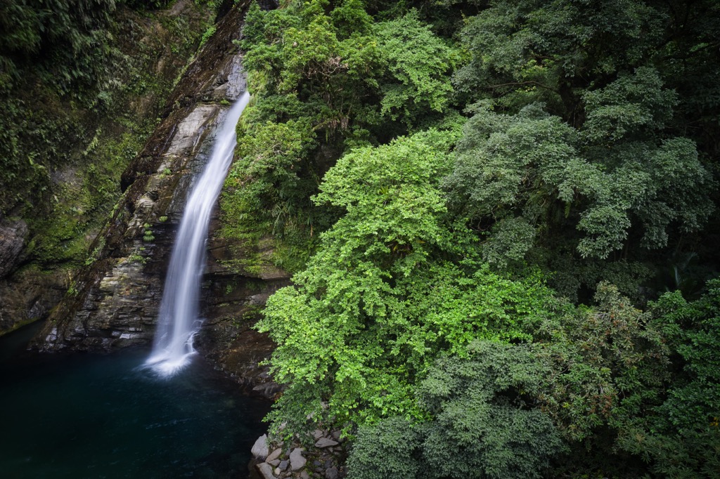
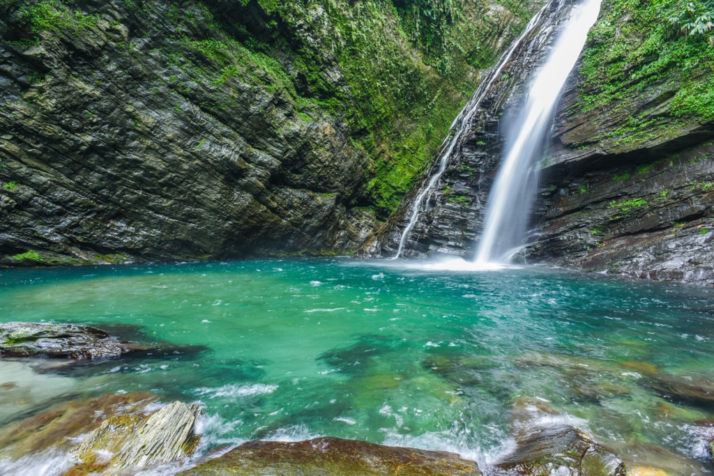
One of Yilan’s most stunning landmarks is the Aohua Waterfall (澳花瀑布), located in the mountains. Situated in the southernmost settlement in Yilan County, Aohua Village is a Japanese-speaking hamlet comprised of five Taiwanese tribes.
From the entrance, it is only a 300-meter (984 ft) walk to Aohua Waterfall. You’ll hear the 50-meter-high (164 ft) roaring rapids before you see them, but the sight is simply breathtaking. The sunny skies and misty water vapor create a rainbow that suspends over the falls like magic. You’ll feel so small as you admire the giant cascade.
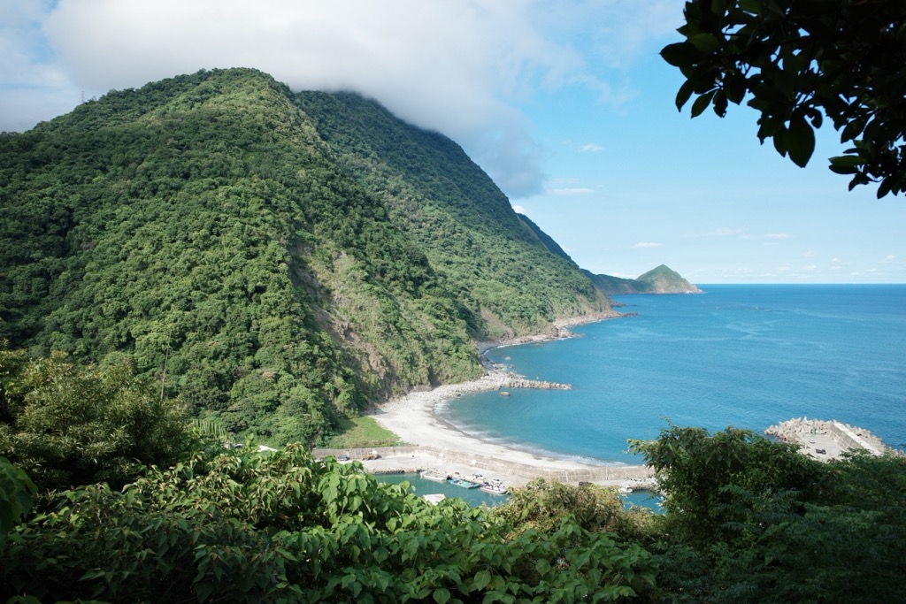
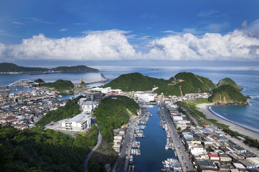
Located north of Nan’ao Township is the coastal Zhaoyang National Trail (朝陽國家步道), a cliff walk amongst dense forestry and dazzling ocean views. While only 2.2 km (1.4 mi) long, the terrain is steep, with constant climbing up wooden sleeper stairs. Although it's a short challenge for glorious panoramas once you’ve gained elevation.
As you begin the trail, you’ll be surrounded by boundless foliage. There’s a dense sweetgum forest with a mix of plum and banyan trees. While you cannot see the ocean, you can hear the rolling waves crashing against the shore. Around halfway, you’ll reach an observation deck where you’ll see the vast Pacific Ocean below you.
You’ll encounter another three viewing decks from the leafy trail before you descend towards the Zhaoyang Fishing Port and saunter across to the adjacent gravel beach. Take in the scenic beauty, smell the salty sea air, and listen to the soothing soundtrack of the humming ocean.
Enter a world of luscious emerald foliage as you walk the 3 km (1.8 mi) path of Nan’ao Historic Trail (南澳古道). Used by the Atayal people to venture inland from Nan’ao to Siji Village (四季村) in Datong Township (大同鄉) around 200 years ago, this trail is full of history. It is also a thriving forest road full of lavish plants and dense shrubbery.
While the whole path is 27.5 km (17 mi), the 3 km (1.8 mi) section of the Nan’ao Historic Trail is a walkable route that shows the trail’s historical sights for everyone to see. You’ll observe the ruins of an old suspension bridge along the trail, a Japanese stone monument, and the old foundations of a Japanese guard road.
While the path is interesting, it’s a fascinating forest walk. The overgrown foliage is striking, forming a forest canopy above and a green world of ferns and ground cover plants along the path. One of the most scenic spots is on the suspension bridge, where the Nan River bubbles beneath, bordered by the dense woodlands on either side.
One of Yilan and Taiwan’s wonders is Su’ao Cold Springs, one of two coldwater springs globally. Far rarer than hot springs, it's a wonderful oddity that Yilan holds this wonderful phenomenon. Discover the rejuvenating 72°F (22°C) water containing sodium bicarbonate and carbon dioxide. The bubbles from the carbon dioxide will cling to your skin, giving you the sensation of being in a carbonated bath.
Not only is the experience unique, but there are numerous health benefits attached to it. Cold springs have traditionally been used to treat skin conditions, and locals believe they can also cure intestinal illnesses. Washing your face with mineral-rich water is encouraged by locals, which is also thought to have beautifying properties. Don't miss out on this once-in-a-lifetime chance to cleanse your mind, body, and skin at Su'ao Cold Springs.
Two places that you can stay in Yilan County are Yilan City (宜蘭市) and Datong Township (大同鄉) when visiting the Guanyin Coast Major Wildlife Habitat. From city comforts to outdoor adventuring, Yilan City and Datong Township are near each other if you want to combine the two.
A short drive south of Taipei (臺北市), residents of Taiwan’s capital love weekend trips to Yilan City when they want to get away from it all. With its gorgeous coastline, picturesque landscapes, and laid-back lifestyle, it's the ideal place to relax, unwind, and take it easy.
For a little something different, visit the Tangweiguo Hot Spring Park (湯圍溝溫泉公園). Dip your feet into the steaming hot stream where fish nibble the dead skin cells off your toes and heels. Or you can grab a cup of coffee and soak your feet in the adjacent fishless foot bath. You can also emerge your whole body in a hot spring water bath as you feel all your tension melt away.
Afterwards, you may feel hungry after your relaxing soak. Located in the heart of the city is Dongmen Night Market (東門夜市), one of Yilan City’s most popular attractions. Open every night, you can find a wide variety of street food, clothing, and souvenirs. Sample traditional Taiwanese delicacies such as stinky tofu, oyster omelet, and bubble tea, as well as international cuisine. The market is also known for its lively atmosphere, with vendors shouting out their wares and music filling the air.
For a trip to the beach, visit Yongzhen Seaside Park (永鎮海濱公園), where you can picnic at tables away from the sand and then play in the sapphire surf afterwards. While you’re enjoying a blissful lounge on the beach, take in the stunning view of the ocean with Guishan Island (龜山島) in the distance. Looking like a turtle swimming at sea, Guishan Island is named after this reptilian hard-shelled creature.

If you want to explore Taiwan’s scenic nature, Datong Township packs a punch of stunning environments. You can visit two national forests and a wildlife reserve and get lost in the thick of the outdoors, wandering from leafy trail to trail.
Pay a visit to one of Taiwan’s famous former logging bases at Taipingshan National Forest. From majestic mountains to simmering springs and fertile forests, you’ll find yourself in heaven on earth. Meander the many scenic trails that pass through the misty woodlands of beech, cypress, and hemlock. Uncover Taipingshan’s historical past with paths leading you to abandoned rail tracks, where you’ll find disused trolleys and axles.

For another walk in the woods, head to the nearby Mingchi Forest Recreation Area (明池國家森林遊樂區). Set in the hills at an elevation of 1,200 to 1,700 meters (3,937 to 5,577 ft), breathe in the fresh mountain air and walk through dense virgin forests where the sunlight hardly reaches. Birdlife thrives in this primitive grove, which is great for bird spotting. Make your way to Mingchi Lake for a picturesque and peaceful setting against the verdant mountains and forest.
Finally, visit Qilan Wildlife Reserve (棲蘭野生動物重要棲息環境) to walk amongst 51 cypress trees aged over 1,000 years and towering above younger forest growth. Tread deeper into the woodlands to embark on a forest bathing trail amongst fragrant cedars and yew for a restorative walk that leaves you feeling awakened and rejuvenated. In springtime, look out for cherry blossoms that erupt pink pastels against the forest green.
To reach Guanyin Coast Major Wildlife Habitat, start your journey in Taipei. Take the local express train (TRA) from Taipei Main Station to Nan’ao Station. From the station, it’s a 2.5 km (1.5 mi) journey to Guanyin Coast Major Wildlife Habitat. You can walk from the station or take a taxi. If you prefer to use your own transport, you can hire a car or scooter in Taipei or Yilan. It is a 93 km (58 mi) and 45 km (28 mi) journey, respectively.


The highest peak in Guanyin Coast Major Wildlife Habitat is Nan Shan, at 614 m.
Notable peaks in Guanyin Coast Major Wildlife Habitat include Nan Shan, Hai’an Shan, Zhōng Rǔ Shí Qiào Bì and Aowei Shan.


