
Scan the QR code and open PeakVisor on your phone
Zhiben National Forest Recreation Area has 1 named peak. The highest is Zhiben Shan at 1,193 m.
Zhiben National Forest Recreation Area (知本國家森林遊樂區) is a subtropical broadleaf sanctuary that’s enveloped in evergreen mountainous scenery and features a winding. The recreation area is located in eastern Taiwan and it contains only one named peak: Zhiben Shan (知本山), which has an elevation of 1,193 meters (3,914 ft).
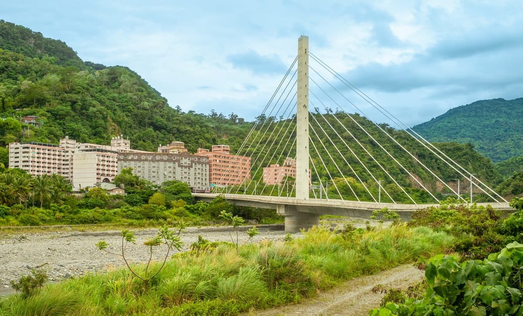
Zhiben National Forest Recreation Area is situated in the Beinan Township (卑南鄉) of Taitung County (臺東縣). This small recreation area contains 111 ha (274 acres) of land.
Southeastern Taiwan is generally flatter than both central and northern Taiwan; thus, Zhiben forest doesn’t feature very rugged landscapes and its overall elevation ranges mostly between 125 to 550 meters (40 to 1,804 ft). The exception is the recreation area’s high point, Zhiben Shan, which has an elevation of 1,193 meters (3,914 ft).
Additionally, Zhiben forest enjoys a pleasant average annual temperature of 22°C (72°F). The rainy summer months herald Taiwan’s annual typhoons, which account for 55 percent of Zhiben’s yearly rainfall.
As a result, southeastern Taiwan’s signature warmth and humidity aid the growth of numerous subtropical plant species, particularly the white banyan (also known as the weeping fig), Taiwan phalaenopsis, and a variety of ferns.
Known for its incredible landscape, the Zhiben River (知本溪) flows its cobalt waters amongst verdant undulating gentle hills of its namesake national forest recreation area. The highly acclaimed Zhiben Hot Springs (知本溫泉) also lies just downstream of the recreation area near the coast of Taitung.
Accordingly, Zhiben forest offers many scenic trails for you to discover, from plush forest bathing paths to a short, steep hilly course overlooking the Pacific Ocean. Furthermore, you can find a herb garden with over 50 herbaceous plant species and soak your feet in the mountain stream’s spring water.
Zhiben National Forest Recreation Area is a prime spot for nature lovers and hiking enthusiasts. It also offers great birdwatching and butterfly spotting opportunities.
Other areas of interest that surround Zhiben forest include Dawu Mountain Nature Reserve (大武山自然保留區) in the west and Shuanggui Lake Major Wildlife Habitat (雙鬼湖野生動物重要棲息環境) in the north. Both Taitung City and the southern end of the Huadong Coastal Reserve (花東沿海保護區) also lie to the east.
Although it is located in the far southeastern part of Taiwan, Zhiben Shan is actually part of the Central Mountain Range (中央山脈).
The Central Mountain Range is Taiwan’s longest chain of peaks as it is 395 km (245 mi) in length. As most of Taiwan’s 100 Peaks are located in central Taiwan, the Central Mountain Range’s intense ruggedness tapers as it reaches its termini in northern and southern Taiwan.
Zhiben’s landscape features undulating hills that run roughly from the southeast to the northwest. Its bedrock consists primarily of shale and sandstone of the Tertiary era.
Zhiben National Forest Recreation Area’s plant life is characterized by subtropical broadleaf plants that retain their vibrant greenery year-round in the dense, sheltered forest.
Taitung cycads, white banyan, camphor, and mahogany trees populate Zhiben’s forests with their lush foliage. Maple trees also grow in Zhiben, turning the woodlands into a flash of gold in the autumn months.
A wealth of wildflowers is one of Zhiben forest’s main attractions. The native Taiwan phalaenopsis, rhododendron, and wisteria all command a stirringly scenic sight in the recreation area during the springtime.
Furthermore, the recreation area is home to a thriving population of birds. Common bird sightings include the black bulbul, crested goshawk, and the black-naped blue flycatcher.
As the region is also located close to the Zhiben River, there are also many amphibians and reptiles in the area, such as the Japanese tree frog and Taiwan grass lizard.
Additionally, butterflies are known to roam the flowering buds of the recreation area in the spring and summertime. Swallowtails are particularly prominent in the region.
Taitung County’s Beinan Township is the ancestral home of two tribes: the Puyuma and the Rukai tribes. While these two tribes historically coexisted in Beinan Township, the Puyuma tribe is quite a bit larger in terms of its total member population.
Known as fearless warriors, Puyuma males undergo a rite of passage to become men worthy of battle. On the brink of manhood, 20-year-old Puyuma men gather to perform traditional rituals and learn combative training techniques to raise their status from boyhood to men. For this reason, the Japanese considered the Puyuma to be Taiwan’s strongest tribe, and they often enlisted Puyuma men in their military.
Ironically, the Puyuma tribe has a matrilineal culture, whereby the females are considered the head of the family, and married men take on their wife’s surname. However, despite (or perhaps because of) their matrilineal practices, the Puyuma have long been known as incredible warriors.
Zhiben National Forest Recreation Area is home to an excellent collection of hiking trails. Here are some of the best hikes to check out during your next visit to the region.
Zhiben's 1.8 km (1.1 mi) long Forest Bathing Trail bursts with phytoncide from the lush woodlands of Taiwan ash, mahogany, and camphor trees.
If you seek tranquility and solitude amongst nature, the leafy Forest Bathing Trail is the perfect path to wander. As you inhale phytoncide's calming effects, you will notice your body releasing tension as your stress hormones lower. In turn, many people feel invigorated and relaxed on this trail.
The Forest Bathing Trail's path is very gentle and you can enjoy the melodious tweeting of the local birdlife as you make your way down the trail. This also makes the Forest Bathing Trail a popular choice for families with young children.
While the Forest Bathing Trail is relatively flat, the 1 km (0.6 mi) shy Haohanpo Trail is one of the steepest paths in the national forest recreation area with a drop of 150 meters (492 ft). To follow this trail, you will climb the 1,710 stairs that ascend the Hero Slope, which is an infamously steep, albeit short, incline.
Several towering banyan trees shade the trail’s staircase, which leads to the large ‘thousand root banyan tree.’ This tree boasts a plethora of hanging aerial offshoots that create an infinite web of branches. At the top of the hill, you can admire the Pacific Ocean’s endless cerulean cadence while gaining a birds-eye view of Zhiben Hot Springs.
To marvel at Zhiben’s assortment of herbs, venture on the Qilixiang Trail, which is an extension of the Forest Bathing Trail. One of the Qilixiang Trail highlights is the trail’s bridges and stone walls, which surround the Zhiben River and are constructed from the forest’s fallen trees and rocks.
This trail also takes you to an herb garden, which features medicinal herbs, tea plants, and cooking herbs. The herbal garden is also bordered by verdant hills with nearby mountains in the background, all of which add to the region’s emerald landscape.
If you’re looking for a short, yet fun hike, consider the 2 km (1.2 mi) Rongyin Trail. The path winds up the Zhiben Shan’s leafy slope, passing a mixture of tree communities, such as the soapberry, Taiwan beech, sweetgum, and eucalyptus. A group of several white banyan trees that are over 100 years old also add an element of enchantment to the trail.
Taiwan macaques are often spotted grazing along this trail. In addition, butterfly sightings are popular in the spring and summer months when the path is awash with vibrant wildflowers. At the highest point of the trail, at 455 meters (1,493 ft), you can also see the nearby Zhiben Hot Spring.
Once a riverside meeting place of the Puyuma people, Zhiben Hot Springs was commercialized during the Japanese Occupation Era when the Japanese built public baths surrounding the thermal water source for people to enjoy. This development, however, privatized the location of the natural hot spring, making it an exclusive resort that was only open to certain people.
Located near Zhiben's luxurious forest, Zhiben Hot Spring is known for its idyllic setting in Taitung’s rustic countryside. The sodium bicarbonate-infused waters of the hot springs simmer at a temperature around 45 to 55°C (113 to 131°F) and are renowned for what’s believed to be their ability to cleanse the skin.
As Zhiben Hot Springs is situated in a Puyuma hotspot, local cuisines are readily available for you to sample. You could nibble on a shijia (sugar apple), chew a doughy rice dumpling, or daringly devour fried wild rat with basil.
Located just a short walk from the tranquility of Zhiben Hot Springs is the majestic Baiyu Falls (白玉瀑布). This trail leads through dense forests until you reach a clearing where you can see the waterfall first-hand.
The falls drop down a 50-meter-high (164 ft) cliff, which features ample foliage. That said, if you want to view Baiyu Falls in all its splendid glory, be sure to visit during the summertime when regional water levels are at their highest.
As eastern Taiwan is notoriously isolated from its western counterpart due to the Central Mountain Range, visitors to Zhiben only have a few accommodation options. Two of the best places to check out during your trip to the recreation area are Taitung City (臺東巿) and Yuli (玉里镇), the latter of which is a small township in eastern Taiwan.
Taitung City is a remote city with a rustic charm that’s provided by its gorgeous natural surroundings and coastal location.
If you want to see the city’s wild beauty for yourself, pay a visit to the central Taitung Forest Park, which encompasses 280 ha (692 acres) of dark beefwood trees. In the park, you’ll quickly forget you're located in the heart of Taitung City as you stroll along the verdant trails and visit the idyllic turquoise Pipa Lake. In the distance, you can marvel at the Luye Highland's jagged silhouette, which is juxtaposed against the perfectly sunny blue skies.
Another one of Taitung's scenic attractions is the rolling emerald field patches of the Luye Highlands (鹿野高台). Luye's elevated setting makes it a prime spot for air sports, such as paragliding and hot air ballooning. In fact, Luye Highlands plays host to the crowd-pleasing Taiwan International Balloon Festival in August of each year.
For intrepid travelers wishing to extend their travels even further into eastern Taiwan, a ferry service runs from Taitung's port to the archipelagoes of Green Island (綠島) and Orchid Island (蘭嶼).
Covering a small area of 1,700 ha (2,400 ac) and 4,600 ha (11,366 ac), respectively, these volcanic isles offer pure natural beauty. The coral reef surrounding the islands is unspoiled, the marine life is abundant, and the islands' tropical vegetation is pristine, so any visit to the area is sure to be incredible.
Additionally, one of Taitung's most interesting horticultural areas is the Yuan Sen Applied Botanical Garden (原生應用植物園), which houses an array of Taitung's precious medicinal herbs.
The gardens feature thousands of regionally native plants. Visitors to the garden can enjoy its beautifully landscaped area, which offers unrivaled views of the Pacific Ocean. In addition, Yuan Sen's restaurant serves fresh produce that’s seasoned with local herbs.
Finally, if you want to revel in the more remote areas of Taitung, venture north to the seaside villages of Donghe (東河) and Dulan (都蘭). Both towns are highly favorable surfing spots. Dulan boasts an expansive black sand beach, and it's a lively spot on weekends. Meanwhile, Donghe hosts the annual Taiwan Open National Surfing Championship, which cements its reputation as the island’s top surfing beach.
Yuli is the halfway point of Taiwan’s most scenic drive, which traverses the Huadong Coastal Reserve. While Yuli is located far from any major cities, it offers a whole lot to love, despite its small size.
In fact, Yushan National Park (玉山國家公園) is situated just to the west of Yuli. From the town, you can access the lush Walami Trailhead, which leads to the peak of Yushan (玉山). For many, scaling Yushan is a bucket list adventure as it is the highest point in Taiwan. Yushan National Park also offers a network of trails for hikers of all experience levels.

Even if a summit attempt at Yushan isn’t in the cards for your trip, you can always check out the stunning Nanan Falls. At the falls, you can feel the cool spritz of the 50-meter (164 ft) high cascade tickle your face as you watch the foamy white rapids fall against a layered garden of greenery.
.
Another of Yuli’s top attractions is the conveniently located An Tong Hot Springs (安通溫泉). The spring’s waters bubble at a temperature of 66°C (151°F), and they are believed to help relieve skin ailments and settle indigestion. Additionally, the hot springs offer excellent views of the surrounding landscape.
Finally, the nearby Xiuguluan River (秀姑巒溪) is a hotspot for the thrillseekers, as 24 km (15 mi) of the river is used for whitewater rafting. It is eastern Taiwan’s longest river, and it is the only waterway that flows through the coastal Hai’an Range (海岸山脈). Thus, adventurers to the river can experience the most unspoiled scenery of the region’s steep canyons while making their way down more than 20 incredible rapids.
To get to Zhiben National Forest Recreation Area, take the local express train (TRA) from Taiwan’s major cities to Taitung City.
Once there, make a change and board the train heading to Zhiben Station. Then transfer to the 8129 bus and alight at the Zhiben Hot Springs Stop, which is just a short walk away from Zhiben National Forest Recreation Area.
Alternatively, if you rent a car or a scooter, you can make the 20 km (12 mi) drive from Taitung City to Zhiben National Forest Recreation Area.


The highest peak in Zhiben National Forest Recreation Area is Zhiben Shan, at 1,193 m.
Notable peaks in Zhiben National Forest Recreation Area include Zhiben Shan.


