Scan the QR code and open PeakVisor on your phone
One of 27 parks in the Jefferson County (Colorado) Open Space system, Meyer Ranch Park is located near the town of Conifer in the foothills of the Rocky Mountains. It is a relatively small park, as compared to the other major parks in the mountainous areas of the county, at only 667 acres in area and containing only 4.1 miles of trails. But it is a gem of a park for a number of reasons that I will get into shortly. But first a few words about Open Space Parks and the contribution they make to the recreational infrastructure of Jefferson County and indeed the entire greater Denver metropolitan area. The Open Space system encompasses about 56,000 acres that contain 244 miles of hiking trails, most of them multi-use, meaning that they allow hiking, biking, horseback riding, sledding and cross-country skiing. A dedicated sales tax ensures funding for creation of the parks, their maintenance and for creation of new trails. Admission to the parks is free for all visitors and the parks are very popular, especially on weekends. Facilities, including restrooms, parking lots, picnic areas and trails, are exceptionally clean and well-maintained.
Meyer Ranch Park has only one named mountain – Legault Mountain – which at 9,072 feet is both the highest and most prominent. Due to its higher elevation than most other Open Space parks, as well as its forested terrain providing plenty of shade, this one can be hiked comfortably even in the warmest summer months. The park came into being in 1987 when the Meyer family sold 400 acres of their ranch to Jefferson County, which developed the park and opened it to the public in 1989 after purchasing the additional land. For more information about the interesting history behind the park, please follow this link. The park is located beside U.S. Highway 285, a major route from Denver into the central mountains of Colorado, where considerable mining activity took place in the 19th century. The highway contributes some traffic noise, which is quickly forgotten as you hike further into the park and reach the higher elevations.
The trails here are very easy, and if you combine all of them in a single hike, you will walk no more than about six miles (keep in mind that you will repeat certain segments of the 4.1 miles in order to do this). This is an easy morning hike. My wife and I are used to doing much longer and more strenuous hikes than this, but we always found great satisfaction here because of some unique factors that most hikers here do not know about. With trails being almost entirely in the forest, there is only one viewpoint along one of the trails, which would detract some from coming here. But there is a mountain in this park, Legault Mountain, which can be reached by an unofficial trail (often referred to as a “social” trail). For those willing to put in the extra effort to make this climb, they will be amply rewarded by spectacular panoramic views in all directions.
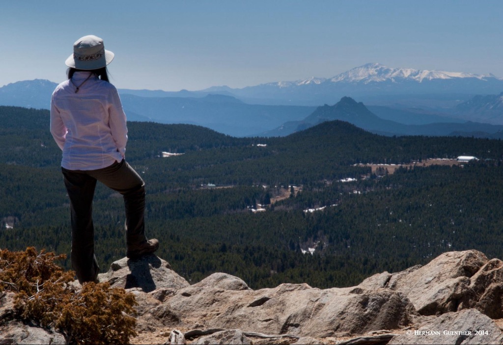
When I first hiked here, I did not know about this mountain, but when I got to the highest point on the trail network, I wandered into an open meadow and saw a rocky summit before me which was hundreds of feet above me and that I just had to explore. So I simply headed in the direction of the peak and looked for a way to get to the top. Though an apparent way to the top became obvious, there was very little evidence of a trail. So I just kept going until I could go no higher – when I got to the summit, I was rewarded with an eyeful of wonderful views in all directions. What a surprise! This was definitely worth the steep climb.
At that time I had no idea that the mountain was actually within the boundaries of the park. As my wife and I made many subsequent hikes to Legault Mountain over the years, we rarely saw anyone else up there, although evidence of others having been there was slowly emerging, to the point where we were seeing evidence of more hikers making the effort. Even so, hiking here only on weekdays, we rarely met anyone else once we got off the maintained trail. Lately, the “social” trail has become much more obvious and I was even told by a park ranger that a formal trail to the top was being considered by the county. That would certainly make a nice improvement to the park, but will also do away with the solitude we used to find on the summit.
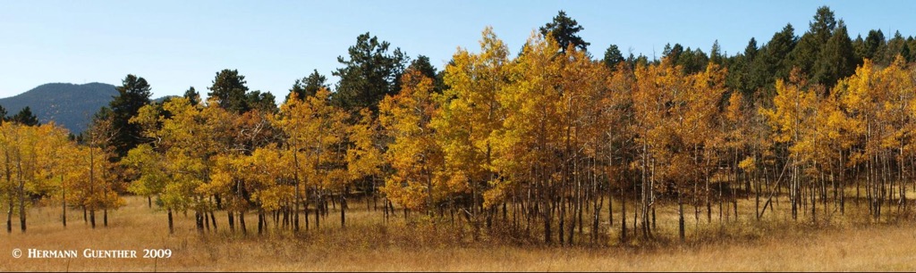
Aside from the spectacular views from the summit of Legault Mountain (actually, there are several sub-summits, each with its own great views), Meyer Ranch Park has several fine groves of aspen trees that infuse the environment here with vibrant autumn colors.
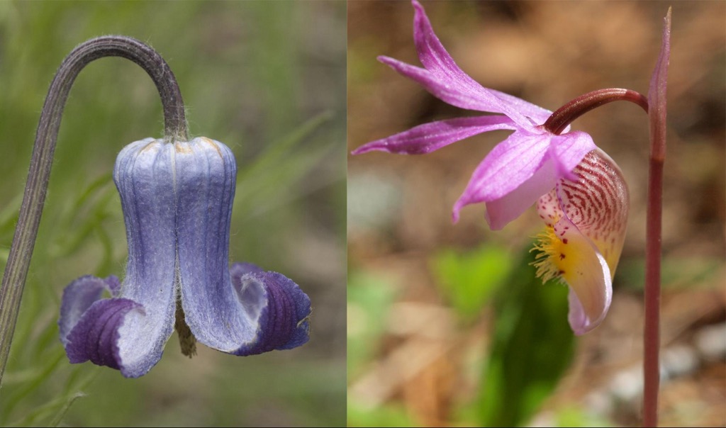
This park is also home to many varieties of wildflowers in late spring and through much of the summer. We came across one variety that is rarely seen by most hikers – they are so small that most hikers or bikers go past them so fast that they miss them. Our wildflower guidebook states that “you should consider yourself very lucky if you see” the Calypso Orchid, which thrives only in a unique combination of terrain and soil types. Once we saw a few here for the first time, we always tried to get back to the same spot at the same time of year – usually late May or early June. We have never seen these anywhere else.
There is only one trailhead in Meyer Ranch Park and it is right beside Highway 285 where there is ample parking area – an overflow parking lot is located on the opposite side of the highway for those days when the park sees lots of visitors. This can be reached via an underpass so that people don’t have to cross the busy highway on which the traffic moves rather fast. The Owl’s Perch Trail starts here. A few hundred yards from the trailhead is an information kiosk and a bit further along is a restroom facility as well as a picnic area. This part of the trail passes over a large sloping meadow that becomes a favorite sledding area in the winter.
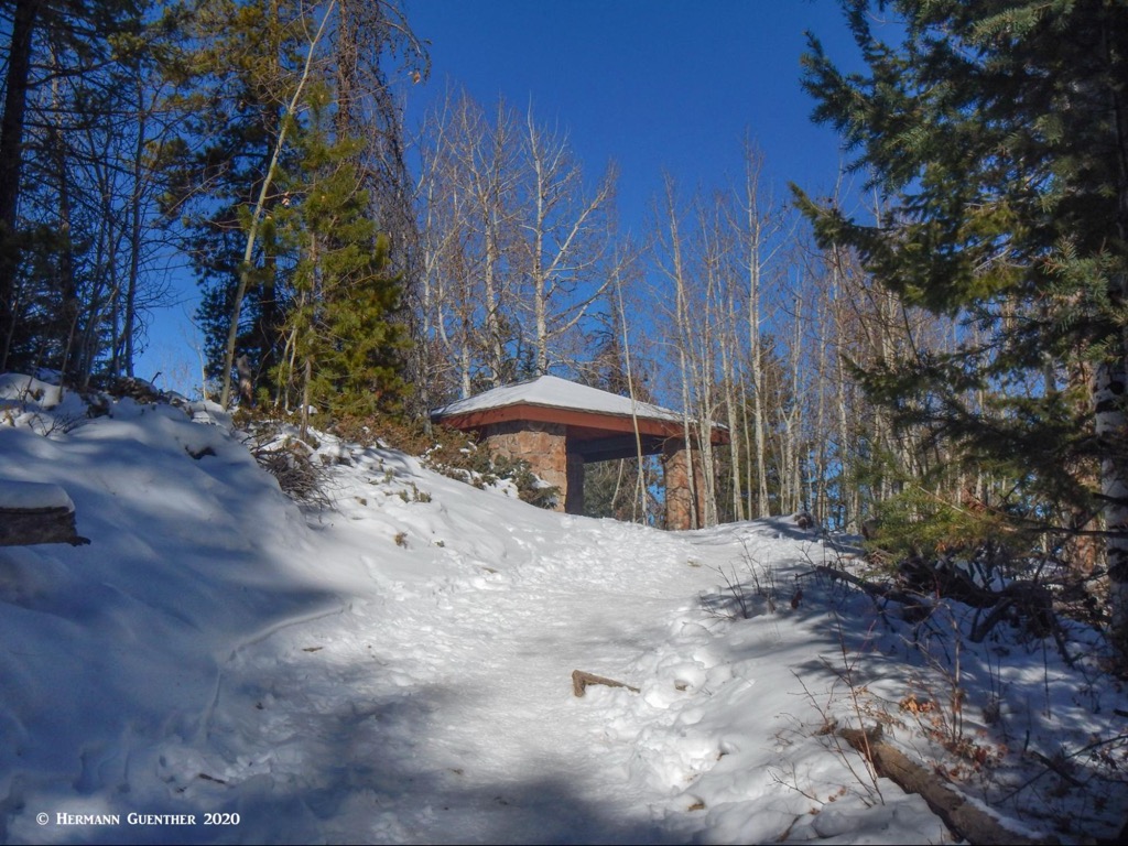
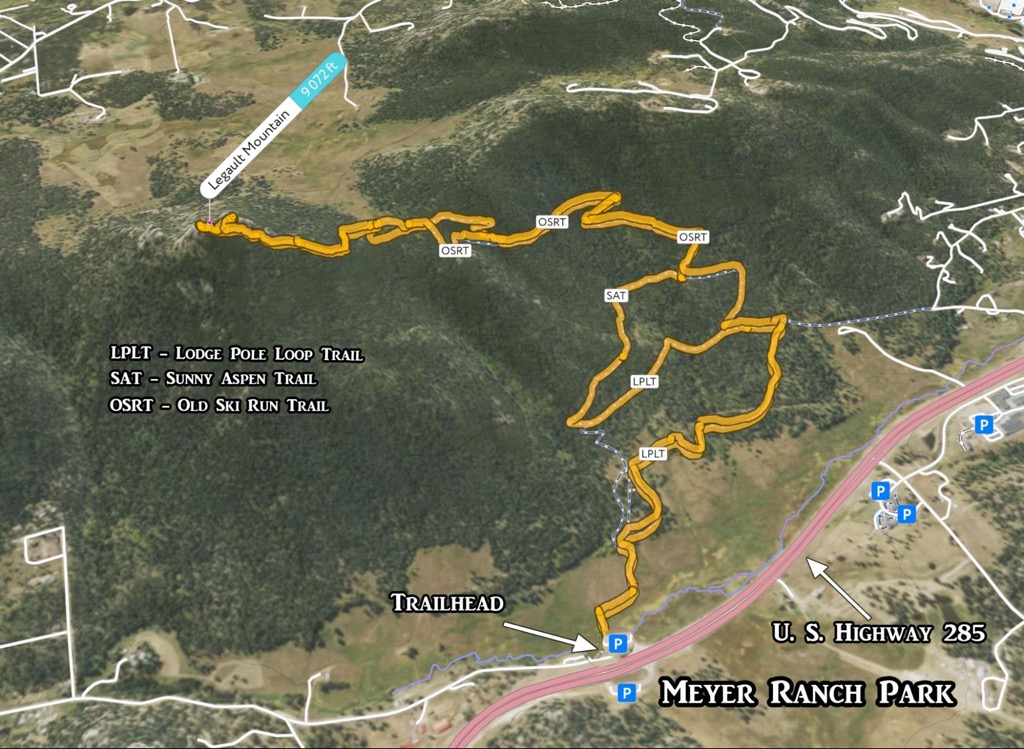
After passing through the picnic area, the Owl’s Perch Trail ends and merges into the Lodge Pole Loop Trail, which as the name implies, is a complete loop of 1.2 miles. It is by far the easiest trail in the park. The Lodge Pole Loop Trail joins the Sunny Aspen Trail at two junctions about 0.4 miles apart. The latter takes you higher up the hillside – at its highest point is a fine storm shelter with a large picnic table. This is a nice spot to rest and have a snack. At this location is also the junction of a third trail called the Old Ski Run Trail. This trail winds its way upward over several switchbacks until it arrives at a junction. This, however, is not another trail – it is where the Old Ski Run splits into a loop. So whichever way you go, you will arrive back at this location.
When the Old Ski Run Trail reaches what appears to be the highest point in the park, you may (or may not) see a couple of spots where a worn trail appears to leave the maintained trail. These are two options for diverting from the trail and finding your way to the summit of Legault Mountain. If there is new deep snow on this flat area, you might be out of luck finding the way, unless you really know your way around up here. I have climbed to the summit around 45 times, so I know where I have to go. I even recognize certain trees that I always look for. Since this is an unofficial trail, it is not shown on the park’s trail map; yet it is shown on PeakVisor, not in the app but in the map view on the website. Below is my GPS track of the full hike, imported into the 3-D view of the PeakVisor app, including the segment to the summit of Legault Mountain.
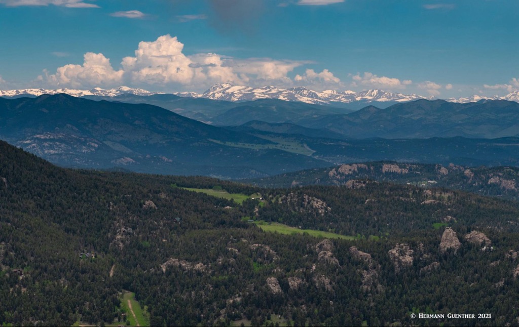
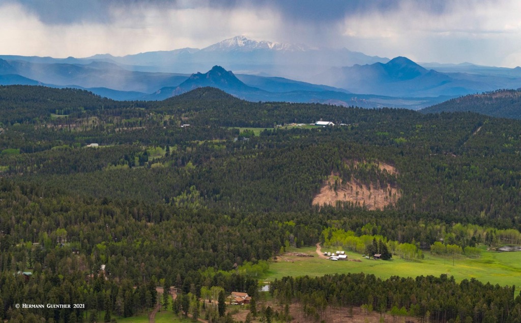
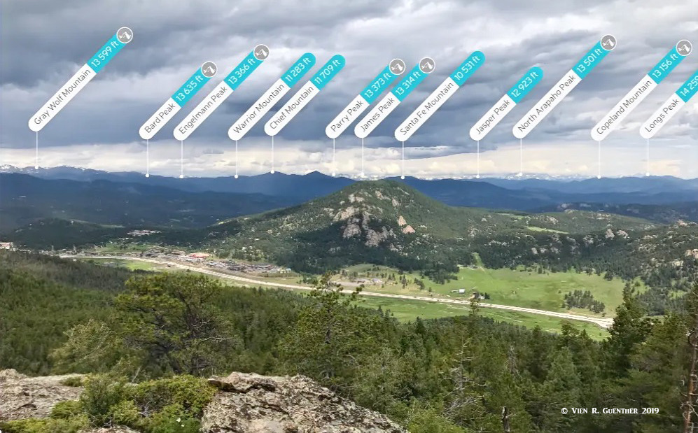
The views from the summit are epic. You will see four fourteeners from here, the most dominant ones being Pikes Peak in the south and Mount Evans due west, but Mount Bierstadt just behind Mount Evans and Longs Peak in Rocky Mountain National Park are also visible on clear days, which are frequent. Also easily seen from here is a 50-mile expanse of the high peaks of the Continental Divide to the west. The eastern view encompasses hundreds of square miles of the Great Plains just beyond the lower foothills just in front of you. Since the whole round-trip hike is only 6.5 miles, your reward for that minimal effort is far greater than that of those hikers who only stay on the official trails in this park.
Since we lived in the city of Lakewood about 16 miles from the trailhead, Meyer Ranch Park was only about 25 minutes away. Needless to say, we came to this park many times since it was so convenient. Its relatively high elevation makes this park a pleasant year-round hiking destination. This also means that almost the entire greater Denver area population has easy access to the park via good highways. Of course not everyone comes here – there are so many other fine hiking venues up and down the Front Range of Colorado.
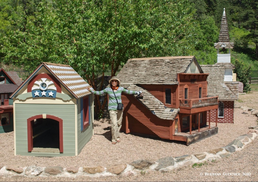
This semi-rural town deep in the foothills is right next door to Meyer Ranch Park, with its other attractions. The settlement of Aspen Park, part of Conifer, is less than two miles from the park’s trailhead and offers restaurants and a supermarket as well as other essential services. But the only accommodation in the area that I know of is one bed-and-breakfast inn less than a mile east of the park along U.S. Highway 285. Further to the east is a perennial must-see attraction if you have little kids to entertain (actually, adults also have fun there, as we did after one of our hikes in Meyer Ranch Park). This place is called Tiny Town (“world –famous” according to their marketing people) and it really is tiny. The many houses and buildings look like toys from a distance. But there is a miniature train that loops through the “town” and adults can also ride on it - a fun thing to do after your hike at Meyer Ranch Park if you are not exhausted from your hike – and you shouldn’t be, it was easy remember?