Scan the QR code and open PeakVisor on your phone
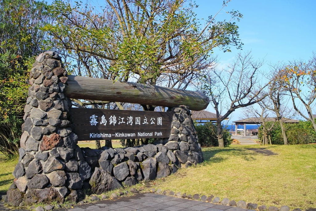
Kirishima-Kinkowan National Park is located by the southern bay of Kyushu in Japan, and it is the site of an immense complex of volcanoes, crater lakes, and hot springs, all of which work together to craft a unique landscape that is also rich in greenery and life. There are 28 named peaks in the park, the tallest and most prominent of which is Mount Karakuni at around 1,700 m (5,577 ft) in elevation.
Kirishima-Kinkowan National Park is centered around two main areas: Mount Kirishima (belonging to the Kyushu Mountains) and Kinkowan/Kagoshima Bay. Both of these topographical features are located on Japan’s southernmost major island of Kyushu. They are split between the Kagoshima Prefecture on Kyushu’s southwestern coast and the adjacent Miyazaki Prefecture, which is located along Kyushu’s eastern coast.
In the northern end of the park is the Kirishima area, which straddles the border between Kagoshima and Miyazaki. This section is dotted by a couple dozen volcanoes, volcanic crater lakes, hot springs, plateaus and lava plateaus, and other volcanic landforms.
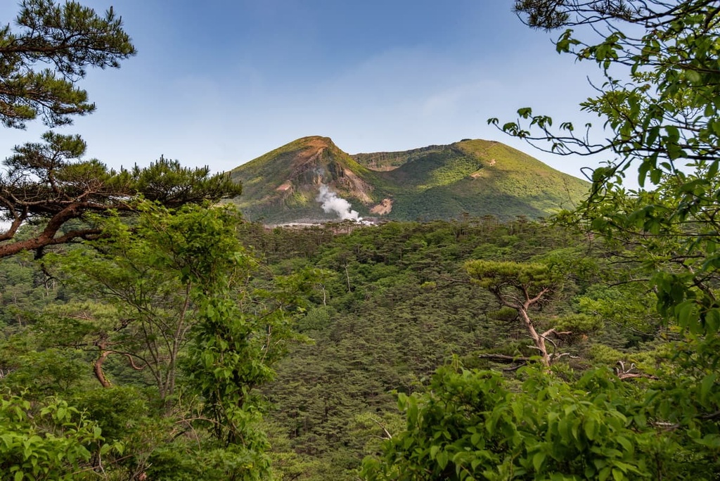
Mount Karakuni can be found in the northern part of the park with Onamiike Crater Lake at its feet. Lake Miike, too, is another crater lake of note. There are also numerous ponds that occupy the flat span of the Ebino Highland. In the southern part of the Kirishima area, there are a number of notable features such as https://peakvisor.com/peak/shinmoe-dake.html and Mount Takachiho-no-Mine, the latter of which is a location of great cultural importance in Japanese mythology.
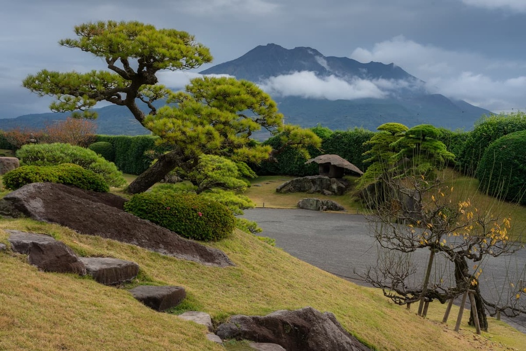
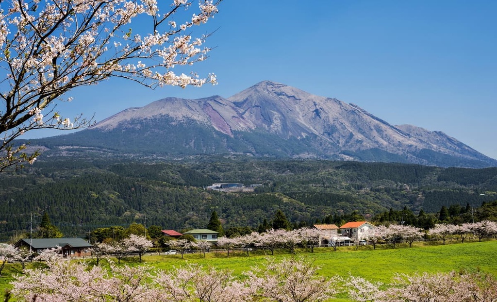
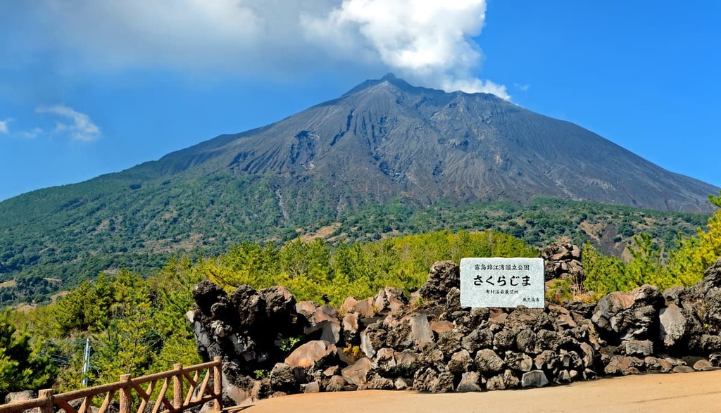
Meanwhile, the southern part of the park is located along the Kinkowan Bay. Here, the main features are Mount Sakurajima, the most active volcano in Japan, and the Aira Caldera. Sakurajima has three peaks at its summit: Kitadake, Nakadake, and Minamidake. Kitadake is its tallest point at 1,117 m (3,665 ft) above sea level.
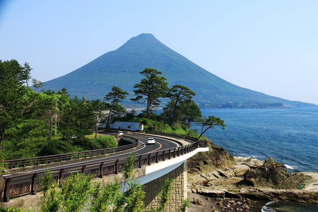
This part of the park is home to forests, fertile farmlands, pine-lined white sand beaches, caldera lakes like Lake Ikeda, and volcanoes like Mount Kaimon. There are also small islands like Chiringashima speckling the coast, which can be walked to via sandbar during low tide. Across the bay is Cape Sata, where rocky cliffs loom above the shore, and subtropical jungles color the land.
The Kirishima Mountains form an active cluster of andesitic late-Pleistocene-to-Holocene volcanoes on a basement of Cretaceous sedimentary rocks and Pleistocene volcanic rocks. Older mountains in the group tend to have compositions of mainly pyroxene andesite, while younger mountains have a mix of pyroxene andesite with olivine basalt and pyroxene dacite.
Some of the volcanoes in the eastern Kirishima Mountains, like Ohachi, Takachiho-no-Mine, and Hinamoridake are more basaltic and basalt andesitic in nature, while the western volcanoes contain mostly pyroxene andesite.
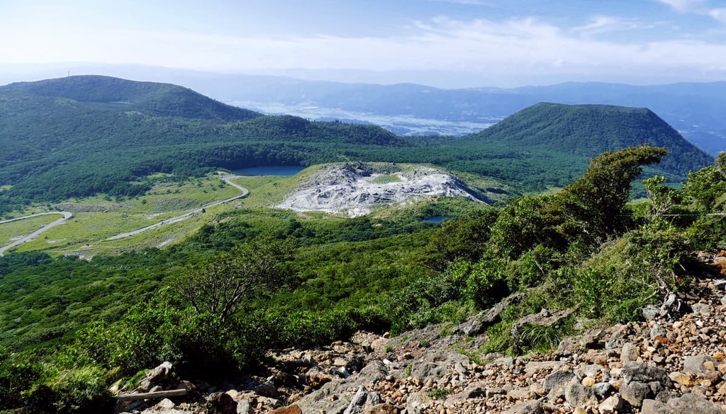
To the northwest along the slopes of Mount Karakuni are the flat lands of the Ebino Plateau, which rest upon a volcanic alluvial fan. This alluvial fan is in turn located near the sulfur dioxide–emitting Mount Io. Lake Miike formed several thousand years ago from a crater after a magma vapor eruption.
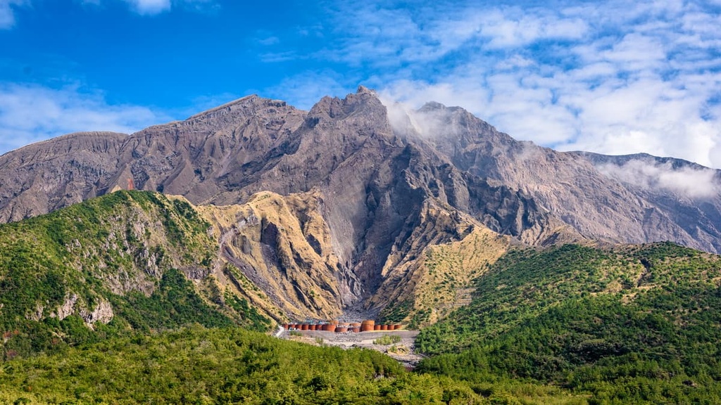
As for the southern portion of the park, the 25 km (15 mi) wide Aira Caldera formed over 22,000 years ago as the result of a sequence of pyroclastic surges. Located along its southern edge is Mount Sakurajima, which overlies a magmatic chamber (connected to the Kirishima magmatic system) that causes it to be so remarkably active. Volcanic activity in Aira eventually resulted in the formation of Sakurajima about 13,000 years ago.
Sakurajima was once a volcanic island before lava flow about a century ago connected Sakurajima with the Osumi Peninsula through a newfound strait. Kitadake, the older stratovolcano, contains pyroclastic rocks and interbedded lavas, while Minamidake, the younger volcano, consists heavily of lava.
Kirishima-Kinkowan National Park is located within the Taiheiyo evergreen forests ecoregion, a type of temperate broadleaf ecosystem. In the mountainous areas of the park, the plant communities vary based on elevation, with the highest elevations containing vegetation tailored to solfatara environments and vast spans of pink Kyushu azaleas.
In more mid-elevation regions, the park is characterized by broadleaf deciduous forests of beeches, evergreen forests of oaks, and temperate coniferous forests of firs. At low elevation areas, the ecosystem becomes more subtropical, with trees like the banyan. Some other notable trees in Kirishima include Japanese big leaf magnolias, ichiigashi oaks, Japanese red pines, Mongolian oaks, and hemlocks.
The Kirishima area also hosts a great variety of flowers that bloom throughout the year. These flowers include Japanese witch hazel in the spring; silky wisterias, Oyama magnolias, and Iwakagami in early summer; and yellow patrinias and Japanese felworts in the fall.
Around Kinkowan Bay, plants like the banyan and fern palm are more prominent. Meanwhile, Cape Sata-misaki hosts plants like the sacred garlic pear and Chinese fan palm.
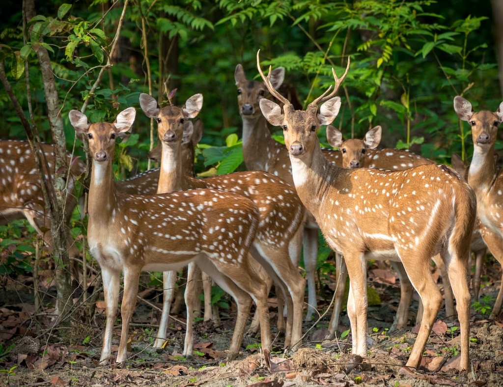
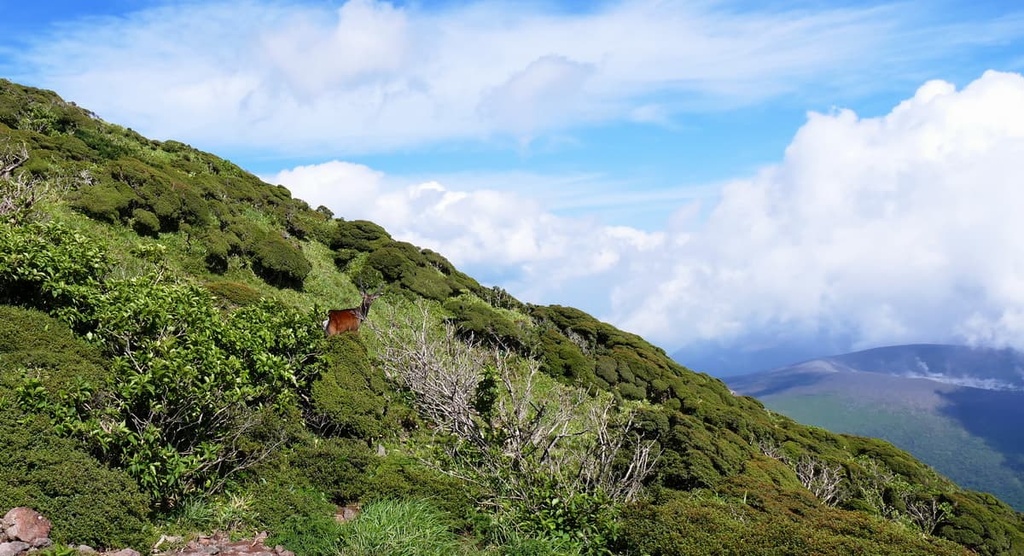
When it comes to fauna, Kirishima boasts a diverse population of birds, like the ruddy kingfisher and the pitta, as well as a growing population of Japanese deer. There are also notable insects like the hairstreak and butterflies found in the park.
The park’s Kinkowan Bay is home to birds like the brown booby and Japanese cormorant, as well as migratory butterfly species like the peacock pansy and great orange tip. Kinkowan Bay is also home to other creatures like rare dragonflies and giant mottled eels.
Indeed, the aquatic ecosystems of the park are likewise unique and impressive, with the bay containing colorful ecosystems of coral and seaweed and all sorts of subtropical fish, like the butterfly fish and heavenly damselfish.
Other creatures that can be found throughout the park include the wild boar, screech owl, Mandarin duck, Chinese goshawk, gray-faced buzzard, and black paradise flycatcher.
The area of Kirishima-Kinkowan National Park has long been of cultural and historic significance. Archeological sites of shelters, tombs, tools, and pottery have been found in both Miyazaki and Kagoshima prefectures, suggesting human settlement in the region began thousands of years ago, way back in the Paleolithic.
The park generally followed the historical paths of its two prefectures, from the societies of the Kofun period to the presence of the daimyos to the domination of the Satsuma han and the eventual abolition of the han under the rule of the Emperor Meiji.
The Satsuma han had been relevant for hundreds of years before the Edo Period and had their roots in the Shimazu family. At times, the han had ruled extremely large swaths of land that would become Kirishima-Kinkowan National Park, as for much of their centuries of existence, they were quite a wealthy and powerful authority.
The han were a domain under the Tokugawa shogunate from 1602 to 1871. When the han system was abolished, Satsuma’s authority was transferred to Tokyo instead.
Another interesting historical fact is that the park is believed to be the first “honeymoon” site in Japan, as it is where one of Japan’s most esteemed samurai, Ryoma Sakamoto, spent his honeymoon back in 1866.
Hikes are plentiful at Kirishima-Kinkowan National Park, whether they wind along crater lakes and volcanic peaks or verdant grasslands and scenic bays. One of the main attractions in the park is, of course, Mount Karakuni and its adjoining Onamiike Crater Lake, the highest crater lake in all of Japan.
The 9.7 km (6 mi) Mount Karakuni and Onamiike Crater Lake Hiking Trail departs from the Ebino Eco-museum Center. It then goes across the Ebino Plateau and up Karakuni, where nearby mountains Shinmoedake and Takachiho-no-Mine are visible. Finally, it makes its way down to the incredibly blue crater lake.
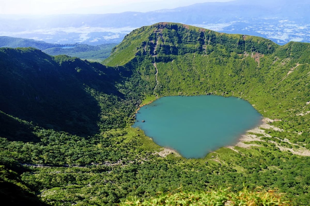
The medley of colors—the blue of the lake, green of the leaves, and the pink of the azaleas in the summer or the red of the forests in the autumn—and the majesty of the mountains make the hike all the more appealing.
From the Ebino Eco-museum Center, there is also the Mount Ebino and Koshikidake Hiking Trail, a 13.8 km (8.6 mi) hike up the Ebino and Koshikidake peaks and across the Ebino highland.
Mount Koshiki, too, is home to a beautiful crater. This crater also contains a small marsh that turns a rich green in the summer and a rich gold from fall to winter when the pampas grass grows. Atop Mount Ebino, you can even see Kinkowan Bay.
Alternatively, one could take the 9.9 km (6.2 mi) Abundant Shiratori Kyodo-no-Mori Forest Walking Trail from the Ebino Eco-museum Center. This trail takes you through primeval forests that contain over 600 giant trees and traditional hot springs alongside a gently-flowing stream.
Or there is the 8.7 km (5.4 mi) Ebino Highland Crater Lake Hiking Trail. This trail travels along the edges of three of the plateau’s crater lakes, each of which is magnificently beautiful throughout the year.
The 7.8 km (4.8 mi) Kurinodake and Hachiman Jigoku Trail loops from the trailhead at the Railway Tie Stairway and snakes through a primeval forest of maples and oaks that is said to be extraordinary in the fall.
It also goes up Kurinodake, which features views of the peaks of Karakuni and Shiratori. Here, you’ll come across Hachiman Jigoku, Kyushu’s largest fumarole, where volcanic steam and gas seem to eternally emanate.
As for Mount Takachihonomine, a 5.5 km (3.4 mi) trail from the Takachihogawara Visitor Center takes you up this mountain steeped in folkloric and historic significance as it is famous as the site of Japan’s “first honeymoon.”
The mountain is known as well for its steaming Ohachi crater, the bronze spear impaled into its peak, and the views of Lake Miike, Mount Sakurajima, the Hyuganada Sea, and the city of Miyakonojo that you can enjoy from the summit
From Takachihogawara, there is also the 2.6 km (1.6 mi) Takachihogawara Kyushu Azaleas - Miyama Kirishima Trail. This trail passes along a scenic path of Mount Nakadake Chuufuku, old-growth forests, ancient ruins of the Kirishima-jingu Shrine, and massive thickets of flowers that blossom in the spring and bring all sorts of color to the area.
For a more forest-focused trail, allowing for the best exploration of Kirishima’s plentiful and diverse avifauna, there is the 13.3 km (8.3 mi) Miike Wild Birds’ Forest Trail. This is a journey through dense broadleaf forest where birds love to nest, and where you can see a 160 year-old oak tree and the pristine Lake Miike up close.
There are also options for hiking Mount Sakurajima, such as the 14.5 km (9 mi) hike to the Yunohira Observation Point, which deposits you just 2.5 km (1.6 mi) from Sakurajima’s ever-smoking crater and offers a great view of its peak.
Alternatively, the 3 km (1.8 mi) Nagisa Lava Trail cuts through the lava field and shows off the strange and alien rock formations that make the peak’s landscape so unique.
Looking for a place to stay during your next trip to Kirishima-Kinkowan National Park? Here are some of the best nearby cities to check out during your adventure.
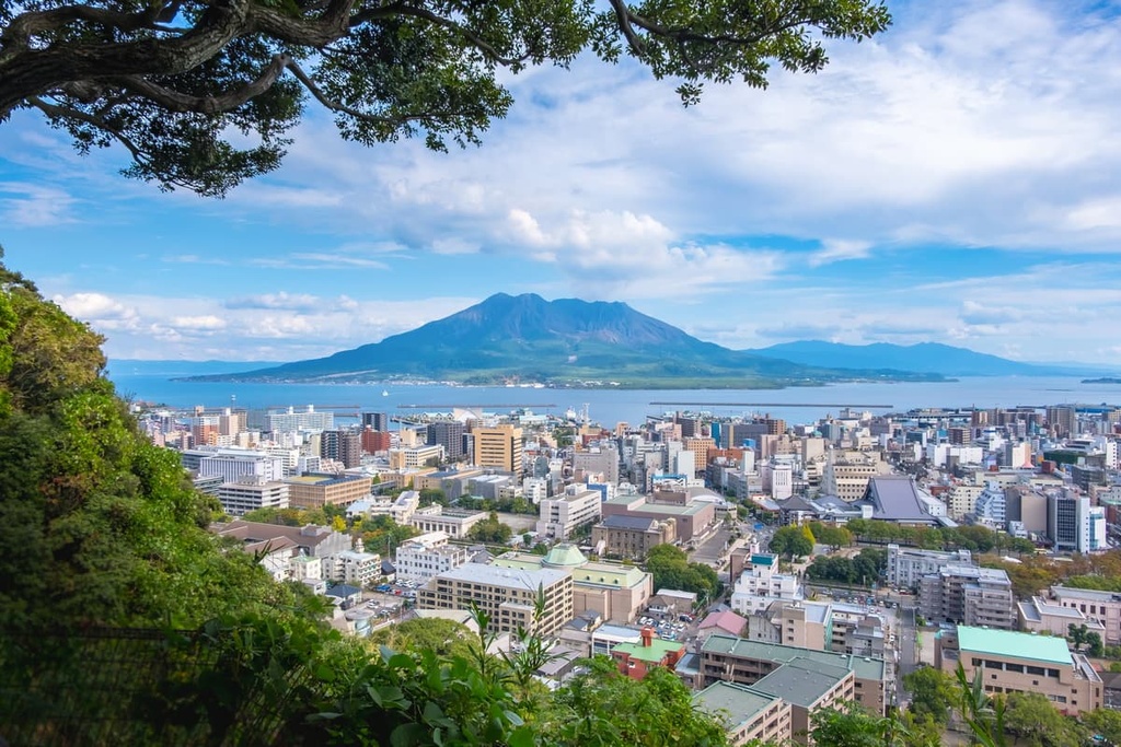
Kagoshima is the capital city of Kagoshima Prefecture and, by a sizable margin, the prefecture’s largest city at around 600,000 inhabitants. Its size, plentiful opportunities for recreation and nightlife, and its proximity to the park, make it a great base for anyone looking to explore Kirishima-Kinkowan and southern Kyushu.
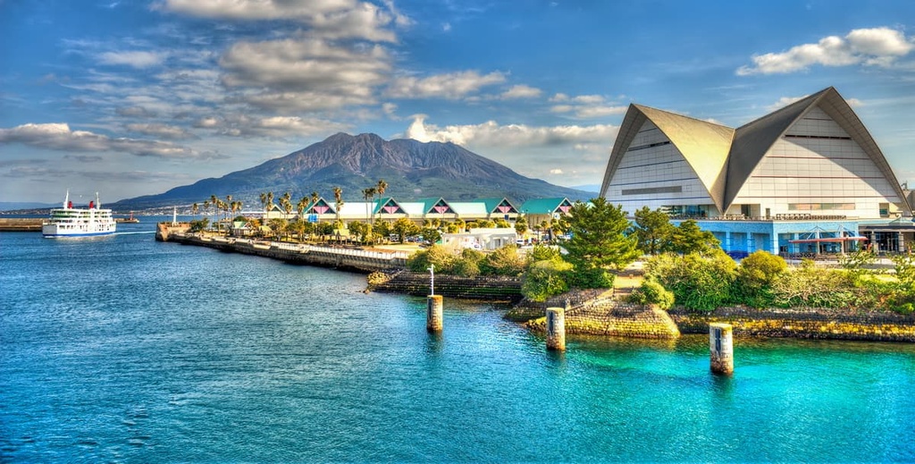
The city is called the Naples of Japan for its pretty streets lined with palm trees, warm climate, and nearby volcano, though it trades Vesuvius for the grand sight of Sakurajima.
The view of Sakurajima from the beautiful Sengan-en garden in the city is unparalleled; the old castle grounds around Terukuni-jinja shrine, stone bridges and greenery of Ishibashi Park, and history museums like Reimeikan and the Museum of the Meiji Restoration are other notable sights in the city.
The dining and nightlife scene in the city is best exemplified in Tenmonkan, a vibrant shopping and entertainment district full of boutiques, bars, and restaurants that serve local delicacies. And, of course, a visit to Kagoshima necessitates a trip to the waterfront parks and promenades of Kinkowan Bay.
Kagoshima is connected to the Kyushu Shinkansen and to the main railways of southern Kyushu, allowing for easy transport in and out of the city to the rest of the island. There are also ferries that travel across the bay and to the southern islands, and there is a domestic airport, Kagoshima AIrport, not too far from the city. There’s also a public tram system for getting around the city itself.
Located about an hour to the east of the park is the city of Miyazaki, the largest city in Miyazaki prefecture with around 400,000 inhabitants. Miyazaki is a great base for those looking to see more of the prefecture, as it is known as a resort spot with a gorgeous coastline, lots of recreation, and a rich history that comes to life in its many shrines, like Miyazaki-jingu, which is located right in city center, and the nearby cliffside Udo-jingu.
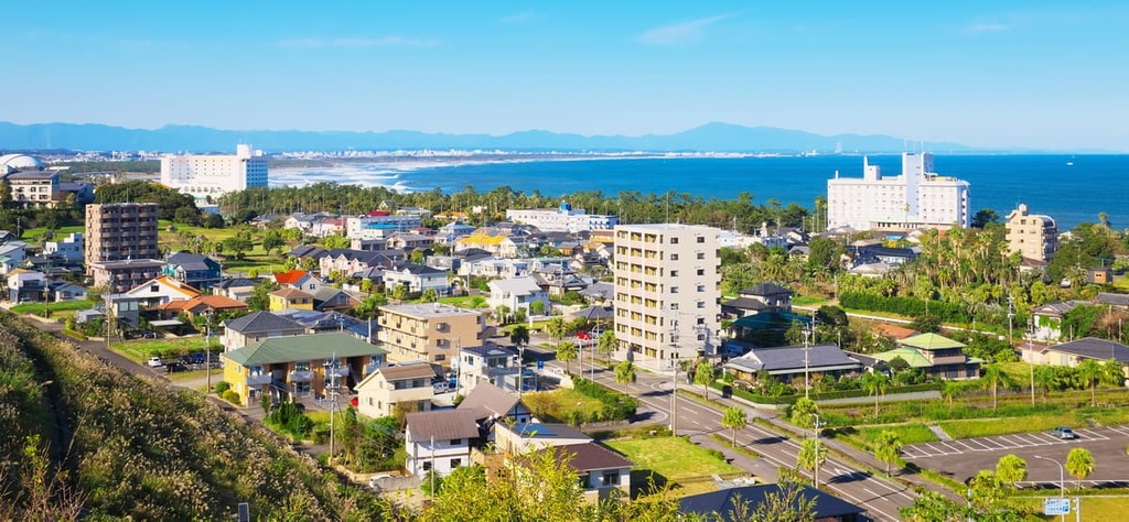
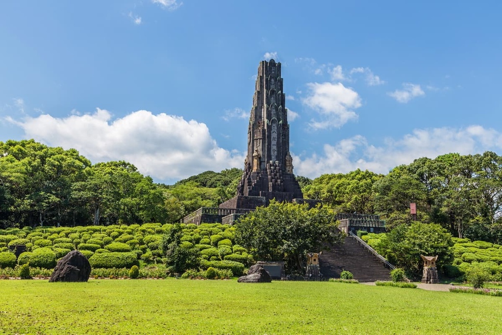
There is also the iconic Heiwadai Park where the stone Peace Tower, made in 1940, stands tall over the lush greenery below. And just off the coast of Miyazaki’s white beaches is Aoshima Island, which is connected by a bridge to the mainland and features both a colorful red shrine and subtropical forests.
Other sites in and around the city include the Miyazaki Prefectural Museum of Nature and History, the Miyazaki Science Center, Awagigahara Forest Park, and the vibrant Florante Miyazaki flower park. Golfing and surfing are popular activities in the city, as is seeing the zoo, or taking a trip to the Aya Shusen-no-mori brewery.
Miyazaki is served by Miyazaki Airport, which connects it to Honshu, South Korea, and Taiwan. The city is also home to the Nichinan Line of the Kyushu railway, which connects it to the rest of the island. In the city, one can also get around through local buses.