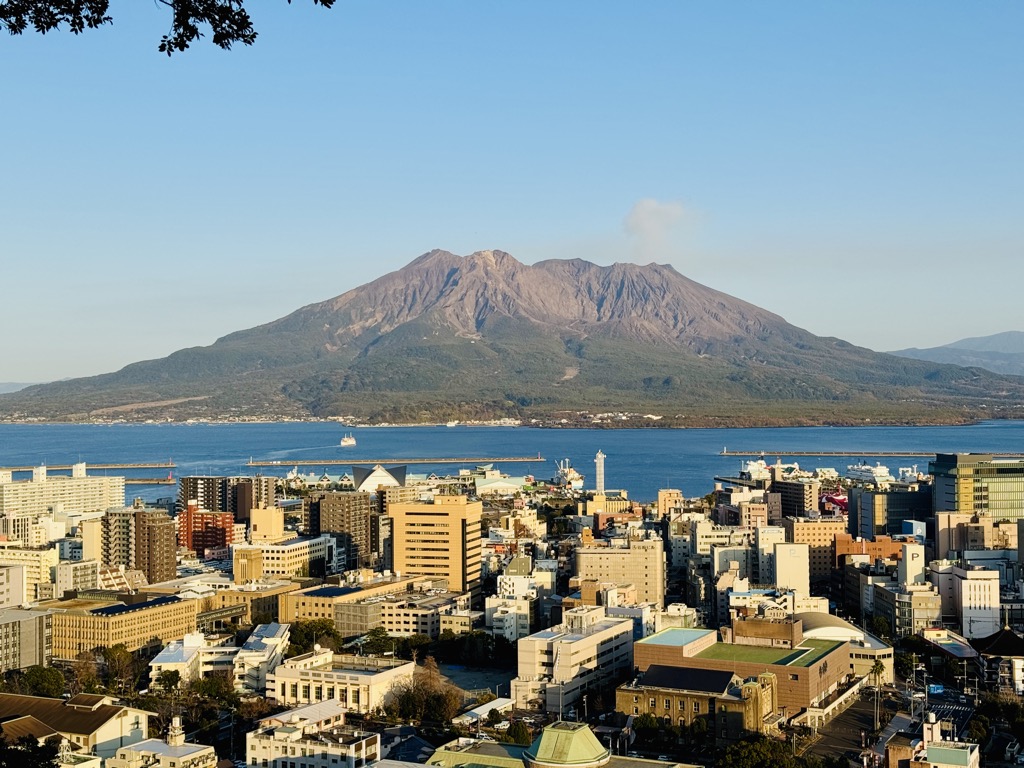
Sakurajima (Japanese: 桜島, lit. 'Cherry Blossom Island') is an active stratovolcano, formerly an island and now a peninsula, in Kagoshima Prefecture in Kyushu, Japan. The lava flows of the 1914 eruption connected it with the Ōsumi Peninsula. It is the most active volcano in Japan.
As of April 2021, the volcanic activity still continues, dropping volcanic ash on the surroundings. Earlier eruptions built the white sand highlands in the region. On September 13, 2016, a team of experts from Bristol University and the Sakurajima Volcano Research Centre in Japan suggested that the volcano could have a major eruption within 30 years; since then two eruptions have occurred.
Sakurajima is a stratovolcano. Its summit has three peaks, Kita-dake (northern peak), Naka-dake (central peak) and Minami-dake (southern peak) which is active now.
Kita-dake is Sakurajima's highest peak, rising to 1,117 m (3,665 ft) above sea level. The mountain is in a part of Kagoshima Bay known as Kinkō-wan. The former island is part of the city of Kagoshima which is only 4km across the bay. The surface of this volcanic peninsula is about 77 km2 (30 sq mi).
Sakurajima has a population of a few thousand residents, formerly incorporated as Sakurajima town, with a number of schools, shrines, and shops on the island. It is serviced by the Sakurajima Ferry which runs 24/7. It is a tourist destination known for its onsen, local pottery made from volcanic ash, and produce such as the Sakurajima daikon radish and Sakurajima komikan orange which grow in the immensely fertile volcanic soil.
Sakurajima has many natural areas and the ecosystems in different areas where recent eruptions have taken place have been researched as an example of ecological succession.
By elevation Sakurajima is
# 24 out of 271 in Kagoshima Prefecture # 2 out of 27 in Kirishima-Kinkowan National Park
By prominence Sakurajima is
# 14 out of 27 in Kirishima-Kinkowan National Park
We use GPS information embedded into the photo when it is available.
3D mountains overlay
Adjust mountain panorama to perfectly match your photos because recorded by camera photo position might be imprecise.
Move tool
Rotate tool
Zoom
More customization
Choose which peak labels should make into the final photo and what photo title should be.
Next
Photo Location
Satellitte
Flat map
Relief map
Latitude
Longitude
Altitude
OR
Latitude
°'''
Longitude
°'''
Apply
Register Peak
Peak Name
Latitude
Longitude
Altitude
Register
Teleport
PeakVisor
This 3D model of Sagarmatha National Park in Nepal was made using the PeakVisor app topographic data. The mobile app features higher precision models worldwide, more topographic details, and works offline. Download PeakVisor maps today.
Download OBJ model
PeakVisor
The download should start shortly. If you find it useful please consider supporting the PeakVisor app.
PeakVisor for iOS and Android
Be a superhero of outdoor navigation with state-of-the-art 3D maps and mountain identification in the palm of your hand!