Scan the QR code and open PeakVisor on your phone
Changhua County’s (彰化縣) relatively flat landscape consists of gently rolling hills and low-lying plains. Hengshan (橫山) is the tallest and most prominent of the 19 named peaks in Changhua County with an elevation of 447 meters (1,467 ft).
Situated in central Taiwan, Changhua County is an administrative region that borders Taichung City (臺中市) and Yunlin County (雲林縣). Nantou County (南投縣) is also located next to Changhua County while the Taiwan Strait is situated to the west.
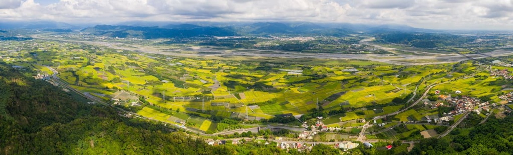
As it covers an area of just 107,440 ha (265,490 acres), Changhua County is Taiwan’s smallest region. Only 19 small peaks are located in Changhua’s entire territory. In fact, Changhua is one of the least mountainous areas of Taiwan.
Agriculture is the main industry in Changhua. Changhua’s Xihu Township (溪湖鎮) is actually Taiwan’s most prominent grape producer. Watermelon, guava, lychee, and starfruit are some of the other crops that are grown in this very productive part of the island.
Like its northern neighbor, Taichung City, Changhua isn’t as rainy as some of the other parts of Taiwan. The county as a whole receives only about 1,723 mm (68 in) of rain per year. This is due to the fact that the Central Mountain Range (中央山脈) shields Changhua to the east. For this reason, the typhoons that strike Taiwan’s eastern shores usually aren’t as destructive in the area around Changhua.
Rather, you can often find blue skies and sunny weather in Changhua County. Changhua experiences a humid subtropical climate and it has an annual average temperature of 72°F (22°C).
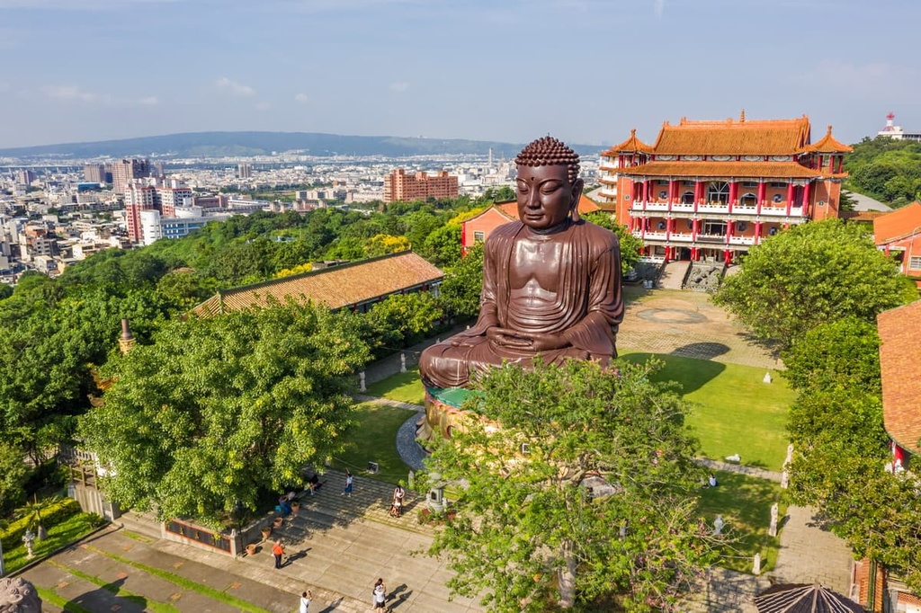
Changhua County is divided into two cities, six urban townships, and 18 rural townships. The region’s capital is Changhua City (彰化市), which is best known for the 24-meter (79-ft) tall Great Buddha Statue that’s perched on Baguashan (八卦山).
Changhua’s 19 hills are primarily centered around Baguashan. From the main peak of Baguashan, a narrow mountainous spine travels down Changhua County. These peaks rise gently in height as you move toward the south. They primarily consist of silt, slate, and sandstone from the Pleistocene.
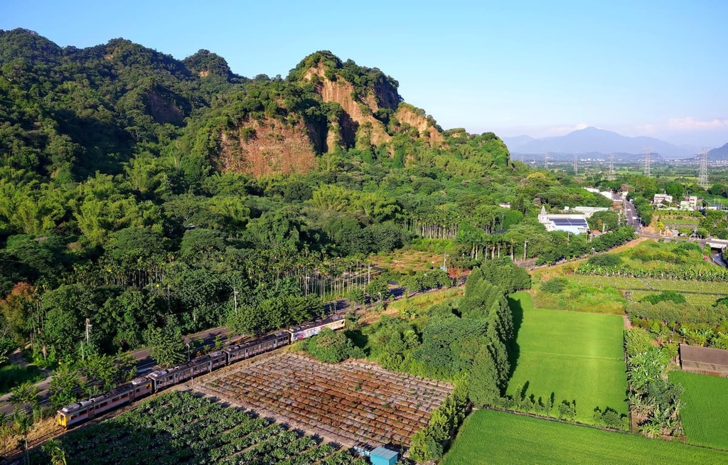
Changhua’s highest mountain, Hengshan, also boasts a 100-m (328-ft) tall cliff. This cliff formed as a result of the erosive effects of the Zhoushui River, which once flowed along the slopes of the mountain.
Two main rivers flow to the north and south of Changhua, and they serve as the borders between it and its neighboring counties. For example, the northern Dadu River separates Taichung City from Changhua. To the south, the Zhuoshui River serves as the boundary between Changhua and Yunlin County.
Changhua’s fertile land is home to a plethora of fruit-bearing plants and trees. In the spring and summer months, the country’s orchards burst with some of Taiwan’s highest-quality fruit. Vegetables and mushrooms are also grown in Changhua’s fields.
Other plants that you can find in the county include tung blossoms, jasmine, cosmos, and sunflowers. Near the Baguashan, you can also find some gorgeous woodlands that include acacia, moon peach, tung, and banyan trees.
Some of the earliest inhabitants of what is now Changhua were the ancestors of the contemporary Babuza tribe. The region itself is home to a number of archeological sites, including a few dozen burial sites that date back around 5,000 years.
The late 1600s brought a mass influx of Han Chinese settlers to Taiwan’s shores. These settlers dispersed along Taiwan’s northern and western coasts in an area known as Zhuluo County.
The northern part of Zhuluo County, which is now modern-day Taipei, subsequently increased in population as a result of this influx of settlers. In response, the Qing dynasty established Changhua County as a separate region from Zhuluo. Its jurisdiction covered modern-day Changhua County, half of Taichung City, Yunlin County, and part of Nantou County.
Once the Qing dynasty formed Changhua County, they chose Changhua City as its capital. Some of the landmarks that were built in the area during the Qing dynasty still stand strong to this day, such as the Longtan Temple and the Changhua Confucian Temple.
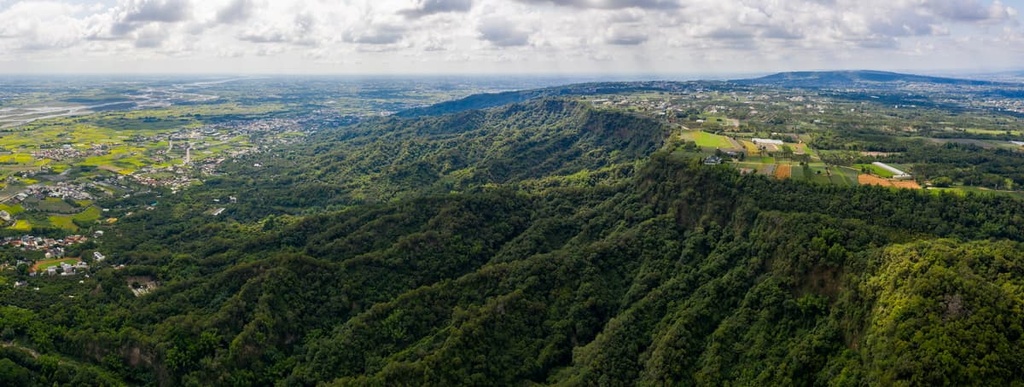
Although Changhua is known for its fertile flatlands, there are many hiking trails that lead through the Bagua Hills. Here’s a look at some of the best hikes in Changhua County.
Looking for good views? The Baguashan Giant Buddha just might be what you need.
As Changhua's most recognized and beloved landmark, the Baguashan Giant Buddha does not disappoint. This 24-m (79-ft) tall bronze Buddha statue is located at the summit of Baguashan and it overlooks the plains of Changhua.
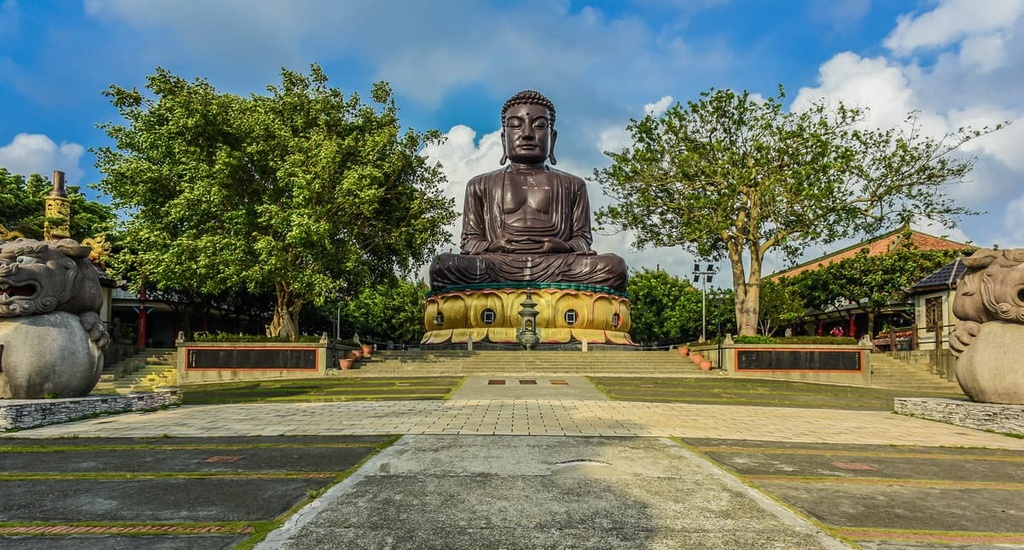
Visitors have the opportunity to climb up a series of steep stairs to ascent the six-story-tall Buddha and get better views. However, climbing to the top of the Buddha is strenuous and it’s not recommended for everyone.
Once at the top, visitors can gaze out at Changhua's city center and its flatlands. The Buddha is a particularly popular place to visit at sunset as it offers impressive views of the region.
Delve into the thicket below the Baguashan Giant Buddha for a stroll in nature on the Taoyuanli Forest Trail. This leafy 3 km (1.8 mi) path traverses the Huanxi Ecological Garden, which is home to more than 900 different plant species.
While on this trail, you can survey the forest canopy from a roped suspension bridge. But while the serenity of the forest can almost trick you into thinking that you’re in the middle of Taiwan’s remote countryside on this trail, the noisy city streets of Changhua are actually just a short distance away.
Nevertheless, in the Huanxi Ecological Garden, you can hear plenty of birdlife and, if you’re lucky, you might even spot some eagles and butterflies. Better yet, spring and summertime visitors can also see the garden’s incredible floral blooms and its many starfruit- and lychee-bearing trees.
The Hengshan Hiking Trail offers an opportunity for visitors to climb Changhua’s highest point, Hengshan. This area is also a particularly good place to try to spot the grey-faced buzzard during the spring months.
In fact, Hengshan is a birdwatcher's paradise. Around the peak, you can spot the crested goshawk, the sparrowhawk, and many other bird species as they soar through the sky.
The trail itself travels over undulating terrain as it makes its way toward Hengshan. Along the way, the trail offers potential views of Baguashan as well as some of the other landmarks in the region, such as the 100-m (328-ft) high Hengshan Cliff.
On a clear day, you can even see the Taiwan High-Speed Rail shooting across Changhua's grasslands below the mountain. If you get lucky, you might even see Yushan (玉山) in the distance from the summit of Hengshan.
The Tengshan Trail is a recent addition to the trail network of the Bagua Hills. This path is now paved, too, which makes it more accessible to a wider range of hikers. There’s even a weekend market along the trail where you can shop for snacks and admire the view.
Along the trail, wooden signposts featuring Taiwanese proverbs add opportunities for reflection as you walk. Plus, the Tengshan Trail boasts unrivaled views over the Changhua basin and the Taiwan Strait. On clear days, you can see the Baguashan Giant Buddha from the trail, too.
Set in the Qingshuiyan Forest Recreation Area (清水岩森林遊樂區), the Zhongyangling Trail is a 2.2 km (1.3 mi) long path that takes you through lush groves of acacia and chestnut trees.
While the trail itself is short, however, it is actually quite challenging due to its steep terrain. In fact, the last section of this hike involves a very steep climb, so it’s not appropriate for first-time hikers or anyone who’s uncomfortable with heights and exposure. For those who make it to the summit, however, rewarding views await.
The last section of this hike brings you up a wooden staircase to a scenic overlook. Here, you can revel in some incredible views of Changhua’s farmlands and Nantou's rural townships. The mix of white clouds, blue sky, and green fields that you can appreciate during a sunny day on this trail is truly a wonder to behold.
The Qingshuiyan Eighteen Bend Trail (also known as the Ancient Salt Picking Trail) is an overgrown path that follows the route that Changhua’s salt merchants use to take to trade with other merchants in nearby Nantou. The trail got its current name from its many sharp and sudden turns, which also make it popular among hikers.
There are a number of great aspects of this trail, including its plethora of shade. As the path wanders through a dense forest for most of its route, it offers some reprieve from the sun. Furthermore, this hike takes you through pineapple and tea plantations where you can also get views of some of the surrounding peaks.
The trail’s endpoint is the Mingjian Township (名間鄉) of Nantou County. While on this route, it’s possible to see as far away as Qilaishan (奇萊山), Hehuan Shan (合欢山), and Yushan on sunny days, too.
Taiwan’s smallest county is quite compact, so most of its major cities and towns are located relatively close to the region’s most popular tourist attractions. Here’s a quick look at some of the best places to stay in the region.
The first stop for most visitors arriving in Changhua County is the beautiful Changhua City, which offers a happy medium between urban and rural living.
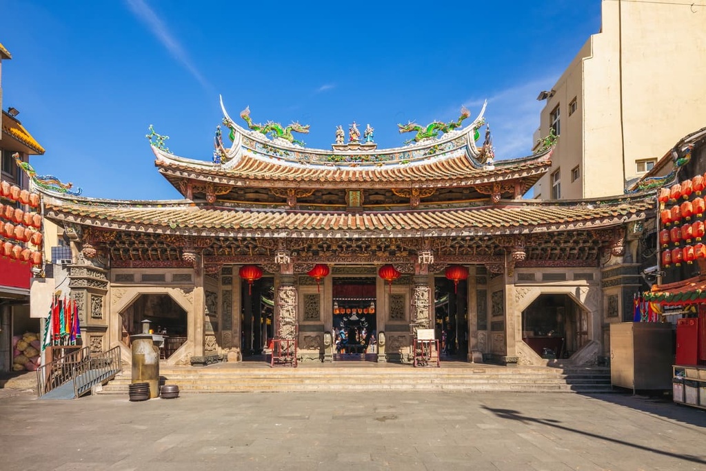
Changhua City is home to around 235,000 people, so it’s not as large as some of Taiwan’s best-known metropolises. Indeed, you can find solitude somewhat easily within the city, especially if you pay a visit to places like the Confucius Temple (彰化孔子廟). As it was constructed in 1726, this place of reverence is one of Taiwan's oldest temples. It features architecture that’s typical of the Qing dynasty, so it’s a true wonder to behold.

Alternatively, when night falls and you feel like taking a wander, consider heading to the Jingcheng Night Market (精誠夜市). The market is located just a short walk from the train station and it offers a plethora of local delicacies for visitors and residents to enjoy, such as hot plate steak, oyster omelets, and fried chicken skewers. For dessert, you can also find local dishes like papaya milk, mochi, and sugar-roasted chestnuts.
Finally, no visit to Changhua City is complete without a trip to the Changhua Roundhouse (彰化扇形車庫) where you can view a range of outdated and historic trains. Changhua's rail network is one of Taiwan's oldest as this central Taiwanese city was established in the 1700s. At the roundhouse, you’ll find a circular building that’s home to a number of historic rail carriages and locomotives where you can learn more about the history of trains on the island.
The seaside Lukang Township was formally established during the Qing dynasty when it served as an important trading port. To this day, the township continues to be an economic hub for the county, though it still manages to retain its historic and picturesque charm.
Lukang Old Street (鹿港老街) features a well-preserved historical village that boasts narrow red-tiled streets, tiny alleyways, old storefronts, and many locally-owned businesses. The town retains many of its historic buildings from when it was a major trading port, so it’s a great place to check out if you want to learn more about eighteenth-century Taiwan.
While in Lukang, you can also marvel at the over 6,000 artifacts from the Ming and Qing dynasties that are showcased at the Lukang Folk Arts Museum (鹿港民俗文物館). The gallery features a collection of photos, furniture, embroidery, and musical instruments. The building’s red brick and stucco exterior also create the perfect blend of Asian and Western architecture for visitors to enjoy.
Alternatively, you could head to the Tianhou Temple (鹿港天后宮), which features an intricately carved wooden courtyard. Many marine and ocean motifs are present throughout the temple, and its centerpiece is easily its Goddess of the Sea statue. The temple is so well-known for its elegant design that it actually sees more than 1 million visitors each year.
Once you get to Taiwan, you can get to Changhua County by taking either the Taiwan High-Speed Rail (HSR) or local express train (TRA) to Changhua City.
Or, if you don’t want to take the train all the way to Changhua, it’s possible to take the train to Taichung City. From there, you can rent a car or scooter and make the 23 km (14 mi) journey by road to Changhua City.