
Scan the QR code and open PeakVisor on your phone
Canary Islands is home to 2,483 named mountains. The highest is Pico del Teide at 3,715 m.
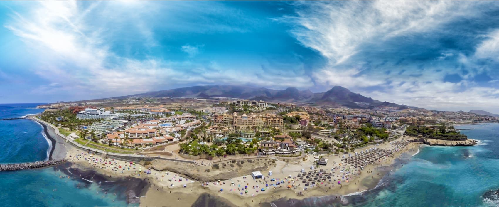
The Canary Islands are the southernmost territory of Spain and are located in the Atlantic Ocean, off the African coast. It’s a very mountainous archipelago of volcanic origin whose main islands are Lanzarote, Fuerteventura, Gran Canaria, Tenerife, La Gomera, La Palma, and El Hierro, with the recent addition of La Graciosa. El Teide volcano is located in Tenerife. It is the highest peak in Spain even though its height varies within a 3-meter window from 3,715 to 3,718 m a.s.l. depending on different research data.
The Canary Islands began to form about 30 million years ago in the Tertiary era. They are located on the African plate, in the area between the oceanic and continental lithosphere. The compression of materials between the two plates caused a series of faults through which magma ascended, which gave rise to each of the islands. The result is a volcanic relief, which rises several thousand meters from the seabed to the surface.
The Canary Islands are still experiencing some volcanic activity. In the recorded history, there have been 18 massive eruptions, the most recent is that of Teneguia volcano in 1971. These eruptions, in addition to transforming the relief, alter the coastline when lava reaches the sea. The scarcity of soil and the presence of bare rock on the ground surface is another characteristic of the Canarian terrain.
Mount Teide (7,500) is the highest peak in Spain. It’s located on the island of Tenerife. It’s also the highest point on the land in the middle of the Atlantic Ocean and the fourth highest volcano if measured from its base in the oceanic crust, the other three being Mauna Kea (10,203m), Mauna Loa (9,170m), and Haleakalā (9,144m) all located in Hawaii.

Considered one of the biggest attractions in Spain, Teide is located within the Teide National Park which has been declared a World Heritage Site by UNESCO. The Guanche aborigines, natives of the region, called it Echeide or Echeyde and it was a sacred mountain for them.
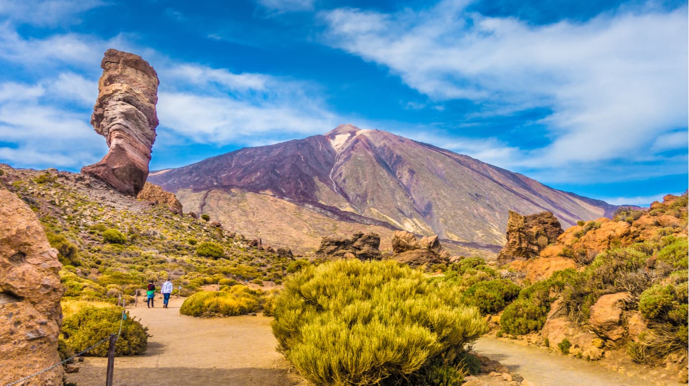
Like many of the world's best-known volcanoes,Teide is a composite volcano or a stratovolcano, formed over millions of years by the accumulation of successive layers of lava flows with different, mostly solid materials. Its entire structure is located within Las Cañadas, a volcanic caldera that measures 12 to 20 kilometres in diameter. It’s about 3,715 meters above sea level and registers a height of 7,500 meters above the ocean floor.
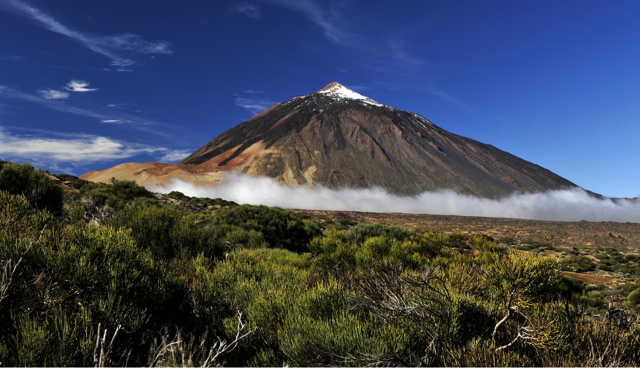
Together with Pico Viejo volcano, El Teide forms a single stratovolcano, which is called the Pico Viejo-Teide volcanic complex. Both structures emerged from the same magma chamber although they are usually described separately. Mount Teide is considered to be an active volcano even though its last eruption dates back to 1909. In winter, the snow lies on the summit and offers an attractive landscape for the millions of visitors of the National Park.
Tenerife is an island of volcanic origin that emerged from the ocean, so it’s not surprising that its relief features mountains and volcanoes. During the Miocene-early-Pliocene period, 3 shield volcanoes first appeared, which are the Teno, Adeje and Anaga mountain massifs constituting most of the land that is now Tenerife. In the second and the third stages, the three massifs stopped erupting and a new period of volcanic activity began after which other structures were formed.
The central volcano of the caldera was formed in the third stage and evolved throughout the Miocene. Las Cañadas caldera could have been the result of a massive landslide, large successive explosive eruptions, or a combination of both factors which occurred 160,000-220,00 years ago when the central caldera volcano collapsed. Later, Las Cañadas II stratovolcano was formed, and after its collapse another stratovolcano emerged, Las Cañadas III. The Teide-Pico Viejo complex was formed during the Pleistocene period.
The last eruption of Mount Teide happened in 1909 and lasted 10 days.
According to the Smithsonian Institution's Global Volcanism Program, 42 eruptions have been confirmed, while 3 remain unconfirmed. The Pico del Teide and its vents have released a lot of pyroclastic material since its formation but the first observed eruption was in 1492, before that the island of Tenerife is considered to have been uninhabited for a long time. The last eruption at the summit occurred around 850 B.C.
Fortunately, no people live very close to it, so its danger is not as high as that of Vesuvius, Merapi or Popocatepetl, for example. However, there are more than 766,000 people about 100 kilometres away.
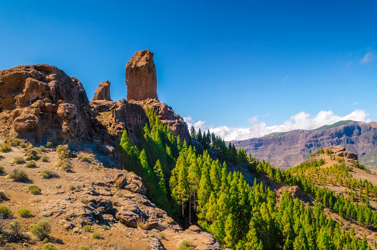
At almost 2,000 meters high, Pico de las Nieves, also known as Pozo de las Nieves (Las Nieve’s Well) is an exceptional viewpoint of the island of Gran Canaria. The highest summit of the province of Las Palmas de Gran Canaria is located in the heart of this Canary Island which can be reached by various ways that allow stops at some of its landmarks.
Occupied by some military facilities, the foot of Pico de las Nieves (1,949 m) is accessible by car, so the best option is to organize your route that would take you to the centre of the island.

In front of the summit, just a few meters away, we can find Morron de la Agujereada (1,965m) which some maps and measurements place above Pico de las Nieves. To reach its top by the most feasible route, you have to access it by a very difficult path.
The easiest way to reach Pico de las Nieves is on the paved road that ends at a viewpoint. The geodesic vertex is a few meters above and is easily accessible.
It’s a very visited tourist place because there are impressive panoramic views over part of the island from its summit. On clear days, you can see the island of Tenerife crowned with its most prominent icon, El Teide.
Occupying the upper part of the peak, there are the facilities of the Aerial Surveillance Squadron No. 21 which is responsible for supplying radar data and radio communications to the Control Centre designated by the Combat Air Command to enable it to identify, control and conduct the aircrafts and enable commands. It has the secondary mission of transmitting data to the Canary Islands Air Control Centre (ACC).
The summit is located in the geographical centre of the island, within the limits of the towns of Tejeda, San Mateo and San Bartolomé de Tirajana. Pico de las Nieves is found within different protected natural areas such as the Paisaje Protegido de las Cumbres, the Monumento Natural del Risco and the Rural Park of Roque Nublo.
In this environment, you can find landscapes dominated by Canarian pine. There are awesome viewpoints and if there is good weather, you can see Roque Nublo, Roque Bentaiga and Mount Teide in the background.
The composite materials of Pico de las Nieves are approximately 3 million years old. It belongs to the agglomeration of volcanic series 2. The peak is the product of a collapse of an ancient stratovolcano.
Pico de las Nieves is covered by Canarian pines that were planted in the 1950s. Around the volcano, there are also rocky areas covered with yellow gorse and white sage.

The peak is topped by Morro de la Agujereada which can only be accessed in one part since the rest is guarded by the Spanish Armed Forces. From here, you can enjoy views of the southern part of the peak.
Pico de las Nieves is much more than the highest point on the island. It’s an important enclave to enjoy the multiple hiking routes that start or finish at the place. If you like hiking, the peak has a number of trails for you to get to know this area.
It’s also a must-see area for cycling lovers. The mythical climb to the snow peak, on the southern slope, is one of the most famous and hardest in the world of cycling. The ride, however, is spectacular and offers wonderful views.
La Palma is a small-sized yet great paradise for hikers. There are almost 1,000 km of trails, an island that is a UNESCO World Biosphere Reserve, landscapes that range from Roque de los Muchachos peak (2,400m) to the sea/ You will be passing through volcanoes calderas, thick Canary pine woods, laurel forests, groves of dragon and banana trees, lavish vineyards... and all on an island of just 700 sq.km.

Roque de los Muchachos is an area of unique natural and archaeological value. Its peaks whose heights reach approximately 2000m give the island of La Palma one of the deepest and most beautiful depressions of the Canary Archipelago crowned by El Roque de los Muchachos (2426 m), the highest summit of the island and the second in the Canary Islands after Mount Teide, Tenerife.
Located in the town of Villa de Garafia, it borders Caldera de Taburiente in its northern area. The altitude determines special climatic conditions with a marked annual thermal amplitude. Its flora and fauna are very specific and typical of the high mountains. Here are found many interesting endemics such as violeta de La Palma (Viola palmensis) or the Tajinaste azul (Echium gentianoides). While hiking in the vicinity of Roque, pay attention to several rock engraving stations. They represent the characteristic spiral, semi-circular or concentric motifs. However, it is the clear sky that wins most plaudits for being virtually void of light pollution. This is where the Astrophysical Observatory of Roque de Los Muchachos (ORM) is located at an altitude of 2,420 metres in the municipality of Garafia. It enjoys one of the most complete telescope arrays in the world. Thanks to its dark clear skies almost all year round, La Palma has become one of the most privileged locations on the planet for astronomical observation.
El Alto de Garajonay is part of the National Park de Garajonay and the highest point of the island of La Gomera. It arose during the second volcanic cycle of formation of La Gomera between 5 to 2 million years ago. It is formed mainly by basaltic and trachibasaltic flows.

On clear days, you can see the entire La Gomera almost completely from here. You can also see the islands of La Palma, El Hierro, Tenerife and even Gran Canaria if the day is very clear. Perhaps due to its strategic location, this place has been surrounded with a magical halo since ancient times. This is demonstrated by the remains of sacrificial sails of pre-Hispanic origin found throughout the area.
Alto de Garajonay is also a natural watchtower for sky observation. It is easily accessible by car and has a small parking area. Being 1,487 m high, this place is one of the best locations to observe La Gomera’s roof of heaven due to its privileged location and the low incidence of light pollution.

El Hierro, located in the southwestern tip of the Canary Islands, was the smallest of the seven islands until recent years when La Graciosa was officially appointed as the 8th island of the archipelago, with just 275 sq.km., which makes it the least exploited. Its rugged geography offers a great landscape diversity with lajiales (badlands) and arid volcanic formations in the south and west, fertile land cultivated in the El Golfo platform, humid laurel forests and dense pine forests in the central zone, and ravines with rocky cliffs boasting striking erosive patterns along the entire coast. 60% of the island's surface is protected and since 2000, El Hierro has been declared a World Biosphere Reserve.
The highest point of El Hierro is Malpaso or Tinganar peak (1,501 m) located on the edge of the line of peaks that delimit the arch of El Golfo, the most characteristic geomorphological phenomenon on the island. Its origin is associated with the excessive growth of a central volcano formed in successive stacks and eruptions which had managed to build up a mount around 2,000 m in height. Due to the instability of the complex, a gigantic gravitational slide occurred that cut the summit, dragging more than 300 cubic km. of land onto the ocean floor and leaving an impressive natural amphitheatre with high walls of 1,200 m. The distance between the insular roof (1,501 m) and the closest coastal point is just 3.5 km in a straight line, which gives us an idea of the great steepness of some of its slopes. In line with the latter and as a curiosity, El Hierro is one of the islands with the highest height (m) per area (sq.km.) ratio in the world.

In El Hierro, there is a wide network of marked trails. Many of them are based on traditional paths that were used in the mudás (temporary change of residence). Through them, the islanders moved seasonally, according to the agricultural tasks at hand or the use of pastures for livestock. They were also used to trade harvest produce, fish, or other merchandise.
You can ascend to Malpaso from almost any point on the island using any of these paths or combining several of them, on more or less long itineraries depending on your desire to walk or the transportation availability. The trail map is available at the tourist offices and can also be downloaded from the Cabildo de El Hierro website.
At the foot of the Atlantic, from the extensive and kilometre-long golden beaches of Jandia, high rocky ridges rise. These are the peaks of the Jandia, the most abrupt and high mountain system of Fuerteventura. Hidden under thick clouds, rises Pico de La Zarza, the highest point and roof of the island with its 817 meters of altitude. The Jandia peaks split the Punta de Jandia in two, a colossal dividing line of several kilometres of rock that gives rise to two great valleys, the Cofete to the west and the Sotavento to the east.
This privileged situation is not only a guarantee of one of the best views on the island but also a perfect condition for unique environments and places that are in great contrast with the rest of the Canary Island landscapes.
You’ll enjoy hiking there. In a little over 2.5 hours, you can see such staggering environments as the Saladar del Matorral on the coast, the wettest areas of the entire island. The most impressive part of the entire hike are the spectacular views over the east coast of the Jandía Natural Park, the only area of Fuerteventura that remains within the trade winds regime.

The moisture-laden air currents collide slightly with the heights of the mountain creating a peculiar ecosystem marked by the contributions of humidity that forms the clouds that are much higher than those of the rest of the island. From the top of Pico de La Zarza, you can see the spectacular west coast of the island, with the Cofete beach as its greatest exponent, one of the last remaining virgin ones in Spain.
The so-called Peñas del Chache (670m) has become the highest point on the island of Lanzarote. It can be said that it’s the top of the Famara massif, which if seen from it the area of El Jable and Famara beach, looks like a formidable wall and is called La Montaña although it is not properly a mountain in the particular sense that this term has in Lanzarote and the rest of the archipelago but rather a rocky hill.
Due to its height and because it’s located on a cliff, Peñas del Chache served in the first centuries after the conquest as a watchtower from which people spotted the approach of suspicious ships along the north and west coasts. Today, Peñas del Chache can be seen from afar not because of what they are, but due to two huge spheres that were placed for the aviation control system.

The name of Chache is of undoubted Guanche (Canarian aborigines) origin, although we know nothing of the meaning it may have had in the language of the first inhabitants of the island, it could be related to other Lanzarote names with close phonetics, such as Ajache, Tinache and Tinaguache and very possibly also with the anthroponym Ache, who was the brother of the last king of Majos Guardafria.
La Graciosa is one of the authentic havens of peace and tranquillity that remain in Europe. With about 30 sq.km, and just over 700 inhabitants, it’s an idyllic corner to get lost in the world. The eighth inhabited island of the Canary Islands is a paradise for relaxation, the perfect getaway to escape from routine. It has the (almost) last virgin beaches on the planet, heart-stopping landscapes. It is a perfect embodiment of bygone days when humans were so scarce.
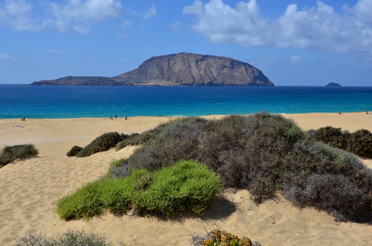
Agujas Grandes or Pico La Agujas (266m) is the highest peak, it has a volcanic origin and dominates the terrain of the island. The Megalodon, the world's largest extinct shark, used to live in its waters, it was a fearsome predator that could grow 20 meters long and weigh more than 100 tons. Along with the islets of Alegranza, Montaña Clara, Roque del Este, Roque del Infierno, Riscos de Famara and the Corona volcano, and Malpaís, La Graciosa is part of the Chinijo Archipelago Natural Park where seabirds have their breeding colonies.


Yes. Canary Islands has 2,483 named mountains. The highest is Pico del Teide at 3,715 m.
The highest mountain in Canary Islands is Pico del Teide, at 3,715 m.
Canary Islands has 2,483 named mountains.


