
Scan the QR code and open PeakVisor on your phone
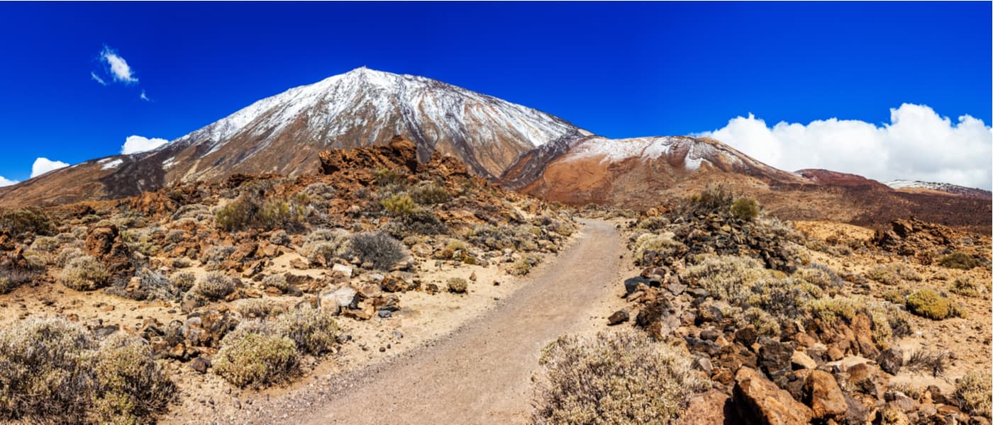
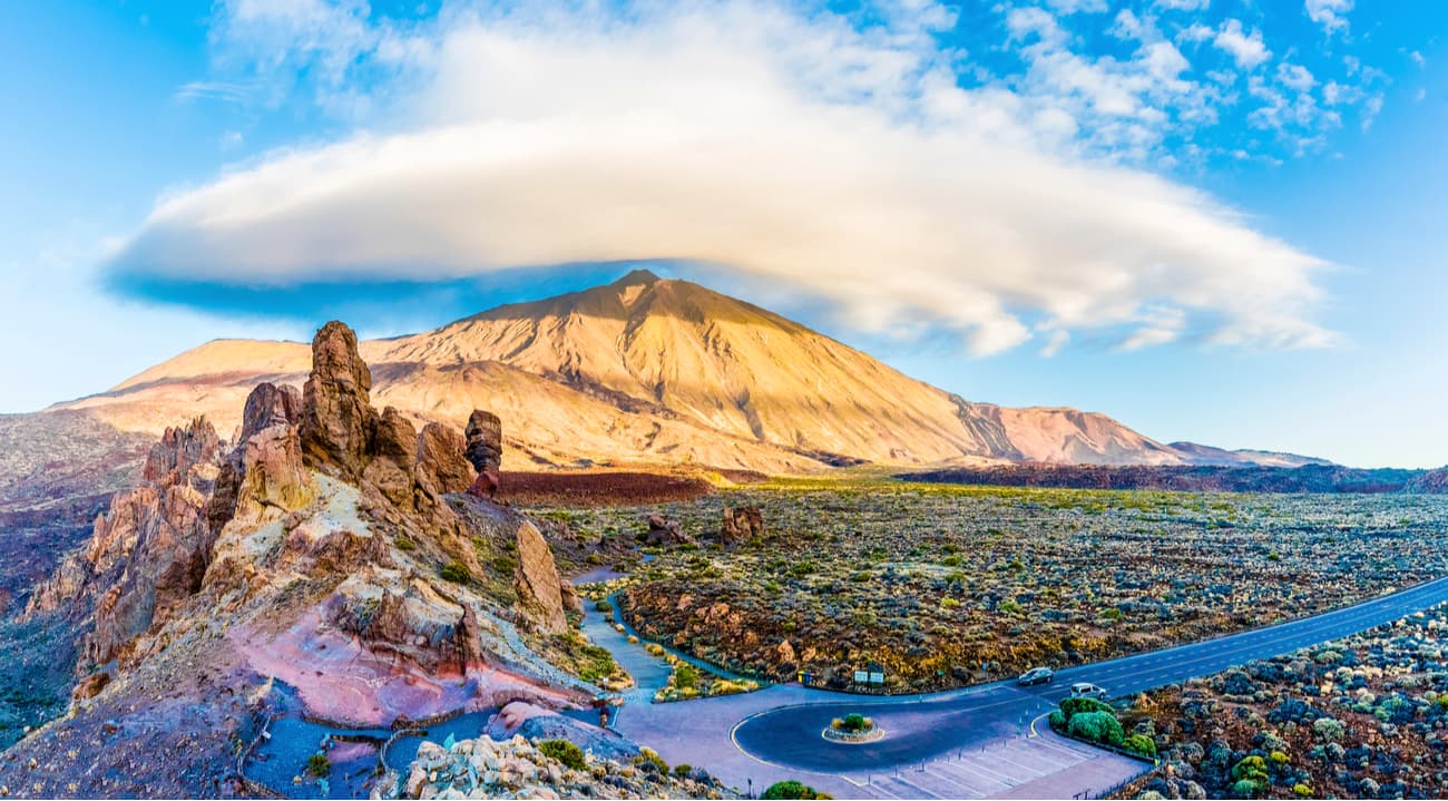
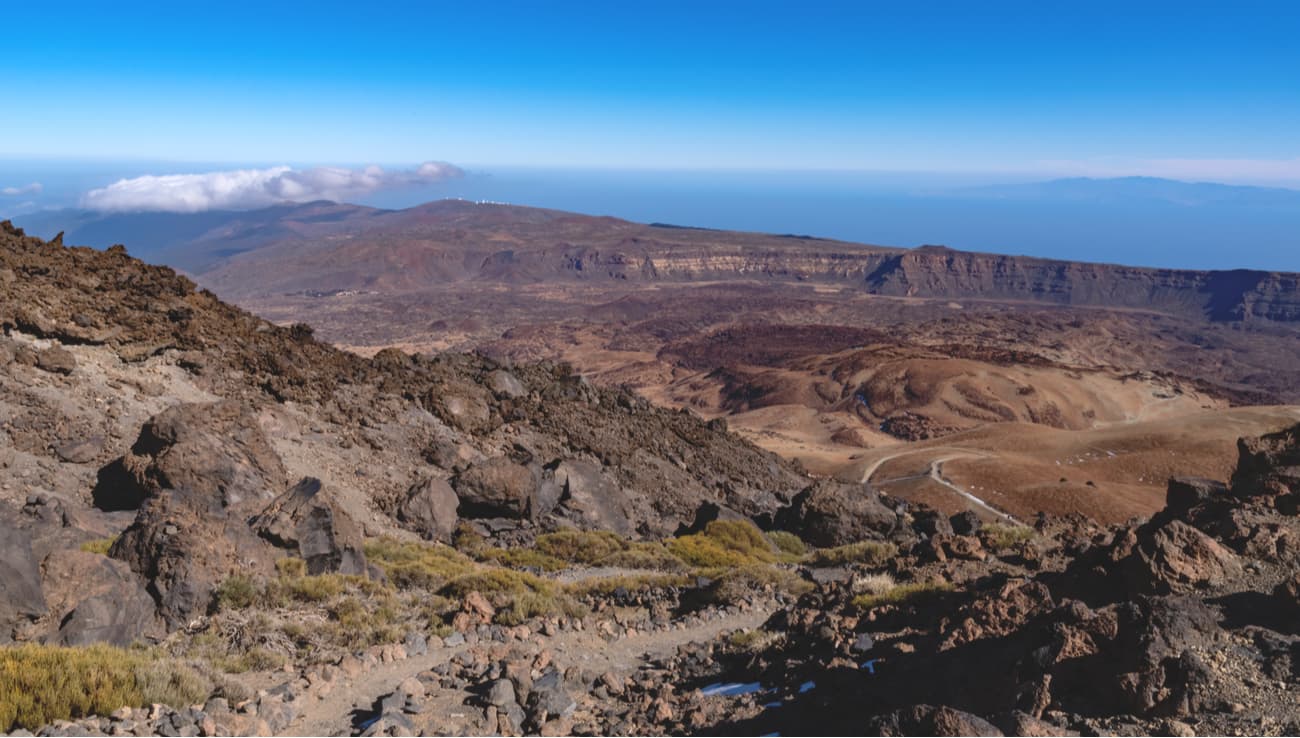
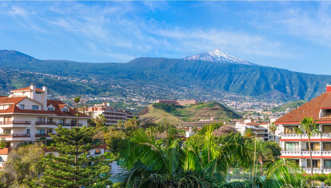
Mount Teide is the third tallest and largest volcano on the planet after Mauna Loa and Mauna Kea in Hawaii. Teide is the highest mountain in the Canary Islands (and in all of Spain.) Its formation began 170,000 years ago after a giant slide of the previous volcano which was even larger than the current one. During that slide, Las Cañadas caldera was formed. Today we can only see part of its wall because Teide grew inside and filled the caldera in. The visual impact of Teide is all the greater due to atmospheric conditions that create constantly changing textures and tones in the landscape and a ‘sea of clouds’ that forms a visually impressive backdrop to the mountain.
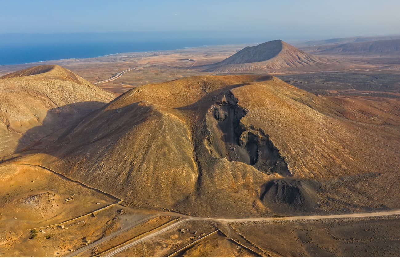
The volcano strata grow due to the overlapping lava layers in the course of successive eruptions. Over the last 20,000 years, most eruptions (Montaña Blanca, Pico Cabras, etc.) have occurred mainly around the base of Mount Teide because it is much more difficult for lava to reach a much higher peak.
According to the beliefs of the Canarian indigeneious peoples (Guanches), Guayota, the king of evil, aka the demon, lived inside Teide (hell) and kidnapped the god Magec (the god of light and sun) taking him inside Teide. The Guanches prayed Achaman, their supreme god, for mercy. Achaman managed to defeat Guayota, removed Magec from the bowels of Mount Teide and plugged the volcano’s crater. They say that the stopper Achaman put on is the last cone of the volcano, it is whitish in color and crowns Mount Teide.

In the ancient classical world, Mount Teide aroused great fascination. Thus, the Greek historian Herodotus mentioned Teide on two occasions: “The Atlantean is outstanding as a cylindrical figure. It is said that it is so high that its summit cannot be seen because it is always covered with clouds in winter and summer, and its inhabitants call it the Column of Heaven.” Herodotus's other account reads as follows: "There is in those seas a mountain called Atlante, which is high, round and so eminent that its summit cannot be well discerned."
In his work “Natural History”, Pliny the Elder, a Roman writer (AD 24-79), mentions the snow that King Juba and its envoys saw on the islands: “Cloud-covered Ninguaria which received this name for its perpetual snows.”
During the Renaissance, many historians and adventurers began to identify and relate the Atlantic islands with the remains of the Atlantis, and Mount Teide with Mount Atlas, the Canary Islands representing the highest parts of the lost sunken continent.
Due to its imposing altitude, during the time of the European expansion, El Teide was considered the highest mountain in the world, since it was used as a beacon in navigation through the Atlantic Ocean to the south by Spanish, Portuguese, and British sailors.

From the geomorphological point of view, Teide is a sheer wonder of nature. The structure of the caldera and the Teide-Pico Viejo stratovolcano are unique on the planet. The vicinity is also well-worth the visit. There are hundreds of cones, castings or caves that enrich scientific and landscape interest of the researchers. We need to add its wealth of fauna and flora to the mix, with a large number of Canarian endemics and unique species.
The Teide National Park was created in 1954 in recognition of its volcanic and biological uniqueness. It covers almost 19,000 hectares, which makes it the largest and oldest national park in the Canary Islands. It has a Peripheral Protection Zone, and is surrounded by the Corona Forestal Natural Park, which, with 46,612.9 hectares, is the largest protected natural area in the entire Canary Islands.
Touring the area, even by car, is a sight to behold. The landscape is overwhelming no matter where you look. To get to know it in greater depth, it’s best to go up one road and go down using another one. The greatest contrast occurs if you arrive either from the north or from the south. The snow of the peak together with the lava flows that spill down its slopes form a unique combination that you cannot help admiring.

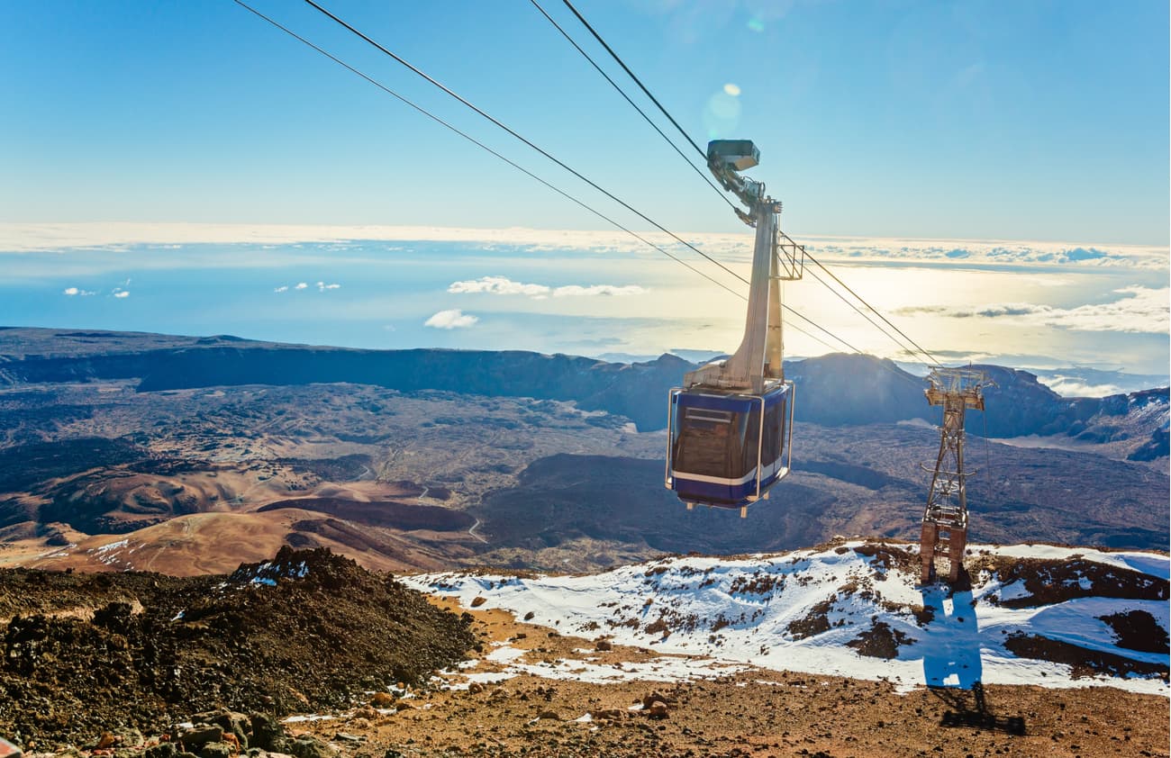
Some people decide to make the ascent to Teide in the fastest, easiest and most comfortable way, that is, taking the Teide Cableway (2,356 to 3,555 meters above sea level) and accessing the Telesforo Bravo trail (Teide peak) thanks to a previously requested permit. On the other hand, there are those who decide to hike up and enjoy Montaña Blanca trail, one of the most impressive trails on the island of Tenerife.
The Teide National Park is the most visited park in Europe (and one of the 10 most visited in the world) as well as the World Heritage Site since 2007. Its visit is totally mandatory during a trip to the island of Tenerife.
For many, Teide is an unknown volcano. Some even cannot fathom that it’s an active volcano. The proof are the numerous fumaroles and the strong smell of sulfur that is clearly smelt at the top of this mountain. Should you wish to get to its peak and find yourself for a few moments at the highest point in the country, there are some options to reach Teide.
Teide is 3,715 meters above sea level. At 2,356 meters a.s.l, there’s the Teide Cableway that rises from 2,356 m to 3,555 m in just 7 minutes.
During the ascent on the Teide cableway, you go along one side of the volcano enjoying magnificent views of the great Caldera de las Siete Cañadas and you are located just 163 meters below the highest point of the volcano, the crater or Pico del Teide. We recommend buying the cableway tickets in advance, if you choose to do it with an audio guide you will be able to roam freely along the path to the Mirador de Pico Viejo and the Mirador de La Fortaleza.
The Teide Cableway costs 13.5 EUR one way. It’s open from 9am to 5pm if the weather allows it, which happens most of the year. In case of strong winds and snow, it is closed to the public access for security reasons.
This option is very worthwhile for those who don’t want to spend a full day hiking on Teide volcano. You have different options of getting on and off the Teide Cableway, walking up and down the cableway, etc.
Hiking up to Teide peak is possible via trail number 10, the Telesforo Bravo trail. Normally, it takes about 35 minutes to do this walk. It’s a well-marked and short trail (less than 1 kilometer), however, the lack of oxygen is quickly noticeable (20% less at this altitude), thus if you have any issues with cardio-vasclular system, consult your doctor before going up.
Getting the permit issued by the Teide National Park management can be quite a challenge. Not because of the technical difficulty, but because there are many requests and not too much availability: only 200 permits are issued per day.
What can you do if you can’t get a permit? What are the alternatives to hike up Teide without a permit if you haven’t arrived on time to obtain the free permit that allows you to reach the top?
Please note it’s not possible to hike up Teide peak without a permit unless you spend the night in Refugio de Altavista, but there are alternative activities if, for whatever reason, you can’t get a permit to hike up Mount Teide on your own.
The following are some important viewpoints and trails within the National Park that will be mentioned with some frequency during the rest of the article:
The start point of the hike to Teide is the trail of Montaña Blanca which offers more than a dozen parking spaces. The trail is very well signposted from the road with a sign that says Montaña Blanca and Refugio de Altavista.
The ascent walk to Mount Teide can be done over one morning if you ascend on foot and descend by cableway, for example. Or, you can start in the afternoon and stay overnight at Refugio de Altavista (located on Teide volcano) and thus ascend to the early morning peak to enjoy the sunrise.
Getting to Teide peak from the Montaña Blanca trail takes approximately four and a half hours.
The total length of the trail is 8.3 km with a maximum difference of 1,350 meters, so the difficulty of this trail is high.
The first part of the walk or hike to Teide consists of walking along an almost flat path of approximately 5 kilometers.
The pumice stone is the highlight of the beautiful scenery. In some areas, it surrounds large accretion balls (the most famous of which are known as "Huevos del Teide") in order to break the almost bleak monochromaticity of the soil.
This section is completed in about an hour and a half and during this part we can see the north of the island of Tenerife, the Izaña region (the Teide Observatory), and La Fortaleza. This walk is simple and the most comfortable part of the trail.
A sign with a large map marks the beginning of trail number 7, known as La Rambleta.
Here is where the real ascent to Teide volcano begins.
The lack of oxygen is noticeable in this part of the trail due to the altitude, but the landscape is breathtaking.
Finally, we reach Refugio de Altavista, which is nothing more than a small high mountain house. It has a living room with a fireplace, kitchen, bathrooms and several shared rooms with bunk beds, everything is very simple and rustic.
From there, it’s possible to discover the constellations of late summer: Cassiopeia, Drago, Ursa Minor, Pegasus, the summer triangle, Escorpius, Sagittarius and some others if you know your astronomy well.

There’s a trail behind the shelter that leads to the cableway. Located at 3,555 metres above sea level, the cableway trail ends in about 7 minutes, in the area of La Rambleta. From this point, there are only 163 meters left to reach the crater.
During this last section, the wind intensifies, you can smell the sulfur and your heart will probably beat faster.
If the weather is good enough, it’s possible to see all the islands of the Canary archipelago.
It takes about 3 hours to complete the ascent from Refugio de Altavista to the Teide peak.

Of all the alternatives to hike Teide without a permit, this is without a doubt the most recommended.
The Pico Viejo trail starts from La Rambleta and ends at a viewpoint with views of the crater of Pico Viejo volcano. It takes 30 minutes and 751 meters to reach the point. It’s of medium difficulty.
The beauty of this journey is not only the end at the viewpoint, but the trail itself, which is one of the most beautiful viewpoints in Spain.
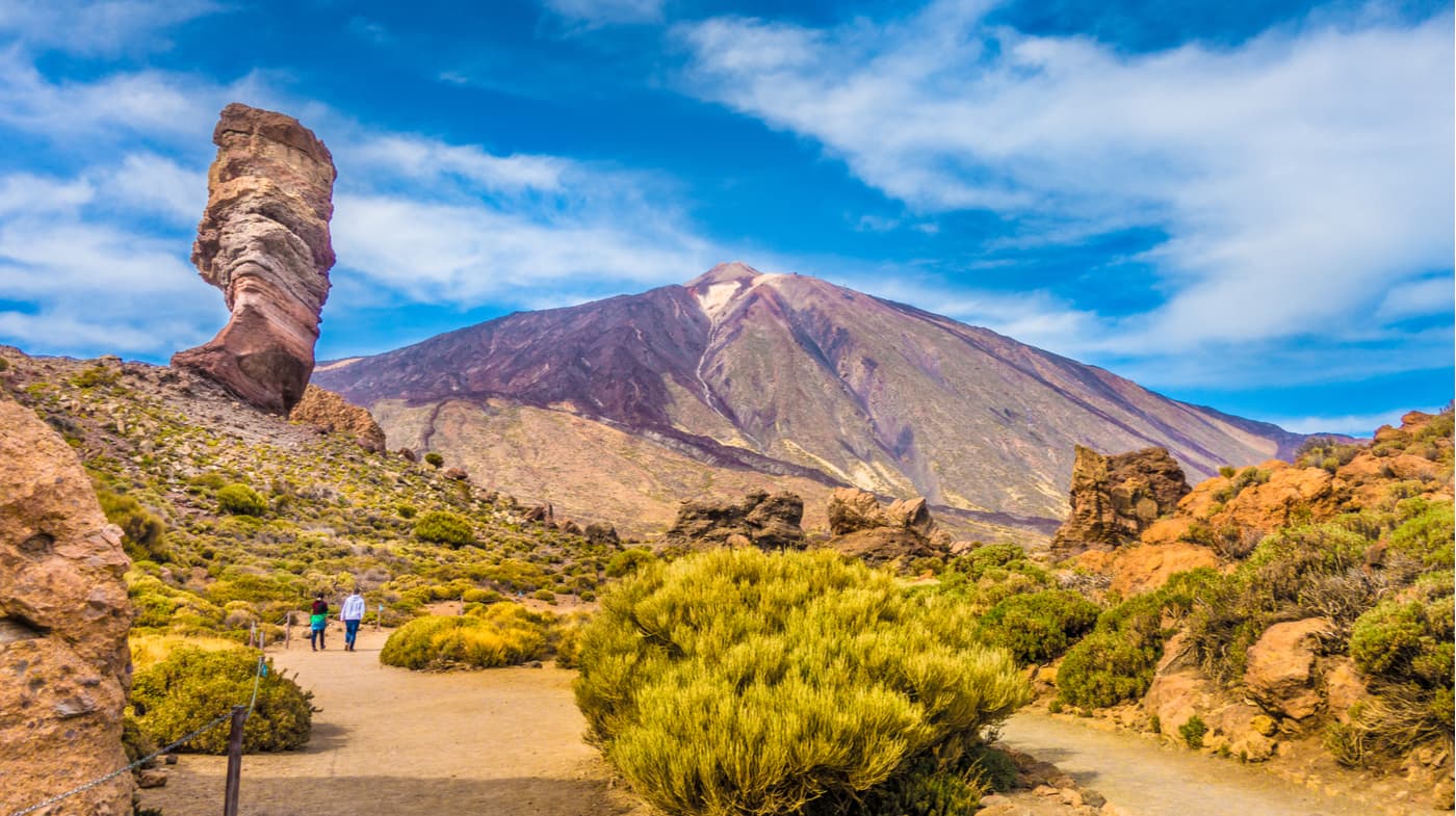
The Pico Viejo trail begins with panoramic views of the Caldera de las Cañadas, which today marks the limits of the Teide National Park. As you progress, you will find solid yellowish remains, a work of the gases expelled from the bowels of the volcano that is still active. There are fumaroles on the sides of the trail and other spectacular formations such as the famous Corbata del Teide or Roques de García.

After walking through tongues of lava along the path of great scenic and volcanological value, we arrive at the viewpoint from which you will see the peculiar crater of the Pico Viejo volcano.
It’s 800 meters in diameter and has a variety of unbelievable colours. The huge crater has experienced explosions of various materials coming to the land surface through different escape routes, the combination of these materials has resulted in what is today the incredible mantle of the Pico Viejo crater which offers one of the most spectacular views of Mount Teide.
There’s a chain of volcanoes in the background, the Teno massif and the islands of La Gomera, El Hierro and La Palma.
The return will be made by the same trail, and at the end you will have to go down to the cableway base station. If you decide to hike at sunset, you’ll see Gran Canaria with the shadow of Teide. The torrent of colors that will flood the scene will enchant you. If you are a fan of the sunsets, you cannot miss this one from the Pico Viejo viewpoint.

This route also departs from La Rambleta. It’s 25 minutes and 585 meters long.
It runs entirely through lava channels. It’s a different route that also goes through fumaroles and surprising volcanic formations. It ends at the viewpoint located above La Fortaleza, a large remnant isolated from the caldera wall.

In general, people do not suffer from altitude sickness in Teide, but you can experience some dizziness or minor headaches. That being said, keep in mind that this route to Teide reaches 3,715 meters above sea level, so in case of severe dizziness and vomiting you’ll have to descend immediately.
We also recommend that you check the weather forecast for the day you wish to hike Teide and avoid bad weather days (especially stormy weather).
If you don’t want to ascend and descend Teide on foot, you have the option of doing one part on foot and the other by the Teide cableway. Keep in mind that the Montaña Blanca trail does not start at the same point where the Teide Cableway is located (which is 3 km away).
If you want to access the Pico del Teide from 9 a.m. in the morning, you will have to get the permit to access it.

The Canary Islands may not have the most vertical walls or menacing cliffs, but climbing in the impressive natural setting of Las Cañadas, in the Teide National Park, next to the highest peak in Spain, is a unique experience that is lived at more than 2,000 meters of altitude. Its spectacular volcanic formations hide numerous areas of great interest. One of the most popular is the Cañada del Capricho, with itineraries equipped for sports and block events.
One of the walls preferred by climbers where climbing is authorized without limitations is Roque La Catedral, an impressive volcanic rock. With a maximum height of 120 meters, it groups together quite a few routes on its west side, although those on the north side are the ones with the greatest challenge. This rock formation is part of the Roques de García, one of the most visited places in the Teide National Park, with amazing views of the Ucanca plain and great geological wealth.

Access to the Cañada del Capricho. Once in the Teide National Park, you have to get to the parador and leave your car in the adjacent parking lot. Go to trail number 4 (Siete Cañadas). After several minutes you come to a track. Take a left until you can see the guardhouse of the park.
Access to the Roque of La Catedral. Pass the parador and park a little farther ahead, on the right-hand side. Go in the direction of the viewpoint, from where you can see the Cathedral, and take the path that leads directly to it.
TF-38 Boca Tauce-Chio: It’s only a 52 km drive and along the road, you can enjoy the Chinyero volcano responsible for Tenerife's last volcanic eruption in 1909.
From the south, TF-21, via Arona and Vilaflor: It’s only a 47 km drive and you can make an en-route stop to visit the highest town in Spain.
From the north, TF-24 La Laguna-El Portillo, via La Esperanza. This is the longest route, between 55 and 64 km, but it’s also the ideal route to witness the phenomenon known as the ‘sea of clouds’.
From the north, TF-21 La Orotava-Granadilla, via La Orotava: it’s only a 45 km drive. You can stop off and stroll around La Orotava, a lovely historic town, while enjoying the 17th and 18th century Canary Island architecture.

348 line, from Puerto de la Cruz 342 line, from Adeje
Teide National Park:
Vilaflor:
Vilaflor de Chasna is an essentially rural municipality located on the hillsides of southern Tenerife. It covers an area of 56.26 sq.km. and stands 1,500 m above sea level, making it one of the highest towns in Spain. It borders La Orotava, Arona, Granadilla de Abona, San Miguel and Adeje. Its scenic value is undeniable, and its economy relies significantly on potato crops, vineyards and almond groves thanks to the quality of its soils and the abundance of good water.

Ever since the 16th century, Vilaflor de Chasna has welcomed visitors who arrived along the Royal Road of Chasna drawn by the town's proximity to Mount Teide and its pleasant climate, making it popular among botanists, scientists and also people with ailments looking to recover in this peaceful environment. After a long day of hiking, you might want to relax in the Hotel Spa Villalba.


