
Scan the QR code and open PeakVisor on your phone
There are mountain aficionados out there looking for both comfort and impressive mountains. And who can blame them? They’re always looking for a five-star chalet with a parking lot from which they can reach a spectacular 2,500+ peak in a couple of hours and get back for a cosy nap. Or they might be driving a trailer and feeling awesome on a high altitude motorway. Bagging a peak in flip flops and pyjamas, isn’t that a treat? If this sounds familiar, then look no further!
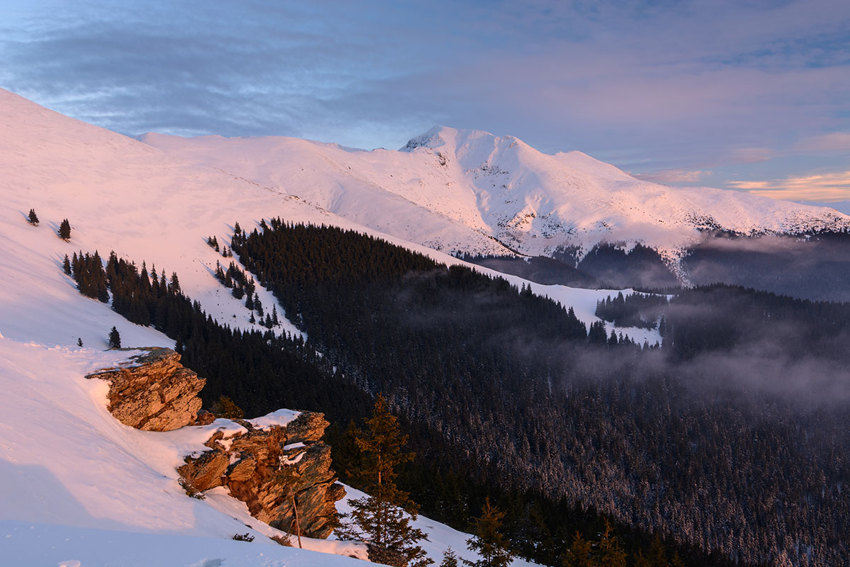
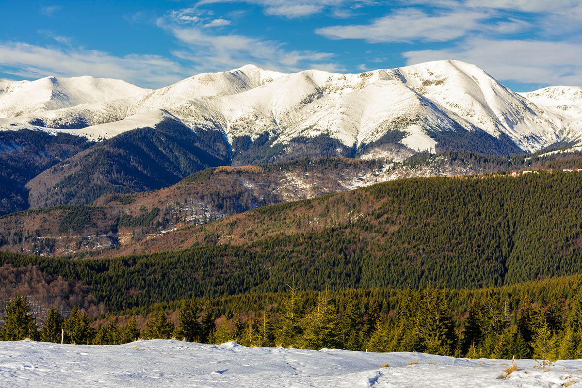
The Parâng are tall rocky mountains in the Southern Carpathians stretching in-between the Jiu, Strei and Olt rivers. The mountains are situated in the south-west of the Parâng-Şureanu-Lotrului group, being also the tallest among them. Their length is also impressive, over 50 km, and they are 25km wide. The maximum altitude is 2,519m on Parângul Mare peak (the most prominent peak in Romania), yet there are many impressive summits under that altitude, such as Cârja (2,405m), Gemănarea (2,426m), Stoieniţa (2,421m), Setea Mare, and Mohorul (2,337m).
Cârja peak
Parângul Mare peak is the fourth tallest in Romania (2,519m), and the tallest outside the Făgăraş range. This is a peak sought for the similarities of its surroundings with the Făgăraş and Retezat ranges. The same long, steep ridges and many glacier lakes make Parângul Mare an impressive mountain.
Also, the access to the Parâng is fairly easier than to the Făgăraş range. Getting to the range from Bucharest takes around 3.5h, the destination being Rânca, a well-known ski resort in Parâng. Use the Transalpina motorway to pass Rânca and reach the Urdele pass. From there, a tourist trail will get you in 4-5h to Parângul Mare peak. Another way to get to the highest point of Parâng is from Petroşani, if you happen to drive from Timisoara, Arad or Cluj. From Petroşani you keep on driving on DN7A until you reach the Groapa Seaca chalet, where the trail begins.
Although using Transfăgăraşan to get near Balea lake in the Făgăraş range clocks in a similar amount of time, there are benefits in winter when Transfăgăraşan motorway is closed. On the opposite, the road to Rînca is open, so is the one starting from Petroşani. Also, the Parâng range will receive less amount of snow in winter, and the overall safety is greater than that of the Făgăraş range.
The glacial landform is combining harmoniously with the Carpathian landform, opposing large U-shaped valleys and steep ridges to conical, short peaks and large, undulated plateaus. You will discover crags, impressive postglacial cirques and tarns, which make the Parang a mountain a wild place with spectacular scenery.
Similar to the Făgăraş, the north ridges are short, while the southern ridges are way longer, covered in thick woods and lonely rocks in their upper part. In the south, the presence of limestone and the overlapping water catchment area create beautiful gorges, such as the Olteţului, Galbenului, Jieţului or Polatiştei. Also, here you can find the most famous caves in the country: Muierii and Polovraci.
The weather in Parâng is characteristic to that of high mountains, with big temperature variations between the south and north faces. The number of days with temperatures below zero is high at altitudes above 1,850m, around 250-265 annually. In winter, wind speeds of up to 40-55m/s are possible, with dominant west and north-west winds. Also, the snowpack will last for about 180-200 days, with a thickness of up to 7-8m. Where there is a permanent shadow, the snowpack can last for years in a row.

As in all mountains in Romania, you need to pay attention to wildlife and take all necessary precautions. You may encounter bears (Ursus arctos), wild boars (Sus scrofa), wolves (Canis lupus), and in the southern areas of the Parâng vipers are seen frequently (Vipera amodytes). Another encounter you’d better avoid is the one with the lynx (Lynx lynx), those magnificent beasts are fierce and do extensive damage with their bite and claws.
All other chalets are to be found near national or regional roads, so you can access them by car.
The Transalpina motorway, also known as the Road of the King, crosses the Parâng mountains, it is the highest motorway in the country. It reaches the altitude of 2,145m at the Urdele pass. A lot of extreme sports activities, such as mountain bike, enduro, 4x4 or ATV are common in the Parâng range, especially in areas where pedestrian routes are not feasible due to very long distances. The most attractive marked trails will start from Petroşani and aim for the main “destination points” of Parâng: the glacial lakes, the ridge trail and Parângul Mare peak.
Take the road between Petroşani and Voineasa, DN7A. You should reach the Groapa Seacă chalet in 20 km. The trail (red circle) starts at 1,200m and will take you over 13km in some 5 to 6.5h depending on your fitness and backpack weight. You want to keep an eye for the red circles as there are many sheep trails that will cross paths with yours. As you go up the Jieţului valley, you will encounter five glacial lakes, the last one being at the highest altitude in Parâng. Having reached the main ridge, you will encounter the red-band trail. From here, you have another 20 minutes to Parângul Mare peak. You can either continue on the ridge trail or get back in the same way, descending in around three hours or less.
The ridge trail is marked with a red band, so it should be easy to follow. You want to reach Nedeii clearing to get started, so you can use the Petroşani cable car to get there. From here, you will charge towards Cârja peak, then move on to Parângul Mare. Enjoy the views and head straight for the Piatra Tăiată pass, then descend for lake Câlcescu. This is where the first day should end, as you can bivy or camp around it. This segment will take you around 6-7 hours.

The next segment takes you from the lake back the Piatra Tăiată pass, then up to Mohorul peak. From here, you want to descend towards the Dengherul pass and finally reach Rânca cabin. We recommend using PeakVisor 3D map, having a print map for a backup and compass knowledge, as this segment requires proficient terrain navigation, especially in foggy days. Most of the markings on the trails are lacking maintenance so you will need extra attention while navigating. You can look for cairns, as they were built to help out confused travellers. This is a way to get you through poorly marked sectors or when the weather is hindering your vision. This segment will clock in another 6-7 hours.

PeakVisor 3D map of Piatra Tăiată - Mohorul ridge section
A spectacular route that can be made with little effort is the one leading to the three lakes, the Cîlcescu, the Pencu, and the Vidal. The route starts from Obârșia Lotrului chalet, and goes up to the Lotrului Valley. The marking is a red cross combined with a red triangle and takes up to 6-7 hours to complete.
The adjacent valleys, Latoriței and Jieț, also lead to a lot of glacier lakes, so if you are passionate about them, a circuit of each valley will provide awesomeness at a relatively low effort.

Mohorul peak
Petroşani is a small mining city from where you can start your Parâng journey. Just 8 km away you will find the Rusu Hotel, an ex-chalet situated at 1,168m. From here, you can take the trails that lead to a chalet complex at 1,600m, this being the easiest way to the massif. Also from Petroşani, you can reach Groapa Seacă chalet, situated in Cheile Jieţului, 18 km outside the city.
Just before getting to Rânca ski resort, there is a small town of Novaci. From here you get access to Cerbu mountain and pass Rânca chalet on your way to the main ridge.

You can access the massif starting from Peştera Muierii chalet, where you can get by car in half an hour.


