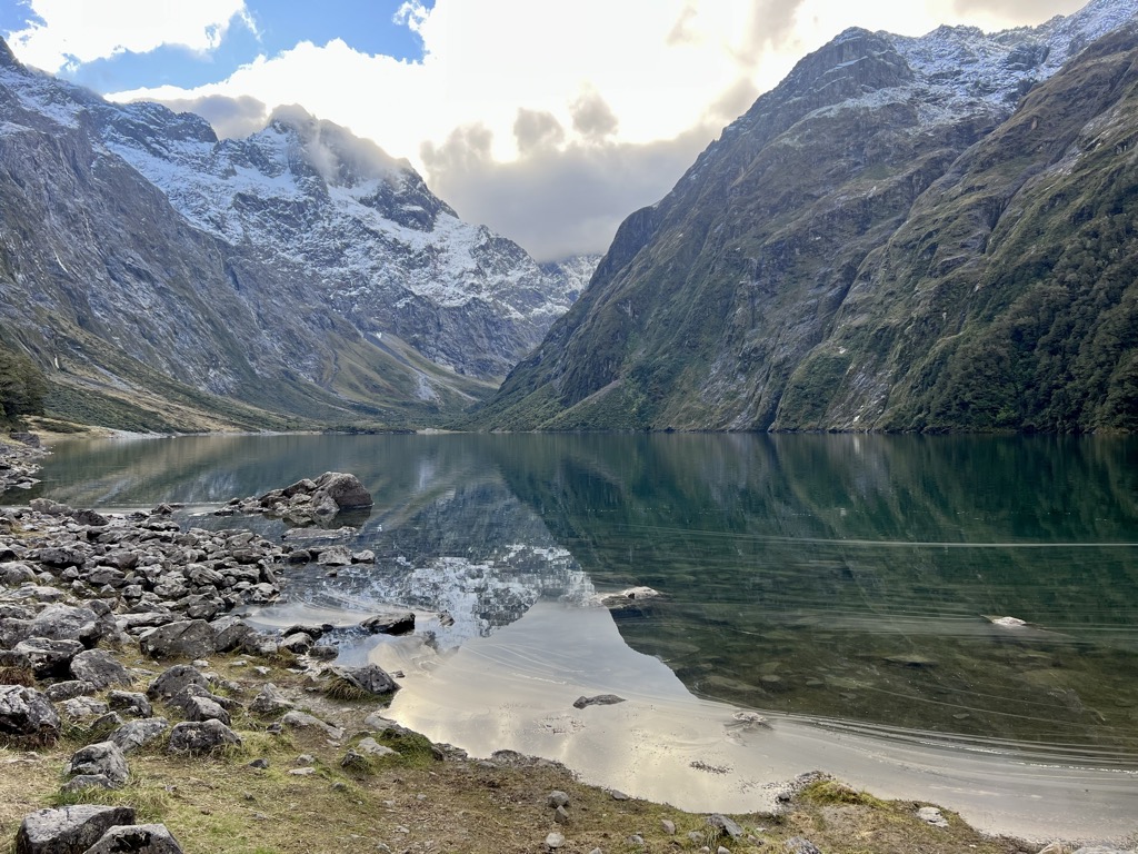
Lake Marian is an alpine lake at the southern end of the Darran Mountains in the Fiordland National Park in the South Island of New Zealand. The lake is located just above the treeline in a hanging valley leading northwest from the Hollyford Valley near The Divide pass. The valley is sheltered by steep snow-covered peaks of over 2,000 metres (6,600 ft) on all sides apart from the entrance. The lake is fed and drained by Marian Creek which in turn feeds into the Hollyford River / Whakatipu Kā Tuka. Marian Creek's catchment upstream of Lake Marian includes several permanent snowfields in a cirque at the head of the valley northeast of the peak of Mount Crosscut. There the creek drains two smaller alpine lakes, Lake Mariana and Lake Marianette, followed by the 122 metres (400 ft) tall Lyttle Falls, before it reaches Lake Marian. A 3-hour return tramping track leads to the lake from a car park along the Hollyford Road, only 1 kilometre in from the Milford Road (SH94). The track starts by crossing the Hollyford River on a swing bridge before leading upstream alongside Marian Creek as it cascades over a series of small waterfalls. After this, the track becomes rougher and can be muddy in places, with the climb up to Lake Marian strenuous as it ascends almost 400 metres (1,300 ft) in height. A good view of Lake Marian as it sits in the hanging valley between the peaks of Mt Christina, Mount Crosscut, and Mt Gunn can also be glimpsed from Key Summit on the opposite side of the Hollyford Valley on a short side track from the Routeburn Track.
We use GPS information embedded into the photo when it is available.
3D mountains overlay
Adjust mountain panorama to perfectly match your photos because recorded by camera photo position might be imprecise.
Move tool
Rotate tool
Zoom
More customization
Choose which peak labels should make into the final photo and what photo title should be.
Next
Photo Location
Satellitte
Flat map
Relief map
Latitude
Longitude
Altitude
OR
Latitude
°'''
Longitude
°'''
Apply
Register Peak
Peak Name
Latitude
Longitude
Altitude
Register
Teleport
PeakVisor
This 3D model of Sagarmatha National Park in Nepal was made using the PeakVisor app topographic data. The mobile app features higher precision models worldwide, more topographic details, and works offline. Download PeakVisor maps today.
Download OBJ model
PeakVisor
The download should start shortly. If you find it useful please consider supporting the PeakVisor app.
PeakVisor for iOS and Android
Be a superhero of outdoor navigation with state-of-the-art 3D maps and mountain identification in the palm of your hand!