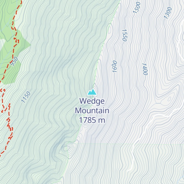
Wedge Mountain is a 5,860-foot-elevation (1,786-meter) summit located in Chelan County of Washington state. It is set on the boundary line of the Alpine Lakes Wilderness, on land managed by Okanogan-Wenatchee National Forest. Wedge Mountain is the northeastern terminus of the Stuart Range, which is a subset of the Cascade Range. It is situated 3.5 miles (5.6 km) northeast of The Temple, and the nearest town is Leavenworth, 5 miles (8.0 km) to the north-northeast. Precipitation runoff from the mountain drains into tributaries of the Wenatchee River. Topographic relief is significant as the summit rises over 2,800 feet (850 meters) above Snow Creek in one-half mile. Backpackers hiking en route to The Enchantments via the Snow Creek Trail traverse the western foot of this mountain. Wedge Mountain is the toponym officially adopted by the U.S. Board on Geographic Names for the 5,860-foot summit.
We use GPS information embedded into the photo when it is available.
3D mountains overlay
Adjust mountain panorama to perfectly match your photos because recorded by camera photo position might be imprecise.
Move tool
Rotate tool
Zoom
More customization
Choose which peak labels should make into the final photo and what photo title should be.
Next
Photo Location
Satellitte
Flat map
Relief map
Latitude
Longitude
Altitude
OR
Latitude
°'''
Longitude
°'''
Apply
Register Peak
Peak Name
Latitude
Longitude
Altitude
Register
Teleport
PeakVisor
This 3D model of Sagarmatha National Park in Nepal was made using the PeakVisor app topographic data. The mobile app features higher precision models worldwide, more topographic details, and works offline. Download PeakVisor maps today.
Download OBJ model
PeakVisor
The download should start shortly. If you find it useful please consider supporting the PeakVisor app.
PeakVisor for iOS and Android
Be a superhero of outdoor navigation with state-of-the-art 3D maps and mountain identification in the palm of your hand!