Available for connected Garmin and Suunto accounts.
Scan the QR code and open PeakVisor on your phone
Slioch map
Slioch
N
Add photo
981 m
Elevation
Elevation is the altitude of a place above sea level.
619 m
Prominence
Peak’s prominence is the least vertical to be covered to get from the summit to any other higher terrain.
Proportional Prominence901 m
Munro
Mountains in Scotland with a height of over 914 m / 3 000 ft bear a special name, the Munros. They are named after Sir Hugh Munro, the 4th Baronet (1856–1919), who produced the first list of such hills, known as Munro’s Tables, in 1891.
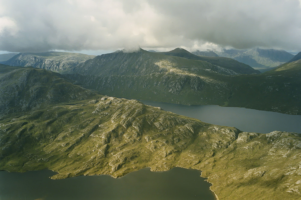
Slioch (Scottish Gaelic: Sleaghach) is a mountain in the Scottish Highlands situated in Wester Ross, eight kilometres north of the village of Kinlochewe. Slioch reaches an elevation of 981 metres (3,219 feet) and towers above the southeastern end of Loch Maree to give one of the best known and most photographed sights (from the A832 road) in the Highlands. VisitScotland, the Scottish national tourist agency, has used video footage of Slioch in its television advertisements.
The mountain is composed of Torridonian sandstone on a base of Lewisian Gneiss and has steep crags on three sides and allows easy access for the walker only from the south east where the large open corrie of Coire na Sleaghaich has two ridges on its flanks which the walker can use. The mountain's name comes from the Gaelic word "sleagh" and means "the spear" and this only becomes obvious when Slioch is viewed from Lochan Fada to the northeast, from here the subsidiary top of Sgùrr an Tuill Bhàin (The Peak of the White Hollow) (933 metres) dominates as a slender peak and gives the mountain its name. Feral goats are often seen on the mountain.
There's a demading hiking trail (T3) leading to the summit.
By elevation Slioch is
# 94 out of 6015 in the Northwest Highlands
By prominence Slioch is
# 41 out of 4967 in Highland # 67 out of 18277 in Scotland # 79 out of 34760 in United Kingdom # 37 out of 6015 in the Northwest Highlands
We use GPS information embedded into the photo when it is available.
3D mountains overlay
Adjust mountain panorama to perfectly match your photos because recorded by camera photo position might be imprecise.
Move tool
Rotate tool
Zoom
More customization
Choose which peak labels should make into the final photo and what photo title should be.
Next
Photo Location
Satellitte
Flat map
Relief map
Latitude
Longitude
Altitude
OR
Latitude
°'''
Longitude
°'''
Apply
Register Peak
Peak Name
Latitude
Longitude
Altitude
Register
Teleport
PeakVisor
This 3D model of Sagarmatha National Park in Nepal was made using the PeakVisor app topographic data. The mobile app features higher precision models worldwide, more topographic details, and works offline. Download PeakVisor maps today.
Download OBJ model
PeakVisor
The download should start shortly. If you find it useful please consider supporting the PeakVisor app.
PeakVisor for iOS and Android
Be a superhero of outdoor navigation with state-of-the-art 3D maps and mountain identification in the palm of your hand!