Silver Star Mountain is a recently uplifted ridge of older Western Cascades volcanic rock, underlain by a granitic pluton of similar Western Cascades age, located in the Cascade Range in the U.S. state of Washington. (contrary to local legend, the mountain is not an "extinct volcano," but rather the uplifted debris and roots of a number of very old volcanic vents) Consisting of late Eocene to Oligocene epoch rock, it lies within the Gifford Pinchot National Forest. Silver Star is composed of three lithologic units (distinct units of rock, each with different physical characteristics), including the large Silver Star Granodiorite unit.
Silver Star Mountain and the surrounding area, in contrast to the rest of the local backcountry, has a ridge-like appearance, creating a striking skyline similar to mountains further north in the Cascade Range. The area lacks trees, and comprises steep cliffs, talus slopes, and meadows filled with wildflowers. The mountain can be hiked and has been noted for its trails by local mountaineers.
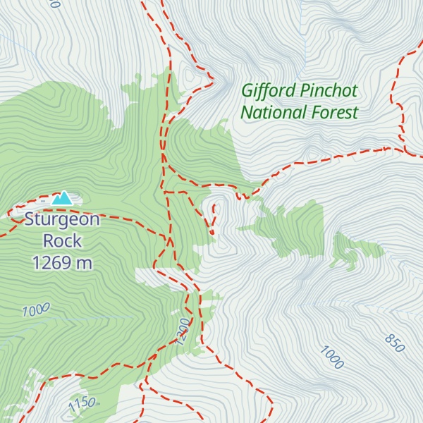
There's a trail called Silver Star Summit Trail #180D leading to the summit. Silver Star Mountain is one of the 1 peaks along the Silver Star Trail.
By elevation Silver Star Mountain is
# 76 out of 173 in Skamania County
By prominence Silver Star Mountain is
# 10 out of 173 in Skamania County # 16 out of 224 in Gifford Pinchot National Forest
We use GPS information embedded into the photo when it is available.
3D mountains overlay
Adjust mountain panorama to perfectly match your photos because recorded by camera photo position might be imprecise.
Move tool
Rotate tool
Zoom
More customization
Choose which peak labels should make into the final photo and what photo title should be.
Next
Photo Location
Satellitte
Flat map
Relief map
Latitude
Longitude
Altitude
OR
Latitude
°'''
Longitude
°'''
Apply
Register Peak
Peak Name
Latitude
Longitude
Altitude
Register
Teleport
PeakVisor
This 3D model of Sagarmatha National Park in Nepal was made using the PeakVisor app topographic data. The mobile app features higher precision models worldwide, more topographic details, and works offline. Download PeakVisor maps today.
Download OBJ model
PeakVisor
The download should start shortly. If you find it useful please consider supporting the PeakVisor app.
PeakVisor for iOS and Android
Be a superhero of outdoor navigation with state-of-the-art 3D maps and mountain identification in the palm of your hand!