Available for connected Garmin and Suunto accounts.
Scan the QR code and open PeakVisor on your phone
Sgùrr a' Mhaoraich map
Sgùrr a' Mhaoraich
N
Add photo
1 027 m
Elevation
Elevation is the altitude of a place above sea level.
526 m
Prominence
Peak’s prominence is the least vertical to be covered to get from the summit to any other higher terrain.
Proportional Prominence919 m
Munro
Mountains in Scotland with a height of over 914 m / 3 000 ft bear a special name, the Munros. They are named after Sir Hugh Munro, the 4th Baronet (1856–1919), who produced the first list of such hills, known as Munro’s Tables, in 1891.
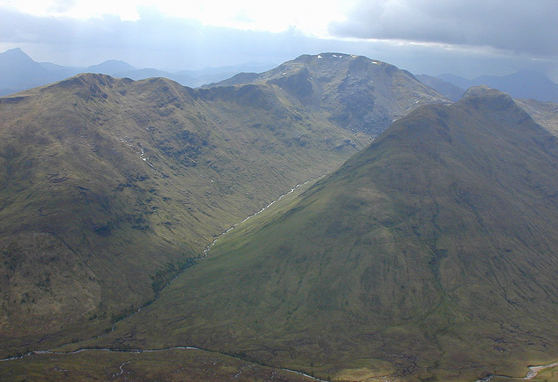
Sgùrr a' Mhaoraich is a Scottish mountain located to the north of Loch Quoich in the northwestern highlands. It has a height of 1027 m (3369 ft) and is classed as a Munro. Viewed from Kinloch Hourn to the west, or from the north, it shows large, steep, rocky flanks with a complex series of ridges and corries, but like its neighbours such as Gleouraich, its southern side is gentler and grassier.
The mountain was originally known as Sgùrr a' Mhoraire, meaning peak of the landowner, but has been changed on modern maps to Sgùrr a' Mhaoraich, which may be derived from the Gaelic maorach meaning shellfish. This may be a reference to the hill's ribbed summit, which has been said to resemble a shell.
The mountain is most commonly climbed from the shores of Loch Quioch to the south. A stalker's path leads up the Bac nan Canaichean ridge to the subsidiary top of Sgùrr Coire nan Eiricheallach (891 m or 2,923 ft), which is connected to the main summit by a 1.5 km ridge, which has a number of rocky outcrops which can be scrambled over or bypassed. An alternative, and less frequently climbed route is from the northeast end of Glen Quoich, by way of a stalker's path which runs the length of Coire a' Carorainn and to the rocky summit of An Bathaich (892 m or 2,927 ft), and from there south to Sgùrr a' Mhaoraich via a high bealach.
There's a trail leading to the summit.
By elevation Sgùrr a' Mhaoraich is
# 43 out of 6015 in the Northwest Highlands
By prominence Sgùrr a' Mhaoraich is
# 72 out of 4967 in Highland # 62 out of 6015 in the Northwest Highlands
We use GPS information embedded into the photo when it is available.
3D mountains overlay
Adjust mountain panorama to perfectly match your photos because recorded by camera photo position might be imprecise.
Move tool
Rotate tool
Zoom
More customization
Choose which peak labels should make into the final photo and what photo title should be.
Next
Photo Location
Satellitte
Flat map
Relief map
Latitude
Longitude
Altitude
OR
Latitude
°'''
Longitude
°'''
Apply
Register Peak
Peak Name
Latitude
Longitude
Altitude
Register
Teleport
PeakVisor
This 3D model of Sagarmatha National Park in Nepal was made using the PeakVisor app topographic data. The mobile app features higher precision models worldwide, more topographic details, and works offline. Download PeakVisor maps today.
Download OBJ model
PeakVisor
The download should start shortly. If you find it useful please consider supporting the PeakVisor app.
PeakVisor for iOS and Android
Be a superhero of outdoor navigation with state-of-the-art 3D maps and mountain identification in the palm of your hand!